Windy Cleuch

Valley in Roxburghshire

Scotland

Windy Cleuch

Greatmoor Hill Climbed up from Hermitage for Chris Watson's 900th Marilyn on a grey windy morning.
Name: Greatmoor Hill
Hill number: 1914
Height: 599m / 1965ft
Area:28B: The River Tweed to the English Border
Class: Ma,5D
Grid ref: NT 48982 00687
Summit feature: trig point
Drop: 163m
Col: 436m  NT470003
Greatmoor Hill Credit: Rude Health

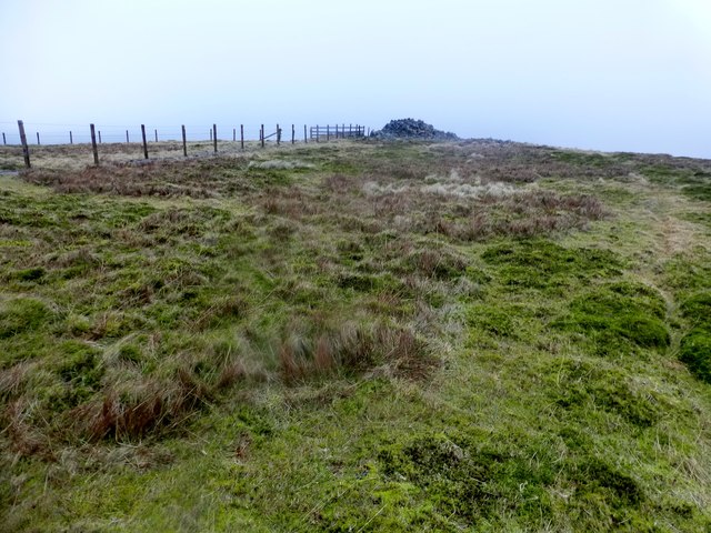
Windy Cleuch is a picturesque valley located in the Scottish Borders region of Roxburghshire. Nestled between rolling hills and surrounded by lush greenery, the valley is known for its stunning natural beauty and tranquil atmosphere. The name "Windy Cleuch" is derived from the Old English word "cleugh," meaning a narrow valley or ravine, and the area is indeed characterized by its narrow, winding shape.

The valley is home to a variety of wildlife, including red deer, pheasants, and various bird species. It also boasts a network of walking trails and hiking paths, making it a popular destination for outdoor enthusiasts and nature lovers. The surrounding hills offer breathtaking views of the valley below, making it a prime spot for photographers and artists seeking inspiration.

Windy Cleuch is steeped in history, with ancient ruins and archaeological sites scattered throughout the area. Visitors can explore the remnants of old settlements and learn about the valley's past through interpretive signage and guided tours. Overall, Windy Cleuch offers a peaceful retreat from the hustle and bustle of city life, where visitors can connect with nature and immerse themselves in the beauty of the Scottish countryside.

If you have any feedback on the listing, please let us know in the comments section below.

Windy Cleuch Images

Images are sourced within 2km of 55.28296/-2.7978934 or Grid Reference NY4999. Thanks to Geograph Open Source API. All images are credited.

Greatmoor Hill Climbed up from Hermitage for Chris Watson's 900th Marilyn on a grey windy morning.
Name: Greatmoor Hill
Hill number: 1914
Height: 599m / 1965ft
Area:28B: The River Tweed to the English Border
Class: Ma,5D
Grid ref: NT 48982 00687
Summit feature: trig point
Drop: 163m
Col: 436m  NT470003
Greatmoor Hill
Climbed up from Hermitage for Chris Watson's 900th Marilyn on a grey windy morning. Name: Greatmoor Hill Hill number: 1914 Height: 599m / 1965ft Area:28B: The River Tweed to the English Border Class: Ma,5D Grid ref: NT 48982 00687 Summit feature: trig point Drop: 163m Col: 436m NT470003
Summit of Greatmoor Hill
The ridge running northeast from Greatmoor Hill
Looking up Hermitage Hill from the valley of the Whitrope Burn
Whitrope Burn south of Whitropefoot The Whitrope Burn viewed from a bridge carrying the B6399, south of Whitropefoot.

This photograph was taken during the Coronavirus (COVID-19) pandemic of 2020/21/22.
Whitrope Burn south of Whitropefoot
The Whitrope Burn viewed from a bridge carrying the B6399, south of Whitropefoot. This photograph was taken during the Coronavirus (COVID-19) pandemic of 2020/21/22.
Hermitage Hill Hermitage Hill summit with a view to the distant Greatmoor Hill.
Hermitage Hill
Hermitage Hill summit with a view to the distant Greatmoor Hill.
Slight Bend In The Fence A slight bend in the fence with a distant view towards Greatmoor Hill.
Slight Bend In The Fence
A slight bend in the fence with a distant view towards Greatmoor Hill.
View Along Fence Towards Greatmoor Hill
Reedy Edge A view along the fence near Reedy Edge towards Greatmoor Hill.
Reedy Edge
A view along the fence near Reedy Edge towards Greatmoor Hill.
Hermitage Hill On the east-southeastern slopes of Hermitage Hill with the summit of Greatmoor Hill just visible over the horizon.
Hermitage Hill
On the east-southeastern slopes of Hermitage Hill with the summit of Greatmoor Hill just visible over the horizon.
A lone tree on Hermitage Hill A solitary stunted birch tree survives in a large area of rough grazing and heather moorland. Greatmoor Hill is to the left of the tree.
A lone tree on Hermitage Hill
A solitary stunted birch tree survives in a large area of rough grazing and heather moorland. Greatmoor Hill is to the left of the tree.
Hermitage Hill A moorland landscape to the north of the summit.
Hermitage Hill
A moorland landscape to the north of the summit.
Rough grazing on Hermitage Hill Hazy conditions on Hermitage Hill with Din Fell on the left, Dod Plantation in the centre and Dod Hill to the right.
Rough grazing on Hermitage Hill
Hazy conditions on Hermitage Hill with Din Fell on the left, Dod Plantation in the centre and Dod Hill to the right.
Braidliehope Many of the fittings still remain on this abandoned house.  Used today as a shelter by sheep.
Braidliehope
Many of the fittings still remain on this abandoned house. Used today as a shelter by sheep.
Barley Burn The Barley Burn runs down a steeply sided valley and is not actually visible in this view from the slopes of Winterlair Hill.  The heather-clad Reedy Edge lies beyond.
Barley Burn
The Barley Burn runs down a steeply sided valley and is not actually visible in this view from the slopes of Winterlair Hill. The heather-clad Reedy Edge lies beyond.
Moorland south of Greatmoor Hill Rough grazing on the gentle lower slopes of Greatmoor Hill.  A lone tree has survived the sheep.
Moorland south of Greatmoor Hill
Rough grazing on the gentle lower slopes of Greatmoor Hill. A lone tree has survived the sheep.
Reedy Edge The fence leads directly to the summit of Greatmoor Hill.  The contrast of grassland to heather was particularly noticeable when walking across the square.
Reedy Edge
The fence leads directly to the summit of Greatmoor Hill. The contrast of grassland to heather was particularly noticeable when walking across the square.
The Kip Looking across the square to The Kip, a fairly distinctive bump on the northwest side of Hermitage Hill.
The Kip
Looking across the square to The Kip, a fairly distinctive bump on the northwest side of Hermitage Hill.
Show me another place!

Windy Cleuch is located at Grid Ref: NY4999 (Lat: 55.28296, Lng: -2.7978934)

Unitary Authority: The Scottish Borders

Police Authority: The Lothians and Scottish Borders

What 3 Words

///early.interlude.files. Near Teviothead, Scottish Borders

Nearby Locations

Windy Cleuch

Related Wikis

Ninestane Rig

Ninestane Rig (English: Nine Stone Ridge) is a small stone circle in Scotland near the English border. Located in Roxburghshire, near to Hermitage Castle...

Hermitage Castle

Hermitage Castle is a semi-ruined castle in the border region of Scotland. It is under the care of Historic Scotland. The castle has a reputation, both...

Dinley

Dinley is a hamlet in the Scottish Borders through which Hermitage Water flows. == Etymology == The first element, din, seems to be the Cumbric word for...
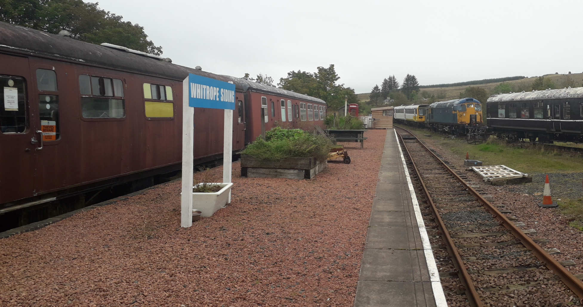
Whitrope Siding

Whitrope Siding was a trailing short siding or spur off the "up" (southbound) line, an associated trailing cross-over between up and down lines, a pair...

Nearby Amenities

Located within 500m of 55.28296,-2.7978934
Sundhope Flow
Place: locality
Lat/Long: 55.286519/-2.8002901
The data included in this document is from www.openstreetmap.org. The data is made available under ODbL.

Have you been to Windy Cleuch?

Leave your review of Windy Cleuch below (or comments, questions and feedback).