Capel Cleuch

Valley in Roxburghshire

Scotland

Capel Cleuch

Cauldcleuch Head summit from the south
Cauldcleuch Head summit from the south Credit: Iain A Robertson

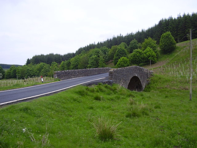
Capel Cleuch is a picturesque valley located in the Roxburghshire region of Scotland. Nestled in the heart of the Scottish Borders, this tranquil valley offers stunning natural beauty and a rich history.

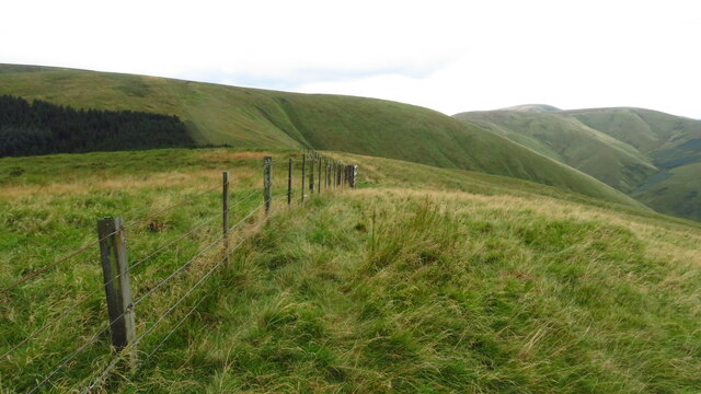
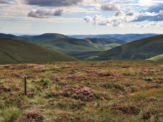
The valley is dominated by rolling green hills and picturesque landscapes, making it a popular destination for nature enthusiasts and hikers. The Capel Cleuch Burn, a small river that winds its way through the valley, adds to the charm of the area with its crystal-clear waters and soothing sounds.

Historically, Capel Cleuch was an important site for the farming community, and traces of this agricultural heritage can still be seen today. The valley is dotted with traditional stone farmhouses, some of which are still in use, while others have been converted into charming holiday cottages.

Visitors to Capel Cleuch can explore the area on foot, following the many walking trails that crisscross the valley. These trails offer breathtaking views of the surrounding countryside, including the nearby Eildon Hills and the Cheviot Hills. Wildlife enthusiasts will also be delighted by the diverse array of flora and fauna that can be found in the valley, including various bird species and native plants.

For those seeking a peaceful retreat away from the hustle and bustle of modern life, Capel Cleuch is an ideal destination. Its natural beauty, combined with its rich history and tranquil atmosphere, make it a truly special place to visit in Roxburghshire.

If you have any feedback on the listing, please let us know in the comments section below.

Capel Cleuch Images

Images are sourced within 2km of 55.299253/-2.8418013 or Grid Reference NT4600. Thanks to Geograph Open Source API. All images are credited.

Cauldcleuch Head summit from the south
Cauldcleuch Head Second Marilyn today after Greatmoor Hill with Chris Watson on a grey windy day.
Name: Cauldcleuch Head
Hill number: 1906
Height: 619m / 2031ft
Area: 28B: The River Tweed to the English Border
Class: Ma,G,D
Grid ref: NT 45655 00680
Summit feature:ground by fence post
Drop: 256m
Col: 363m  NT534016
Cauldcleuch Head
Second Marilyn today after Greatmoor Hill with Chris Watson on a grey windy day. Name: Cauldcleuch Head Hill number: 1906 Height: 619m / 2031ft Area: 28B: The River Tweed to the English Border Class: Ma,G,D Grid ref: NT 45655 00680 Summit feature:ground by fence post Drop: 256m Col: 363m NT534016
The Top Of Windy Edge A small gate of sorts at the top of Windy Edge as we near the summit of Cauldcleuch Head.
The Top Of Windy Edge
A small gate of sorts at the top of Windy Edge as we near the summit of Cauldcleuch Head.
Forest Ride Near Swire Knowe Looking towards a forest ride near Swire Knowe.  This is where the path from Braidlie, to the south, passes into the forest on its way to Priesthaugh.
Forest Ride Near Swire Knowe
Looking towards a forest ride near Swire Knowe. This is where the path from Braidlie, to the south, passes into the forest on its way to Priesthaugh.
Ascending Cauldcleuch Head Wet and rough
Ascending Cauldcleuch Head
Wet and rough
Above Langtae Syke Following the fence towards Langtae Hill
Above Langtae Syke
Following the fence towards Langtae Hill
Post, Footman Hass There is a wet vehicle track running along the fence but not much evidence of foot traffic on Footman Hass.
Post, Footman Hass
There is a wet vehicle track running along the fence but not much evidence of foot traffic on Footman Hass.
Gate, Footman Hass Looking towards Langtae Hill
Gate, Footman Hass
Looking towards Langtae Hill
Boggy ground above Langtae Hill
Cauldcleugh Head
Cauldcleugh Head
On Cauldcleuch Head summit - fence junction A rather wet summit.
On Cauldcleuch Head summit - fence junction
A rather wet summit.
On Cauldcleuch Head summit - view south along ridge A rather wet summit.
On Cauldcleuch Head summit - view south along ridge
A rather wet summit.
Descending from Cauldcleuch Head towards Skelfhill Fell
View south from Skelfhill Fell towards Cauldcleuch Head
On Skelfhill Fell - view north along ridge The descent from Skelfhill Fell to Priestheugh-hill parallel to the fence is not recommended due to very deep heather and the stream at the foot has no footbridge and may be impassible after a wet spell of weather.
On Skelfhill Fell - view north along ridge
The descent from Skelfhill Fell to Priestheugh-hill parallel to the fence is not recommended due to very deep heather and the stream at the foot has no footbridge and may be impassible after a wet spell of weather.
A lone tree on North Mid Hill Looking down to the Billhope Burn with Tudhope Hill on the right.
A lone tree on North Mid Hill
Looking down to the Billhope Burn with Tudhope Hill on the right.
Heather moorland and path marker posts Between North Mid Hill and Cauldcleuch Head. Even with the marker posts the path is hard to follow and difficult to walk. For the route of the path see <a href="https://www.geograph.org.uk/photo/5169133">NY4498 : Gorranberry Jubilee Wood</a>.
Heather moorland and path marker posts
Between North Mid Hill and Cauldcleuch Head. Even with the marker posts the path is hard to follow and difficult to walk. For the route of the path see NY4498 : Gorranberry Jubilee Wood.
Junction of fences on Cauldcleuch Head
Show me another place!

Capel Cleuch is located at Grid Ref: NT4600 (Lat: 55.299253, Lng: -2.8418013)

Unitary Authority: The Scottish Borders

Police Authority: The Lothians and Scottish Borders

What 3 Words

///refreshed.flannel.earliest. Near Teviothead, Scottish Borders

Nearby Locations

Capel Cleuch

Related Wikis

Cauldcleuch Head

Cauldcleuch Head is a hill in an unnamed range of Roxburghshire hills north of Langholm, part of the Southern Uplands of Scotland. The highest hill in...

Maiden Paps (Hawick)

The Maiden Paps are twin hills near Hawick, in the Scottish Borders of the south east of Scotland, so named because they have the shape of human breasts...

Dinley

Dinley is a hamlet in the Scottish Borders through which Hermitage Water flows. == Etymology == The first element, din, seems to be the Cumbric word for...

Hermitage Castle

Hermitage Castle is a semi-ruined castle in the border region of Scotland. It is under the care of Historic Scotland. The castle has a reputation, both...
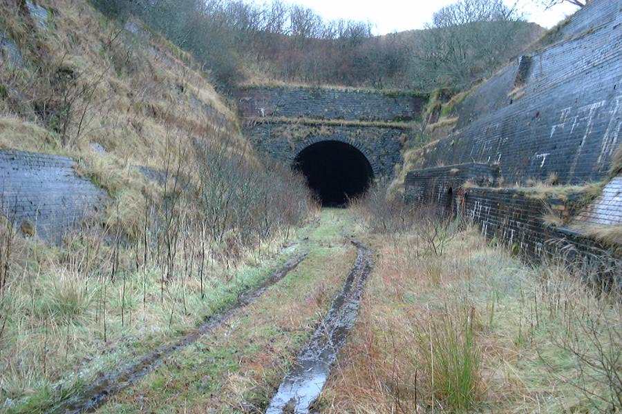
Whitrope Tunnel

The Whitrope Tunnel is a disused railway tunnel in the Scottish Borders, situated 12 miles (19 km) south of Hawick on the Waverley Route, close to Whitrope...

Waverley Route Heritage Association

Waverley Route Heritage Association is a heritage railway group involved with the history, heritage and preservation of the Waverley Route, based/centred...
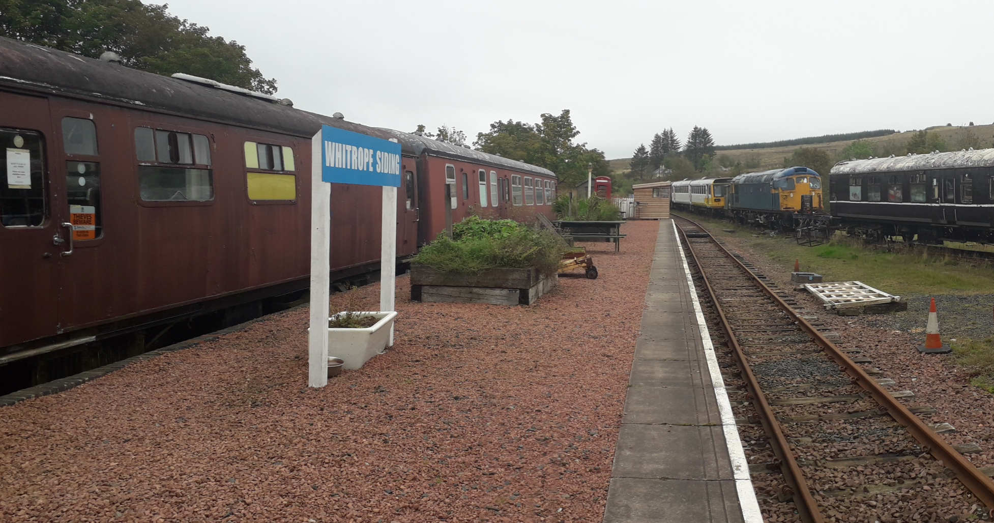
Whitrope Siding

Whitrope Siding was a trailing short siding or spur off the "up" (southbound) line, an associated trailing cross-over between up and down lines, a pair...

Whitrope

Whitrope is a densely forested, but sparsely populated area, high in the Southern Upland hills in the south central Scottish Borders in the former county...

Have you been to Capel Cleuch?

Leave your review of Capel Cleuch below (or comments, questions and feedback).