Glen Lethnot

Valley in Angus

Scotland

Glen Lethnot

Track beyond the road end A good LRT continues beyond the road end in Glen Lethnot, its purpose being to transport those who wish to shoot grouse or deer into the hills. Walkers are tolerated rather than encouraged.
Track beyond the road end Credit: Gordon Hatton

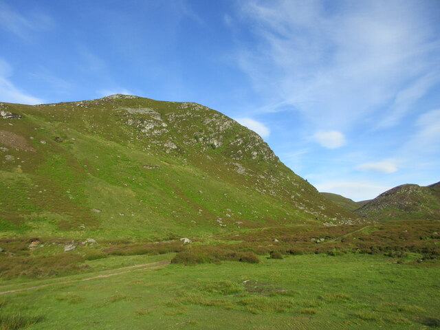
Glen Lethnot is a picturesque valley located in the county of Angus, Scotland. Situated within the Cairngorms National Park, it is known for its stunning natural beauty, tranquil atmosphere, and diverse wildlife. The valley stretches for approximately 15 kilometers, surrounded by rolling hills and dense forests, offering visitors a true sense of seclusion and escape from the hustle and bustle of urban life.

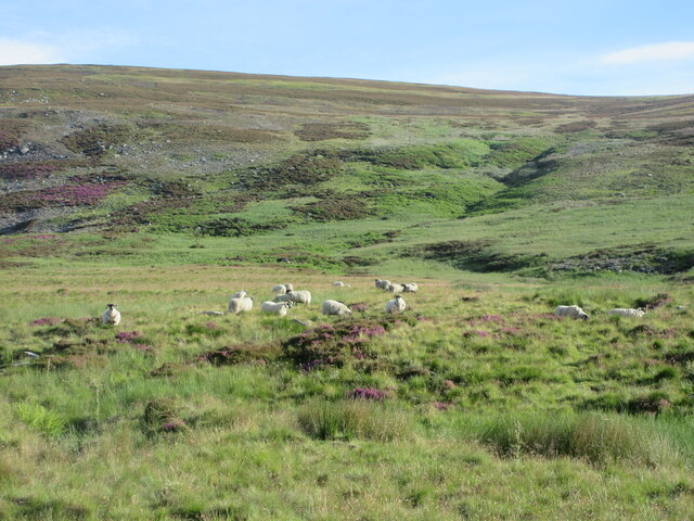
Glen Lethnot is characterized by its rugged terrain, with steep slopes and rocky outcrops that add to its dramatic landscape. The valley is traversed by a small river, the Water of Saughs, which meanders through the glen, providing a constant source of water and creating a haven for various species of birds and mammals.

The area is a haven for outdoor enthusiasts, offering a range of activities such as hiking, mountain biking, and wildlife watching. There are several walking trails that wind through the valley, allowing visitors to explore its hidden gems and experience its breathtaking views. The glen is also home to a number of rare plant species, making it a popular destination for botany enthusiasts.

In terms of amenities, Glen Lethnot is relatively isolated, with only a few scattered farms and cottages dotting the landscape. There are no major towns or villages within close proximity, adding to its sense of remoteness. However, this also means that the valley remains largely untouched and preserves its natural charm.

Overall, Glen Lethnot offers nature lovers and adventure seekers a tranquil and unspoiled retreat, providing a unique opportunity to experience the raw beauty of the Scottish countryside.

If you have any feedback on the listing, please let us know in the comments section below.

Glen Lethnot Images

Images are sourced within 2km of 56.84093/-2.8966883 or Grid Reference NO4572. Thanks to Geograph Open Source API. All images are credited.

Track beyond the road end A good LRT continues beyond the road end in Glen Lethnot, its purpose being to transport those who wish to shoot grouse or deer into the hills. Walkers are tolerated rather than encouraged.
Track beyond the road end
A good LRT continues beyond the road end in Glen Lethnot, its purpose being to transport those who wish to shoot grouse or deer into the hills. Walkers are tolerated rather than encouraged.
Bridge to Waterhead The Water of Saughs flows benath the bridge, but soon becomes the West Water, presumably after the confluence with the Burn of Corscarie.
Bridge to Waterhead
The Water of Saughs flows benath the bridge, but soon becomes the West Water, presumably after the confluence with the Burn of Corscarie.
Track above Glen Lethnot Track heading down the north side of Glen Lethnot, with Black Craig ahead on the opposite side of the glen.
Track above Glen Lethnot
Track heading down the north side of Glen Lethnot, with Black Craig ahead on the opposite side of the glen.
Black Craig Looking west towards Black Craig in Glen Lethnot.
Black Craig
Looking west towards Black Craig in Glen Lethnot.
Footbridge in Glen Lethnot Footbridge over the Water of Saughs in Glen Lethnot, with Corrie na Berran beyond.
Footbridge in Glen Lethnot
Footbridge over the Water of Saughs in Glen Lethnot, with Corrie na Berran beyond.
Sheep in Glen Lethnot Sheep on the north side of the track in Glen Lethnot.
Sheep in Glen Lethnot
Sheep on the north side of the track in Glen Lethnot.
Track in Glen Lethnot Track heading from the road end in Glen Lethnot.
Track in Glen Lethnot
Track heading from the road end in Glen Lethnot.
New road bridge at Waterhead, Glen Lethnot Replacement bridge at Waterhead.
New road bridge at Waterhead, Glen Lethnot
Replacement bridge at Waterhead.
4x4's and 8x8's Rough terrain vehicles on the Lethnot estate.
4x4's and 8x8's
Rough terrain vehicles on the Lethnot estate.
Water of Saughs Upper Glen Lethnot.
Water of Saughs
Upper Glen Lethnot.
Bridge at Waterhead The Waters of Saugh at the bridge at Waterhead
Bridge at Waterhead
The Waters of Saugh at the bridge at Waterhead
West Water/Water of Saughs The river in Glen Lethnot changes its name - somewhere.  This is near the head of the public road.
West Water/Water of Saughs
The river in Glen Lethnot changes its name - somewhere. This is near the head of the public road.
Wood above Blackhaugh A larch wood shelters Hunthill Lodge and surrounding buildings from snow laden winds off the hill.
Wood above Blackhaugh
A larch wood shelters Hunthill Lodge and surrounding buildings from snow laden winds off the hill.
Waterhead The last habitation in Glen Lethnot, still covered in snow, while every other dwelling in the glen was mostly snow free.
Waterhead
The last habitation in Glen Lethnot, still covered in snow, while every other dwelling in the glen was mostly snow free.
Road on Broom Craig A massive road runs up from near Hunthill Lodge to the electric fence on the watershed with Glen Esk just west of Black Hill's summit. There is a big ditch on one side which may be intentional, it collects snow and provides a route up to the snowfields for the estate's tracked vehicles.
Road on Broom Craig
A massive road runs up from near Hunthill Lodge to the electric fence on the watershed with Glen Esk just west of Black Hill's summit. There is a big ditch on one side which may be intentional, it collects snow and provides a route up to the snowfields for the estate's tracked vehicles.
Fence on Broom Craig Hill of Wirren and Glen Lethnot as seen from a broad ridge.
Fence on Broom Craig
Hill of Wirren and Glen Lethnot as seen from a broad ridge.
Road junction, Broom Craig Two big roads with snowfilled ditches used by tracked vehicles meet near the summit of Broom Craig. The road on the left runs down to the Mill Burn and straight on hits the tarred road near Hunthill Lodge.
Road junction, Broom Craig
Two big roads with snowfilled ditches used by tracked vehicles meet near the summit of Broom Craig. The road on the left runs down to the Mill Burn and straight on hits the tarred road near Hunthill Lodge.
Corrie na Berran An iced up crag in Glen Lethnot. In the 1990s you often had to go to 1200m on Ben Nevis to find ice, but the last few winters have brought lower crags into condition.
Corrie na Berran
An iced up crag in Glen Lethnot. In the 1990s you often had to go to 1200m on Ben Nevis to find ice, but the last few winters have brought lower crags into condition.
Show me another place!

Glen Lethnot is located at Grid Ref: NO4572 (Lat: 56.84093, Lng: -2.8966883)

Unitary Authority: Angus

Police Authority: Tayside

What 3 Words

///comic.speedy.simulator. Near Brechin, Angus

Nearby Locations

Glen Lethnot

Related Wikis

Five Glens of Angus

The Five Glens of Angus are the five Highland glens located in the western portion of the Angus region of Scotland. The five glens from westernmost to...

Angus (UK Parliament constituency)

Angus is a county constituency of the House of Commons of the Parliament of the United Kingdom (at Westminster). It elects one Member of Parliament (MP...

Loch Lee

National grid reference NO431800 Loch Lee is a loch in Angus, Scotland south of the Grampian Mountains that is fed by the Water of Lee and the Water of...

Invermark Castle

Invermark Castle is an oblong tower house dating from the 16th century, at the east of Loch Lee, Angus, Scotland. It is near the head of Glen Esk. ��2...

Have you been to Glen Lethnot?

Leave your review of Glen Lethnot below (or comments, questions and feedback).