Chapel Cleuch

Valley in Roxburghshire

Scotland

Chapel Cleuch

For Sale by Auction Slightly derelict building by the A7, labelled as 'Change House' on medium scale OS map, but not at all on the largest scale.
For Sale by Auction Credit: M J Richardson

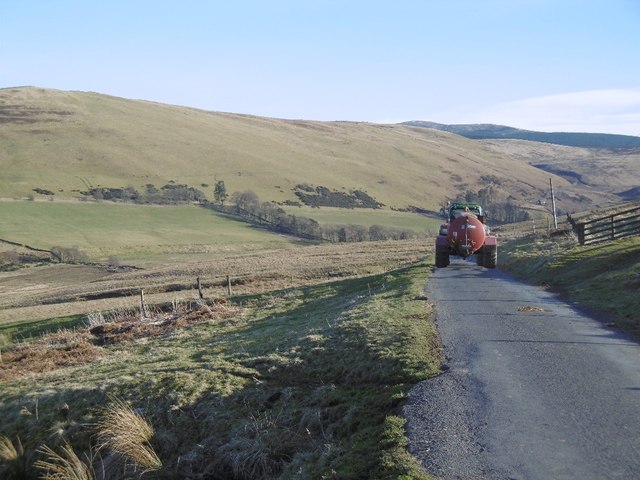
Chapel Cleuch is a picturesque valley located in Roxburghshire, Scotland. Nestled within the scenic Scottish Borders region, this charming valley offers breathtaking views and a tranquil atmosphere.

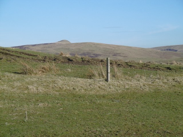
Surrounded by rolling hills and lush greenery, Chapel Cleuch is renowned for its natural beauty. The valley is home to a meandering stream that adds to its idyllic charm. The sparkling waters of the stream provide a soothing soundtrack, creating a peaceful ambiance for visitors.

Chapel Cleuch is also known for its historical significance. The valley's name is derived from the presence of a small chapel that once stood here. The ruins of the chapel still remain, serving as a reminder of the area's rich past. The chapel is believed to have been a place of worship and pilgrimage, attracting locals and travelers alike.

Nature enthusiasts are drawn to Chapel Cleuch for its diverse flora and fauna. The valley is home to a variety of plant species, including heather, wildflowers, and ancient oak trees. Wildlife such as red deer, rabbits, and various bird species can also be spotted in the area.

For outdoor enthusiasts, Chapel Cleuch offers ample opportunities for hiking and walking. There are several well-marked trails that wind through the valley, allowing visitors to explore its beauty at their own pace. These paths offer stunning vistas of the surrounding countryside and provide a chance to connect with nature.

In summary, Chapel Cleuch is a scenic and historically significant valley in Roxburghshire. Its natural beauty, tranquil atmosphere, and abundant wildlife make it a popular destination for nature lovers and those seeking a peaceful retreat.

If you have any feedback on the listing, please let us know in the comments section below.

Chapel Cleuch Images

Images are sourced within 2km of 55.352548/-2.8752949 or Grid Reference NT4406. Thanks to Geograph Open Source API. All images are credited.

For Sale by Auction Slightly derelict building by the A7, labelled as 'Change House' on medium scale OS map, but not at all on the largest scale.
For Sale by Auction
Slightly derelict building by the A7, labelled as 'Change House' on medium scale OS map, but not at all on the largest scale.
Change House, Teviotdale Derelict cottage, currently for sale by auction.
Change House, Teviotdale
Derelict cottage, currently for sale by auction.
Looking across the River Teviot Towards Teviotdale Cottage from the A7.
Looking across the River Teviot
Towards Teviotdale Cottage from the A7.
Teindside Bridge, Teviotdale Carrying the A7 over the River Teviot, with the confluence with the Northouse Burn just beyond.
Teindside Bridge, Teviotdale
Carrying the A7 over the River Teviot, with the confluence with the Northouse Burn just beyond.
Looking down Teviotdale From Tiendside Bridge on the A7.
Looking down Teviotdale
From Tiendside Bridge on the A7.
Teviotdale farmland Looking across the valley towards Broadhaugh Hill from Tiendside Bridge
Teviotdale farmland
Looking across the valley towards Broadhaugh Hill from Tiendside Bridge
Tiendside Bridge over the Teviot The A7 crosses the River Teviot.
Tiendside Bridge over the Teviot
The A7 crosses the River Teviot.
The River Teviot Looking upstream from Tiendside Bridge carrying the A7 over the river.
The River Teviot
Looking upstream from Tiendside Bridge carrying the A7 over the river.
Road, Teindside Signposted to Teindside Wetlands.
Road, Teindside
Signposted to Teindside Wetlands.
Teindside Bridge The A7 crosses the Teviot.
Teindside Bridge
The A7 crosses the Teviot.
Allan Water View downstream, out of the hills and past a rebuilt Doecleuch.
Allan Water
View downstream, out of the hills and past a rebuilt Doecleuch.
Slurry spreader Returning empty.
Slurry spreader
Returning empty.
Rough grazing, Skelfhill
Road over Doecleuch Hill Road into Skelfhill and Priesthaugh on the upper Allan Water.
Road over Doecleuch Hill
Road into Skelfhill and Priesthaugh on the upper Allan Water.
View towards Penchrise Pen From the road over Doecleuch Hill.
View towards Penchrise Pen
From the road over Doecleuch Hill.
Between Simpson's Hill and Grey Hill Open pasture upstream of Hawick.
Between Simpson's Hill and Grey Hill
Open pasture upstream of Hawick.
Simpson's Hill The road to Skelfhill from Teviotdale.
Simpson's Hill
The road to Skelfhill from Teviotdale.
Plantation on Inner Hill There is far more woodland on the left side of the road.
Plantation on Inner Hill
There is far more woodland on the left side of the road.
Show me another place!

Chapel Cleuch is located at Grid Ref: NT4406 (Lat: 55.352548, Lng: -2.8752949)

Unitary Authority: The Scottish Borders

Police Authority: The Lothians and Scottish Borders

What 3 Words

///pigs.bronzed.joyously. Near Teviothead, Scottish Borders

Nearby Locations

Chapel Cleuch

Related Wikis

Broadhaugh

Broadhaugh is a hamlet in the Scottish Borders area of Scotland, in the parish of Teviothead, in former Roxburghshire. == See also == List of places in...

Newmill-on-Teviot

Newmill-on-Teviot, commonly called Newmill, is a hamlet in the Scottish Borders, 7 kilometres (4.3 mi) south of Hawick on the River Teviot. The remains...

Teviothead

Teviothead (Scottish Gaelic: Ceann Tìbhiot) is a small village and civil parish in Teviotdale in the Scottish Borders, known locally as Teviotheid. It...

Branxholme

Branxholme is a hamlet in the Scottish Borders area of Scotland, overlooking the River Teviot, 3 miles (5 kilometres) southwest of Hawick, on the A7 road...

Nearby Amenities

Located within 500m of 55.352548,-2.8752949
Inner Hill
Ele: 309
Natural: peak
Source: NLS-OS-1st_Series
Lat/Long: 55.3556968/-2.8736104
Power: pole
Lat/Long: 55.353159/-2.8792643
Power: pole
Lat/Long: 55.3530284/-2.8784173
Power: pole
Lat/Long: 55.3528977/-2.8775661
Power: pole
Lat/Long: 55.3528747/-2.8765659
Power: pole
Lat/Long: 55.3528493/-2.8755977
Power: pole
Lat/Long: 55.3529884/-2.8743911
Power: pole
Lat/Long: 55.3531227/-2.8731951
Power: pole
Lat/Long: 55.3532292/-2.8722013
Power: pole
Lat/Long: 55.3533514/-2.8711245
Power: pole
Lat/Long: 55.3531433/-2.8697179
Power: pole
Lat/Long: 55.3529364/-2.8684325
The data included in this document is from www.openstreetmap.org. The data is made available under ODbL.

Have you been to Chapel Cleuch?

Leave your review of Chapel Cleuch below (or comments, questions and feedback).