Dry Cleuch

Valley in Peeblesshire

Scotland

Dry Cleuch

Sheep pens near Blackhopebyre
Sheep pens near Blackhopebyre Credit: Steven Brown

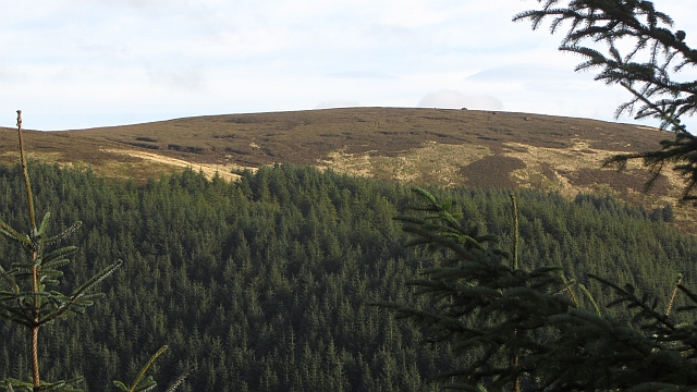
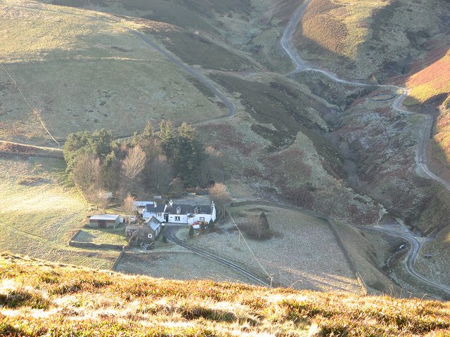
Dry Cleuch is a picturesque valley located in Peeblesshire, Scotland. Nestled amidst the rolling hills and scenic landscape, this valley offers a tranquil escape for nature lovers and outdoor enthusiasts.

The valley is characterized by its unique geological formations and diverse flora and fauna. The surrounding hills provide a stunning backdrop, with their lush greenery and rugged cliffs. The valley itself is traversed by a small river, which adds to its charm and serenity.

Dry Cleuch is a haven for wildlife, with a rich variety of species calling this place home. Visitors can spot numerous birds, including buzzards, kestrels, and various waterfowl near the river. The valley is also home to several mammal species, such as roe deer and red squirrels.

For those seeking outdoor activities, Dry Cleuch offers ample opportunities. The valley is crisscrossed by several walking trails, allowing visitors to explore the area at their own pace. Hiking enthusiasts can enjoy the breathtaking views from the top of the surrounding hills, while the river provides opportunities for fishing and canoeing.

The valley is also steeped in history, with traces of ancient settlements and ruins dotting the landscape. Archaeological enthusiasts can explore these remnants, gaining insight into the lives of past inhabitants.

Overall, Dry Cleuch is a hidden gem in Peeblesshire, offering a perfect blend of natural beauty, wildlife, outdoor activities, and historical intrigue. It is a must-visit destination for those seeking tranquility and a connection with nature.

If you have any feedback on the listing, please let us know in the comments section below.

Dry Cleuch Images

Images are sourced within 2km of 55.705362/-3.036047 or Grid Reference NT3446. Thanks to Geograph Open Source API. All images are credited.

Sheep pens near Blackhopebyre
Small plantation of trees
B709, Dewar Gill
B709, Dewar Gill
B709 near Dewar
B709 near Dewar
Head of South Grain The start of one of the steep sided glens running down to the Leithen Water. The sheltered ground is planted with conifers, while the going on the moorland is abominable.
Head of South Grain
The start of one of the steep sided glens running down to the Leithen Water. The sheltered ground is planted with conifers, while the going on the moorland is abominable.
Head of South Grain Peat bog and moorland on the Moorfoot Hills, appalling going underfoot.
Head of South Grain
Peat bog and moorland on the Moorfoot Hills, appalling going underfoot.
Middle Hill View of Middle Hill from the west.
Middle Hill
View of Middle Hill from the west.
Moorfoot Hills Hill country near Blackhopebyres. The slopes are well drained, but above is a big area of bog.
Moorfoot Hills
Hill country near Blackhopebyres. The slopes are well drained, but above is a big area of bog.
B709, Moorfoot Hills The road is heading for a distinct pass between the headwaters of the Heriot Water and Leithen Waters. Once through the gap the road widens.
B709, Moorfoot Hills
The road is heading for a distinct pass between the headwaters of the Heriot Water and Leithen Waters. Once through the gap the road widens.
Pass, Moorfoot Hills The B709 makes use of a break in the peaty plateau between Heriot and Innerleithen.
Pass, Moorfoot Hills
The B709 makes use of a break in the peaty plateau between Heriot and Innerleithen.
Kitty's Cleuch Stell and tree beside a Moorfoot Hills burn.
Kitty's Cleuch
Stell and tree beside a Moorfoot Hills burn.
Middle Burn Upstream of Blackhopebyre and beside the B709 in the Moorfoot Hills.
Middle Burn
Upstream of Blackhopebyre and beside the B709 in the Moorfoot Hills.
Dewar Gill A high pass in the middle of the Moorfoot Hills with the B709 between Heriot and Innerleithen.
Dewar Gill
A high pass in the middle of the Moorfoot Hills with the B709 between Heriot and Innerleithen.
B709, Dewar A long straight road, high in the Moorfoot Hills.
B709, Dewar
A long straight road, high in the Moorfoot Hills.
Dewar Hill Steep heather slopes above the B709.
Dewar Hill
Steep heather slopes above the B709.
B709, Dewar Approaching the pass at Dewar Gill.
B709, Dewar
Approaching the pass at Dewar Gill.
Road through the hills to Innerleithen The narrow pass through which the B709 heads south to the Leithen Water and Innerleithen.
Road through the hills to Innerleithen
The narrow pass through which the B709 heads south to the Leithen Water and Innerleithen.
Gill Cleuch The S arm of the deeply cut cleuch on the steep sides of Eastside Heights. After taking this I spotted a roe deer making its way around the hillside, and later saw several hares on the moorland above.
Gill Cleuch
The S arm of the deeply cut cleuch on the steep sides of Eastside Heights. After taking this I spotted a roe deer making its way around the hillside, and later saw several hares on the moorland above.
Show me another place!

Dry Cleuch is located at Grid Ref: NT3446 (Lat: 55.705362, Lng: -3.036047)

Unitary Authority: The Scottish Borders

Police Authority: The Lothians and Scottish Borders

What 3 Words

///slimmer.verb.kidney. Near Innerleithen, Scottish Borders

Nearby Locations

Dry Cleuch

Related Wikis

Dewar, Scottish Borders

Dewar is a fermtoun by the Dewar Burn and Peatrig Hill, in the Scottish Borders area of Scotland.Places nearby include Allanshaugh, Borthwick Hall, Fountainhall...

Peatrig Hill

Peatrig Hill is a minor hill in Scotland, located about 15 km south-southeast of Edinburgh. One of the Moorfoot Hills, it is located in the parish of Heriot...

Windlestraw Law

Windlestraw Law is a hill in the Moorfoot Hills range, part of the Southern Uplands of Scotland. It is the highest peak of the range, and lies north of...

Blackhope Scar

Blackhope Scar is a hill in the Moorfoot Hills range, part of the Southern Uplands of Scotland. It lies to the northeast of the town of Peebles and is...

Nearby Amenities

Located within 500m of 55.705362,-3.036047
Bench
Backrest: yes
Lat/Long: 55.7086699/-3.0386132
The data included in this document is from www.openstreetmap.org. The data is made available under ODbL.

Have you been to Dry Cleuch?

Leave your review of Dry Cleuch below (or comments, questions and feedback).