Coire Ranaich

Valley in Banffshire

Scotland

Coire Ranaich

Summit Monadh an t-Sluichd Leith A small cairn on the summit of Monadh an t-Sluichd Leith 800m (Corbett Top).
Summit Monadh an t-Sluichd Leith Credit: Ralph Greig

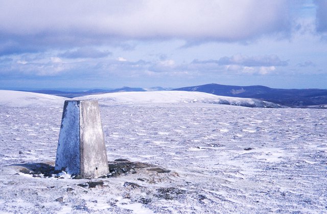
Coire Ranaich is a picturesque valley located in the region of Banffshire, Scotland. Nestled amidst the majestic Cairngorm Mountains, this valley is characterized by its stunning natural beauty and diverse landscape.

The valley stretches for approximately 5 miles and is enveloped by rugged mountain peaks, including the prominent Cairn Liath and Ben Rinnes. Coire Ranaich is renowned for its breathtaking scenery, with its rolling hills, lush green meadows, and crystal-clear streams that meander through the valley.

One of the notable features of Coire Ranaich is its rich biodiversity. The valley is home to a wide array of flora and fauna, making it a popular destination for nature enthusiasts and birdwatchers. Visitors can spot various species of birds, including golden eagles, ptarmigans, and red grouse, while exploring the valley's trails and paths.

Furthermore, Coire Ranaich offers a range of outdoor activities for adventurers. The valley provides ample opportunities for hiking, mountain biking, and even winter sports during the colder months. There are several well-marked trails that cater to different difficulty levels, allowing both beginners and seasoned hikers to enjoy the valley's scenic beauty.

In addition to its natural wonders, Coire Ranaich also boasts a rich cultural heritage. The valley is dotted with ancient ruins, stone circles, and burial sites, providing a glimpse into the area's fascinating history.

Overall, Coire Ranaich is a captivating destination that offers a harmonious blend of stunning landscapes, abundant wildlife, and historical charm. Whether seeking tranquility amidst nature or an exhilarating outdoor adventure, this valley in Banffshire is sure to leave visitors with lasting memories.

If you have any feedback on the listing, please let us know in the comments section below.

Coire Ranaich Images

Images are sourced within 2km of 57.233377/-3.2465434 or Grid Reference NJ2416. Thanks to Geograph Open Source API. All images are credited.

Summit Monadh an t-Sluichd Leith A small cairn on the summit of Monadh an t-Sluichd Leith 800m (Corbett Top).
Summit Monadh an t-Sluichd Leith
A small cairn on the summit of Monadh an t-Sluichd Leith 800m (Corbett Top).
Peat bogs in the Ladder hills Ground conditions in the area here are peat bogs
Peat bogs in the Ladder hills
Ground conditions in the area here are peat bogs
At a grouse butt above Clash of Scalan A panoramic view of the Braes of Glenlivet, with part of the wooden grouse butt visible in the foreground.
At a grouse butt above Clash of Scalan
A panoramic view of the Braes of Glenlivet, with part of the wooden grouse butt visible in the foreground.
Cairn on the Ladder Hills On an unnamed section of hillside north-east of Carn Dulack. The Braes of Glenlivet are visible below.
Cairn on the Ladder Hills
On an unnamed section of hillside north-east of Carn Dulack. The Braes of Glenlivet are visible below.
Hillwalkers on the Ladder Hills Quick progress can be made across the crisp, lichen-rich, wind-clipped plateau here, but there are some sections of peat hags and bogs elsewhere in these hills.
Hillwalkers on the Ladder Hills
Quick progress can be made across the crisp, lichen-rich, wind-clipped plateau here, but there are some sections of peat hags and bogs elsewhere in these hills.
Fair-weather cloud above Carn Dulack Heather moorland and crisp, lichen-rich, wind-clipped vegetation on the Ladder Hills.
Fair-weather cloud above Carn Dulack
Heather moorland and crisp, lichen-rich, wind-clipped vegetation on the Ladder Hills.
Gap in the fence below Carn Dulack Looking through the gap towards the Braes of Glenlivet.
Gap in the fence below Carn Dulack
Looking through the gap towards the Braes of Glenlivet.
Parking area for Lecht Mine
Coire Buidhe
Coire Buidhe
Lecht Mine
Lecht Mine
The Lecht Mine At the head of the Conglass a vein of Manganese containing 20-40% iron runs for a distance of three miles along a fault. From 1736 to 1739 this was worked for Iron Ore by the York Buildings Company. One of the Company’s operations was the purchase and floating of timber down the Spey. They looked to other enterprises and the manufacture of Iron was considered. However, fuel other than peat was scarce in the district and this necessitated the transport of the Iron Ore on pack horses over the river Avon at Fordmouth to Culnakyle in Abernethy where it was smelted using wood. To produce “Stradoun Pigs”. This phrase in the company papers caused historians some confusion as it is the old name for Strathavon. It was soon evident that the distance that the ore had to be transported made the scheme unviable and the operation collapsed.

In 1841 on the initiative of a local man, the mine was reopened for the extraction of Manganese. For the first year the Duke of Richmond & Gordon kept the business in his own hands employing 12 men to dig and 15 boys to crush the ore. Thereafter the production was put in the hands of a Newcastle firm and a mill, the current building, was erected to process the ore, probably in 1842.

There were two pairs of wheels, in the mill, one being 25 feet in diameter and another weighing a ton. These were made in Aberdeen and had to be brought across the Lecht. Apparently the local minister’s bull had to be used to assist the horses in pulling the wheels up the Lecht but sadly this was also to be a short lived venture.

Mining continued for six years with the shaft reaching a depth of 85 feet. £1 per ton was paid for carting the material to Speymouth where it was shipped to Newcastle for use in bleaching. However, the discovery of new bleaching agents and the availability of cheap Manganese from Russia brought the price down (from £8 to £3 per ton) to such a level that the mine, which had employed 63 people at its peak, was forced to close.

The building was substantially restored and re-roofed in 1983 by Moray Council. Much of the information above comes from "Tomintoul, its Glens and People" by Victor Gaffney.
The Lecht Mine
At the head of the Conglass a vein of Manganese containing 20-40% iron runs for a distance of three miles along a fault. From 1736 to 1739 this was worked for Iron Ore by the York Buildings Company. One of the Company’s operations was the purchase and floating of timber down the Spey. They looked to other enterprises and the manufacture of Iron was considered. However, fuel other than peat was scarce in the district and this necessitated the transport of the Iron Ore on pack horses over the river Avon at Fordmouth to Culnakyle in Abernethy where it was smelted using wood. To produce “Stradoun Pigs”. This phrase in the company papers caused historians some confusion as it is the old name for Strathavon. It was soon evident that the distance that the ore had to be transported made the scheme unviable and the operation collapsed. In 1841 on the initiative of a local man, the mine was reopened for the extraction of Manganese. For the first year the Duke of Richmond & Gordon kept the business in his own hands employing 12 men to dig and 15 boys to crush the ore. Thereafter the production was put in the hands of a Newcastle firm and a mill, the current building, was erected to process the ore, probably in 1842. There were two pairs of wheels, in the mill, one being 25 feet in diameter and another weighing a ton. These were made in Aberdeen and had to be brought across the Lecht. Apparently the local minister’s bull had to be used to assist the horses in pulling the wheels up the Lecht but sadly this was also to be a short lived venture. Mining continued for six years with the shaft reaching a depth of 85 feet. £1 per ton was paid for carting the material to Speymouth where it was shipped to Newcastle for use in bleaching. However, the discovery of new bleaching agents and the availability of cheap Manganese from Russia brought the price down (from £8 to £3 per ton) to such a level that the mine, which had employed 63 people at its peak, was forced to close. The building was substantially restored and re-roofed in 1983 by Moray Council. Much of the information above comes from "Tomintoul, its Glens and People" by Victor Gaffney.
Looking towards the Lecht Mine The building dates from 1841 or so, and was the crushing plant for a manganese mine. It carried a water wheel and heavy machinery, all now gone.
Looking towards the Lecht Mine
The building dates from 1841 or so, and was the crushing plant for a manganese mine. It carried a water wheel and heavy machinery, all now gone.
The Lecht mine Those clumps of shrub which you see in the foreground and leading to the mine are Juniper as used in the production of gin.
The Lecht mine
Those clumps of shrub which you see in the foreground and leading to the mine are Juniper as used in the production of gin.
The cold comfort of the Lecht mine Here the hard, sharp-edged "development" clashes harshly with the rolling, undulating, surroundings.
The cold comfort of the Lecht mine
Here the hard, sharp-edged "development" clashes harshly with the rolling, undulating, surroundings.
Lecht Mine It is hard to believe that men worked mining various ores in this rugged environment in the mid 1700s and 1800s.
Lecht Mine
It is hard to believe that men worked mining various ores in this rugged environment in the mid 1700s and 1800s.
Ladder Hills above Scalan
Crushing House at Lecht Ironstone and Manganese Mine Reconstructed mid 19th century ore crushing house. <span class="nowrap"><a title="https://canmore.org.uk/site/74949/lecht-ironstone-mine" rel="nofollow ugc noopener" href="https://canmore.org.uk/site/74949/lecht-ironstone-mine">Link</a><img style="margin-left:2px;" alt="External link" title="External link - shift click to open in new window" src="https://s1.geograph.org.uk/img/external.png" width="10" height="10"/></span>
Crushing House at Lecht Ironstone and Manganese Mine
Reconstructed mid 19th century ore crushing house. LinkExternal link
Well Of The Lecht A stone panel beside a natural spring to commemorate the building of the military road through this area in 1754. <span class="nowrap"><a title="https://canmore.org.uk/site/16294/well-of-the-lecht" rel="nofollow ugc noopener" href="https://canmore.org.uk/site/16294/well-of-the-lecht">Link</a><img style="margin-left:2px;" alt="External link" title="External link - shift click to open in new window" src="https://s1.geograph.org.uk/img/external.png" width="10" height="10"/></span>
Well Of The Lecht
A stone panel beside a natural spring to commemorate the building of the military road through this area in 1754. LinkExternal link
Show me another place!

Coire Ranaich is located at Grid Ref: NJ2416 (Lat: 57.233377, Lng: -3.2465434)

Unitary Authority: Moray

Police Authority: North East

What 3 Words

///procured.rental.zapped. Near Ballater, Aberdeenshire

Nearby Locations

Coire Ranaich Coire Buidhe

Related Wikis

Ladder Hills

The Ladder Hills (Scottish Gaelic: Monadh an Fhàraidh) are a range of hills in northeast Scotland which straddle the border between Aberdeenshire and Moray...

Càrn Mòr (Ladder Hills)

Càrn Mòr (804 m) is the highest mountain of the Ladder Hills on the border of Aberdeenshire and Moray, Scotland. It is located northeast of the Cairngorm...

Scalan

The Scalan was once a seminary and was one of the few places in Scotland where the Roman Catholic faith was kept alive during the troubled times of the...

West Aberdeenshire and Kincardine (UK Parliament constituency)

West Aberdeenshire and Kincardine is a county constituency of the House of Commons of the Parliament of the United Kingdom of Great Britain and Northern...

Braeval distillery

Braeval distillery is a distiller of Scotch whisky in Chapeltown, Banffshire, Scotland. Founded in 1973 as Braes of Glenlivet, the distillery is owned...

Clashnoir

Clashnoir is a settlement in Glenlivet, Moray, Scotland, 92 miles north of Edinburgh and 25 miles south of Elgin.
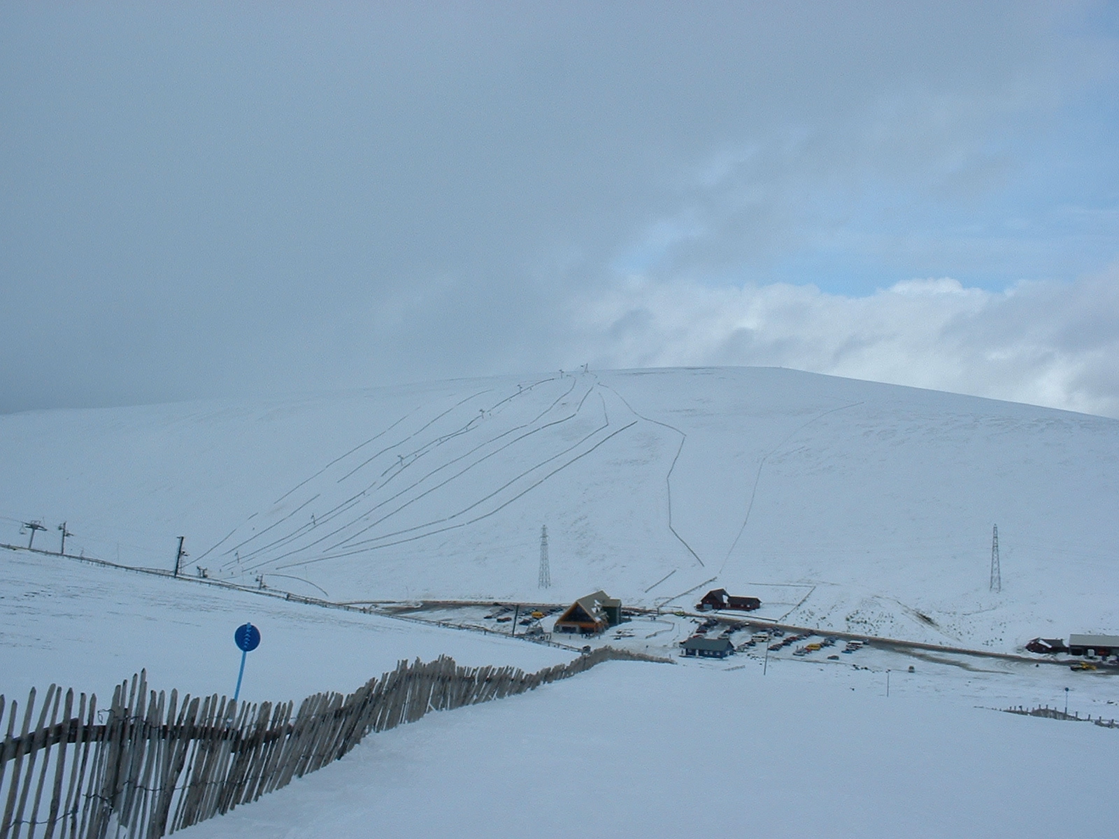
Lecht Ski Centre

The Lecht Ski Centre is an alpine ski area in the Cairngorms in the Scottish Highlands. The ski slopes are set around the mountains Beinn a' Chruinnich...

Auchnarrow

Auchnarrow (Scottish Gaelic: Achadh an Arbha) is a village in Moray, Scotland.

Have you been to Coire Ranaich?

Leave your review of Coire Ranaich below (or comments, questions and feedback).