Kilry Glen

Valley in Angus

Scotland

Kilry Glen

Cateran Trail and Knowehead For some reason, the Cateran Trail runs along the right side of the fields visible in the foreground of this image, down to the minor road. Knowehead is on the left, Mid Derry on the right. Instead of climbing several fences and dealing with a bunch of cows, it may just be much easier to continue above the fields to the west a little while longer until the field above Kilry Ecopods, which can easily be traversed.
Cateran Trail and Knowehead Credit: Aleks Scholz

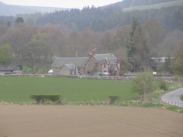
Kilry Glen, also known as Angus Valley, is a picturesque area located in Angus, Scotland. Nestled between rolling hills and dense woodlands, the glen offers a tranquil and scenic escape from the hustle and bustle of everyday life.

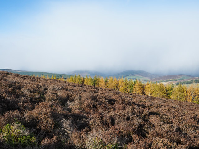
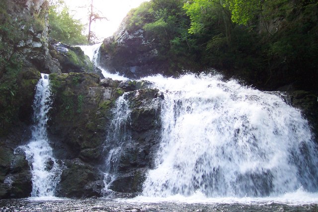
The glen is characterized by its stunning natural beauty, with a lush green landscape dotted with wildflowers and ancient trees. A small river meanders through the valley, adding to its charm and providing a calming soundtrack for visitors. The river is known for its crystal-clear waters, which attract a variety of wildlife, including otters, herons, and even the occasional salmon.

Kilry Glen is a popular destination for nature enthusiasts and hikers, offering a network of well-marked trails that allow visitors to explore the area's stunning surroundings. The trails vary in difficulty, catering to both casual walkers and experienced hikers. Along the way, visitors can discover hidden waterfalls, panoramic viewpoints, and abundant wildlife.

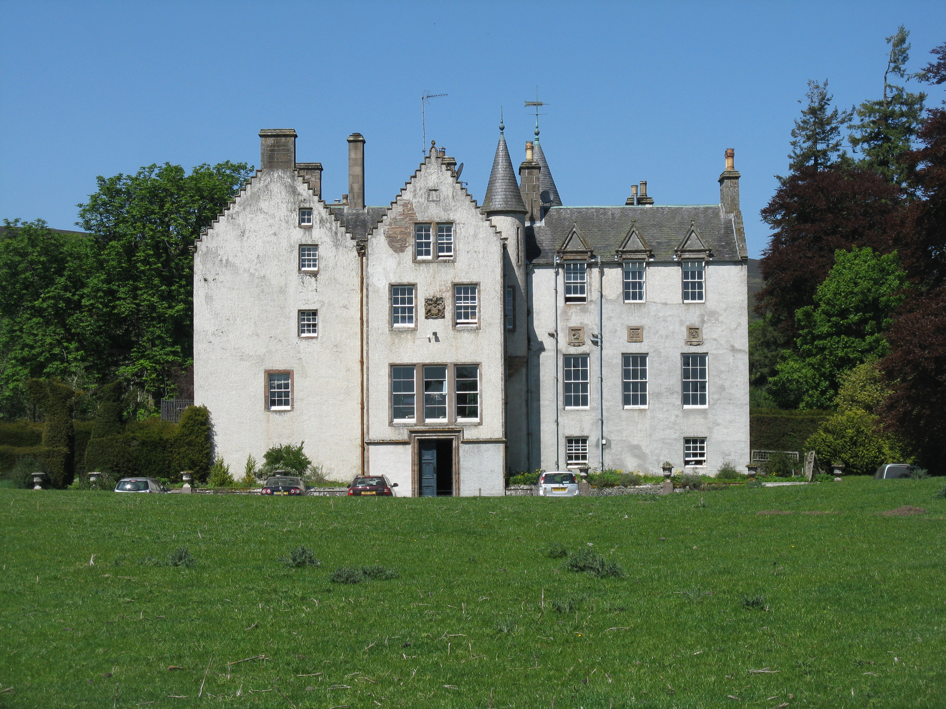
In addition to its natural beauty, Kilry Glen is also steeped in history. The area is home to several ancient archaeological sites, including standing stones and burial mounds, which provide fascinating insights into the region's past.

For those seeking a peaceful retreat, Kilry Glen offers a range of accommodation options, including cozy cottages and charming bed and breakfasts. Visitors can relax and unwind in the tranquil surroundings, immersing themselves in the beauty of nature.

Overall, Kilry Glen, Angus is a captivating destination that showcases the best of Scotland's natural beauty. Whether it's exploring the trails, admiring the wildlife, or simply taking in the serenity of the glen, visitors are sure to be captivated by its enchanting allure.

If you have any feedback on the listing, please let us know in the comments section below.

Kilry Glen Images

Images are sourced within 2km of 56.67957/-3.2640313 or Grid Reference NO2254. Thanks to Geograph Open Source API. All images are credited.

Cateran Trail and Knowehead For some reason, the Cateran Trail runs along the right side of the fields visible in the foreground of this image, down to the minor road. Knowehead is on the left, Mid Derry on the right. Instead of climbing several fences and dealing with a bunch of cows, it may just be much easier to continue above the fields to the west a little while longer until the field above Kilry Ecopods, which can easily be traversed.
Cateran Trail and Knowehead
For some reason, the Cateran Trail runs along the right side of the fields visible in the foreground of this image, down to the minor road. Knowehead is on the left, Mid Derry on the right. Instead of climbing several fences and dealing with a bunch of cows, it may just be much easier to continue above the fields to the west a little while longer until the field above Kilry Ecopods, which can easily be traversed.
Balduff Hill Seen from the minor road near Little Kilry.
Balduff Hill
Seen from the minor road near Little Kilry.
Small loch A gravel path leads from the minor road over Kilry Hill to Islaview Cottage. This lochan is about halfway on this path. The Cateran Trail cuts over this track at this point, although it is difficult to discern what exactly it is doing around here.
Small loch
A gravel path leads from the minor road over Kilry Hill to Islaview Cottage. This lochan is about halfway on this path. The Cateran Trail cuts over this track at this point, although it is difficult to discern what exactly it is doing around here.
View across the valley At the bottom of the glen is the Kilry burn. In this picture are Wester Derry (on the right), Burnside and Cottertown (left of centre), and Little Kilry (right of centre). Picture taken at half past eight on a mid June evening.
View across the valley
At the bottom of the glen is the Kilry burn. In this picture are Wester Derry (on the right), Burnside and Cottertown (left of centre), and Little Kilry (right of centre). Picture taken at half past eight on a mid June evening.
Slumping beside the Burn of Kilry After prolonged heavy rain.
Slumping beside the Burn of Kilry
After prolonged heavy rain.
The track to Over Drumhead A wind turbine on Balduff Hill on the left.
The track to Over Drumhead
A wind turbine on Balduff Hill on the left.
Deer on Balduff Hill Single deer on the eastern flank of Balduff Hill.
Deer on Balduff Hill
Single deer on the eastern flank of Balduff Hill.
Pillar on Balduff Hill Approaching the trig pillar on the flat summit of Balduff Hill.
Pillar on Balduff Hill
Approaching the trig pillar on the flat summit of Balduff Hill.
Trig pillar, Balduff Hill The triangulation pillar on the summit of Balduff Hill, looking south-east.
Trig pillar, Balduff Hill
The triangulation pillar on the summit of Balduff Hill, looking south-east.
Sheared sheep Recently sheared sheep near Easter Derry.
Sheared sheep
Recently sheared sheep near Easter Derry.
Mid Derry Mid Derry Farm with unusual sign.
Mid Derry
Mid Derry Farm with unusual sign.
Kilry Primary School The school at Kilry from the south.
Kilry Primary School
The school at Kilry from the south.
Hill of Fernyhirst The Hill of Fernyhirst viewed from the Druim Dearg road to the east.
Hill of Fernyhirst
The Hill of Fernyhirst viewed from the Druim Dearg road to the east.
Little Kilry Little Kilry farm, viewed from the north with Balduff Hill beyond.
Little Kilry
Little Kilry farm, viewed from the north with Balduff Hill beyond.
Dalkilry House Dilapidated house at Dalkilry, viewed from the south.
Dalkilry House
Dilapidated house at Dalkilry, viewed from the south.
Cateran Trail heading north The Cateran Trail heading northwards through woodland between Kilry and the Kirkton of Glenisla.
Cateran Trail heading north
The Cateran Trail heading northwards through woodland between Kilry and the Kirkton of Glenisla.
Heather on northern slope of Balduff Hill Sunshine on the heather and on the golden larch trees beyond but with a shower approaching from the north.
(The shower passed over swiftly and for the first time for us in the 'winter' of 2018 / 2019, there were snowflakes mixed in with the raindrops.)
Heather on northern slope of Balduff Hill
Sunshine on the heather and on the golden larch trees beyond but with a shower approaching from the north. (The shower passed over swiftly and for the first time for us in the 'winter' of 2018 / 2019, there were snowflakes mixed in with the raindrops.)
Knaptam Hill The wooded dome of Knaptam Hill seen across the shallow valley separating it from Ardormie Hill; both hills are lesser features on ridges of the more significant Balduff Hill.
Knaptam Hill
The wooded dome of Knaptam Hill seen across the shallow valley separating it from Ardormie Hill; both hills are lesser features on ridges of the more significant Balduff Hill.
Show me another place!

Kilry Glen is located at Grid Ref: NO2254 (Lat: 56.67957, Lng: -3.2640313)

Unitary Authority: Angus

Police Authority: Tayside

What 3 Words

///slicing.outlawing.soccer. Near Alyth, Perth & Kinross

Nearby Locations

Kilry Glen

Related Wikis

Kilry Glen

Kilry Glen, in Angus, Scotland, is the glen of the Burn of Kilry, a tributary of the River Isla. It is situated west of the B954 road, approximately four...

Bridge of Craigisla

Bridge of Craigisla is a hamlet in Angus, Scotland. The bridge crosses the River Isla. This settlement lies along the B954 road. == References ==

Bamff

Bamff House is the home of the Ramsays of Bamff, and is located within a 1,300-acre (5.3 km2) estate in Perthshire, Scotland. Bamff House began as a fortified...

Backwater Reservoir

Backwater Reservoir is a reservoir in north west Angus, Scotland. The reservoir's sole purpose is to provide drinking water, and as such, it supplies Angus...

Nearby Amenities

Located within 500m of 56.67957,-3.2640313
Little Kilry Farm
Local Ref: AT
Naptan AtcoCode: 6490IM1779
Naptan Bearing: NW
Naptan BusStopType: CUS
Naptan CommonName: Little Kilry Farm
Naptan Indicator: at
Naptan NaptanCode: 26427365
Naptan Street: Unclassified Road
Naptan Verified: no
Source: naptan_import
Lat/Long: 56.6833636/-3.2637994
Little Kilry
Place: isolated_dwelling
Lat/Long: 56.683256/-3.2642229
Burnside
Place: isolated_dwelling
Lat/Long: 56.6778763/-3.2635881
Power: pole
Lat/Long: 56.6821124/-3.2574573
Power: pole
Lat/Long: 56.6815499/-3.2575566
Power: pole
Lat/Long: 56.6807941/-3.2577235
Power: pole
Lat/Long: 56.6798438/-3.2579175
Power: pole
Lat/Long: 56.6791425/-3.2581182
Power: pole
Lat/Long: 56.6784164/-3.2583189
Power: pole
Lat/Long: 56.677782/-3.2578069
Power: pole
Lat/Long: 56.6771574/-3.2573107
Power: pole
Lat/Long: 56.6773198/-3.2585197
Power: pole
Lat/Long: 56.6774635/-3.2597422
Power: pole
Lat/Long: 56.6777175/-3.261876
Power: pole
Lat/Long: 56.6778377/-3.2628234
Power: pole
Lat/Long: 56.6753805/-3.2612997
Power: pole
Lat/Long: 56.6757039/-3.2611869
Power: pole
Lat/Long: 56.6761401/-3.2610178
Power: pole
Lat/Long: 56.6766221/-3.2608283
Power: pole
Lat/Long: 56.6824754/-3.2701642
Power: pole
Lat/Long: 56.6827827/-3.2690364
Power: pole
Lat/Long: 56.6830627/-3.2679989
Power: pole
Lat/Long: 56.6833476/-3.2669816
Power: pole
Lat/Long: 56.6835855/-3.266156
Power: pole
Lat/Long: 56.6835446/-3.2652335
Power: pole
Lat/Long: 56.6835112/-3.2643019
Power: pole
Lat/Long: 56.6834566/-3.2627456
Power: pole
Lat/Long: 56.6834046/-3.2614328
Power: pole
Lat/Long: 56.6833538/-3.2599825
Power: pole
Lat/Long: 56.6839702/-3.264011
The data included in this document is from www.openstreetmap.org. The data is made available under ODbL.

Have you been to Kilry Glen?

Leave your review of Kilry Glen below (or comments, questions and feedback).