Cons Cleuch

Valley in Peeblesshire

Scotland

Cons Cleuch

Track to the col between Deer Law and Conscleuch Head Looking towards Conscleuch Head and Black Law.
Track to the col between Deer Law and Conscleuch Head Credit: wrobison

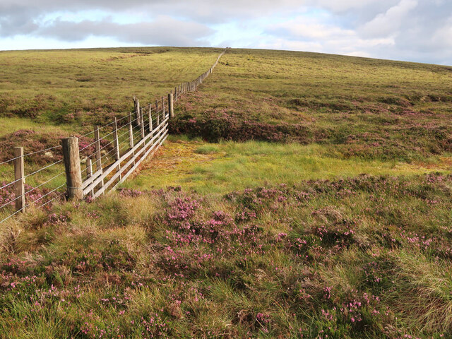
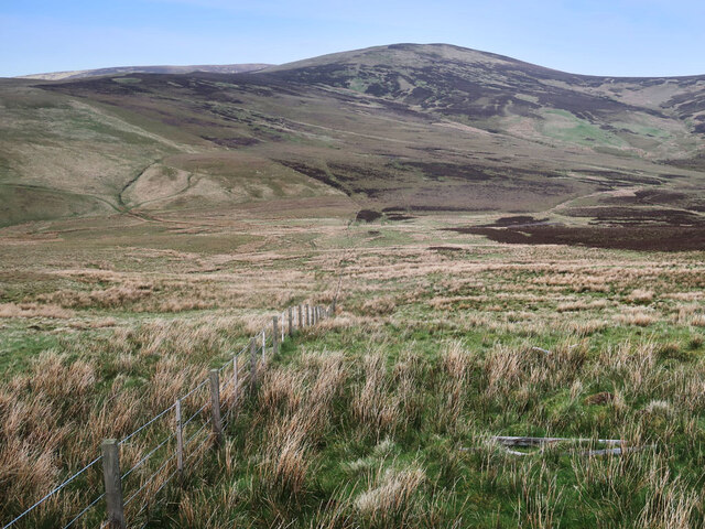
Cons Cleuch is a picturesque valley located in Peeblesshire, Scotland. It is situated in the southern part of the country, nestled within the scenic Scottish Borders region. The valley is renowned for its natural beauty and is a popular destination for outdoor enthusiasts and nature lovers.

Cons Cleuch is characterized by its rolling hills, lush greenery, and diverse wildlife. The valley is home to a variety of plant species, including heather, gorse, and ferns, which create a vibrant and colorful landscape. The area is also known for its meandering streams and small waterfalls, adding to its charm and tranquility.

The valley offers a range of activities for visitors to enjoy. Hiking and walking trails are abundant, allowing individuals to explore the area's stunning scenery at their own pace. The trails lead to various viewpoints, allowing for breathtaking panoramic vistas of the surrounding countryside.

Cons Cleuch is also popular for birdwatching, with a wide array of bird species making their home in the valley. Visitors may spot birds such as red grouse, skylarks, and buzzards during their visit. Additionally, the valley is home to several species of mammals, including deer, hares, and badgers.

For those seeking a peaceful retreat, Cons Cleuch offers a tranquil and idyllic setting. The valley's peaceful atmosphere, coupled with its natural beauty, makes it the perfect place to unwind and connect with nature. Whether it be a leisurely stroll along the trails or a picnic by the streams, Cons Cleuch offers a serene escape from the hustle and bustle of everyday life.

If you have any feedback on the listing, please let us know in the comments section below.

Cons Cleuch Images

Images are sourced within 2km of 55.510722/-3.2399663 or Grid Reference NT2124. Thanks to Geograph Open Source API. All images are credited.

Track to the col between Deer Law and Conscleuch Head Looking towards Conscleuch Head and Black Law.
Track to the col between Deer Law and Conscleuch Head
Looking towards Conscleuch Head and Black Law.
Moorland on Deer Law Megget Reservoir in the distance.
Moorland on Deer Law
Megget Reservoir in the distance.
Moorland on Conscleuch Head Looking towards Layer Knowe.
Moorland on Conscleuch Head
Looking towards Layer Knowe.
Fence and bog between Black Law and Conscleuch Head A good fence and an area of bog to be avoided.
Fence and bog between Black Law and Conscleuch Head
A good fence and an area of bog to be avoided.
Low water in the Megget Reservoir This reservoir - the main one supplying Edinburgh - is at a seriously low level after an extended dry spell.
Low water in the Megget Reservoir
This reservoir - the main one supplying Edinburgh - is at a seriously low level after an extended dry spell.
A signpost at Henderland This lichen-covered signpost giving directions to Cockburn’s Grave at Chapelhope is on the north side of the road at Henderland. For more information on Cockburn’s Tomb, see <a href="https://www.geograph.org.uk/photo/1257004">NT2323 : An information plaque at Cockburn's Tomb</a> and <a href="https://www.geograph.org.uk/photo/6429365">NT2323 : Cockburn's Tombe on Chapel Knowe</a>.
A signpost at Henderland
This lichen-covered signpost giving directions to Cockburn’s Grave at Chapelhope is on the north side of the road at Henderland. For more information on Cockburn’s Tomb, see NT2323 : An information plaque at Cockburn's Tomb and NT2323 : Cockburn's Tombe on Chapel Knowe.
Craigie Rig This is an area of rough grazing with patches of heather. The high hill in the background is Cramalt Craig.
Craigie Rig
This is an area of rough grazing with patches of heather. The high hill in the background is Cramalt Craig.
Boulders on the lower northern slopes of Bridge End Hill There are little outcrops and boulders in this area grazed by sheep. Bracken will be a problem in the summer months. The hill in the background is Broomy Law.
Boulders on the lower northern slopes of Bridge End Hill
There are little outcrops and boulders in this area grazed by sheep. Bracken will be a problem in the summer months. The hill in the background is Broomy Law.
How Cleuch This telephoto shot towards How Cleuch on Broomy Law was taken from Syart Rig.
How Cleuch
This telephoto shot towards How Cleuch on Broomy Law was taken from Syart Rig.
Moorland fence on Foulbrig Looking towards Black Law.
Moorland fence on Foulbrig
Looking towards Black Law.
Megget Dam On Megget Dam looking towards the slopes of Syart Law.
Megget Dam
On Megget Dam looking towards the slopes of Syart Law.
The draw-off and overflow tower at Megget Reservoir The reservoir was opened on 30th September 1983 and under normal conditions has an area of surface water of 259 hectares (640 acres).
The draw-off and overflow tower at Megget Reservoir
The reservoir was opened on 30th September 1983 and under normal conditions has an area of surface water of 259 hectares (640 acres).
A frozen pool at Craigie Rig Broomy Law is the hill in the background.
A frozen pool at Craigie Rig
Broomy Law is the hill in the background.
An access track above the Glengaber Burn The steep hill on the right is Broomy Law in winter colours. For the same view in June taken by Jim Barton, see <a href="https://www.geograph.org.uk/photo/6194118">NT2123 : Track in Glen Gaber</a>.
An access track above the Glengaber Burn
The steep hill on the right is Broomy Law in winter colours. For the same view in June taken by Jim Barton, see NT2123 : Track in Glen Gaber.
A commemorative stone at Glenagaber The stone is inscribed as follows:-

2013
SET HERE TO MARK
150 YEARS OF PARTNERSHIP
BETWEEN
THE WEMYSS AND MARCH ESTATES
AND THE MITCHELL FAMILY
TENANTS IN HENDERLAND
SINCE 1863
A commemorative stone at Glenagaber
The stone is inscribed as follows:- 2013 SET HERE TO MARK 150 YEARS OF PARTNERSHIP BETWEEN THE WEMYSS AND MARCH ESTATES AND THE MITCHELL FAMILY TENANTS IN HENDERLAND SINCE 1863
The Glengaber Burn
The Glengaber Burn
Outflow from dam Start of the outflow from dam.
Outflow from dam
Start of the outflow from dam.
Megget Reservoir Stilling Pool A view of the stilling pool at the start of the outflow from Megget Reservoir.  Access roads to the control building can be noted on the left.  In the distance, a small part of St Mary's Loch is visible.
Megget Reservoir Stilling Pool
A view of the stilling pool at the start of the outflow from Megget Reservoir. Access roads to the control building can be noted on the left. In the distance, a small part of St Mary's Loch is visible.
Show me another place!

Cons Cleuch is located at Grid Ref: NT2124 (Lat: 55.510722, Lng: -3.2399663)

Unitary Authority: The Scottish Borders

Police Authority: The Lothians and Scottish Borders

What 3 Words

///gobbling.treatable.protect. Near Ettrick, Scottish Borders

Nearby Locations

Cons Cleuch

Related Wikis

Craigierig

Craigierig is a village on the Megget Reservoir, in the Scottish Borders area of Scotland, in the former Selkirkshire. Places nearby include the Glengaber...

Megget

Megget is a former chapelry or parish containing the valley of Megget Water, now forming the westernmost part of the parish of Yarrow, Selkirkshire in...

Black Law (hill)

Black Law is a hill in the Manor Hills range, part of the Southern Uplands of Scotland. One of the more remote Donalds, it does not easily combine into...

Cappercleuch

Cappercleuch is a settlement on the A708, at St. Mary's Loch in the Scottish Borders area of Scotland, in the historic county of Selkirkshire. Places nearby...

Have you been to Cons Cleuch?

Leave your review of Cons Cleuch below (or comments, questions and feedback).