Lapley

Settlement in Staffordshire South Staffordshire

England

Lapley

Shropshire Union Canal - Stretton Aqueduct The Stretton Aqueduct carries the Shropshire Union Canal over the A5 Watling Street. It was constructed by Thomas Telford in 1832 at which time this stretch of the canal was known as the Birmingham and Liverpool Junction Canal. It is 30' (9.1 m) over the A5 road, though originally not quite as tall as in 1961–62, the road under it was lowered by c.4' (1.2 m) to allow taller vehicles to pass beneath.
It is EH Grade II listed <span class="nowrap"><a title="https://historicengland.org.uk/listing/the-list/list-entry/1039259" rel="nofollow ugc noopener" href="https://historicengland.org.uk/listing/the-list/list-entry/1039259">Link</a><img style="margin-left:2px;" alt="External link" title="External link - shift click to open in new window" src="https://s1.geograph.org.uk/img/external.png" width="10" height="10"/></span>
See also <a href="https://www.geograph.org.uk/photo/7163556">SJ8710 : Shropshire Union Canal - A5 from Stretton Aqueduct</a> and for the view from the A5, see for example <a href="https://www.geograph.org.uk/photo/1785449">SJ8710 : Stretton Aqueduct for the Liverpool and Birmingham Canal</a>
Shropshire Union Canal - Stretton Aqueduct Credit: Rob Farrow

Lapley is a small village located in the county of Staffordshire, England. Situated approximately 7 miles east of Stafford, Lapley is part of the South Staffordshire district. The village is nestled in a picturesque rural setting, surrounded by rolling countryside and farmland.

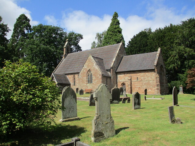
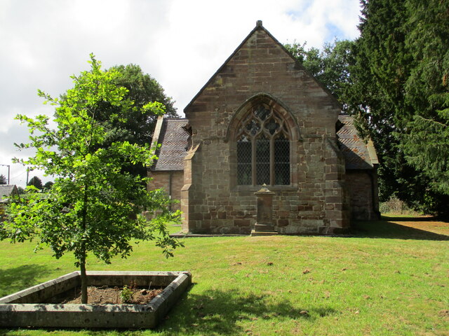
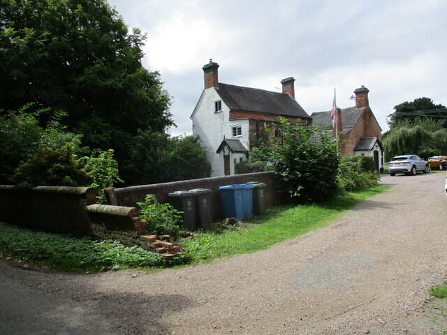
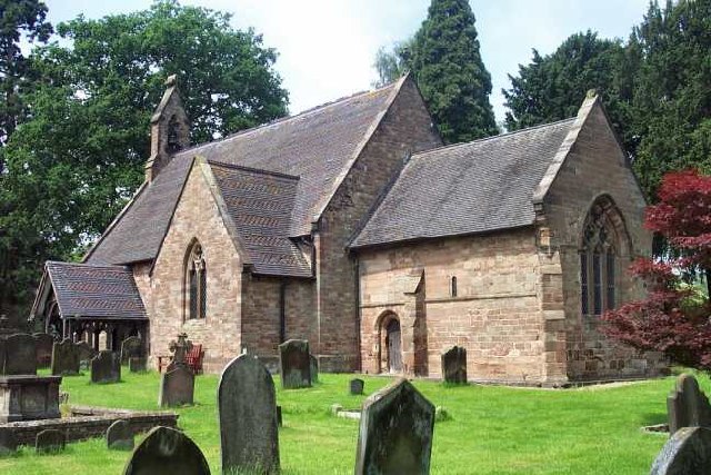
With a population of just over 500 residents, Lapley maintains a close-knit community atmosphere. The village is characterized by its charming, traditional architecture, featuring a mix of historic cottages and modern homes. The local church, St. Peter's Church, is an impressive medieval structure dating back to the 13th century and is a prominent landmark in the area.

Lapley benefits from its convenient location, providing easy access to nearby towns and cities. The village is well-connected by road, with the A5 and M6 motorway just a short drive away, offering connections to Birmingham, Stoke-on-Trent, and Wolverhampton.

Despite its small size, Lapley offers a range of amenities for residents and visitors. The village boasts a well-regarded primary school, ensuring local children have access to quality education. Additionally, there is a village hall that hosts various community events and gatherings, providing a hub for social activities.

Surrounding Lapley, the Staffordshire countryside offers numerous opportunities for outdoor pursuits, including walking, cycling, and horse riding. The nearby Cannock Chase Area of Outstanding Natural Beauty is a popular destination for nature lovers, offering vast woodlands, heathlands, and abundant wildlife.

Overall, Lapley is a charming village with a strong sense of community, offering a tranquil rural lifestyle within easy reach of larger towns and cities.

If you have any feedback on the listing, please let us know in the comments section below.

Lapley Images

Images are sourced within 2km of 52.709727/-2.189369 or Grid Reference SJ8712. Thanks to Geograph Open Source API. All images are credited.
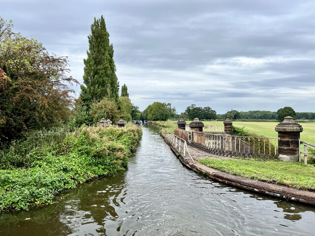
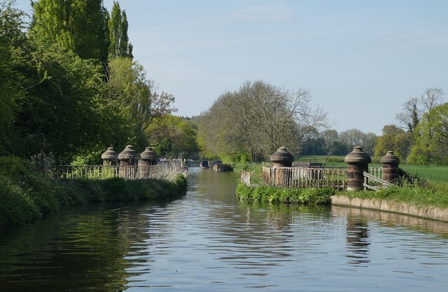
Shropshire Union Canal - Stretton Aqueduct The Stretton Aqueduct carries the Shropshire Union Canal over the A5 Watling Street. It was constructed by Thomas Telford in 1832 at which time this stretch of the canal was known as the Birmingham and Liverpool Junction Canal. It is 30' (9.1 m) over the A5 road, though originally not quite as tall as in 1961–62, the road under it was lowered by c.4' (1.2 m) to allow taller vehicles to pass beneath.
It is EH Grade II listed <span class="nowrap"><a title="https://historicengland.org.uk/listing/the-list/list-entry/1039259" rel="nofollow ugc noopener" href="https://historicengland.org.uk/listing/the-list/list-entry/1039259">Link</a><img style="margin-left:2px;" alt="External link" title="External link - shift click to open in new window" src="https://s1.geograph.org.uk/img/external.png" width="10" height="10"/></span>
See also <a href="https://www.geograph.org.uk/photo/7163556">SJ8710 : Shropshire Union Canal - A5 from Stretton Aqueduct</a> and for the view from the A5, see for example <a href="https://www.geograph.org.uk/photo/1785449">SJ8710 : Stretton Aqueduct for the Liverpool and Birmingham Canal</a>
Shropshire Union Canal - Stretton Aqueduct
The Stretton Aqueduct carries the Shropshire Union Canal over the A5 Watling Street. It was constructed by Thomas Telford in 1832 at which time this stretch of the canal was known as the Birmingham and Liverpool Junction Canal. It is 30' (9.1 m) over the A5 road, though originally not quite as tall as in 1961–62, the road under it was lowered by c.4' (1.2 m) to allow taller vehicles to pass beneath. It is EH Grade II listed LinkExternal link See also SJ8710 : Shropshire Union Canal - A5 from Stretton Aqueduct and for the view from the A5, see for example SJ8710 : Stretton Aqueduct for the Liverpool and Birmingham Canal
Shropshire Union Canal - A5 from Stretton Aqueduct Looking due east along the A5 (Roman Watling Street) from Telford's 1832 aqueduct.
See also <a href="https://www.geograph.org.uk/photo/7163551">SJ8710 : Shropshire Union Canal - Stretton Aqueduct</a>
For the opposite view (from the A5, looking up at the aqueduct) see for example <a href="https://www.geograph.org.uk/photo/1785449">SJ8710 : Stretton Aqueduct for the Liverpool and Birmingham Canal</a>
Shropshire Union Canal - A5 from Stretton Aqueduct
Looking due east along the A5 (Roman Watling Street) from Telford's 1832 aqueduct. See also SJ8710 : Shropshire Union Canal - Stretton Aqueduct For the opposite view (from the A5, looking up at the aqueduct) see for example SJ8710 : Stretton Aqueduct for the Liverpool and Birmingham Canal
Shropshire Union Canal - Wheaton Aston Lock - Upper gate Looking back at the upper gate of Wheaton Aston Lock on the Shropshire Union Canal. There are only six* locks between the southern terminus of the 'Shroppie' at Autherley Junction and beyond Market Drayton, this is the first of them when travelling northwards. The upper gates on this canal are a single flat wooden barrier while the downstream ones are two gates forming a V pointing into the lock - this is very common though on broad beam canals such as the Grand Union both sets are of the V type.
* There is also a Stop Lock at Autherley Junction itself.
Shropshire Union Canal - Wheaton Aston Lock - Upper gate
Looking back at the upper gate of Wheaton Aston Lock on the Shropshire Union Canal. There are only six* locks between the southern terminus of the 'Shroppie' at Autherley Junction and beyond Market Drayton, this is the first of them when travelling northwards. The upper gates on this canal are a single flat wooden barrier while the downstream ones are two gates forming a V pointing into the lock - this is very common though on broad beam canals such as the Grand Union both sets are of the V type. * There is also a Stop Lock at Autherley Junction itself.
Shropshire Union Canal - Wheaton Aston Bridge (No.18) This bridge (No.18, Wheaton Aston Bridge) is just SE of the lock at Wheaton Aston (see <a href="https://www.geograph.org.uk/photo/7163574">SJ8512 : Shropshire Union Canal - Wheaton Aston Lock - Upper gate</a>)
The bridge is EH Grade II listed: <span class="nowrap"><a title="https://historicengland.org.uk/listing/the-list/list-entry/1039256?section=official-list-entry" rel="nofollow ugc noopener" href="https://historicengland.org.uk/listing/the-list/list-entry/1039256?section=official-list-entry">Link</a><img style="margin-left:2px;" alt="External link" title="External link - shift click to open in new window" src="https://s1.geograph.org.uk/img/external.png" width="10" height="10"/></span>
Shropshire Union Canal - Wheaton Aston Bridge (No.18)
This bridge (No.18, Wheaton Aston Bridge) is just SE of the lock at Wheaton Aston (see SJ8512 : Shropshire Union Canal - Wheaton Aston Lock - Upper gate) The bridge is EH Grade II listed: LinkExternal link
Lychgate, Stretton
Lychgate, Stretton
Stoney Lane, Stretton
St John's church, Stretton A twelfth century chancel attached to a nineteenth century nave and transepts <span class="nowrap"><a title="https://historicengland.org.uk/listing/the-list/list-entry/1374085?section=official-list-entry" rel="nofollow ugc noopener" href="https://historicengland.org.uk/listing/the-list/list-entry/1374085?section=official-list-entry">Link</a><img style="margin-left:2px;" alt="External link" title="External link - shift click to open in new window" src="https://s1.geograph.org.uk/img/external.png" width="10" height="10"/></span>
St John's church, Stretton
A twelfth century chancel attached to a nineteenth century nave and transepts LinkExternal link
St John's church, Stretton, east end The chancel dates from the twelfth century but the east window is an alteration of the fourteenth century <span class="nowrap"><a title="https://historicengland.org.uk/listing/the-list/list-entry/1374085?section=official-list-entry" rel="nofollow ugc noopener" href="https://historicengland.org.uk/listing/the-list/list-entry/1374085?section=official-list-entry">Link</a><img style="margin-left:2px;" alt="External link" title="External link - shift click to open in new window" src="https://s1.geograph.org.uk/img/external.png" width="10" height="10"/></span>
St John's church, Stretton, east end
The chancel dates from the twelfth century but the east window is an alteration of the fourteenth century LinkExternal link
Houses and bins, Stretton
Aqueduct from the canal Grade II listed. Listing number 1039259. Aqueduct dated 1832. Thomas Telford Engineer. Cast iron box girder span, blue brick abutments with stone dressings. Single segmental arch below girders, taken to concave abutments with roll moulded stone string at springing level and bounded by engaged stone columns, taken up above corbelled stone towpath coping and ornamental cast iron parapet railings to slightly domed cappings. Cast inscription in centre panel of beam reads 'Birmingham and Liverpool Canal Thos'.
Aqueduct from the canal
Grade II listed. Listing number 1039259. Aqueduct dated 1832. Thomas Telford Engineer. Cast iron box girder span, blue brick abutments with stone dressings. Single segmental arch below girders, taken to concave abutments with roll moulded stone string at springing level and bounded by engaged stone columns, taken up above corbelled stone towpath coping and ornamental cast iron parapet railings to slightly domed cappings. Cast inscription in centre panel of beam reads 'Birmingham and Liverpool Canal Thos'.
Boats moored at Stretton Wharf On the Shropshire Union Canal.
Boats moored at Stretton Wharf
On the Shropshire Union Canal.
Towards Lapley Wood bridge On the Shropshire Union Canal.
Towards Lapley Wood bridge
On the Shropshire Union Canal.
Wheaton Aston bridge Grade II listed. Listing number 1039256. Accommodation bridge over canal, circa 1832. Limewashed brickwork with stone coping and string course. Single elliptical arch on slightly concave sided plan with cambered carriageway and parapet, half round coping with piers at ends and cast iron hawser spurs at springings on towpath side. The Shropshire Union Canal was engineered by Thomas Telford, and completed in 1835.
Wheaton Aston bridge
Grade II listed. Listing number 1039256. Accommodation bridge over canal, circa 1832. Limewashed brickwork with stone coping and string course. Single elliptical arch on slightly concave sided plan with cambered carriageway and parapet, half round coping with piers at ends and cast iron hawser spurs at springings on towpath side. The Shropshire Union Canal was engineered by Thomas Telford, and completed in 1835.
View from Wheaton Aston lock On the Shropshire Union Canal.
View from Wheaton Aston lock
On the Shropshire Union Canal.
Boats moored at Wheaton Aston On the Shropshire Union Canal.
Boats moored at Wheaton Aston
On the Shropshire Union Canal.
Tavern Bridge Grade II listed. Listing number 1374084. Accommodation bridge over canal, circa 1832. Limewashed brickwork with stone coping and string course. Single vaulted elliptical arch with level carriageway and parapet, half round coping with piers at ends; cast iron hawser spurs at springings on towpath side.
Tavern Bridge
Grade II listed. Listing number 1374084. Accommodation bridge over canal, circa 1832. Limewashed brickwork with stone coping and string course. Single vaulted elliptical arch with level carriageway and parapet, half round coping with piers at ends; cast iron hawser spurs at springings on towpath side.
Bridleway east of Bishopswood in Staffordshire Here the bridleway from Ivetsey Bank Road leads north-east towards Top Barn Farm (formerly Black Ladies Cottages). At least one map, and local addresses, name the bridleway behind the camera as Sandy Lane. The weather was dull and cold all morning, but brightened up (briefly) soon after this.
Bridleway east of Bishopswood in Staffordshire
Here the bridleway from Ivetsey Bank Road leads north-east towards Top Barn Farm (formerly Black Ladies Cottages). At least one map, and local addresses, name the bridleway behind the camera as Sandy Lane. The weather was dull and cold all morning, but brightened up (briefly) soon after this.
Stretton Aqueduct, Shropshire Union Canal The text on the iron trough aqueduct proclaims this to be the Birmingham and Liverpool [Junction] Canal, which ran from Nantwich to Autherley Junction outside Wolverhampton and later became part of the Shropshire Union system.  The name of the engineer Thomas Telford is below.  Telford also engineered the turnpike road that passes beneath it, the A5 London to Holyhead road.
Stretton Aqueduct, Shropshire Union Canal
The text on the iron trough aqueduct proclaims this to be the Birmingham and Liverpool [Junction] Canal, which ran from Nantwich to Autherley Junction outside Wolverhampton and later became part of the Shropshire Union system. The name of the engineer Thomas Telford is below. Telford also engineered the turnpike road that passes beneath it, the A5 London to Holyhead road.
Show me another place!

Lapley is located at Grid Ref: SJ8712 (Lat: 52.709727, Lng: -2.189369)

Administrative County: Staffordshire

District: South Staffordshire

Police Authority: Staffordshire

What 3 Words

///greyhound.reshape.dodges. Near Wheaton Aston, Staffordshire

Nearby Locations

Lapley

Related Wikis

Lapley

Lapley is a village and former civil parish, now in the parish of Lapley, Stretton and Wheaton Aston, in the South Staffordshire district, in the county...

Lapley Priory

Lapley Priory was a priory in Staffordshire, England. Founded at the very end of the Anglo-Saxon period, it was an alien priory, a satellite house of the...

Lapley, Stretton and Wheaton Aston

Lapley, Stretton and Wheaton Aston is a civil parish in the South Staffordshire district, in the county of Staffordshire, England. The population of the...

St John's Church, Stretton

St John's Church, Stretton is the Church of England parish church of Stretton, South Staffordshire. == History == The chancel is 12th century. The nave...

Stretton Hall, Staffordshire

Stretton Hall is an early 18th-century mansion house at Stretton, South Staffordshire. It is the home of a branch of the Monckton family descended from...

Stretton, South Staffordshire

Stretton is a village and former civil parish, now in the parish of Lapley, Stretton and Wheaton Aston, in the South Staffordshire district, in the county...

Stretton Aqueduct

Stretton Aqueduct is a short cast iron canal aqueduct between Stretton and Brewood, and near to Belvide Reservoir, in south Staffordshire, England. Designed...

Bickford

Bickford is a village in Staffordshire, England. For population details taken at the 2011 census see Penkridge == See also == Listed buildings in Penkridge...

Nearby Amenities

Located within 500m of 52.709727,-2.189369
Lapley
Place: village
Wikidata: Q5042808
Lat/Long: 52.7136341/-2.1875317
Vaughan Arms
Naptan AtcoCode: 3800C607100
Naptan Bearing: NE
Naptan BusStopType: CUS
Naptan CommonName: Vaughan Arms
Naptan Indicator: Adj
Naptan Landmark: Vaughan Arms
Naptan Street: Bickford Rd
Naptan Verified: no
Public Transport: platform
Source: naptan_import
Lat/Long: 52.7140503/-2.1880154
Bus Stop
Vaughan Arms
Naptan AtcoCode: 3800C607101
Naptan Bearing: SW
Naptan CommonName: Vaughan Arms
Naptan Indicator: Opp
Naptan Landmark: Vaughan Arms
Naptan Street: Bickford Rd
Naptan Verified: no
Public Transport: platform
Source: naptan_import
Lat/Long: 52.7139333/-2.1880741
Post Box
Post Box Mounting: wooden_post
Post Box Type: lamp
Lat/Long: 52.7138339/-2.1880857
Barrier: stile
Steps: 1
Stile: stepover
Lat/Long: 52.7140469/-2.1895522
Bench
Lat/Long: 52.7138884/-2.1881805
Information: board
Tourism: information
Lat/Long: 52.7138175/-2.1880546
Defibrillator
Access: yes
Booth: K6
Covered: booth
Defibrillator Location: in phone box, Lapley
Disused Amenity: telephone
Emergency: defibrillator
Man Made: telephone_box
Lat/Long: 52.7138558/-2.1880841
War Memorial
Historic: memorial
Source: survey
Lat/Long: 52.7136012/-2.1902294
Generator Method: photovoltaic
Generator Output Electricity: yes
Generator Source: solar
Generator Type: solar_photovoltaic_panel
Location: roof
Power: generator
Source: bing
Lat/Long: 52.7123947/-2.1876781
Generator Method: photovoltaic
Generator Output Electricity: yes
Generator Source: solar
Generator Type: solar_photovoltaic_panel
Location: roof
Power: generator
Source: bing
Lat/Long: 52.7123427/-2.1876217
Generator Method: photovoltaic
Generator Output Electricity: yes
Generator Source: solar
Generator Type: solar_photovoltaic_panel
Location: roof
Power: generator
Lat/Long: 52.7139961/-2.1870652
Information: guidepost
Tourism: information
Lat/Long: 52.7139047/-2.1880829
The data included in this document is from www.openstreetmap.org. The data is made available under ODbL.

Have you been to Lapley?

Leave your review of Lapley below (or comments, questions and feedback).