Easton Hope

Valley in Peeblesshire

Scotland

Easton Hope

View along boundary fence from Long Grain Knowe towards Grey Weather Law These small peat hags were the only sheltered spot to have lunch on this windy day.
View along boundary fence from Long Grain Knowe towards Grey Weather Law Credit: Colin Park

Easton Hope is a picturesque valley located in Peeblesshire, a historic county in the Scottish Borders region of Scotland. Situated approximately 25 miles south of Edinburgh, this charming valley offers a tranquil retreat from the bustling city life.

Surrounded by rolling hills and lush greenery, Easton Hope boasts stunning natural beauty and a serene atmosphere. The valley is traversed by the Hope Water, a small river that adds to the idyllic charm of the area. The valley is also home to diverse flora and fauna, making it an excellent spot for nature enthusiasts and wildlife lovers.

Historically, Easton Hope played a significant role as an agricultural area, with farms and fields dotting the landscape. While the agricultural tradition is still present, the valley has also embraced tourism, attracting visitors with its scenic walking trails and breathtaking vistas. The trails offer hikers and ramblers the opportunity to explore the area's natural wonders, including ancient woodlands and cascading waterfalls.

In terms of amenities, Easton Hope offers limited services, as it primarily caters to those seeking a peaceful getaway. However, nearby Peebles town provides essential facilities such as shops, restaurants, and accommodations.

Overall, Easton Hope is a hidden gem in Peeblesshire, offering a haven of tranquility and natural beauty. Whether one seeks a leisurely stroll through nature, a chance to spot wildlife, or simply a break from the hectic pace of city life, this valley provides a perfect retreat.

If you have any feedback on the listing, please let us know in the comments section below.
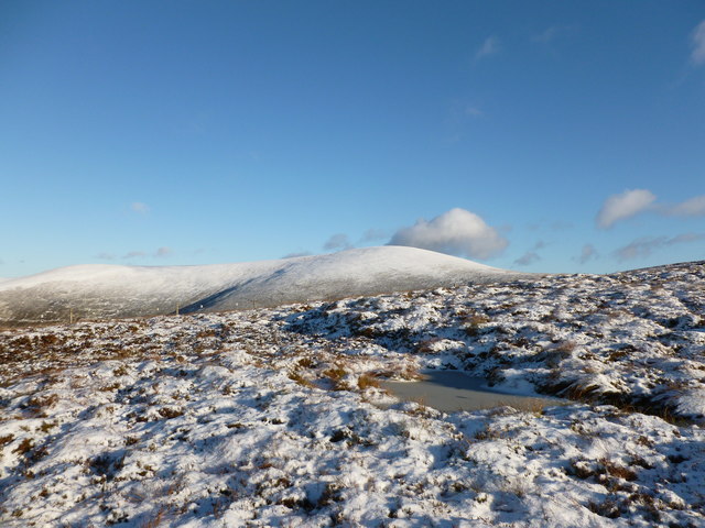
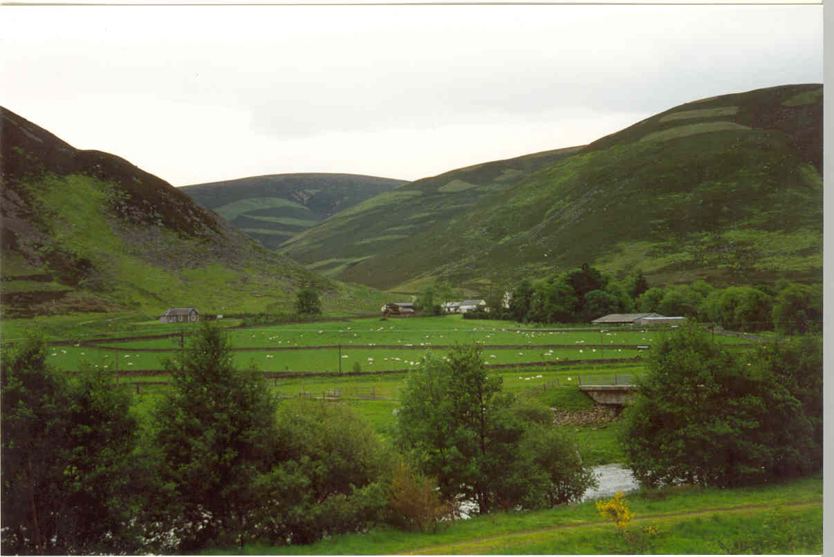
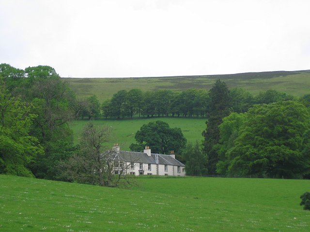
Easton Hope Images

Images are sourced within 2km of 55.557666/-3.343039 or Grid Reference NT1530. Thanks to Geograph Open Source API. All images are credited.

View along boundary fence from Long Grain Knowe towards Grey Weather Law These small peat hags were the only sheltered spot to have lunch on this windy day.
View along boundary fence from Long Grain Knowe towards Grey Weather Law
These small peat hags were the only sheltered spot to have lunch on this windy day.
Heading towards Middle Hill from Long Grain Knowe There is a faint ATV track to follow in places along this stretch.
Heading towards Middle Hill from Long Grain Knowe
There is a faint ATV track to follow in places along this stretch.
Summit of Middle Hill near Drumelzier A few old fence posts mark the summit of this rather featureless hill.
Summit of Middle Hill near Drumelzier
A few old fence posts mark the summit of this rather featureless hill.
Approaching Shepherds Cairn on Glenstivon Dod A faint path runs along the broad ridge.
Approaching Shepherds Cairn on Glenstivon Dod
A faint path runs along the broad ridge.
Descending from Glenstivon Dod towards Drumelzier Law A decent path runs along this ridge giving some fine walking.
Descending from Glenstivon Dod towards Drumelzier Law
A decent path runs along this ridge giving some fine walking.
Den Knowes Head High up on the northern slopes of Pykestone Hill with fine views of from left Drumelzier Law, Culter Fell, Chapelgill Hill and Tinto. A grand day out in the Borders with a nice breeze to cool off.
Den Knowes Head
High up on the northern slopes of Pykestone Hill with fine views of from left Drumelzier Law, Culter Fell, Chapelgill Hill and Tinto. A grand day out in the Borders with a nice breeze to cool off.
Drumelzier Law On lovely ground between Glenstivon Dod looking towards Drumelzier Law - fine Borders scenery and walking country. Very different colours to this image here from abut 6 weeks later in the year in 2021.
<a title="https://www.geograph.org.uk/photo/7032846" href="https://www.geograph.org.uk/photo/7032846">Link</a>
Drumelzier Law
On lovely ground between Glenstivon Dod looking towards Drumelzier Law - fine Borders scenery and walking country. Very different colours to this image here from abut 6 weeks later in the year in 2021. Link
North-west spur of Taberon Law Frozen ground and a light smattering of snow makes the going a bit less boggy here.  Culter Fell and the Glenkerie Wind Farm can be seen in the distance.
North-west spur of Taberon Law
Frozen ground and a light smattering of snow makes the going a bit less boggy here. Culter Fell and the Glenkerie Wind Farm can be seen in the distance.
Frozen pool on Taberon Law Looking towards a snow-covered Drumelzier Law and Glenstivon Dod.
Frozen pool on Taberon Law
Looking towards a snow-covered Drumelzier Law and Glenstivon Dod.
Col between Taberon Law and Middle Hill There is a slight descent here to a shallow col.  

An outbreak of northerly air has temporarily brought a cold and crisp interlude and some snow in the otherwise rather soggy month of November 2015.
Col between Taberon Law and Middle Hill
There is a slight descent here to a shallow col. An outbreak of northerly air has temporarily brought a cold and crisp interlude and some snow in the otherwise rather soggy month of November 2015.
Col below Middle Hill A gentle descent from Taberon Law leads to this shallow col.

An outbreak of northerly air has brought a temporary crisp and cold interval with some snow during the otherwise largely soggy month of November 2015.
Col below Middle Hill
A gentle descent from Taberon Law leads to this shallow col. An outbreak of northerly air has brought a temporary crisp and cold interval with some snow during the otherwise largely soggy month of November 2015.
Track towards Middle Hill Frozen ground and light snow cover makes this area less boggy than it might otherwise be.
Track towards Middle Hill
Frozen ground and light snow cover makes this area less boggy than it might otherwise be.
Middle Hill As the name suggests, Middle Hill lies in the middle of a triangle of high moorland summits, the other 'corners' of the triangle being Glenstivon Dod and Long Grain Knowe.

In an otherwise soggy November, an influx of northerly air has temporarily brought crisp, cold walking conditions.
Middle Hill
As the name suggests, Middle Hill lies in the middle of a triangle of high moorland summits, the other 'corners' of the triangle being Glenstivon Dod and Long Grain Knowe. In an otherwise soggy November, an influx of northerly air has temporarily brought crisp, cold walking conditions.
Looking towards Dollar Law On the flat plateau of Middle Hill in crisp, snowy conditions.
Looking towards Dollar Law
On the flat plateau of Middle Hill in crisp, snowy conditions.
Fenceline on Middle Law It's possible to walk long distances on these gentle, plateau-topped hills without having to lose or gain much height.
Fenceline on Middle Law
It's possible to walk long distances on these gentle, plateau-topped hills without having to lose or gain much height.
The Dollar Law group The rounded hills of Dollar Law, Fifescar Knowe and Dun Law viewed across the hillside near the head of Stan Hope.
The Dollar Law group
The rounded hills of Dollar Law, Fifescar Knowe and Dun Law viewed across the hillside near the head of Stan Hope.
Middle Hill Bump in the Tweedsmuir Hills.
Middle Hill
Bump in the Tweedsmuir Hills.
Thief's road, Tweedsmuir Hills View towards Dollar Law from Grey Wether Law with the old drove road contouring a slope.
Thief's road, Tweedsmuir Hills
View towards Dollar Law from Grey Wether Law with the old drove road contouring a slope.
Show me another place!

Easton Hope is located at Grid Ref: NT1530 (Lat: 55.557666, Lng: -3.343039)

Unitary Authority: The Scottish Borders

Police Authority: The Lothians and Scottish Borders

What 3 Words

///enclosing.leaky.secondly. Near Biggar, South Lanarkshire

Nearby Locations

Easton Hope

Related Wikis

Stanhope, Peeblesshire

Stanhope is a small settlement in the Scottish Borders region. It is situated in the parish of Drumelzier in Peeblesshire, in the valley of the River...

Mossfennan

Mossfennan is a small settlement in southern Scotland near Drumelzier in the Scottish Borders, in the valley of the River Tweed. Mossfennan is a wooded...

Drumelzier

Drumelzier (), is a village and civil parish on the B712 in the Tweed Valley in the Scottish Borders. The area of the village is extensive and includes...

Polmood

Polmood is a small settlement in southern Scotland near Tweedsmuir in the Scottish Borders, in the valley of the River Tweed. Polmood was for many centuries...

Wrae Tower

Wrae Tower is a ruined 16th-century stone tower house, located in the upper Tweed Valley in the Scottish Borders area of Scotland, and similarly south...

A701 road

The A701 is a major road in Scotland that runs from Dumfries to Edinburgh. == Route == The A701 leaves Dumfries and travels north to meet the A74(M) east...

Dawyck Chapel

Dawyck Chapel, also known as Dalwick Church, is located (NGR NT 16798 34933) within the Parish of Drumelzier in the Scottish Borders area of Scotland....

Bellspool

Bellspool is a village in the Scottish Borders area of Scotland, near to Drumelzier, Hopcarton and Kingledoors == See also == List of places in the Scottish...

Have you been to Easton Hope?

Leave your review of Easton Hope below (or comments, questions and feedback).