Moffat Dale

Valley in Dumfriesshire

Scotland

Moffat Dale

Blackhope Burn Looking towards the whitewashed cottages at Blackshope, in Moffat Dale.
Blackhope Burn Credit: Alan O'Dowd

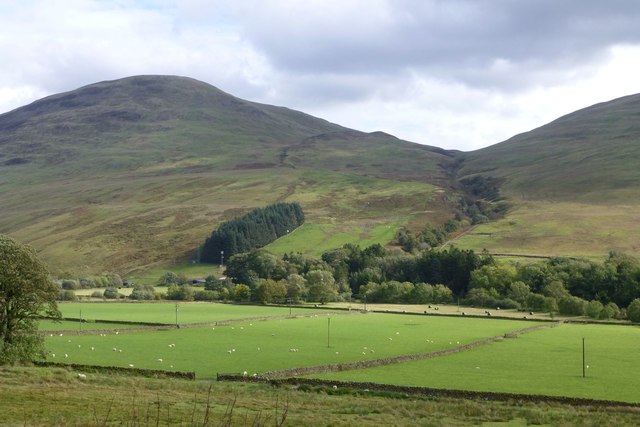
Moffat Dale is a picturesque valley located in Dumfriesshire, Scotland. Situated in the southern part of the country, the valley is surrounded by rolling hills and offers breathtaking views of the natural landscape. It is named after the nearby town of Moffat, which is known for its historic charm and is a popular tourist destination.

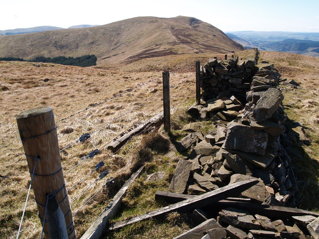
The valley is renowned for its stunning scenery, with lush green pastures, meandering rivers, and dense forests. It is a haven for outdoor enthusiasts, offering a wide range of activities such as hiking, cycling, and birdwatching. The nearby Southern Upland Way, a long-distance footpath, passes through Moffat Dale, attracting walkers from far and wide.

Wildlife thrives in this diverse ecosystem, with various species of birds, mammals, and plants calling Moffat Dale their home. Visitors can spot red squirrels, roe deer, and numerous bird species, including the iconic golden eagle.

Historically, Moffat Dale has been an important route for trade and transportation. The valley was once a hub for the wool and textile industry, with several mills operating along the riverside. Today, remnants of this industrial past can still be seen, adding to the area's rich cultural heritage.

Moffat Dale offers a tranquil retreat for those seeking peace and serenity amidst nature's beauty. With its scenic landscapes, abundant wildlife, and historical significance, it is a must-visit destination for nature lovers and history enthusiasts alike.

If you have any feedback on the listing, please let us know in the comments section below.

Moffat Dale Images

Images are sourced within 2km of 55.362335/-3.3579813 or Grid Reference NT1408. Thanks to Geograph Open Source API. All images are credited.

Blackhope Burn Looking towards the whitewashed cottages at Blackshope, in Moffat Dale.
Blackhope Burn
Looking towards the whitewashed cottages at Blackshope, in Moffat Dale.
Cottages and sheds at Blackshope The Saddle Yoke ridge is prominent in the background.
Cottages and sheds at Blackshope
The Saddle Yoke ridge is prominent in the background.
Saddle Yoke rises above Bodesbeck The Saddle Yoke ridge, partly in shade here, forms a dramatic backdrop to the farm and houses at Bodesbeck.
Saddle Yoke rises above Bodesbeck
The Saddle Yoke ridge, partly in shade here, forms a dramatic backdrop to the farm and houses at Bodesbeck.
Area round Brownies Cave, Bodesbeck This location seemingly features in 'The Brownie of Bodsbeck', an 1818 novel by James Hogg, who is sometimes known as The Ettrick Shepherd.  It is set in 1685, in the time of the Covenanters and their persecution by the Royalists.

<span class="nowrap"><a title="https://en.wikipedia.org/wiki/The_Brownie_of_Bodsbeck" rel="nofollow ugc noopener" href="https://en.wikipedia.org/wiki/The_Brownie_of_Bodsbeck">Link</a><img style="margin-left:2px;" alt="External link" title="External link - shift click to open in new window" src="https://s1.geograph.org.uk/img/external.png" width="10" height="10"/></span>
Area round Brownies Cave, Bodesbeck
This location seemingly features in 'The Brownie of Bodsbeck', an 1818 novel by James Hogg, who is sometimes known as The Ettrick Shepherd. It is set in 1685, in the time of the Covenanters and their persecution by the Royalists. LinkExternal link
Hang Gill A small ravine through which flows the Hang Burn on its way to join the Blackhope Burn, itself in turn a tributary of the Moffat Water.
Hang Gill
A small ravine through which flows the Hang Burn on its way to join the Blackhope Burn, itself in turn a tributary of the Moffat Water.
Looking towards Bodesbeck Farm from A708 It’s possible to walk or cycle a hill track from this farm and up and over to the Ettrick Valley on the other side.
Looking towards Bodesbeck Farm from A708
It’s possible to walk or cycle a hill track from this farm and up and over to the Ettrick Valley on the other side.
Forestry road in Craigieburn Wood
Keepers Lodge
Keepers Lodge
Across the valley to Selcoth
A708 in Moffatdale
A708 in Moffatdale
The A708 near Blackshope
Road Bridge at Capplegill, north-east of Moffat The bridge carries the A708, the Moffat to Selkirk road, across the Blackhope Burn.
Road Bridge at Capplegill, north-east of Moffat
The bridge carries the A708, the Moffat to Selkirk road, across the Blackhope Burn.
Looking  up the track to Selcoth Selcoth Burn flows from the valley to the farm.
Broken Back is the prominent hill on the left.
Looking up the track to Selcoth
Selcoth Burn flows from the valley to the farm. Broken Back is the prominent hill on the left.
Sheep in pasture  Between Capplegill and Bodesbeck.
Bodesbeck Law on the left.
In Moffat Dale.
Sheep in pasture
Between Capplegill and Bodesbeck. Bodesbeck Law on the left. In Moffat Dale.
New tracks near the Selcoth Burn New tracks going round the new tree plantations on either side of the burn.
New tracks near the Selcoth Burn
New tracks going round the new tree plantations on either side of the burn.
Forest track on Sailfoot Law Looking towards Moffat Dale with Queensberry on the horizon.
Forest track on Sailfoot Law
Looking towards Moffat Dale with Queensberry on the horizon.
Forest track on Sailfoot Law Through part of a felled area of the forest.
Forest track on Sailfoot Law
Through part of a felled area of the forest.
A field of buttercups and clover And sheep but not the usual Cheviots or Blackface.
A field of buttercups and clover
And sheep but not the usual Cheviots or Blackface.
Show me another place!

Moffat Dale is located at Grid Ref: NT1408 (Lat: 55.362335, Lng: -3.3579813)

Unitary Authority: Dumfries and Galloway

Police Authority: Dumfries and Galloway

What 3 Words

///makeup.sprouts.weaved. Near Moffat, Dumfries & Galloway

Nearby Locations

Moffat Dale Roundstonefoot

Related Wikis

Croft Head

Croft Head is a hill in the Ettrick Hills range, part of the Southern Uplands of Scotland. It offers unobstructed views to the Solway Firth, the fells...

Bodesbeck Law

Bodesbeck Law is a hill in the Ettrick Hills range, part of the Southern Uplands of Scotland. It is the primary west-south-western terminus of the ridge...
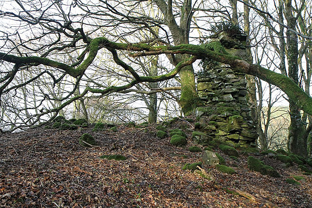
Cornal Tower

Cornal Tower is the ruins of a tower house located near Moffat, Dumfries-shire, Scotland. Alternative names are Polcornare, Cornal Burn, or Logan. The...

Hart Fell

Hart Fell is a hill in the Moffat Hills range, part of the Southern Uplands of Scotland. It lies north of the town of Moffat on the border with the Scottish...

Nearby Amenities

Located within 500m of 55.362335,-3.3579813
Roundstonefoot
Place: hamlet
Source: NLS - OS 6-inch Scotland 1842-82
Lat/Long: 55.363055/-3.3578202
The Old Schoolhouse
Guest House: bed_and_breakfast
Tourism: guest_house
Lat/Long: 55.3636728/-3.3577699
Power: pole
Lat/Long: 55.358865/-3.3608264
Power: pole
Lat/Long: 55.3594726/-3.3602391
Power: pole
Lat/Long: 55.3601945/-3.3595436
Power: pole
Lat/Long: 55.3609076/-3.3588481
Power: pole
Lat/Long: 55.3622385/-3.3575627
Power: pole
Lat/Long: 55.3628944/-3.3569239
Power: pole
Lat/Long: 55.3635313/-3.3562824
Power: pole
Lat/Long: 55.364278/-3.3559682
Power: pole
Lat/Long: 55.3650188/-3.3556153
Power: pole
Lat/Long: 55.3657727/-3.3553113
The data included in this document is from www.openstreetmap.org. The data is made available under ODbL.

Have you been to Moffat Dale?

Leave your review of Moffat Dale below (or comments, questions and feedback).