Red Scar
Valley in Dumfriesshire
Scotland
Red Scar

Red Scar is a picturesque valley located in Dumfriesshire, Scotland. Nestled amidst the rolling hills and lush green meadows, this enchanting valley is known for its stunning natural beauty and rich historical significance.
The valley derives its name from the distinctive red sandstone cliffs that tower above the surrounding landscape. These cliffs, carved over centuries by the meandering River Nith, create a dramatic backdrop and add to the valley's charm.
Red Scar is a haven for nature enthusiasts, offering a diverse range of flora and fauna. The valley is home to various species of birds, including buzzards and red kites, making it a popular spot for birdwatching. The river flowing through the valley supports a thriving ecosystem of aquatic life, providing ample opportunities for fishing and sightseeing.
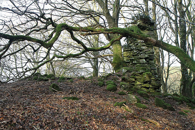
The historical significance of Red Scar can be traced back to ancient times. The area is dotted with remnants of Iron Age settlements, indicating human habitation in the region for thousands of years. Additionally, nearby ruins of medieval castles and towers serve as a reminder of the area's turbulent past.
Visitors to Red Scar can indulge in a range of outdoor activities. The valley offers numerous walking trails, allowing visitors to explore its natural wonders at their own pace. The nearby village of Dumfries provides easy access to amenities and accommodations for those wishing to stay longer and fully immerse themselves in the tranquility of Red Scar.
Overall, Red Scar in Dumfriesshire is a hidden gem, offering a captivating blend of natural beauty and historical significance, making it a must-visit destination for nature lovers and history enthusiasts alike.
If you have any feedback on the listing, please let us know in the comments section below.
Red Scar Images
Images are sourced within 2km of 55.291884/-3.3560463 or Grid Reference NT1300. Thanks to Geograph Open Source API. All images are credited.


Red Scar is located at Grid Ref: NT1300 (Lat: 55.291884, Lng: -3.3560463)
Unitary Authority: Dumfries and Galloway
Police Authority: Dumfries and Galloway
What 3 Words
///saturate.daredevil.connects. Near Beattock, Dumfries & Galloway
Nearby Locations
Related Wikis
Cornal Tower
Cornal Tower is the ruins of a tower house located near Moffat, Dumfries-shire, Scotland. Alternative names are Polcornare, Cornal Burn, or Logan. The...

Croft Head
Croft Head is a hill in the Ettrick Hills range, part of the Southern Uplands of Scotland. It offers unobstructed views to the Solway Firth, the fells...

Kirkpatrick-Juxta
Kirkpatrick-Juxta is a parish in Dumfries and Galloway on the A701, between Biggar, Moffat and Lockerbie. The parish straddles the main road A74 (M). It...

Wamphray railway station
Wamphray railway station served Newton Wamphray, near Beattock, in the Scottish county of Dumfries and Galloway. It was served by local trains on what...
Nearby Amenities
Located within 500m of 55.291884,-3.3560463Have you been to Red Scar?
Leave your review of Red Scar below (or comments, questions and feedback).