Archbank Hope

Valley in Dumfriesshire

Scotland

Archbank Hope

Between  Blue Cairn and Greygill Head A gentle broad ridge with a contrast between grass on one side of the fence and dyke and heather on the eastern side. The heather soon gives way to Sitka spruce.
Between Blue Cairn and Greygill Head Credit: Richard Webb

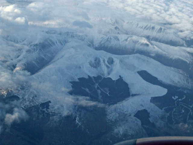
Archbank Hope is a small village located in the Dumfriesshire Valley, Scotland. Situated amidst picturesque landscapes, it is known for its tranquil and scenic surroundings. The village is nestled in a valley, surrounded by rolling hills and lush greenery, making it an ideal retreat for nature lovers.

Archbank Hope is home to a close-knit community, with a population of around 400 residents. The village is characterized by its charming traditional cottages and quaint streets, giving it a distinctive rural charm. The residents take pride in maintaining the village's heritage and preserving its unique character.

The village offers a range of amenities to cater to the needs of its residents. It has a local primary school, providing education to children in the area. Additionally, there is a community center that serves as a hub for various activities and gatherings. The center hosts events and social gatherings, fostering a sense of community spirit.

Nature enthusiasts can explore the surrounding area, which offers numerous walking trails and scenic spots. The nearby hills provide opportunities for outdoor activities such as hiking and cycling. The Dumfriesshire Valley is also known for its rich wildlife, with various species of birds and animals inhabiting the region.

Archbank Hope, with its serene ambiance and natural beauty, offers a peaceful and idyllic lifestyle. The village provides a close connection to nature and a strong sense of community, making it an attractive place to live for those seeking a peaceful retreat away from the hustle and bustle of city life.

If you have any feedback on the listing, please let us know in the comments section below.

Archbank Hope Images

Images are sourced within 2km of 55.363127/-3.4149148 or Grid Reference NT1008. Thanks to Geograph Open Source API. All images are credited.

Between  Blue Cairn and Greygill Head A gentle broad ridge with a contrast between grass on one side of the fence and dyke and heather on the eastern side. The heather soon gives way to Sitka spruce.
Between Blue Cairn and Greygill Head
A gentle broad ridge with a contrast between grass on one side of the fence and dyke and heather on the eastern side. The heather soon gives way to Sitka spruce.
Quarry below Blue Cairn Beyond the grassed over quarry, Swatte Fell emerges from the clag.
Quarry below Blue Cairn
Beyond the grassed over quarry, Swatte Fell emerges from the clag.
Forestry, Birnock Water A 1980s  and therefore still uniform forestry plantation upstream of Moffat.  It is getting less common seeing a big block without felled areas now, as big plantations fell out of favour in the mid 1980s. They are being planted again though, very much back in favour.
Forestry, Birnock Water
A 1980s and therefore still uniform forestry plantation upstream of Moffat. It is getting less common seeing a big block without felled areas now, as big plantations fell out of favour in the mid 1980s. They are being planted again though, very much back in favour.
The road in the Birnock Water forest A wet dark afternoon with a bit of a feel of Winter about it.
The road in the Birnock Water forest
A wet dark afternoon with a bit of a feel of Winter about it.
The Birnock Water View from the forest edge, upstream from here the glen is full of trees. Horrible weather.
The Birnock Water
View from the forest edge, upstream from here the glen is full of trees. Horrible weather.
Rough grazing upstream of Blaebeck Above the Birnock Water.
Rough grazing upstream of Blaebeck
Above the Birnock Water.
Auldton Fell from the Red Scars
Swatte Fell from the air A snow covered Swatte Fell, just north of Moffat, viewed from a Glasgow bound flight from Luton. The long finger of Roundstonefoot plantation can be seen on the right.
Swatte Fell from the air
A snow covered Swatte Fell, just north of Moffat, viewed from a Glasgow bound flight from Luton. The long finger of Roundstonefoot plantation can be seen on the right.
Swatte Fell from the air A snow covered Swatte Fell, just north of Moffat, viewed from a Glasgow bound flight from Luton. The long finger of Roundstonefoot plantation can be seen in the lower right corner.
Swatte Fell from the air
A snow covered Swatte Fell, just north of Moffat, viewed from a Glasgow bound flight from Luton. The long finger of Roundstonefoot plantation can be seen in the lower right corner.
Blue Cairn Gentle moorland on the east side of Swatte Fell. Quite a contrast to much of the hill which can be extremely steep.
Blue Cairn
Gentle moorland on the east side of Swatte Fell. Quite a contrast to much of the hill which can be extremely steep.
Quadbike track on Blue Cairn An easy way up or down Swatte Fell.
Quadbike track on Blue Cairn
An easy way up or down Swatte Fell.
Sheep below Blue Cairn Hill pasture on Swatte Fell.
Sheep below Blue Cairn
Hill pasture on Swatte Fell.
Forest roads, Birnock Water A steep descent to a bigger road in the forestry upstream of Blaebeck.  The foreground road is a good way out of the woods and on to Swatte Fell.
Forest roads, Birnock Water
A steep descent to a bigger road in the forestry upstream of Blaebeck. The foreground road is a good way out of the woods and on to Swatte Fell.
Annandale moorland Rough grazing on the slopes of Swatte Fell below Blue Cairn.  The sun at the head of the glen did not come out too often on Swatte Fell and it became a very wet day.
Annandale moorland
Rough grazing on the slopes of Swatte Fell below Blue Cairn. The sun at the head of the glen did not come out too often on Swatte Fell and it became a very wet day.
Moffat Well Discovered in 1633, the waters of this well were said to cure rheumatism, affections of the lungs and diseases of the skin.   In the last century visitors to the town would come to drink the waters.
Moffat Well
Discovered in 1633, the waters of this well were said to cure rheumatism, affections of the lungs and diseases of the skin. In the last century visitors to the town would come to drink the waters.
Gate and plantation, Mountainblow. The view from the shadow of one plantation to another across a meadow of rough grazing and bracken.
Gate and plantation, Mountainblow.
The view from the shadow of one plantation to another across a meadow of rough grazing and bracken.
Blaebeck, near Moffat A small farm just past the end of the public road at Moffat Well.
Blaebeck, near Moffat
A small farm just past the end of the public road at Moffat Well.
Ruined wall and forest, Greygill Head. Although quite steep-sided and rocky to the S, the summit of Greygill Head is flat and boggy, with an old wall breaking through the heather.
Ruined wall and forest, Greygill Head.
Although quite steep-sided and rocky to the S, the summit of Greygill Head is flat and boggy, with an old wall breaking through the heather.
Show me another place!

Archbank Hope is located at Grid Ref: NT1008 (Lat: 55.363127, Lng: -3.4149148)

Unitary Authority: Dumfries and Galloway

Police Authority: Dumfries and Galloway

What 3 Words

///wedding.downs.pursue. Near Moffat, Dumfries & Galloway

Nearby Locations

Archbank Hope Mere Cleuch

Related Wikis

Crown of Scotland (hill)

The Crown of Scotland is a hill in the Scottish Borders, Scotland. At a relatively small elevation from the surrounding peaks, it is situated to the north...
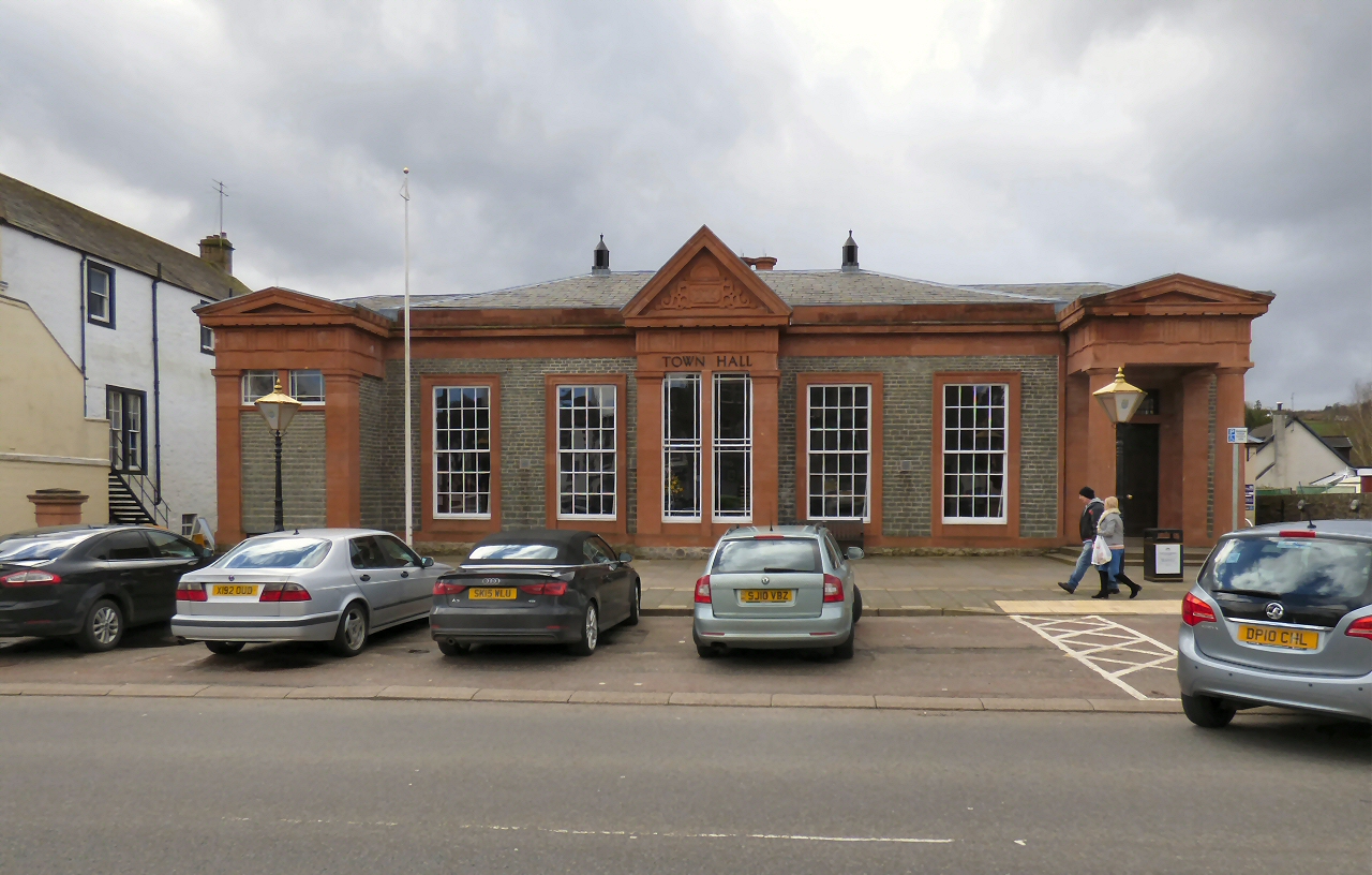
Moffat Town Hall

Moffat Town Hall is a municipal building in the High Street in Moffat, Dumfries and Galloway, Scotland. The structure, which is used as community events...

Moffat

Moffat (Scottish Gaelic: Mofad) is a burgh and parish in Dumfriesshire, now part of the Dumfries and Galloway local authority area in Scotland. It lies...

Moffat Museum

Moffat Museum is a community museum in Moffat, Scotland. It was established in the Old Moffat Bakehouse in 1984. The museum expanded into a neighbouring...

Nearby Amenities

Located within 500m of 55.363127,-3.4149148
The data included in this document is from www.openstreetmap.org. The data is made available under ODbL.

Have you been to Archbank Hope?

Leave your review of Archbank Hope below (or comments, questions and feedback).