Glenbuith

Valley in Dumfriesshire

Scotland

Glenbuith

Track and bridge crossing Garroch Water Looking northward. The bridge has recently been replaced (see earlier pictures) but has retained its 'Garroch' sign.
Track and bridge crossing Garroch Water Credit: Peter Wood

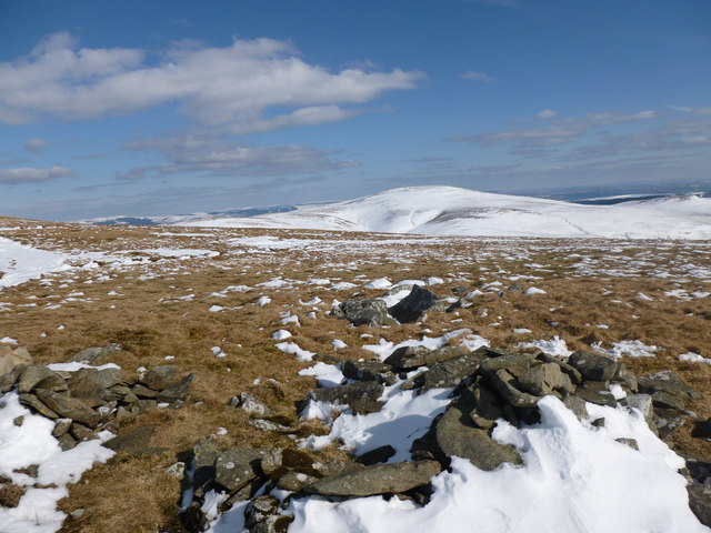
Glenbuith is a picturesque valley located in Dumfriesshire, Scotland. Situated in the southern part of the country, Glenbuith is renowned for its stunning natural beauty and tranquil atmosphere. Nestled between rolling hills and surrounded by lush greenery, the valley offers a peaceful escape from the hustle and bustle of city life.

The valley is characterized by its breathtaking landscapes, with a meandering river running through its center. The river is a popular spot for fishing enthusiasts, as it is home to a variety of fish species. Additionally, the valley is adorned with charming cottages and farmhouses, adding to its rustic charm.

Glenbuith is a haven for outdoor enthusiasts, offering a multitude of recreational activities. Hiking and walking trails crisscross the valley, providing opportunities for nature lovers to explore the surrounding hills and forests. The valley is also a great spot for birdwatching, with a diverse range of bird species found in the area.

For those interested in history and culture, Glenbuith has a rich heritage. The valley is dotted with ancient ruins and historical landmarks, including old castles and stone circles. These sites offer visitors a glimpse into the region's past and provide a sense of the area's historical significance.

Overall, Glenbuith is a hidden gem in Dumfriesshire, offering visitors a chance to immerse themselves in Scotland's natural beauty and tranquility. Whether it's exploring the scenic landscapes, engaging in outdoor activities, or delving into the valley's history, Glenbuith has something to offer for everyone seeking a peaceful retreat in the heart of Scotland.

If you have any feedback on the listing, please let us know in the comments section below.

Glenbuith Images

Images are sourced within 2km of 55.27763/-3.6687679 or Grid Reference NX9499. Thanks to Geograph Open Source API. All images are credited.

Track and bridge crossing Garroch Water Looking northward. The bridge has recently been replaced (see earlier pictures) but has retained its 'Garroch' sign.
Track and bridge crossing Garroch Water
Looking northward. The bridge has recently been replaced (see earlier pictures) but has retained its 'Garroch' sign.
Garroch Water The farm sign for Garroch has disintegrated and has been placed on the rail of the bridge.
Garroch Water
The farm sign for Garroch has disintegrated and has been placed on the rail of the bridge.
Ford on the Garroch Water The track into the hills crosses this burn, which drains into the slightly larger Capel Water.
Ford on the Garroch Water
The track into the hills crosses this burn, which drains into the slightly larger Capel Water.
Track to Garroch The track which leads to Garroch with Wester Hill in the background.
Track to Garroch
The track which leads to Garroch with Wester Hill in the background.
Sheep and Moorland Moorland for rearing sheep and grouse shooting at different times of the year. The derelict Daerhead farm is in the distance.
Sheep and Moorland
Moorland for rearing sheep and grouse shooting at different times of the year. The derelict Daerhead farm is in the distance.
Sheep in moorland on Gana Hill
Track near summit of Gana Hill
Moorland beside the Garroch Water The Garroch Water flows almost unseen through the flat foreground moorland. Crichton's Cairn lies beyond with Haggie Hill rising to the left.
Moorland beside the Garroch Water
The Garroch Water flows almost unseen through the flat foreground moorland. Crichton's Cairn lies beyond with Haggie Hill rising to the left.
Sheepfold beside Garroch Water A very well built and maintained sheepfold beside the Garroch Water at its confluence with the stream from Glenbuith.
Sheepfold beside Garroch Water
A very well built and maintained sheepfold beside the Garroch Water at its confluence with the stream from Glenbuith.
Groove of Keel Burn Keel Burn is a minor stream below Garroch Fell in the remote hill country north-west of the Forest of Ae.
Groove of Keel Burn
Keel Burn is a minor stream below Garroch Fell in the remote hill country north-west of the Forest of Ae.
Quadbike tracks, Garroch Beneath the southern Lowther Hills there is a lower area of upland. Much of this boggy ground is now forested but there are still some sheep farms on the hills.
Quadbike tracks, Garroch
Beneath the southern Lowther Hills there is a lower area of upland. Much of this boggy ground is now forested but there are still some sheep farms on the hills.
Cairn by the track on Gana Hill Looking towards a distant snow-covered Queensberry (697m).
Cairn by the track on Gana Hill
Looking towards a distant snow-covered Queensberry (697m).
Snowdrift on the upper Berry Grain Easterly winds accompanying heavy snowfall in March 2013 have blown a lot of snow onto west-facing slopes, burying the stream here.
Snowdrift on the upper Berry Grain
Easterly winds accompanying heavy snowfall in March 2013 have blown a lot of snow onto west-facing slopes, burying the stream here.
Upper Berry Grain Small stream buried by a snowdrift.
Upper Berry Grain
Small stream buried by a snowdrift.
Track between Garroch Fell and Gana Hill Wedder Law and Shiel Dod lie off to the left.
Track between Garroch Fell and Gana Hill
Wedder Law and Shiel Dod lie off to the left.
The track to Garroch
Farm name sign on a bridge over Garroch Water
Looking towards Garroch Water Glen The track is the entrance to Garroch.
Looking towards Garroch Water Glen
The track is the entrance to Garroch.
Show me another place!

Glenbuith is located at Grid Ref: NX9499 (Lat: 55.27763, Lng: -3.6687679)

Unitary Authority: Dumfries and Galloway

Police Authority: Dumfries and Galloway

What 3 Words

///spaceship.uses.simmer. Near Thornhill, Dumfries & Galloway

Nearby Locations

Glenbuith Tod Craig Hill

Related Wikis

Gatelawbridge

Gatelawbridge is a hamlet in the region of Dumfries and Galloway, Scotland. It is situated two and a half miles east of Thornhill and near the gorge Crichope...

Queensberry (hill)

Queensberry is a hill in the Lowther Hills range, part of the Southern Uplands of Scotland. The most southerly mountain in the range, it lies in the parish...

Morton Castle

Morton Castle is located by an artificial loch in the hills above Nithsdale, in Dumfries and Galloway, south-west Scotland. It lies 2.5 miles (4 km) north...
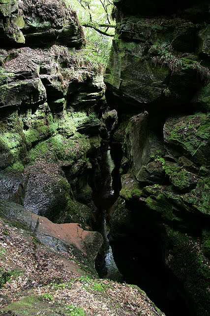
Crichope Linn

Crichope Linn or Crichop Linn, originally Creehope is a gorge and waterfall near Gatelawbridge in Dumfries and Galloway, southern Scotland. Linn is the...

Have you been to Glenbuith?

Leave your review of Glenbuith below (or comments, questions and feedback).