Cwmgwinau

Valley in Glamorgan

Wales

Cwmgwinau

Blaengarw Top of the Garw valley.
Blaengarw Credit: Richard Knights

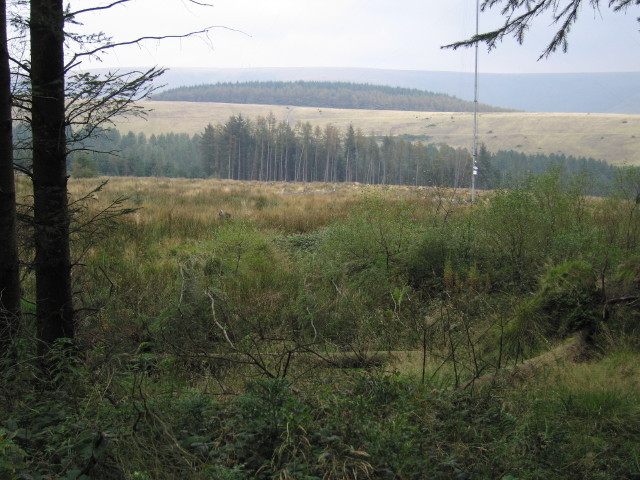
Cwmgwinau is a small village located in the county of Glamorgan, Wales. Situated in the beautiful Glamorgan Valley, the village is known for its picturesque surroundings and tranquil atmosphere. It is nestled among rolling hills and green meadows, offering visitors and residents alike a peaceful and idyllic setting.

The village is home to a close-knit community, with a population of around 300 people. The residents of Cwmgwinau take pride in their village and work together to maintain its charm and character. The houses in the village are predominantly traditional stone cottages, adding to the rural and traditional aesthetic of the area.

Cwmgwinau is surrounded by stunning natural landscapes, making it a popular destination for outdoor enthusiasts. The nearby mountains and forests provide ample opportunities for hiking, cycling, and exploring nature. The area is also known for its rich biodiversity, with various species of flora and fauna calling the valley home.

Although small in size, Cwmgwinau is well-connected to nearby towns and cities. The village has a small shop and a community center, where locals can gather for various events and activities. The nearest town, situated a few miles away, offers additional amenities such as schools, healthcare services, and shopping facilities.

Overall, Cwmgwinau offers a peaceful and scenic lifestyle, attracting those who seek a close connection with nature and a tight-knit community. Its natural beauty and rural charm make it a hidden gem in the heart of Glamorgan Valley.

If you have any feedback on the listing, please let us know in the comments section below.

Cwmgwinau Images

Images are sourced within 2km of 51.627135/-3.5997632 or Grid Reference SS8993. Thanks to Geograph Open Source API. All images are credited.

Blaengarw Top of the Garw valley.
Blaengarw
Top of the Garw valley.
Pontycymmer Fire Station Pontycymmer Fire Station, Victoria Street, Pontycymmer is part of South Wales Fire & Rescue Service
Pontycymmer Fire Station
Pontycymmer Fire Station, Victoria Street, Pontycymmer is part of South Wales Fire & Rescue Service
Coal loading point at Pontycymer During the early 90s this mineral line was re-opened to allow the removal of some open cast coal from the area around Pontycmer. At one time the railway served the colliery at Blaengarw just up the valley. Once the coal had been removed the line was once again mothballed. The mines all closed some years ago.
Coal loading point at Pontycymer
During the early 90s this mineral line was re-opened to allow the removal of some open cast coal from the area around Pontycmer. At one time the railway served the colliery at Blaengarw just up the valley. Once the coal had been removed the line was once again mothballed. The mines all closed some years ago.
Cottages north of Blaengarw Final row of cottages in the valley. Taken next to the bus turning circle.
Cottages north of Blaengarw
Final row of cottages in the valley. Taken next to the bus turning circle.
Blaengarw Post Office Opposite The Strand and Herbert Street junction. Looking in the direction of Pontycymer.
Blaengarw Post Office
Opposite The Strand and Herbert Street junction. Looking in the direction of Pontycymer.
Blaengarw Hotel Large public house on the corner of The Strand, looking towards the head of the valley.
Blaengarw Hotel
Large public house on the corner of The Strand, looking towards the head of the valley.
Police Station  and police van  - Blaengarw
Police Station and police van - Blaengarw
Welsh grazing A fine sweep of Welsh moorland that is grazing for sheep and cows was the first of 8 geographs picked up on a glorious high moorland walk over Mynydd Llangeinwyr.
Welsh grazing
A fine sweep of Welsh moorland that is grazing for sheep and cows was the first of 8 geographs picked up on a glorious high moorland walk over Mynydd Llangeinwyr.
Was it ever pretty? Cwm Garw Fechan was possibly rather pretty before the forestration - but perhaps the collieries had made it ugly before that.
Was it ever pretty?
Cwm Garw Fechan was possibly rather pretty before the forestration - but perhaps the collieries had made it ugly before that.
Good walking Although the rights of way in Garw forest are not easy to follow, there are plenty of forestry tracks that are easy to follow both on the ground and on the map.
Good walking
Although the rights of way in Garw forest are not easy to follow, there are plenty of forestry tracks that are easy to follow both on the ground and on the map.
Sandstone engineering I am not an industrial archaeologist, but this slope looks like reclaimed colliery land. The water channel, laid with sandstone taken from quarries by the side of the forestry tracks, is especially fine: see <a href="https://www.geograph.org.uk/gridref/SS8891">SS8891</a>.
Sandstone engineering
I am not an industrial archaeologist, but this slope looks like reclaimed colliery land. The water channel, laid with sandstone taken from quarries by the side of the forestry tracks, is especially fine: see SS8891.
Striding out A dry (today at least) stream bed runs away immediately left, and there is a track junction ahead.
Striding out
A dry (today at least) stream bed runs away immediately left, and there is a track junction ahead.
Fiveways Paths and tracks run in all directions here: 2 to the right, one to the left, one behind, and one over the stile straight ahead through a field of young rams.
Fiveways
Paths and tracks run in all directions here: 2 to the right, one to the left, one behind, and one over the stile straight ahead through a field of young rams.
Well surfaced Sneaky one on the small section of forestry track that clips the NE corner of this square.
Well surfaced
Sneaky one on the small section of forestry track that clips the NE corner of this square.
Broken down wall On the 1:25000 map, a pair of walls run parallel down the hillside here. One is completely overgrown, and the other - just visible - is ruined. It's worth noting that the track shown on the 1:50000 is not the one that we were on, and is not on the 1:25000.
Broken down wall
On the 1:25000 map, a pair of walls run parallel down the hillside here. One is completely overgrown, and the other - just visible - is ruined. It's worth noting that the track shown on the 1:50000 is not the one that we were on, and is not on the 1:25000.
No trees for a way Both scales of OS map indicate this point is deep in forest, but it clearly isn't. The mast is probably just on the eastern edge of this square, but is not on the 1:25000 map. Just to the left of centre on the slope in the middle distance, can be seen the water channel of <a href="https://www.geograph.org.uk/gridref/SS8992">SS8992</a>.
No trees for a way
Both scales of OS map indicate this point is deep in forest, but it clearly isn't. The mast is probably just on the eastern edge of this square, but is not on the 1:25000 map. Just to the left of centre on the slope in the middle distance, can be seen the water channel of SS8992.
Garw Fechan Winding Down, Garw Forestry Walk
Rock Feature alongside Garw Forestry Walk
Show me another place!

Cwmgwinau is located at Grid Ref: SS8993 (Lat: 51.627135, Lng: -3.5997632)

Unitary Authority: Bridgend

Police Authority: South Wales

What 3 Words

///waltzed.offline.auctioned. Near Pontycymer, Bridgend

Nearby Locations

Cwm Gwyn Cwmgwinau

Related Wikis

Blaengarw railway station

Blaengarw railway station served the village of Blaengarw, in the historical county of Glamorgan, Wales, from 1902 to 1953 on the Garw Valley Railway....
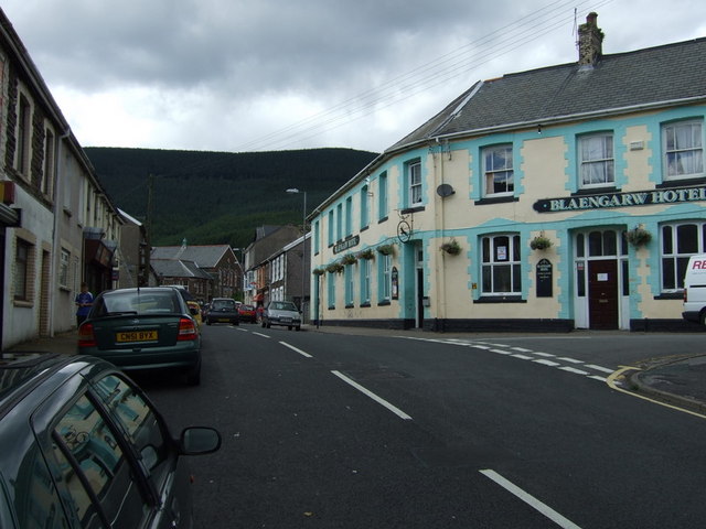
Blaengarw

Blaengarw is the uppermost village in the river valley (Cwm Garw) of the River Garw, in the county borough of Bridgend, Wales. In the English language...

Garw/Ffaldau Colliery

The Garw/Ffaldau Colliery was a colliery formed in 1975 in Pontycymer, Wales. It was formed from the joining together of the Garw Colliery and the Ffaldau...

Pontycymer

Pontycymer, also spelt Pontycymmer, is a former mining village in Wales. It is situated in the Garw Valley, in Bridgend County Borough, about 7 miles or...

Nearby Amenities

Located within 500m of 51.627135,-3.5997632
The data included in this document is from www.openstreetmap.org. The data is made available under ODbL.

Have you been to Cwmgwinau?

Leave your review of Cwmgwinau below (or comments, questions and feedback).