Cwm Cerdin

Valley in Brecknockshire

Wales

Cwm Cerdin

Cwm Irfon, sheep grazing In the Irfon valley.
Cwm Irfon, sheep grazing Credit: Mike Faherty

The requested URL returned error: 429 Too Many Requests

If you have any feedback on the listing, please let us know in the comments section below.

Cwm Cerdin Images

Images are sourced within 2km of 52.146539/-3.651392 or Grid Reference SN8751. Thanks to Geograph Open Source API. All images are credited.
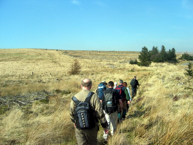
Cwm Irfon, sheep grazing In the Irfon valley.
Cwm Irfon, sheep grazing
In the Irfon valley.
Cwm Irfon, "Help!" A stray sheep on the road from Llanwrtyd to Abergwesyn; local sheep are white, so it does not seem to belong here.
Cwm Irfon, "Help!"
A stray sheep on the road from Llanwrtyd to Abergwesyn; local sheep are white, so it does not seem to belong here.
Pont Nant Cerdin bridge, Llanwrtyd Pont yn rhychwantu Nant Cerdin, Llanwrtyd nad ydyw bellach yn cael ei defnyddio.  Mae'n bosibl i gwrs gwreiddiol y llwybr ceffyl ar un adeg groesi'r bont hon.

A redundant bridge spanning Nant Cerdin (trans. mountain ash stream), Llanwrtyd.  It is possible the bridge formerly carried the original route of the bridleway.
Pont Nant Cerdin bridge, Llanwrtyd
Pont yn rhychwantu Nant Cerdin, Llanwrtyd nad ydyw bellach yn cael ei defnyddio. Mae'n bosibl i gwrs gwreiddiol y llwybr ceffyl ar un adeg groesi'r bont hon. A redundant bridge spanning Nant Cerdin (trans. mountain ash stream), Llanwrtyd. It is possible the bridge formerly carried the original route of the bridleway.
Forest track on the hillside above the Nant Cerdin High above the valley track <a href="https://www.geograph.org.uk/photo/1048574">SN8749 : The Real Ale Wobble heads up the Nant Cerdin</a> used 6 years ago; on this occasion we were shortly treated to a steep & slippery descent back down to a ford.
Forest track on the hillside above the Nant Cerdin
High above the valley track SN8749 : The Real Ale Wobble heads up the Nant Cerdin used 6 years ago; on this occasion we were shortly treated to a steep & slippery descent back down to a ford.
On the east side of the Nant Cerdin The second big climb of the day, and shortly before another highly 'technical' descent down a steep, slippery, muddy, tree-slalom into the valley.
On the east side of the Nant Cerdin
The second big climb of the day, and shortly before another highly 'technical' descent down a steep, slippery, muddy, tree-slalom into the valley.
Back on the flat in the valley A group of slightly shocked riders at the bottom of a very steep & slippery technical descent from the hillside on the left - wet grass, mud, tree stumps & rocks. Brilliant fun, but plenty of opportunity for falling off.
Back on the flat in the valley
A group of slightly shocked riders at the bottom of a very steep & slippery technical descent from the hillside on the left - wet grass, mud, tree stumps & rocks. Brilliant fun, but plenty of opportunity for falling off.
River Irfon Washpool A change from the waterfalls just behind the p.o.v. here the river widens into a tranquil pool. There is a small roadside parking area and some benches to contemplate the river from.
River Irfon Washpool
A change from the waterfalls just behind the p.o.v. here the river widens into a tranquil pool. There is a small roadside parking area and some benches to contemplate the river from.
Waterfalls on river Irfon Just upstream from the washpool the water is much less calm.
Waterfalls on river Irfon
Just upstream from the washpool the water is much less calm.
Standing stones near river Irfon The map says there is a stone here, and there is. If you look hard you can see how the farmer has incorporated it into a hedge.
Standing stones near river Irfon
The map says there is a stone here, and there is. If you look hard you can see how the farmer has incorporated it into a hedge.
The Real Ale Wobble heads up the Nant Cerdin The day was far from ideal for landscape photography, but on a better day, this is a rather attractive little valley where red kites can often be seen. On this occasion, large numbers of cyclists were heading for a wet and muddy experience in the forests.
The Real Ale Wobble heads up the Nant Cerdin
The day was far from ideal for landscape photography, but on a better day, this is a rather attractive little valley where red kites can often be seen. On this occasion, large numbers of cyclists were heading for a wet and muddy experience in the forests.
Pwllgolchu or Washpool on the River Irfon Placid pool in the River Irfon below waterfalls, this pool is presumably named as it was used to wash sheep.
Pwllgolchu or Washpool on the River Irfon
Placid pool in the River Irfon below waterfalls, this pool is presumably named as it was used to wash sheep.
Pwllgolchu or Washpool on the River Irfon Calm pool on the River Irfon.
Pwllgolchu or Washpool on the River Irfon
Calm pool on the River Irfon.
Llwybr Abergwesyn / Abergwesyn path Cerddwyr ar dir uchel yn anelu at bentre Aberfwesyn.

Walkers on high ground heading towards the village of Abergwesyn (trans. river confluence of the little servant [stream]).
Llwybr Abergwesyn / Abergwesyn path
Cerddwyr ar dir uchel yn anelu at bentre Aberfwesyn. Walkers on high ground heading towards the village of Abergwesyn (trans. river confluence of the little servant [stream]).
Banc Paderau Cerddwyr yn dilyn llwybr ceffyl mewn lleoliad a elwir Banc Paderau.

Walkers following a bridleway at a location known as Banc Paderau (hill of prayers).
Banc Paderau
Cerddwyr yn dilyn llwybr ceffyl mewn lleoliad a elwir Banc Paderau. Walkers following a bridleway at a location known as Banc Paderau (hill of prayers).
Tuag at Fanc y Pader / Towards Banc y Pader Cerddwyr yn dilyn llwybr ceffyl ger lleoliad a elwir Banc Paderau.

Walkers following a bridleway at a location known as Banc Paderau (hill of prayers).
Tuag at Fanc y Pader / Towards Banc y Pader
Cerddwyr yn dilyn llwybr ceffyl ger lleoliad a elwir Banc Paderau. Walkers following a bridleway at a location known as Banc Paderau (hill of prayers).
Pwll Y Bo waterfall Near Llanwrtyd Wells
Pwll Y Bo waterfall
Near Llanwrtyd Wells
Craig Dinas Fach An exposed lump of rock right next to the road along the Irfon valley.
Craig Dinas Fach
An exposed lump of rock right next to the road along the Irfon valley.
Picnic Site on the banks of the Irfon
Show me another place!

Cwm Cerdin is located at Grid Ref: SN8751 (Lat: 52.146539, Lng: -3.651392)

Unitary Authority: Powys

Police Authority: Dyfed Powys

What 3 Words

///period.shatters.sleeps. Near Abergwesyn, Powys

Nearby Locations

Crugwydd Cwm Cerdin

Related Wikis

Abergwesyn

Abergwesyn is a village in the Welsh county of Powys, in mid-Wales, at the start of the Abergwesyn valley and at the confluence of the Afon Irfon and the...

Vicarage Meadows

Vicarage Meadows is a Site of Special Scientific Interest near Abergwesyn, Powys, Wales. The 3.6 hectares (8.9 acres) site, located close to the Nant Irfon...

Treflys

Treflys is a community in the county of Powys, Wales, and is 49.9 miles (80.4 km) from Cardiff and 154.4 miles (248.5 km) from London. In 2011 the population...

Llanwrtyd

Llanwrtyd is a small settlement in Powys, mid-Wales, giving its name to a community, in the historic county of Brecknockshire (Breconshire), through which...

Have you been to Cwm Cerdin?

Leave your review of Cwm Cerdin below (or comments, questions and feedback).