Chisel Combe

Valley in Devon North Devon

England

Chisel Combe

Lynton : Foreland Point Looking across towards Foreland Point. The coastline of Wales can be seen in the distance.
Lynton : Foreland Point Credit: Lewis Clarke

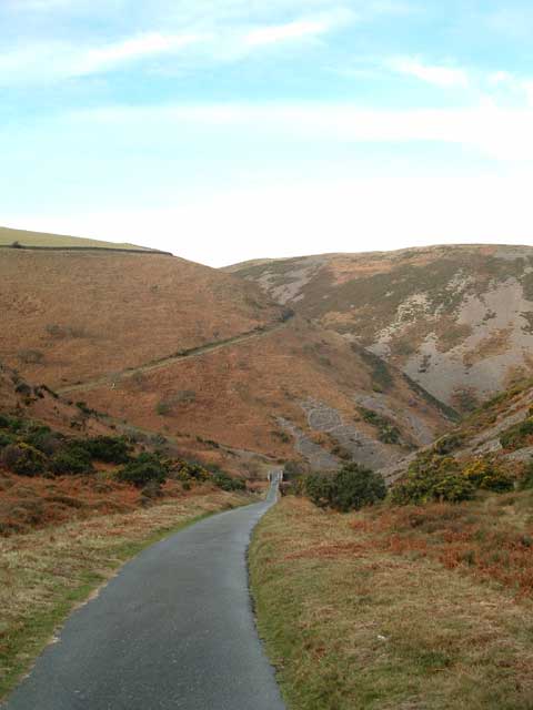
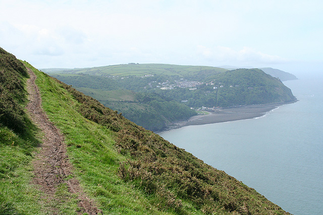
Chisel Combe, located in Devon, England, is a picturesque valley known for its natural beauty and tranquil atmosphere. Situated in the South West of England, this hidden gem is nestled within the Dartmoor National Park, offering visitors a unique and authentic experience of the countryside.

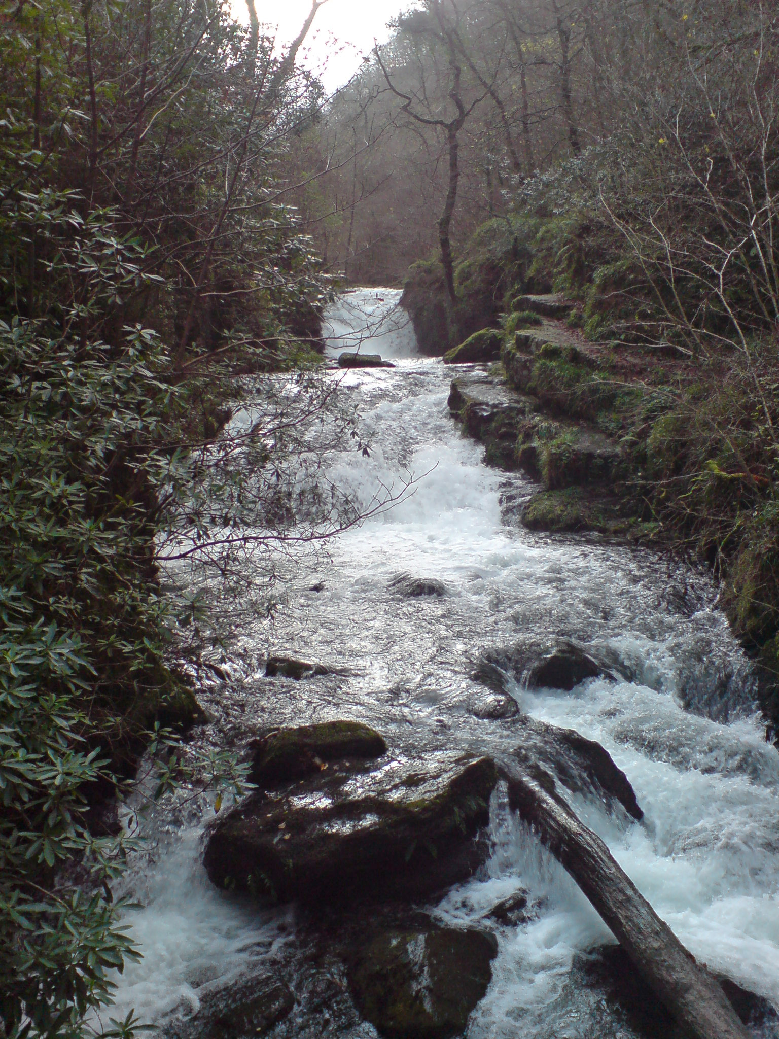
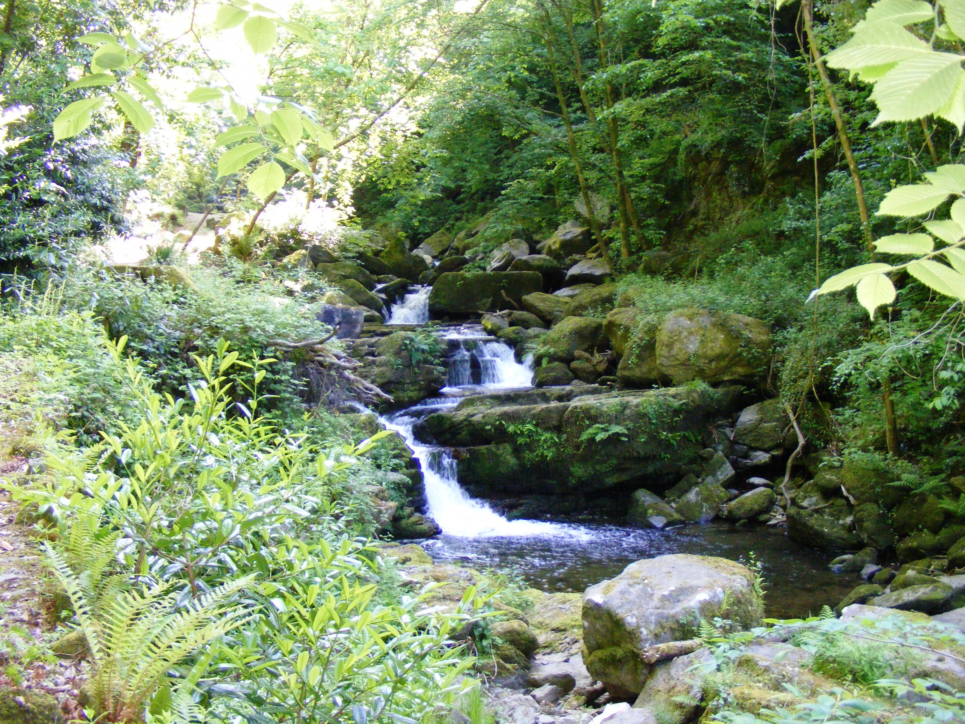
The valley is renowned for its lush green landscapes, rolling hills, and meandering streams that flow through the heart of the village. Chisel Combe is lined with charming, traditional stone cottages, adding to its idyllic charm and providing a glimpse into the region's rich history.

The village is home to a tight-knit community, with a population of around 200 residents. Despite its small size, Chisel Combe boasts a thriving local economy, with a handful of businesses catering to both residents and tourists. Visitors can explore the local shops and cafes, which offer a range of handmade crafts, local produce, and delicious homemade treats.

Outdoor enthusiasts will find plenty to do in Chisel Combe. The valley is a haven for hikers and nature lovers, with numerous walking trails that showcase the area's stunning natural scenery. The nearby Dartmoor National Park offers even more opportunities for exploration, with its rugged landscapes, ancient woodlands, and diverse wildlife.

Chisel Combe is a true haven for those seeking tranquility and a chance to reconnect with nature. Its unspoiled beauty, friendly community, and proximity to Dartmoor National Park make it a must-visit destination for anyone looking to experience the charm of rural Devon.

If you have any feedback on the listing, please let us know in the comments section below.

Chisel Combe Images

Images are sourced within 2km of 51.228875/-3.801338 or Grid Reference SS7449. Thanks to Geograph Open Source API. All images are credited.

Lynton : Foreland Point Looking across towards Foreland Point. The coastline of Wales can be seen in the distance.
Lynton : Foreland Point
Looking across towards Foreland Point. The coastline of Wales can be seen in the distance.
Access Road to Foreland Lighthouse, Devon The access road to Foreland Lighthouse, Devon. The bridge in the photograph also has an Ordnance Survey bench mark.
<a href="https://www.geograph.org.uk/photo/6998704">SS7550 : Ordnance Survey Bench Mark</a>
Access Road to Foreland Lighthouse, Devon
The access road to Foreland Lighthouse, Devon. The bridge in the photograph also has an Ordnance Survey bench mark. SS7550 : Ordnance Survey Bench Mark
Ordnance Survey Bench Mark This mark is located on a bridge that spans the access road to Foreland Lighthouse, Devon. These marks were used by Ordnance Survey for mapping purposes.
<a href="https://www.geograph.org.uk/photo/6998699">SS7550 : Access Road to Foreland Lighthouse, Devon</a>
Ordnance Survey Bench Mark
This mark is located on a bridge that spans the access road to Foreland Lighthouse, Devon. These marks were used by Ordnance Survey for mapping purposes. SS7550 : Access Road to Foreland Lighthouse, Devon
Lynmouth Bay and Foreland Point
Lynton : Foreland Point Looking across towards Foreland Point.
Lynton : Foreland Point
Looking across towards Foreland Point.
Trig pillar on Butter Hill At the peak of Butter Hill is a small telecommunications station and a triangulation pillar.
Trig pillar on Butter Hill
At the peak of Butter Hill is a small telecommunications station and a triangulation pillar.
Butter Hill flush bracket The trig pillar is identified by the flush bracket S5435, with the sight holes at least open to the elements on top of the hill. The station is a third order installation, levelled in 1971.
Butter Hill flush bracket
The trig pillar is identified by the flush bracket S5435, with the sight holes at least open to the elements on top of the hill. The station is a third order installation, levelled in 1971.
Surveying from Butter Hill The triangulation pillar sits on top of Butter Hill; it's clear why as it has great views across Lynmouth Bay and the highlands behind it.
Surveying from Butter Hill
The triangulation pillar sits on top of Butter Hill; it's clear why as it has great views across Lynmouth Bay and the highlands behind it.
Sunset on Butter Hill Although it is over 300m above the steep sea cliffs, the small telecommunications station seems to be rather uninhabited.
Sunset on Butter Hill
Although it is over 300m above the steep sea cliffs, the small telecommunications station seems to be rather uninhabited.
Caddow Combe This little stream is less than a mile long, but it has still managed to carve this 200m deep combe into the sandstones of Foreland Point
Caddow Combe
This little stream is less than a mile long, but it has still managed to carve this 200m deep combe into the sandstones of Foreland Point
View from Foreland Point towards Hurlstone Point Viewed from the South West Coastpath above Caddow Combe.
View from Foreland Point towards Hurlstone Point
Viewed from the South West Coastpath above Caddow Combe.
Countisbury: South West Coast Path by Butter Hill Looking west-south-west towards Lynton and Lynmouth. The track of the cliff railway linking the two communities is visible as a vertical cut through the wooded slopes by the coast
Countisbury: South West Coast Path by Butter Hill
Looking west-south-west towards Lynton and Lynmouth. The track of the cliff railway linking the two communities is visible as a vertical cut through the wooded slopes by the coast
Countisbury: Exmoor mare and foal By Great Red on the public footpath leading to the Foreland and Caddow Combe. Looking north east
Countisbury: Exmoor mare and foal
By Great Red on the public footpath leading to the Foreland and Caddow Combe. Looking north east
Countisbury: Caddow Combe The service road to the lighthouse at Foreland Point runs through the valley. Looking south east from The Foreland
Countisbury: Caddow Combe
The service road to the lighthouse at Foreland Point runs through the valley. Looking south east from The Foreland
Butter Hill TV Relay Station,Trig pillar and Exmoor Ponies The hut may be used as a simple shelter by stranded hikers.
Butter Hill TV Relay Station,Trig pillar and Exmoor Ponies
The hut may be used as a simple shelter by stranded hikers.
Landslide near Foreland Point Lynton and Lynmouth in the background
Landslide near Foreland Point
Lynton and Lynmouth in the background
Exmoor. The Foreland Arch. Climbers passing through the natural rock arch situated below the lighthouse at Foreland Point.
<span class="nowrap"><a title="http://www.flickr.com/photos/exmoor_climber" rel="nofollow ugc noopener" href="http://www.flickr.com/photos/exmoor_climber">Link</a><img style="margin-left:2px;" alt="External link" title="External link - shift click to open in new window" src="https://s1.geograph.org.uk/img/external.png" width="10" height="10"/></span>
Exmoor. The Foreland Arch.
Climbers passing through the natural rock arch situated below the lighthouse at Foreland Point. LinkExternal link
The Gun Caverns. One of five large caves on the beach in this square.
<span class="nowrap"><a title="http://www.flickr.com/photos/exmoor_climber" rel="nofollow ugc noopener" href="http://www.flickr.com/photos/exmoor_climber">Link</a><img style="margin-left:2px;" alt="External link" title="External link - shift click to open in new window" src="https://s1.geograph.org.uk/img/external.png" width="10" height="10"/></span>
The Gun Caverns.
One of five large caves on the beach in this square. LinkExternal link
Show me another place!

Chisel Combe is located at Grid Ref: SS7449 (Lat: 51.228875, Lng: -3.801338)

Administrative County: Devon

District: North Devon

Police Authority: Devon and Cornwall

What 3 Words

///petrified.ivory.trudges. Near Lynton, Devon

Related Wikis

Karpatiosorbus admonitor

Karpatiosorbus admonitor, previously classified as Sorbus admonitor and also called the no parking whitebeam, is a species of whitebeam tree found in Devon...

Wind Hill

Wind Hill, situated close to Lynmouth in Devon, England, is the location of an Iron Age enclosure or "spur" hill fort. The site is effectively a hillside...

Countisbury

Countisbury is a village and former civil parish, now in the parish of Brendon and Countisbury, in the North Devon district, in the county of Devon, England...

Myrtlebury

Myrtlebury is an Iron Age enclosure or 'spur' hill fort situated close to Lynmouth in Devon, England. The fort is effectively the north east of a hillside...

Hoar Oak Water

Hoar Oak Water is a moorland tributary of the East Lyn River in Exmoor, Somerset, England. It rises at Hoaroak Hill in the Chains geological site and flows...
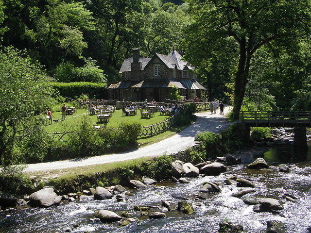
Watersmeet House

Watersmeet House is a National Trust property located some 1.8 miles (2.9 km) east of Lynmouth, in the English county of Devon. A former fishing lodge...
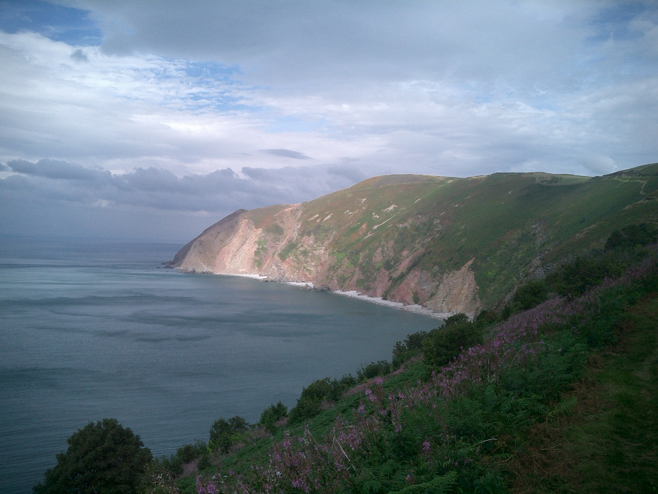
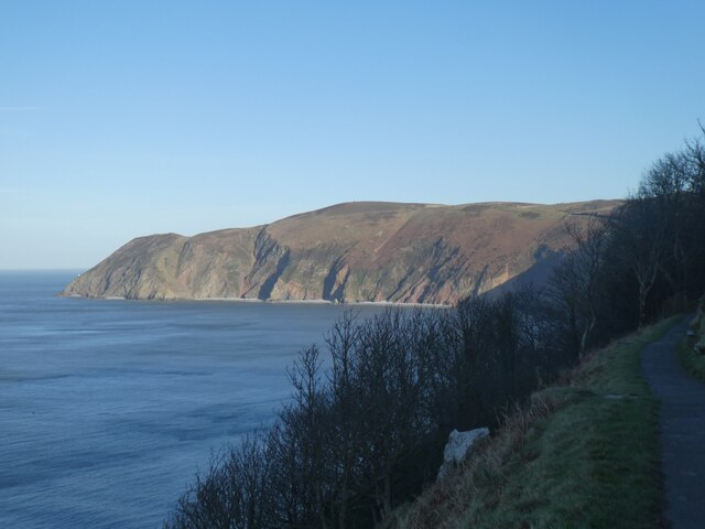
Foreland Point

Foreland Point is a rocky headland in Devon near Lynmouth, and is the most northerly point along the Devon and Exmoor coast. The highest cliff is 89 metres...

West Lyn River

The West Lyn is a river in England which rises high in Exmoor, Somerset, and joins the East Lyn at Lynmouth in Devon. The upper reaches have been designated...

Nearby Amenities

Located within 500m of 51.228875,-3.801338
Wind Hill
Ele: 261
Natural: peak
Source Ele: NPE
Wikidata: Q8023924
Wikipedia: en:Wind Hill
Lat/Long: 51.228924/-3.8064465
Bench
Lat/Long: 51.2319993/-3.8009575
Bench
Lat/Long: 51.230397/-3.8072514
Bench
Backrest: no
Lat/Long: 51.2249835/-3.8038396
Bench
Lat/Long: 51.2259964/-3.8006317
Leisure: picnic_table
Lat/Long: 51.2264353/-3.800725
Bench
Source: survey;gps
Lat/Long: 51.2252401/-3.7985739
Bench
Backrest: no
Survey Date: 2023-05-13
Lat/Long: 51.2262955/-3.800895
Bench
Backrest: no
Survey Date: 2023-05-13
Lat/Long: 51.2273401/-3.8025849
Bench
Backrest: no
Survey Date: 2023-05-13
Lat/Long: 51.2257715/-3.7990281
Leisure: picnic_table
Survey Date: 2023-05-13
Lat/Long: 51.2256815/-3.7988648
Bench
Backrest: no
Survey Date: 2023-05-13
Lat/Long: 51.226286/-3.8043276
The data included in this document is from www.openstreetmap.org. The data is made available under ODbL.

Have you been to Chisel Combe?

Leave your review of Chisel Combe below (or comments, questions and feedback).