Cwm Ffrwd

Valley in Cardiganshire

Wales

Cwm Ffrwd

Minor road leading to Waun-bant The trees on the horizon line the drive to Waun-Bant
Minor road leading to Waun-bant Credit: David Smith

Cwm Ffrwd is a picturesque valley located in the county of Cardiganshire, Wales. Nestled amidst the rolling hills and lush greenery, it is renowned for its natural beauty and tranquility. The valley stretches for approximately 5 miles, encompassing a variety of landscapes ranging from dense woodlands to open meadows.

One of the prominent features of Cwm Ffrwd is the river that meanders through its heart. The river, also named Ffrwd, flows gently, creating a soothing ambiance and providing a habitat for numerous species of wildlife. It is a haven for anglers, as the river is known for its plentiful trout and salmon.

The valley is dotted with several walking trails that offer breathtaking views of the surrounding countryside. Hikers and nature enthusiasts can explore the diverse flora and fauna that thrives in this unspoiled environment. The valley is particularly famous for its vibrant displays of wildflowers during the spring and summer months, creating a colorful tapestry against the backdrop of the hills.

Cwm Ffrwd is also home to an ancient oak woodland, known as Coed Cwm Ffrwd. This woodland is a designated Site of Special Scientific Interest (SSSI) due to its ecological significance. It provides a habitat for various rare species of plants and animals, including the lesser horseshoe bat and the wild service tree.

Overall, Cwm Ffrwd is a hidden gem in Cardiganshire, offering visitors a chance to immerse themselves in the untouched beauty of nature. Whether it's fishing, hiking, or simply enjoying the tranquility, this valley has something to offer for everyone seeking solace in nature.

If you have any feedback on the listing, please let us know in the comments section below.
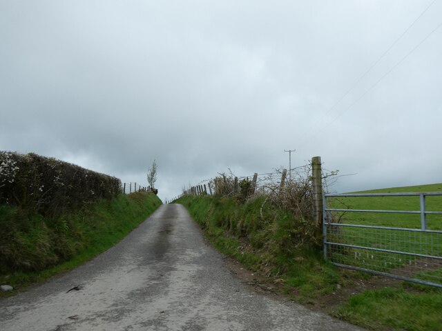
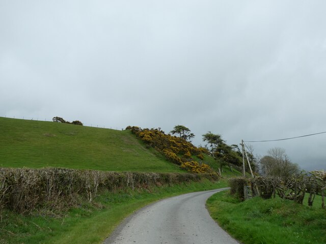
Cwm Ffrwd Images

Images are sourced within 2km of 52.314786/-3.9337435 or Grid Reference SN6870. Thanks to Geograph Open Source API. All images are credited.

Minor road leading to Waun-bant The trees on the horizon line the drive to Waun-Bant
Minor road leading to Waun-bant
The trees on the horizon line the drive to Waun-Bant
Road to Brynarth
Road to Brynarth
Road east of Waun-bant
Grass and gorse above the road near Pantyddafad
A bleak road with deep ditches
Gorse hedges on the roadside banks
Road at Tynllidiart
Road at Tynllidiart
B4340 in Tynygraig
B4340 in Tynygraig
B4340 north of Tynygraig
Pasture and woodland east of Tynygraig, Ceredigion Sheep and horses share the grazing rights this summer.
Pasture and woodland east of Tynygraig, Ceredigion
Sheep and horses share the grazing rights this summer.
Pasture and hillside near Tynygraig, Ceredigion Looking across Cwm Tarw.
Pasture and hillside near Tynygraig, Ceredigion
Looking across Cwm Tarw.
Village and farmland near Tynygraig, Ceredigion This is a telephoto image from a distance of more than six hundred metres. The B4350 disappears to the left towards Pontrhydfendigaid. Housing on the lane leading up the hill to the farm at Penderlwynwen has formed a hamlet of its own south of and separate from Tynygraig village.
Village and farmland near Tynygraig, Ceredigion
This is a telephoto image from a distance of more than six hundred metres. The B4350 disappears to the left towards Pontrhydfendigaid. Housing on the lane leading up the hill to the farm at Penderlwynwen has formed a hamlet of its own south of and separate from Tynygraig village.
Farmland near Tynygraig, Ceredigion Looking towards Tynygraig (off to the left) from the B4340 south of the village. The track bed of the former Manchester and Milford Railway crosses the middle of the picture hidden in the trees.
Farmland near Tynygraig, Ceredigion
Looking towards Tynygraig (off to the left) from the B4340 south of the village. The track bed of the former Manchester and Milford Railway crosses the middle of the picture hidden in the trees.
Pasture and woodland south of Tynygraig, Ceredigion Looking across the valley occupied by Sychnant (which flows to the left towards the Afon Ystwyth), from the B4340 south of the village. The track bed of the former Manchester and Milford Railway crosses the middle of the picture hidden in the trees.
Pasture and woodland south of Tynygraig, Ceredigion
Looking across the valley occupied by Sychnant (which flows to the left towards the Afon Ystwyth), from the B4340 south of the village. The track bed of the former Manchester and Milford Railway crosses the middle of the picture hidden in the trees.
Pasture and hillside south of Tynygraig, Ceredigion The land is by the B4340 (and National Cycle Route 82), which is just off to the left.
Pasture and hillside south of Tynygraig, Ceredigion
The land is by the B4340 (and National Cycle Route 82), which is just off to the left.
Pasture and woodland south of Tynygraig, Ceredigion This is looking across the valley occupied by Sychnant (which flows to the left towards the Afon Ystwyth), from the B4340 south of the village. The track bed of the former Manchester and Milford Railway crosses the middle of the picture beyond the fence and hidden in the trees.
Pasture and woodland south of Tynygraig, Ceredigion
This is looking across the valley occupied by Sychnant (which flows to the left towards the Afon Ystwyth), from the B4340 south of the village. The track bed of the former Manchester and Milford Railway crosses the middle of the picture beyond the fence and hidden in the trees.
Pasture and woodland south of Tynygraig, Ceredigion This is looking from the B4340 south of the village. The track bed of the former Manchester and Milford Railway crosses the middle of the picture at the bottom of the field, mainly hidden in the trees.
Pasture and woodland south of Tynygraig, Ceredigion
This is looking from the B4340 south of the village. The track bed of the former Manchester and Milford Railway crosses the middle of the picture at the bottom of the field, mainly hidden in the trees.
Pasture and woodland south of Tynygraig, Ceredigion This is a telephoto assisted image looking towards Ystradmeurig from the B4340 south of the Tynygraig. The track bed of the former Manchester and Milford Railway crosses the middle of the picture at the bottom of the field, mainly hidden in the trees.
Pasture and woodland south of Tynygraig, Ceredigion
This is a telephoto assisted image looking towards Ystradmeurig from the B4340 south of the Tynygraig. The track bed of the former Manchester and Milford Railway crosses the middle of the picture at the bottom of the field, mainly hidden in the trees.
Show me another place!

Cwm Ffrwd is located at Grid Ref: SN6870 (Lat: 52.314786, Lng: -3.9337435)

Unitary Authority: Ceredigion

Police Authority: Dyfed Powys

What 3 Words

///bugs.veered.fiery. Near Lledrod, Ceredigion

Nearby Locations

Pen-y-bont Wood Cwm Ffrwd

Related Wikis

Caradog Falls Halt railway station

Caradog Falls Halt railway station was one of five new halts on the Carmarthen to Aberystwyth Line (originally called the Manchester and Milford Railway...

Ty'n-y-graig

Ty'n-y-graig is a hamlet in the community of Ystrad Meurig, Ceredigion, Wales, which is 65.3 miles (105.2 km) from Cardiff and 170.7 miles (274.8 km)...

Wenallt

Wenallt is a hamlet in the community of Trawsgoed, Ceredigion, Wales, 10 miles (16 km) southeast of Aberystwyth. Wenallt is represented in the Senedd...

St Afan's Church, Llanafan

Saint Afan's Church (SN68387192) is located in Llanafan, 8 miles (13 km) east of Aberystwyth, Ceredigion, in Wales. == History == The original church on...

Nearby Amenities

Located within 500m of 52.314786,-3.9337435
Place: farm
Lat/Long: 52.3105995/-3.9331485
Ford: yes
Lat/Long: 52.316378/-3.9358995
Ford: yes
Lat/Long: 52.3163153/-3.9388914
Ford: yes
Lat/Long: 52.3170108/-3.9319666
The data included in this document is from www.openstreetmap.org. The data is made available under ODbL.

Have you been to Cwm Ffrwd?

Leave your review of Cwm Ffrwd below (or comments, questions and feedback).