Coire Làir

Valley in Ross-shire

Scotland

Coire Làir

Cona' Mheall summit looking towards Beinn Dearg
Cona' Mheall summit looking towards Beinn Dearg Credit: Steven Brown

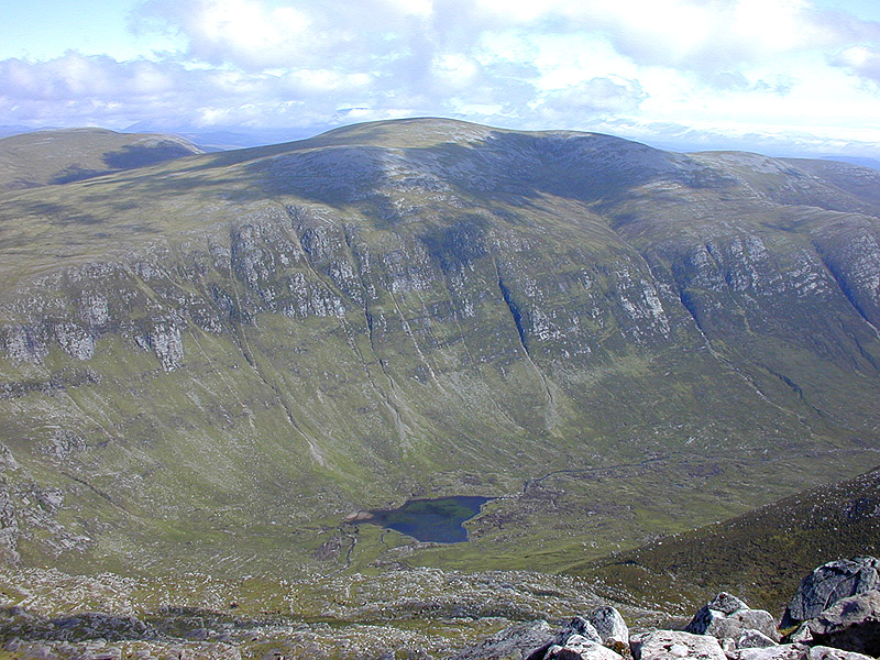
Coire Làir is a stunning valley located in the county of Ross-shire, in the Scottish Highlands of Scotland. Situated amidst the awe-inspiring landscape of the Northern Highlands, this valley is renowned for its natural beauty and picturesque surroundings.

The valley is nestled between towering mountains, with its boundaries defined by steep slopes covered in lush green vegetation. The terrain is predominantly rugged and rocky, with scattered patches of heather and grass. Numerous streams and rivers flow through the valley, originating from the surrounding mountains and adding to the enchanting atmosphere.

Coire Làir is a haven for outdoor enthusiasts and nature lovers. The valley offers a plethora of opportunities for hiking, mountain biking, and birdwatching. The trails and paths that wind through the valley provide breathtaking views of the surrounding peaks and valleys, making it a popular destination for photographers and artists.

Wildlife is abundant in Coire Làir, with many species calling this valley home. Visitors may have the chance to spot red deer, golden eagles, and a variety of smaller birds and mammals. The valley also boasts a diverse range of plant life, including rare alpine flowers and native Scottish trees.

Access to Coire Làir is relatively easy, with a well-maintained road leading to the valley. However, it is important to note that the weather in the Scottish Highlands can be unpredictable, and visitors should come prepared with appropriate clothing and equipment.

Overall, Coire Làir is a natural gem that showcases the raw beauty of the Scottish Highlands. Its stunning landscapes, abundant wildlife, and recreational opportunities make it an ideal destination for those seeking a true Highland experience.

If you have any feedback on the listing, please let us know in the comments section below.

Coire Làir Images

Images are sourced within 2km of 57.777735/-4.8840575 or Grid Reference NH2880. Thanks to Geograph Open Source API. All images are credited.

Cona' Mheall summit looking towards Beinn Dearg
Loch Prille Taken from the summit of Cona Mheall
Loch Prille
Taken from the summit of Cona Mheall
Beinn Dhearg from Am Faochagach The mountain gives a good view into Choire Ghranda and its glacial loch.  The coire is one of Scotland's best examples of the action of a coire glacier.
Beinn Dhearg from Am Faochagach
The mountain gives a good view into Choire Ghranda and its glacial loch. The coire is one of Scotland's best examples of the action of a coire glacier.
Cona Mheall A summer's evening on the eastern ridge running down from Ceann Garbh.
Cona Mheall
A summer's evening on the eastern ridge running down from Ceann Garbh.
Loch a' Choire Ghrànda Corrie between Beinn Dearg and Cona Mheall
Loch a' Choire Ghrànda
Corrie between Beinn Dearg and Cona Mheall
A pause on the eastern slope of Cona' Mheal Not far below the summit, confirmed by Nigel Brown's summit picture <a href="https://www.geograph.org.uk/photo/1026696">NH2781 : View east from Cona' Mheall</a> which was climbed soon after.  The party's campsite on Loch Prille <a href="https://www.geograph.org.uk/photo/598400">NH2881 : Loch Prille</a> is visible as an orange blob by the frozen snow-covered loch.
A pause on the eastern slope of Cona' Mheal
Not far below the summit, confirmed by Nigel Brown's summit picture NH2781 : View east from Cona' Mheall which was climbed soon after. The party's campsite on Loch Prille NH2881 : Loch Prille is visible as an orange blob by the frozen snow-covered loch.
Coire Ghranda and Beinn Dearg from the Am Faochagach ridge A halt on the descent of Am Faochagach to examine the hill climbed the day before and also to take in the view towards the Fannichs climbed the previous Easter, <a href="https://www.geograph.org.uk/photo/597667">NH2978 : Southwestern slope of Am Faochagach</a>.
Coire Ghranda and Beinn Dearg from the Am Faochagach ridge
A halt on the descent of Am Faochagach to examine the hill climbed the day before and also to take in the view towards the Fannichs climbed the previous Easter, NH2978 : Southwestern slope of Am Faochagach.
View west from Cona' Mheall With Beinn Dearg filling the left hand side of the picture, Meall nan Ceapraichean on the right, and a hazy An Teallach in the distance.
View west from Cona' Mheall
With Beinn Dearg filling the left hand side of the picture, Meall nan Ceapraichean on the right, and a hazy An Teallach in the distance.
Loch a' Choire Ghranda, Beinn Dearg Victorian writers used to describe cliffs like these as , "beetling crags". Very evocative as they loom over the lochan. Beinn Dearg is the skyline lump on the left
Loch a' Choire Ghranda, Beinn Dearg
Victorian writers used to describe cliffs like these as , "beetling crags". Very evocative as they loom over the lochan. Beinn Dearg is the skyline lump on the left
Conival summit with Seanna Bhraigh An overcast day but with spectacular views. The Cadha Dearg and Creag an Duine show up well.
Conival summit with Seanna Bhraigh
An overcast day but with spectacular views. The Cadha Dearg and Creag an Duine show up well.
Conival summit Together with <a href="https://www.geograph.org.uk/photo/2777514">NH2781 : Conival summit with Seanna Bhraigh</a> and <a href="https://www.geograph.org.uk/photo/2777552">NH2781 : Conival summit</a> this view completes the northern view from the boulder and mossy grass covered summit of Conival. The skyline hills this time are, from left to right, Cul Mor, Suilven, Canisp and Quinaig with the Ben Mor Assynt group in the distant far right.
Conival summit
Together with NH2781 : Conival summit with Seanna Bhraigh and NH2781 : Conival summit this view completes the northern view from the boulder and mossy grass covered summit of Conival. The skyline hills this time are, from left to right, Cul Mor, Suilven, Canisp and Quinaig with the Ben Mor Assynt group in the distant far right.
Summit of Cona' Mheall Creag an Duine is the peak on the left and Ben Klibreck centre horizon.
Summit of Cona' Mheall
Creag an Duine is the peak on the left and Ben Klibreck centre horizon.
Loch Prille from the top of Cona' Mheall
South ridge of Cona' Mheall from the summit
The bare north flank of Am Faochagach It may be featureless, but deer and moorland birds are happy here in summer.
The bare north flank of Am Faochagach
It may be featureless, but deer and moorland birds are happy here in summer.
Cairn atop Am Faochagach
Just east of the summit of Meallan Ban Mist, low cloud, looking into the glen of the Allt a Chrom-uillt.
Just east of the summit of Meallan Ban
Mist, low cloud, looking into the glen of the Allt a Chrom-uillt.
North col of Am Faochagach A cloudy day on the north side of Am Faochagach.
North col of Am Faochagach
A cloudy day on the north side of Am Faochagach.
Show me another place!

Coire Làir is located at Grid Ref: NH2880 (Lat: 57.777735, Lng: -4.8840575)

Unitary Authority: Highland

Police Authority: Highlands and Islands

What 3 Words

///inflame.mistress.brilliant. Near Ullapool, Highland

Nearby Locations

Coire Làir Loch na Still

Related Wikis

Cona' Mheall

Cona' Mheall (978 m) is a mountain in the Northwest Highlands of Scotland. It is located near Ullapool in Wester Ross. Taking the form of a fine rocky...

Am Faochagach

Am Faochagach (953 m) is a mountain in the Northwest Highlands of Scotland. It is located in Wester Ross, north of the main road to Ullapool. A rounded...

Beinn Dearg (Ullapool)

Beinn Dearg (one of a number of Scottish hills of that name) is a mountain in the Inverlael area of the Highlands of Scotland. It is most frequently climbed...

Beinn Enaiglair

Beinn Enaiglair (890 m) is a mountain in Wester Ross, Scotland. It lies in the Northwest Highlands. An outlier of the Beinn Dearg range, it is a mountain...

Eas Fionn

Eas Fionn is a waterfall of Scotland. == See also == Waterfalls of Scotland == References ==

Ross-shire

Ross-shire (; Scottish Gaelic: Siorrachd Rois) is a historic county in the Scottish Highlands. The county borders Sutherland to the north and Inverness...

Seana Bhràigh

Seana Bhràigh is a mountain east of Ullapool, in the Highlands of Scotland. == Ascent == The main approach is from the A835 road through the Lael Forest...

Loch Glascarnoch

Loch Glascarnoch is a 7-kilometre-long (4.3 mi) reservoir in the highlands of Scotland between Ullapool and Inverness. It is dammed on its eastern end...

Have you been to Coire Làir?

Leave your review of Coire Làir below (or comments, questions and feedback).