Gardyloo Gully

Valley in Inverness-shire

Scotland

Gardyloo Gully

Bealach Cumhann Between Ben Nevis and Meall Cumhann. Gives a glimpse of Aonach Beag, or at least the cloud its hiding in.
Bealach Cumhann Credit: Richard Webb

Gardyloo Gully, located in Inverness-shire, Scotland, is a breathtaking valley renowned for its natural beauty and unique geological features. Nestled within the Scottish Highlands, this picturesque gully offers visitors an idyllic escape into the heart of nature.

The valley gets its name from the Scottish term "gardyloo," which was historically used as a warning cry to alert those below of the disposal of waste from the upper floors of buildings. While the origin of this name in relation to the valley remains uncertain, it adds an intriguing historical aspect to the area.

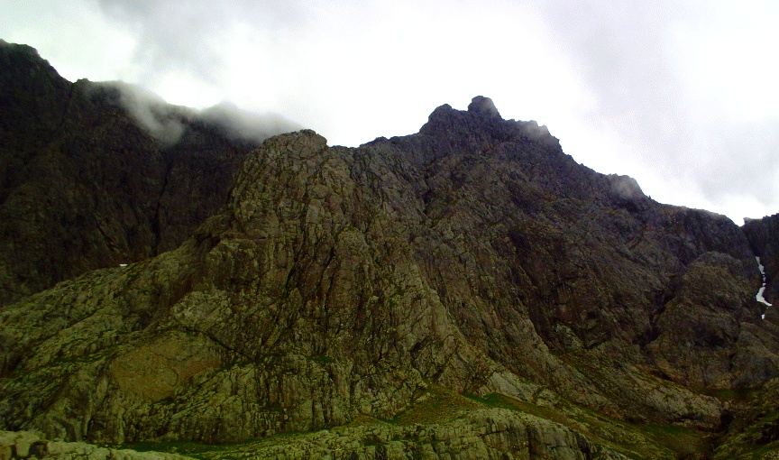
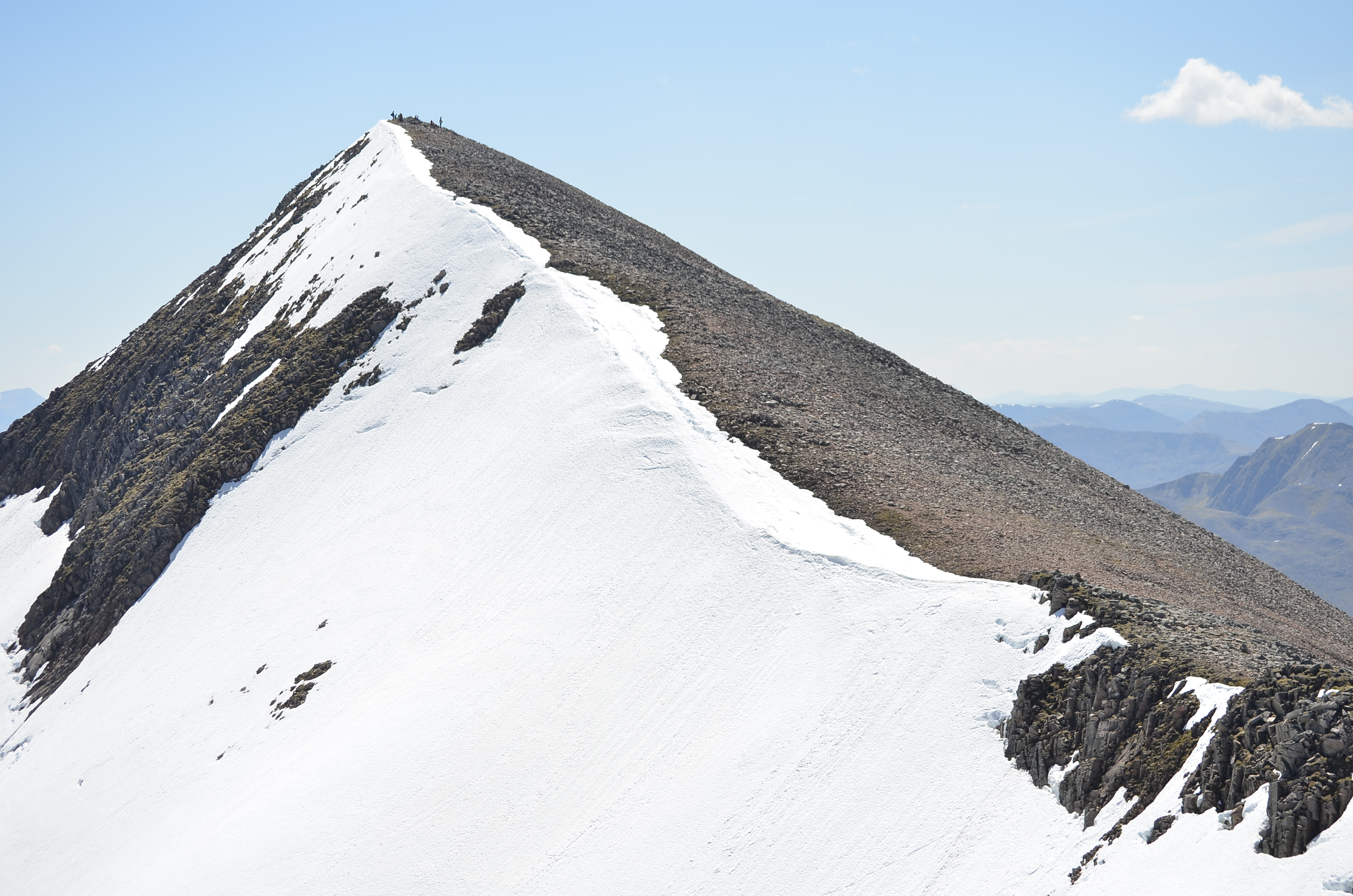
Gardyloo Gully is characterized by its steep slopes, lush greenery, and meandering river that runs through its center. The valley is flanked by towering mountains on either side, providing a dramatic backdrop to the landscape. This rugged terrain is a haven for outdoor enthusiasts, offering opportunities for hiking, mountain biking, and wildlife spotting.

The vegetation in Gardyloo Gully is diverse and abundant, with heather, ferns, and various wildflowers carpeting the valley floor. This rich flora supports a wide range of wildlife, including red deer, golden eagles, and elusive pine martens. Birdwatchers will delight in the presence of numerous species, such as ospreys, peregrine falcons, and Scottish crossbills.

In addition to its natural beauty, the valley also boasts several historical and cultural attractions. Ruins of ancient settlements, stone circles, and burial sites can be found scattered throughout the area, providing a glimpse into the region's fascinating past.

Overall, Gardyloo Gully is a captivating destination that offers visitors an unforgettable experience of Scotland's untamed wilderness and its rich history.

If you have any feedback on the listing, please let us know in the comments section below.

Gardyloo Gully Images

Images are sourced within 2km of 56.796982/-5.0049146 or Grid Reference NN1671. Thanks to Geograph Open Source API. All images are credited.

Bealach Cumhann Between Ben Nevis and Meall Cumhann. Gives a glimpse of Aonach Beag, or at least the cloud its hiding in.
Bealach Cumhann
Between Ben Nevis and Meall Cumhann. Gives a glimpse of Aonach Beag, or at least the cloud its hiding in.
Allt Coire Eoghainn Waterfall in Glen Nevis
Allt Coire Eoghainn
Waterfall in Glen Nevis
The Glen Nevis waterslide Swollen by recent showers, the Allt Coire Eoghainn streaks down into the glen.
The Glen Nevis waterslide
Swollen by recent showers, the Allt Coire Eoghainn streaks down into the glen.
Waterfall in Glen Nevis
Glen Nevis: waterfall on south side of Ben Nevis Looking up from the car park at the very end of the road through the glen.
Glen Nevis: waterfall on south side of Ben Nevis
Looking up from the car park at the very end of the road through the glen.
Waterfall from the car park at the end of the road in Glen Nevis
Upper part of the Allt Coire Eoghainn waterslide The Allt Coire Eoghainn drops over 450m in 1km horizontal distance at a fairly uniform gradient, tumbling down slabby rocks on the lower slopes of Ben Nevis.
Upper part of the Allt Coire Eoghainn waterslide
The Allt Coire Eoghainn drops over 450m in 1km horizontal distance at a fairly uniform gradient, tumbling down slabby rocks on the lower slopes of Ben Nevis.
Allt Coire Eoghainn and Carn Dearg
Allt Coire Eoghainn coming down the hillside From the upper car park on the path through the Glen Nevis gorge looking back to Allt Coire Eoghainn coming down the hillside
Allt Coire Eoghainn coming down the hillside
From the upper car park on the path through the Glen Nevis gorge looking back to Allt Coire Eoghainn coming down the hillside
Bealach Cumhann Looking to the Mamores.
Bealach Cumhann
Looking to the Mamores.
Allt Coire Eoghainn Allt Coire Eoghainn creates a white carcade down in to Glen Nevis
Allt Coire Eoghainn
Allt Coire Eoghainn creates a white carcade down in to Glen Nevis
Glen Nevis From the footpath as it passes through the woodland, a brief glimpse of the falls at Allt Coire Eòghainn and Carn Dearg.
Glen Nevis
From the footpath as it passes through the woodland, a brief glimpse of the falls at Allt Coire Eòghainn and Carn Dearg.
Allt Coire Eoghainn
Allt Coire Eoghainn
Allt Coire Eoghainn Water cascading down from the corrie
Allt Coire Eoghainn
Water cascading down from the corrie
The waterslide, Allt Coire Eoghainn
Allt Coire Eoghainn (waterfall)
Carn Dearg In addition to the 1344m summit, there are several other summits on Ben Nevis. This steep craggy hill above Glen Nevis is the southern Carn Dearg, a rarely visited outlier.
Carn Dearg
In addition to the 1344m summit, there are several other summits on Ben Nevis. This steep craggy hill above Glen Nevis is the southern Carn Dearg, a rarely visited outlier.
Allt Coire Eoghainn
Allt Coire Eoghainn
Show me another place!

Gardyloo Gully is located at Grid Ref: NN1671 (Lat: 56.796982, Lng: -5.0049146)

Unitary Authority: Highland

Police Authority: Highlands and Islands

What 3 Words

///speeded.minder.removal. Near Fort William, Highland

Related Wikis

Ben Nevis

Ben Nevis ( NEV-iss; Scottish Gaelic: Beinn Nibheis, Scottish Gaelic pronunciation: [pe(ɲ) ˈɲivɪʃ]) is the highest mountain in Scotland, the United Kingdom...

Tower Ridge

Tower Ridge is one of several ridges protruding north east from the summit plateau of Ben Nevis, the highest mountain in the United Kingdom. == Technical... ==

Càrn Mòr Dearg

Càrn Mòr Dearg (Scottish Gaelic for 'great red peak') is the ninth-highest mountain in Scotland and the British Isles, with a height of 1,220 metres (4...

Aonach Beag

Aonach Beag is a mountain in the Scottish Highlands. It is located about 3 km east of Ben Nevis on the north side of Glen Nevis, near the town of Fort...

Nearby Amenities

Located within 500m of 56.796982,-5.0049146
Ben Nevis
Description: Possibly from an old Gaelic word meaning venomous
Ele: 1345
Importance: national
Man Made: survey_point
Marilyn: yes
Munro: yes
Munro Number: M001
Name Gd: Beinn Nibheis
Name Zh: 本尼维斯山
Natural: peak
Prominence: 1345
Source Ele: http://www.bbc.co.uk/news/science-environment-35837773
Source Prominence: Highest peak of Great Britain Island
Wheelchair: no
Wikidata: Q104674
Wikipedia: en:Ben Nevis
Lat/Long: 56.7968582/-5.003526
Tourism: viewpoint
Wheelchair: no
Lat/Long: 56.796712/-5.0037061
number 3 Gardyloo
Landmark: cairn
Man Made: cairn
Ref: 3
Source: survey
Lat/Long: 56.7958963/-5.0053716
number 1
Landmark: cairn
Man Made: cairn
Ref: 1
Source: survey
Lat/Long: 56.7965257/-5.0041779
number 2
Landmark: cairn
Man Made: cairn
Ref: 2
Source: survey
Lat/Long: 56.7962767/-5.0045662
number 3a
Landmark: cairn
Man Made: cairn
Ref: 3a
Source: survey
Lat/Long: 56.7961989/-5.0047761
number 3b
Landmark: cairn
Man Made: cairn
Ref: 3b
Source: survey
Lat/Long: 56.7959742/-5.0061628
number 4
Landmark: cairn
Man Made: cairn
Ref: 4
Source: survey
Lat/Long: 56.796027/-5.0069836
Gardyloo Gully
Place: locality
Source: survey; local
Lat/Long: 56.7966304/-5.0051985
No 2 Gully
Natural: gully
Place: locality
Source: OS_OpenData_StreetView
Lat/Long: 56.7976586/-5.0113461
North East Buttress
Place: locality
Source: OS_OpenData_StreetView
Lat/Long: 56.7985164/-4.9981067
Observatory Gully
Place: locality
Source: OS_OpenData_StreetView
Lat/Long: 56.7991391/-5.0031278
The Daradh
Place: locality
Source: OS_OpenData_StreetView
Lat/Long: 56.8000674/-5.0083503
Tower Gully
Place: locality
Source: OS_OpenData_StreetView
Lat/Long: 56.7969138/-5.0063955
Great Tower
Place: locality
Source: OS_OpenData_StreetView
Lat/Long: 56.7983927/-5.0064059
The Comb
Place: locality
Source: OS_OpenData_StreetView
Lat/Long: 56.7987998/-5.0121486
Scottish Highlands
Fixme: make relation
Is In Country: United Kingdom
Is In Country Code: GB
Name Cs: Skotská vysočina
Name En: Scottish Highlands
Natural: mountain_range
Short Name: Highlands
Wikidata: Q106652
Wikipedia: en:Scottish Highlands
Lat/Long: 56.8/-5
Landmark: cairn
Man Made: cairn
Source: bing
Lat/Long: 56.7959235/-5.0053065
Landmark: cairn
Man Made: cairn
Source: bing
Lat/Long: 56.7959007/-5.0054526
Landmark: cairn
Man Made: cairn
Source: bing
Lat/Long: 56.7966161/-5.0124237
Landmark: cairn
Man Made: cairn
Source: bing
Lat/Long: 56.7965191/-5.0117853
Landmark: cairn
Man Made: cairn
Source: bing
Lat/Long: 56.7963223/-5.0102779
Landmark: cairn
Man Made: cairn
Source: bing
Lat/Long: 56.7962445/-5.0094196
Landmark: cairn
Man Made: cairn
Source: bing
Lat/Long: 56.7961725/-5.0086203
Landmark: cairn
Man Made: cairn
Source: bing
Lat/Long: 56.7960946/-5.0078049
Tourism: viewpoint
Lat/Long: 56.7969329/-5.0036477
The data included in this document is from www.openstreetmap.org. The data is made available under ODbL.

Have you been to Gardyloo Gully?

Leave your review of Gardyloo Gully below (or comments, questions and feedback).