The Chasm of an t-Sròn

Valley in Argyllshire

Scotland

The Chasm of an t-Sròn

Clachaig Inn, Glencoe A very famous inn situated in the heart of Glencoe, popular with climbers and walkers.
Clachaig Inn, Glencoe Credit: Euan Nelson

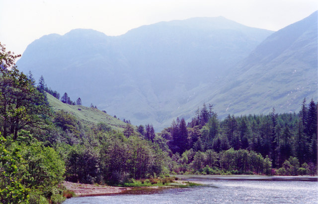
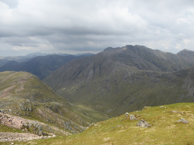
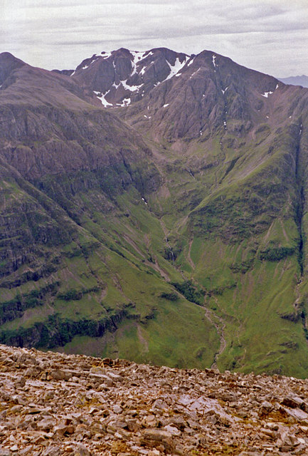
The Chasm of an t-Sròn, located in Argyllshire, Scotland, is a deep valley surrounded by rugged cliffs and lush vegetation. The valley is known for its dramatic landscape, with steep rock walls that drop down into a narrow gorge below. The chasm is carved by a fast-flowing river that cuts through the rocky terrain, creating a stunning natural feature that attracts visitors from around the world.

The Chasm of an t-Sròn offers visitors the opportunity to explore the rugged beauty of the Scottish Highlands, with hiking trails that wind through the valley and up to panoramic viewpoints overlooking the gorge. The valley is home to a diverse range of plant and animal species, making it a popular destination for nature enthusiasts and wildlife photographers.

In addition to its natural beauty, The Chasm of an t-Sròn has a rich cultural history, with ancient ruins and archaeological sites scattered throughout the valley. Visitors can learn about the area's past through guided tours and interpretive signs that highlight the significance of this unique landscape. Whether you are seeking adventure or relaxation, The Chasm of an t-Sròn offers a truly unforgettable experience in the heart of Scotland's wild and rugged terrain.

If you have any feedback on the listing, please let us know in the comments section below.

The Chasm of an t-Sròn Images

Images are sourced within 2km of 56.655283/-5.0428095 or Grid Reference NN1355. Thanks to Geograph Open Source API. All images are credited.

Clachaig Inn, Glencoe A very famous inn situated in the heart of Glencoe, popular with climbers and walkers.
Clachaig Inn, Glencoe
A very famous inn situated in the heart of Glencoe, popular with climbers and walkers.
The old Glencoe road, Clachaig Inn The old Glencoe road begins in Glencoe village and joins the A82. The mountain towering in the distance is the 892m high Aonach Dubh.
The old Glencoe road, Clachaig Inn
The old Glencoe road begins in Glencoe village and joins the A82. The mountain towering in the distance is the 892m high Aonach Dubh.
Signal Rock, Glencoe Signal Rock caps the minor eminence of Tom a'Ghrianain ("Hill of the Sun").  According to tradition, the MacDonalds of Glencoe gathered here in times of crisis, and some assert that a fire was lit here to signal the start of the Massacre on 13 February 1692.  However, there is no evidence to support this.
Signal Rock, Glencoe
Signal Rock caps the minor eminence of Tom a'Ghrianain ("Hill of the Sun"). According to tradition, the MacDonalds of Glencoe gathered here in times of crisis, and some assert that a fire was lit here to signal the start of the Massacre on 13 February 1692. However, there is no evidence to support this.
River Coe, Glencoe
River Coe, Glencoe
Search and Rescue helicopter contouring Sgorr nam Fiannaidh This was flying around at times for several days. As the rescue service was being passed from the RAF to Briscoe at the time, these may have been training and familiarisation exercises.
Search and Rescue helicopter contouring Sgorr nam Fiannaidh
This was flying around at times for several days. As the rescue service was being passed from the RAF to Briscoe at the time, these may have been training and familiarisation exercises.
Coire nan Lochan A popular Winter climbing crag.  It is obvious that the gullies were not in the best condition, ready to avalanche and later on I set one off on Dorsal Arete with a big chunk of windslab coming off from a fracture line just below my axes.  If you were in Broad Gully - sorry.
Coire nan Lochan
A popular Winter climbing crag. It is obvious that the gullies were not in the best condition, ready to avalanche and later on I set one off on Dorsal Arete with a big chunk of windslab coming off from a fracture line just below my axes. If you were in Broad Gully - sorry.
East ridge of Stob Coire nan Lochan The ridge forms the skyline of the Coire nan Lochan climbing crags and is the ridge which terminates at Aonach Dubh.
East ridge of Stob Coire nan Lochan
The ridge forms the skyline of the Coire nan Lochan climbing crags and is the ridge which terminates at Aonach Dubh.
Summit, Stob Coire nan Lochan Bidean nan Bian's best known top.  Taken after an ascent of Dorsal Arete.
Summit, Stob Coire nan Lochan
Bidean nan Bian's best known top. Taken after an ascent of Dorsal Arete.
Stob Coire nan Lochan A major summit of the Bidean nan Bian and connected with the parent summit by a fine ridge.  The hidden face is a fine corrie with many good Winter routes.
Stob Coire nan Lochan
A major summit of the Bidean nan Bian and connected with the parent summit by a fine ridge. The hidden face is a fine corrie with many good Winter routes.
Bidean nan Bian The massive hill on the south side of Glen Coe.  A view from Stob Coire nan Lochan towards the highest top with the Church Door Buttress on the right of the connecting ridge.
Bidean nan Bian
The massive hill on the south side of Glen Coe. A view from Stob Coire nan Lochan towards the highest top with the Church Door Buttress on the right of the connecting ridge.
Glen Coe: SE on Old Road near Clachaig Hotel View before crossing to the A82 trunk road on the south side of the River Coe. Ahead are Aonach Dubh (2,849 ft.) and Beinn Fhada (peaking at 3,497 ft.). (Cf. <a href="https://www.geograph.org.uk/photo/13893">NN1257 : Glen Coe</a>).
Glen Coe: SE on Old Road near Clachaig Hotel
View before crossing to the A82 trunk road on the south side of the River Coe. Ahead are Aonach Dubh (2,849 ft.) and Beinn Fhada (peaking at 3,497 ft.). (Cf. NN1257 : Glen Coe).
Meall Mor from Glen Coe near Clachaig Hotel Southward view to Meall Mor (2,215 ft.).
Meall Mor from Glen Coe near Clachaig Hotel
Southward view to Meall Mor (2,215 ft.).
Stob Coire nan Lochan The summit area of Stob Coire nan Lochan, with the Aonach Eagach and Mamores visible beyond Glencoe.
Stob Coire nan Lochan
The summit area of Stob Coire nan Lochan, with the Aonach Eagach and Mamores visible beyond Glencoe.
Coire nan Lochan A view from the upper region of Coire nan Lochan over the flank of Gearr Aonach. The A82 road leading towards the Pass of Glencoe can be seen in the distance.
Coire nan Lochan
A view from the upper region of Coire nan Lochan over the flank of Gearr Aonach. The A82 road leading towards the Pass of Glencoe can be seen in the distance.
Buttress on north ridge of Stob Coire nan Lochan Cliffs on Stob Coire nan Lochan's north ridge, which is snow covered in early March.
Buttress on north ridge of Stob Coire nan Lochan
Cliffs on Stob Coire nan Lochan's north ridge, which is snow covered in early March.
Bidean nam Bian A view from Stob an Fhuarain, taking in the less frequently-visited side of Bidean nam Bian, and part of the ridge joining it with Beinn Maol Chaluim.
Bidean nam Bian
A view from Stob an Fhuarain, taking in the less frequently-visited side of Bidean nam Bian, and part of the ridge joining it with Beinn Maol Chaluim.
Aonach Eagach from Glean-leac-na-muidhe Looking directly towards the Clachaig Gully, with its infamously dangerous steep path alongside.
Aonach Eagach from Glean-leac-na-muidhe
Looking directly towards the Clachaig Gully, with its infamously dangerous steep path alongside.
Show me another place!

The Chasm of an t-Sròn is located at Grid Ref: NN1355 (Lat: 56.655283, Lng: -5.0428095)

Unitary Authority: Highland

Police Authority: Highlands and Islands

What 3 Words

///teeth.trapdoor.factually. Near Glencoe, Highland

Related Wikis

Loch Achtriochtan

Loch Achtriochtan or Loch Trychardan is a small shallow freshwater loch located to the east of Glencoe village in Lochaber in the Scottish Highlands. It...

Clachaig Inn

The Clachaig Inn is a hotel and pub in Glen Coe, Lochaber, Highland, Scotland. It is popular with walkers and climbers who come to visit the surrounding...

Bidean nam Bian

Bidean nam Bian (Scottish Gaelic: Bidean nam Beann, "peak of the mountains") is the highest peak in a group of mountains south of Glen Coe and north of...

Aonach Eagach

The Aonach Eagach (Scottish Gaelic for 'notched ridge') is a large mountain ridge in the Scottish Highlands, marking the northern edge of Glen Coe. It...

Nearby Amenities

Located within 500m of 56.655283,-5.0428095
An t-Sròn
Natural: peak
Lat/Long: 56.651259/-5.0451257
The Chasm of An t-Sron
Place: locality
Lat/Long: 56.6553898/-5.0429609
The data included in this document is from www.openstreetmap.org. The data is made available under ODbL.

Have you been to The Chasm of an t-Sròn?

Leave your review of The Chasm of an t-Sròn below (or comments, questions and feedback).