Gleann Leac na Muidhe

Valley in Argyllshire

Scotland

Gleann Leac na Muidhe

Cairn on Meall Mòr The cairn marks the direction of an easy way off Meall Mòr which is a very steep hill. It is quite an old cairn, probably erected by shepherds. The level ridge runs past the snow patch to the summit, perched on the edge of the Glen Coe cauldron subsidence.
Cairn on Meall Mòr Credit: Richard Webb

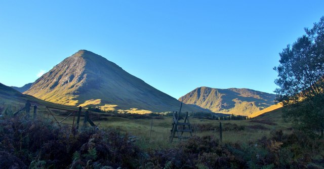
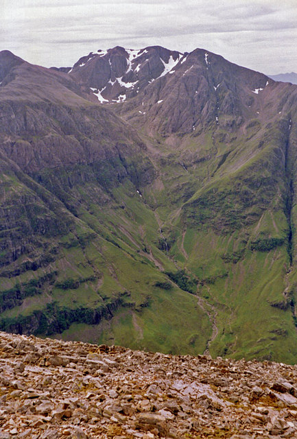
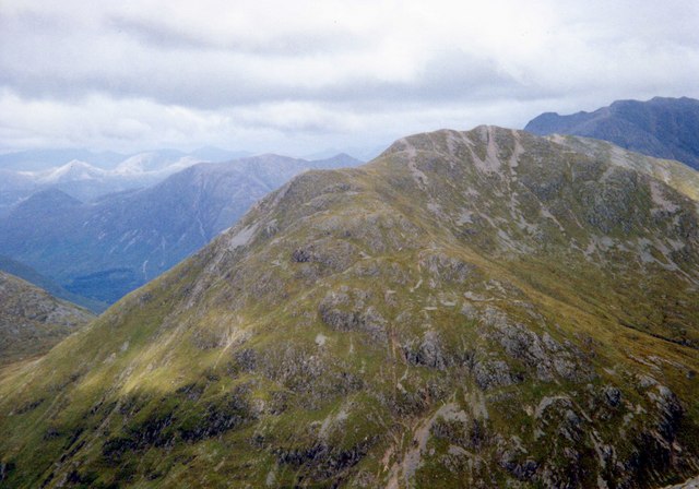
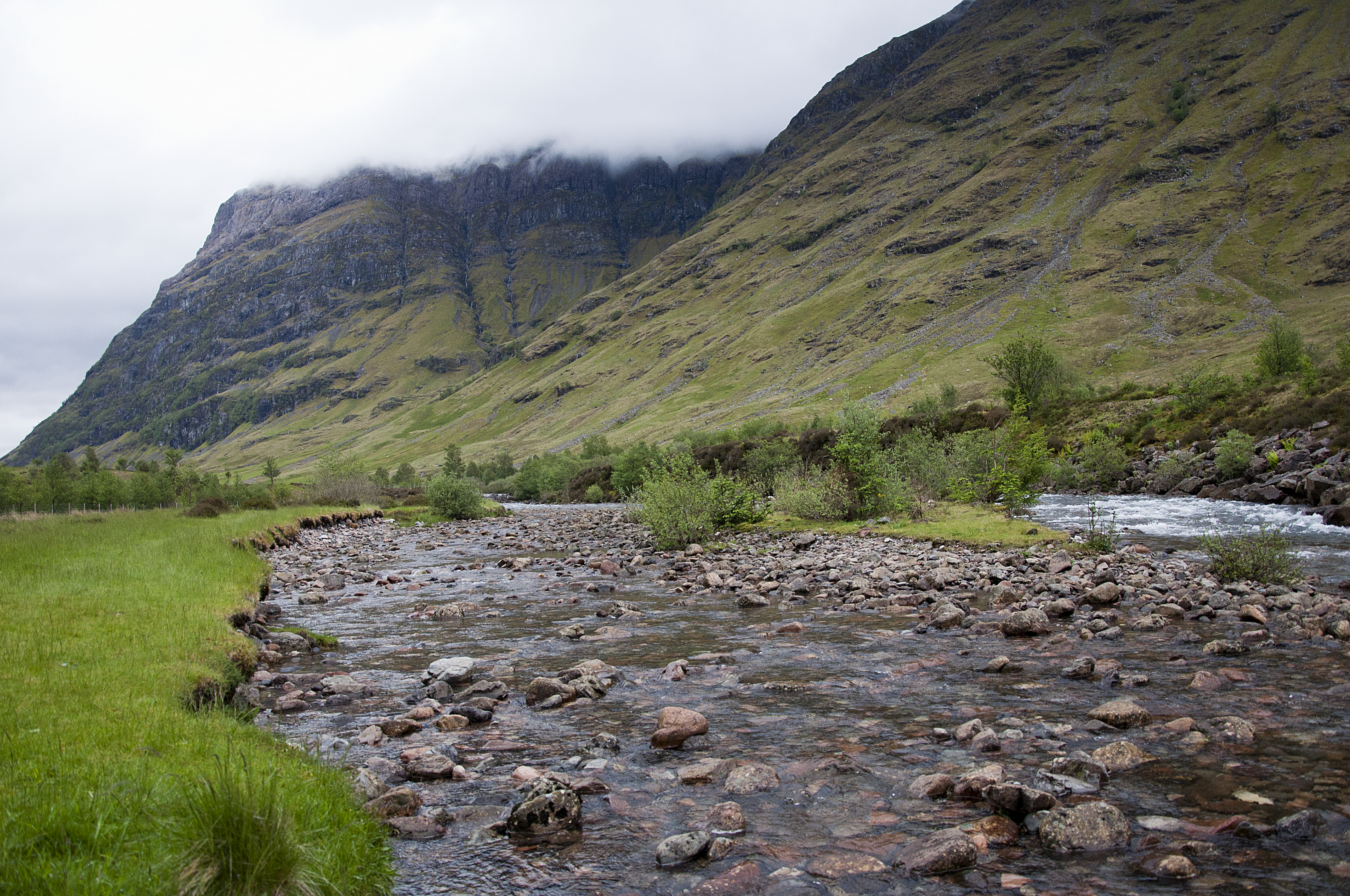
Gleann Leac na Muidhe, located in Argyllshire, Scotland, is a picturesque valley renowned for its stunning beauty and rich history. Nestled amidst the rugged mountains of the Scottish Highlands, the valley stretches for several miles, offering breathtaking views of lush greenery, cascading waterfalls, and meandering rivers.

The valley is home to a diverse range of flora and fauna, with its fertile soil supporting a variety of plant species. Ancient Caledonian pine forests can be found here, providing habitat for a wide array of wildlife, including red deer, golden eagles, and otters. The valley is also known for its abundance of wildflowers, which carpet the meadows and add a vibrant splash of color to the landscape.

Gleann Leac na Muidhe is steeped in history, with evidence of human settlement dating back thousands of years. Archaeological sites, such as standing stones and burial cairns, can be found scattered throughout the valley, offering a glimpse into the lives of the ancient inhabitants. The valley also played a significant role during the Jacobite uprising of 1745, with remnants of military fortifications still visible today.

For outdoor enthusiasts, Gleann Leac na Muidhe offers a plethora of activities. Hiking and mountain biking trails crisscross the valley, providing opportunities to explore its natural wonders. Fishing enthusiasts can cast their lines in the rivers and lochs, while photographers and nature lovers can indulge in capturing the beauty of the valley's landscapes at every turn.

Overall, Gleann Leac na Muidhe is a captivating destination that combines stunning natural beauty with a rich historical heritage, making it a must-visit location for anyone seeking an authentic Scottish experience.

If you have any feedback on the listing, please let us know in the comments section below.

Gleann Leac na Muidhe Images

Images are sourced within 2km of 56.64886/-5.0809629 or Grid Reference NN1155. Thanks to Geograph Open Source API. All images are credited.

Cairn on Meall Mòr The cairn marks the direction of an easy way off Meall Mòr which is a very steep hill. It is quite an old cairn, probably erected by shepherds. The level ridge runs past the snow patch to the summit, perched on the edge of the Glen Coe cauldron subsidence.
Cairn on Meall Mòr
The cairn marks the direction of an easy way off Meall Mòr which is a very steep hill. It is quite an old cairn, probably erected by shepherds. The level ridge runs past the snow patch to the summit, perched on the edge of the Glen Coe cauldron subsidence.
Bog on Meall Mòr The frozen bog was occupied by golden plovers.
Bog on Meall Mòr
The frozen bog was occupied by golden plovers.
Moorland north of Meall Ligiche Rock slabs on the lower slopes of the hill.  Looking over plantations towards Beinn a' Bheithir.
Moorland north of Meall Ligiche
Rock slabs on the lower slopes of the hill. Looking over plantations towards Beinn a' Bheithir.
View from lower slopes of Meall Ligiche Looking down through Gleann Leac na Muidhe towards Glencoe.
View from lower slopes of Meall Ligiche
Looking down through Gleann Leac na Muidhe towards Glencoe.
Sheep fencing south of Meall a'Bhuighe
Signal Rock, Glencoe Signal Rock caps the minor eminence of Tom a'Ghrianain ("Hill of the Sun").  According to tradition, the MacDonalds of Glencoe gathered here in times of crisis, and some assert that a fire was lit here to signal the start of the Massacre on 13 February 1692.  However, there is no evidence to support this.
Signal Rock, Glencoe
Signal Rock caps the minor eminence of Tom a'Ghrianain ("Hill of the Sun"). According to tradition, the MacDonalds of Glencoe gathered here in times of crisis, and some assert that a fire was lit here to signal the start of the Massacre on 13 February 1692. However, there is no evidence to support this.
Setting sun adds drama to the Glencoe tops The east ridge of Sgorr Dhearg in snow with Sgorr a' Choise painting its shadow on Meall Mòr and Bidean nam Bian beyond.
Setting sun adds drama to the Glencoe tops
The east ridge of Sgorr Dhearg in snow with Sgorr a' Choise painting its shadow on Meall Mòr and Bidean nam Bian beyond.
Glean-leac-na-muidhe The classic house block.  No problems with the road when this was taken, but now there is a bypass path around what I remember was once a working farm. I might try stopping up the road past my house - sorry no. 26 bus.
Glean-leac-na-muidhe
The classic house block. No problems with the road when this was taken, but now there is a bypass path around what I remember was once a working farm. I might try stopping up the road past my house - sorry no. 26 bus.
Meall Mor Looking towards Ben Nevis from Meall Mor.
Meall Mor
Looking towards Ben Nevis from Meall Mor.
Open gate, Glean-leac-na-muidhe Approaching the farm buildings in Glean-leac-na-muidhe ('glen of the slab of the milk churn') with Glen Coe's Aonach Eagach ridge in the distance, and An t-Sron ('the nose') - a spur of Bidean nam Bian - dominating the right-hand side of the view.
Open gate, Glean-leac-na-muidhe
Approaching the farm buildings in Glean-leac-na-muidhe ('glen of the slab of the milk churn') with Glen Coe's Aonach Eagach ridge in the distance, and An t-Sron ('the nose') - a spur of Bidean nam Bian - dominating the right-hand side of the view.
Allt na Muidhe ('stream of the milk churn') A view towards Sgurr na h-Ulaidh at the head of the glen.
Allt na Muidhe ('stream of the milk churn')
A view towards Sgurr na h-Ulaidh at the head of the glen.
Track in Glean-leac-na-muidhe Approaching the farm buildings in Glean-leac-na-muidhe ('glen of the slab of the milk churn') with Glen Coe's Aonach Eagach ridge in the distance, and An t-Sron ('the nose') - a spur of Bidean nam Bian - dominating the right-hand side of the view.
Track in Glean-leac-na-muidhe
Approaching the farm buildings in Glean-leac-na-muidhe ('glen of the slab of the milk churn') with Glen Coe's Aonach Eagach ridge in the distance, and An t-Sron ('the nose') - a spur of Bidean nam Bian - dominating the right-hand side of the view.
Farm buildings in Glean-leac-na-muidhe The name of this glen, meaning 'glen of the slab of the milk churn' in Gaelic, suggests a long history of agriculture.
Farm buildings in Glean-leac-na-muidhe
The name of this glen, meaning 'glen of the slab of the milk churn' in Gaelic, suggests a long history of agriculture.
Aonach Eagach from Glean-leac-na-muidhe Looking directly towards the Clachaig Gully, with its infamously dangerous steep path alongside.
Aonach Eagach from Glean-leac-na-muidhe
Looking directly towards the Clachaig Gully, with its infamously dangerous steep path alongside.
End of the track, Glean-leac-na-muidhe The vehicle track from the A82 ends here, but a well-worn path continues along the east bank of the Allt na Muidhe, used by Munro-baggers heading to Sgurr na h-Ulaidh.
End of the track, Glean-leac-na-muidhe
The vehicle track from the A82 ends here, but a well-worn path continues along the east bank of the Allt na Muidhe, used by Munro-baggers heading to Sgurr na h-Ulaidh.
A82 approaching Glen Coe from the north The A82 runs from Glasgow to Fort William and Inverness, passing along the shores of Loch Lomond and Loch Ness and in the shadow of Ben Nevis along the way. The majority of the route is a trunk road and hence managed by Transport Scotland, who view the road as a vitally important link through the Scottish Highlands and beyond. 

At 167 miles, the road is the second longest A-road in Scotland (after the A9) and along its route uses pieces of road first built in the 1750s.
A82 approaching Glen Coe from the north
The A82 runs from Glasgow to Fort William and Inverness, passing along the shores of Loch Lomond and Loch Ness and in the shadow of Ben Nevis along the way. The majority of the route is a trunk road and hence managed by Transport Scotland, who view the road as a vitally important link through the Scottish Highlands and beyond. At 167 miles, the road is the second longest A-road in Scotland (after the A9) and along its route uses pieces of road first built in the 1750s.
Aonach Dubh a' Ghlinne Sgùrr na h-Ulaidh on the right.
Aonach Dubh a' Ghlinne
Sgùrr na h-Ulaidh on the right.
Show me another place!

Gleann Leac na Muidhe is located at Grid Ref: NN1155 (Lat: 56.64886, Lng: -5.0809629)

Unitary Authority: Highland

Police Authority: Highlands and Islands

What 3 Words

///whiplash.protests.relatives. Near Glencoe, Highland

Nearby Locations

Gleann Leac na Muidhe

Related Wikis

Meall Mor (Glen Coe)

Meall Mor (676 m) is a mountain in the Grampian Mountains of Scotland. It lies above the Glencoe village at the foot of Glen Coe in Lochaber, Scotland...

Clachaig Inn

The Clachaig Inn is a hotel and pub in Glen Coe, Lochaber, Highland, Scotland. It is popular with walkers and climbers who come to visit the surrounding...

Bidean nam Bian

Bidean nam Bian (Scottish Gaelic: Bidean nam Beann, 'peak of the mountains') is the highest peak in a group of mountains south of Glen Coe and north of...

Loch Achtriochtan

Loch Achtriochtan or Loch Trychardan is a small shallow freshwater loch located to the east of Glencoe village in Lochaber in the Scottish Highlands. It...

Sgùrr na h-Ulaidh

Sgùrr na h-Ulaidh (also Sgòr na h-Ulaidh) ("Peak of the Treasure") is a mountain lying to the south of the village of Glencoe in the Scottish Highlands...

Henderson Stone

The Henderson Stone (Clach Eanruig in Scottish Gaelic) is a granite boulder in a field in the Glencoe (Carnoch) area of Scotland. Clach Eanruig is translated...

Massacre of Glencoe Monument

The Massacre of Glencoe Monument is a memorial to the Massacre of Glencoe (Scottish Gaelic: Mort Ghlinne Comhann), which took place in Glen Coe in the...

River Coe

The River Coe (Scottish Gaelic: Comhan) rises at the north-eastern base of Buachaille Etive Beag in Scotland and flows west along Glen Coe. After dramatic...

Nearby Amenities

Located within 500m of 56.64886,-5.0809629
Gleann Leac na Muidhe
Place: isolated_dwelling
Lat/Long: 56.650534/-5.0779832
Power: pole
Lat/Long: 56.6507116/-5.0782621
Power: pole
Lat/Long: 56.650971/-5.0790707
Power: pole
Lat/Long: 56.6514628/-5.0787213
Power: pole
Lat/Long: 56.6519446/-5.0778468
Power: pole
Lat/Long: 56.6522895/-5.0772175
Ford: yes
Lat/Long: 56.6517788/-5.0761224
Ford: yes
Lat/Long: 56.6506295/-5.0763416
The data included in this document is from www.openstreetmap.org. The data is made available under ODbL.

Have you been to Gleann Leac na Muidhe?

Leave your review of Gleann Leac na Muidhe below (or comments, questions and feedback).