Lackenby

Settlement in Yorkshire

England

Lackenby

Reservoir west of Lazenby
Reservoir west of Lazenby Credit: Eirian Evans

Lackenby is a small village located in the borough of Redcar and Cleveland, within the county of Yorkshire, England. Situated approximately 4 miles southeast of Middlesbrough, Lackenby is nestled in a rural setting, surrounded by picturesque countryside and farmland.

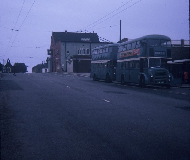
The village is primarily known for its industrial heritage, with the British Steel plant being a prominent feature of the area. The steelworks at Lackenby were first established in the early 20th century and have played a vital role in the local economy ever since. The industry has shaped the village's identity and provided employment opportunities for generations of residents.

Despite its industrial ties, Lackenby maintains a strong sense of community with a range of amenities available to its residents. These include a local primary school, a community center, and a few small shops serving everyday needs. The village is also home to a number of quaint cottages and residential areas, giving it a charming and peaceful atmosphere.

Lackenby benefits from its proximity to the nearby town of Middlesbrough, which offers a wider range of services, entertainment options, and shopping centers. Additionally, the village enjoys good transport links, with easy access to major roads and public transportation, making it convenient for commuting to neighboring towns or exploring the surrounding Yorkshire countryside.

Overall, Lackenby offers a unique blend of industrial heritage, rural charm, and community spirit, making it an appealing place to live for those seeking a quieter, close-knit community while still having access to urban amenities.

If you have any feedback on the listing, please let us know in the comments section below.

Lackenby Images

Images are sourced within 2km of 54.566231/-1.126118 or Grid Reference NZ5619. Thanks to Geograph Open Source API. All images are credited.

Reservoir west of Lazenby
Looking towards Eston Moor Beacon
Carr Pond on Eston Moor (1)
Carr Pond on Eston Moor (2)
Path leading to the top of Eston Moor
Distant view of Rosebery Topping from Eston Moor
Roseberry Topping from Eston Moor Beacon
Path leading to Eston Moor Beacon
Eston Moor ridge view
Eston Moor view south west
Middlesbrough from Eston Moor
The Eston Hotel, Eston A Sam Smith's public house.
The Eston Hotel, Eston
A Sam Smith's public house.
The Eston Hotel, Eston A Sam Smith's public house.
The Eston Hotel, Eston
A Sam Smith's public house.
The Eston Hotel, Eston A Sam Smith's public house.
The Eston Hotel, Eston
A Sam Smith's public house.
Eston Nab Beacon tower which was erected by Thomas Jackson of Lackenby about 1800 as a look-out post against invasion during the Napoleonic wars and which again served the same purpose in the second world war of 1939-1945. It stands within a Bronze Age fortified camp. The beacon was used as a house and survived until 1956. It was then demolished.
Eston Nab
Beacon tower which was erected by Thomas Jackson of Lackenby about 1800 as a look-out post against invasion during the Napoleonic wars and which again served the same purpose in the second world war of 1939-1945. It stands within a Bronze Age fortified camp. The beacon was used as a house and survived until 1956. It was then demolished.
Site of former Eston station View roughly SW: ex-NER terminus of a short branch from Flats Lane near Cargo Fleet, which had a passenger service only until 11/3/29, but was a goods terminal until 3/10/66. There was no sign of railway property in 1997.
Site of former Eston station
View roughly SW: ex-NER terminus of a short branch from Flats Lane near Cargo Fleet, which had a passenger service only until 11/3/29, but was a goods terminal until 3/10/66. There was no sign of railway property in 1997.
Two Buses in High Street, Eston Taken in July 1970, this photo shows two vehicles in the short lived livery of Teesside Municipal Transport, which existed from the 1st April 1968 to 31st March 1974. Previously, they were owned by the Tees-side Railless Traction Board and painted in the Board's dark green and cream livery. The front vehicle is 37 (FVN 37D) a Leyland Titan motorbus with Roe 61-seater bodywork working to North Ormesby via Grangetown, whilst the one behind it is a Sunbeam F4 trolleybus 4 (GAJ 14) with similar bodywork working on a private tour of the area's trolleybus system which closed nine months later in April 1971. The trolleybus overhead wiring seen in this photo was soon dismantled after that closure. Behind the two vehicles in High Street is the Eston Constitutional WMC with the clock fixed to it, whilst in the distance to the left of the photo is Eston Congregational Church.
Two Buses in High Street, Eston
Taken in July 1970, this photo shows two vehicles in the short lived livery of Teesside Municipal Transport, which existed from the 1st April 1968 to 31st March 1974. Previously, they were owned by the Tees-side Railless Traction Board and painted in the Board's dark green and cream livery. The front vehicle is 37 (FVN 37D) a Leyland Titan motorbus with Roe 61-seater bodywork working to North Ormesby via Grangetown, whilst the one behind it is a Sunbeam F4 trolleybus 4 (GAJ 14) with similar bodywork working on a private tour of the area's trolleybus system which closed nine months later in April 1971. The trolleybus overhead wiring seen in this photo was soon dismantled after that closure. Behind the two vehicles in High Street is the Eston Constitutional WMC with the clock fixed to it, whilst in the distance to the left of the photo is Eston Congregational Church.
Woodland beside Wilton Lane
Show me another place!

Lackenby is located at Grid Ref: NZ5619 (Lat: 54.566231, Lng: -1.126118)

Division: North Riding

Unitary Authority: Redcar and Cleveland

Police Authority: Cleveland

What 3 Words

///vast.first.drank. Near South Bank, North Yorkshire

Nearby Locations

Whale Hill Lackenby

Related Wikis

Lackenby

Lackenby is a small village in Redcar and Cleveland, North Yorkshire, England. It is situated to the immediate east of Eston and Middlesbrough and immediately...

Lazenby

Lazenby is a village in the unitary authority of Redcar and Cleveland and the ceremonial county of North Yorkshire, England. It is located just off the...

Whale Hill

Whale Hill is an area of Eston in Redcar and Cleveland of North Yorkshire, England, lying at the foot of the Eston Hills. It is within Teesside built-up...

Whitetail Clean Energy

The Whitetail Clean Energy is a proposed power station in Wilton, Redcar and Cleveland, England. The generating process of the plant is listed as a "clean...

Nearby Amenities

Located within 500m of 54.566231,-1.126118
Traffic Signals
Traffic Signals: signal
Lat/Long: 54.5654053/-1.123078
Traffic Signals
Traffic Signals: signal
Lat/Long: 54.5654643/-1.1228808
Traffic Signals
Traffic Signals: signal
Lat/Long: 54.5659214/-1.1218534
Power: tower
Source: Bing
Lat/Long: 54.5698782/-1.1299849
Power: tower
Source: Bing
Lat/Long: 54.5680857/-1.1312898
Power: portal
Lat/Long: 54.5677569/-1.1316423
Power: tower
Source: Bing
Tower Type: termination
Lat/Long: 54.5680212/-1.1305188
Power: tower
Source: Bing
Lat/Long: 54.5667789/-1.1301855
Design: three-level
Power: tower
Source: Bing
Structure: lattice
Tower Type: anchor
Lat/Long: 54.569195/-1.1256001
Power: tower
Source: Bing
Lat/Long: 54.5634296/-1.1271157
Power: tower
Source: Bing
Lat/Long: 54.5632211/-1.1283114
Source: Bing
Lat/Long: 54.5622544/-1.1282447
Power: tower
Source: Bing
Lat/Long: 54.5619858/-1.1257354
Crossing
Crossing Island: yes
Lat/Long: 54.5633846/-1.1321247
Power: tower
Source: Bing
Lat/Long: 54.565428/-1.129726
Power: portal
Lat/Long: 54.5658109/-1.130188
Power: portal
Lat/Long: 54.5659348/-1.1299744
Power: tower
Lat/Long: 54.5656307/-1.131018
Power: transformer
Source: Bing
Lat/Long: 54.5657779/-1.1309752
Power: portal
Lat/Long: 54.5678265/-1.130829
Location Transition: yes
Lat/Long: 54.5678465/-1.1314797
Power: pole
Source: survey; Bing
Lat/Long: 54.5629824/-1.1238994
Power: pole
Source: survey; Bing
Lat/Long: 54.563557/-1.1226011
Power: pole
Source: survey; Bing
Lat/Long: 54.56411/-1.1213514
Power: pole
Source: survey; Bing
Lat/Long: 54.5644896/-1.1204937
Power: pole
Source: survey; Bing
Lat/Long: 54.5650748/-1.1191713
Source: Bing
Lat/Long: 54.5658345/-1.1304303
Frequency: 50
Location: outdoor
Power: transformer
Transformer: main
Voltage Primary: 400000
Lat/Long: 54.5662346/-1.1306836
Frequency: 50
Location: outdoor
Power: transformer
Transformer: main
Voltage Primary: 400000
Lat/Long: 54.5663913/-1.1303886
Traffic Signals
Traffic Signals: signal
Lat/Long: 54.5659487/-1.1215707
Rest Area
Lat/Long: 54.5670343/-1.1186302
Lackenby
Place: hamlet
Wikidata: Q281491
Wikipedia: en:Lackenby
Lat/Long: 54.5667684/-1.1285546
South Lackenby
Place: hamlet
Lat/Long: 54.564716/-1.1280721
Location Transition: yes
Lat/Long: 54.5677266/-1.1306879
Power: transformer
Lat/Long: 54.5667236/-1.1336491
Power: transformer
Lat/Long: 54.5676177/-1.1319351
Power: transformer
Lat/Long: 54.5672228/-1.1327022
Power: portal
Lat/Long: 54.5664981/-1.1301756
The data included in this document is from www.openstreetmap.org. The data is made available under ODbL.

Have you been to Lackenby?

Leave your review of Lackenby below (or comments, questions and feedback).