Gortan an t-Sailleir
Valley in Argyllshire
Scotland
Gortan an t-Sailleir
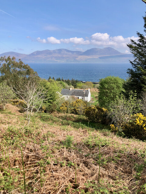
Gortan an t-Sailleir is a picturesque valley located in Argyllshire, Scotland. Nestled amidst the stunning landscape of the Scottish Highlands, it is renowned for its natural beauty and serene atmosphere. The valley is surrounded by rolling hills and towering mountains, creating a breathtaking backdrop for visitors.
With its lush greenery and abundance of wildlife, Gortan an t-Sailleir is a haven for nature enthusiasts. The valley is home to a diverse range of plant and animal species, including rare birds, deer, and wildflowers. Hikers and nature lovers can explore the numerous walking trails that wind through the valley, offering unparalleled views of the surrounding landscape.
In addition to its natural wonders, Gortan an t-Sailleir is also rich in history and culture. The valley is dotted with ancient ruins, including stone circles and burial mounds, which provide a glimpse into the area's past. Visitors can immerse themselves in the local heritage by visiting nearby historic sites and engaging with the friendly locals, who are known for their warm hospitality.
Gortan an t-Sailleir offers a tranquil escape from the hustle and bustle of everyday life, making it a popular destination for those seeking peace and relaxation. Whether it be exploring the valley's natural wonders, delving into its rich history, or simply enjoying the stunning views, Gortan an t-Sailleir offers a truly unforgettable experience for visitors of all ages.
If you have any feedback on the listing, please let us know in the comments section below.
Gortan an t-Sailleir Images
Images are sourced within 2km of 55.668912/-5.4715523 or Grid Reference NR8147. Thanks to Geograph Open Source API. All images are credited.


![Allt na Buaile Salaich A single unroofed building is depicted on the 1st edition of the OS 6-inch 1870, reference Maps.nls.uk. (2022). View map: OS six-inch to the mile, 1st ed., Argyllshire, Sheet CCXXIV - Ordnance Survey Six-inch 1st edition, Scotland, 1843-1882. [online] Available at: <span class="nowrap"><a title="https://maps.nls.uk/view/228776380#zoom=6&amp;lat=478&amp;lon=12149&amp;layers=BT" rel="nofollow ugc noopener" href="https://maps.nls.uk/view/228776380#zoom=6&amp;lat=478&amp;lon=12149&amp;layers=BT">Link</a><img style="margin-left:2px;" alt="External link" title="External link - shift click to open in new window" src="https://s1.geograph.org.uk/img/external.png" width="10" height="10"/></span> [Accessed 26 May 2022].
Reference: Canmore.org.uk. (2022). Allt Na Buaile Salaich | Canmore. [online] Available at: <span class="nowrap"><a title="https://canmore.org.uk/site/154367/allt-na-buaile-salaich" rel="nofollow ugc noopener" href="https://canmore.org.uk/site/154367/allt-na-buaile-salaich">Link</a><img style="margin-left:2px;" alt="External link" title="External link - shift click to open in new window" src="https://s1.geograph.org.uk/img/external.png" width="10" height="10"/></span> [Accessed 26 May 2022] — although the quoted map reference is a little off.](https://s2.geograph.org.uk/geophotos/07/18/30/7183022_463147ea.jpg)


Gortan an t-Sailleir is located at Grid Ref: NR8147 (Lat: 55.668912, Lng: -5.4715523)
Unitary Authority: Argyll and Bute
Police Authority: Argyll and West Dunbartonshire
What 3 Words
///streaking.troubled.storeroom. Near Lochranza, North Ayrshire
Nearby Locations
Related Wikis
Grogport
Grogport (Scottish Gaelic: Gròb-phort) is a hamlet in Argyll and Bute, Scotland. It lies on the coast of Kintyre, on the Kilbrannan Sound, across from...

Pirnmill
Pirnmill (Scottish Gaelic: Muileann nam Piùirneachan) is a small village on the north-west coast of the Isle of Arran, Scotland. The village is situated...

Whitefarland
Whitefarland (Scottish Gaelic: An Aoirinn) is a clachan on the Isle of Arran in the Firth of Clyde, Scotland. It is located approximately 1 mile (2 kilometres...

Kilbrannan Sound
Kilbrannan Sound (Scottish Gaelic: An Caolas Branndanach) is a marine water body that separates the Kintyre Peninsula of Scotland from the island of Arran...

Torr Mor
Torr Mor is a hill peak landform on the coastal east side of the Kintyre Peninsula in Scotland. The peak offers views over the Kilbrannan Sound. The Forestry...

Carradale
Carradale (Scottish Gaelic: Càradal, pronounced [ˈkʰaːrˠət̪əl̪ˠ]) is a village on the east side of Kintyre, overlooking the Kilbrannan Sound and the west...

Airds Castle
Airds Castle is a ruined medieval castle near Carradale, Kintyre, Argyll and Bute, Scotland. The castle held a position on the summit of a rocky headland...

Catacol Bay
Catacol Bay (Scottish Gaelic: Catagal bhàigh) is a small shallow-curved tidal, 310° facing, rocky coastal embayment located on the northwest tip of the...
Nearby Amenities
Located within 500m of 55.668912,-5.4715523Have you been to Gortan an t-Sailleir?
Leave your review of Gortan an t-Sailleir below (or comments, questions and feedback).