Barnsbury

Settlement in Middlesex

England

Barnsbury

Holloway : food bar shutters Located not far from the Emirates Stadium, the home of Arsenal Football Club
Holloway : food bar shutters Credit: Jim Osley

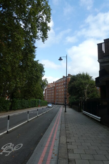
Barnsbury is a small residential area located in the historic county of Middlesex, England. Situated just north of central London, it is part of the Islington borough and falls within the N1 postal district. The area is known for its picturesque streets, charming Victorian terraced houses, and leafy green spaces.

Barnsbury has a rich history that dates back to the medieval period when it was a rural area outside of London. Over the years, it gradually transformed into a suburban enclave, attracting affluent residents. Today, it is a sought-after residential neighborhood, popular among families and professionals seeking a quiet and well-connected place to live.

One of the defining features of Barnsbury is its architectural heritage. The area showcases a mix of Georgian and Victorian buildings, which have been carefully preserved and restored. This blend of architectural styles gives Barnsbury a unique character and adds to its aesthetic appeal.

In addition to its beautiful homes, Barnsbury boasts several green spaces, providing residents with ample opportunities for outdoor activities. Barnsbury Wood, a small nature reserve, is a hidden gem within the area, offering a peaceful retreat from the hustle and bustle of city life.

Despite its tranquil atmosphere, Barnsbury benefits from its proximity to central London. The neighborhood is well-served by public transportation, with several underground and overground stations nearby, allowing for easy access to the rest of the city.

Overall, Barnsbury is a charming and well-preserved residential area that combines history, natural beauty, and convenient location, making it an idyllic place to call home.

If you have any feedback on the listing, please let us know in the comments section below.

Barnsbury Images

Images are sourced within 2km of 51.544262/-0.119469 or Grid Reference TQ3084. Thanks to Geograph Open Source API. All images are credited.

Holloway : food bar shutters Located not far from the Emirates Stadium, the home of Arsenal Football Club
Holloway : food bar shutters
Located not far from the Emirates Stadium, the home of Arsenal Football Club
Eversholt Street Looking along Eversholt Street towards the junction with Oakley Square.
Eversholt Street
Looking along Eversholt Street towards the junction with Oakley Square.
Cycle lane in Oakley Square Looking along Oakley Square beside the Mayford Estate.
Cycle lane in Oakley Square
Looking along Oakley Square beside the Mayford Estate.
Goldington Crescent Gardens Small park beside Pancras Road.
Goldington Crescent Gardens
Small park beside Pancras Road.
Camley Street Looking along Camley Street beside the railway bridge over the road.
Camley Street
Looking along Camley Street beside the railway bridge over the road.
Somers Town Footbridge Bridge over the canal leading into Coal Drops Yard.
Somers Town Footbridge
Bridge over the canal leading into Coal Drops Yard.
Camley Street Natural Park Looking at works going on at Camley Street Natural Park from Somers Town Bridge.
Camley Street Natural Park
Looking at works going on at Camley Street Natural Park from Somers Town Bridge.
St. Pancras Lock Looking towards St. Pancras Lock from Somers Town Bridge over Regent's Canal.
St. Pancras Lock
Looking towards St. Pancras Lock from Somers Town Bridge over Regent's Canal.
Ivo Place Holloway London The old shopfront now displays an "Age of Stupid" sign. A sign of the times?
Ivo Place Holloway London
The old shopfront now displays an "Age of Stupid" sign. A sign of the times?
The Black Cats outside the Black Cat Factory The former Carreras Cigarette Factory in Mornington Crescent near Camden Town is sometimes called simply the ‘Black Cat Factory’. The Carreras Tobacco Company began in 19th century London. Don José Joaquin Carreras Ferrer had a shop at 61 Prince’s Street near Leicester Square. He had a black cat which, on sunny days, sat in the window of his shop. Londoners wishing to buy tobacco used to ask cab drivers to take them to the tobacconist's shop in Wardour Street with the black cat in the window, because the name Carreras was difficult to pronounce. Thus the Black Cat name became famous. In 1886 it was used as a trademark by Carrera.

In 1928, having outgrown previous sites, the Arcadia Works opened in Mornington Crescent. The extraordinary design was fuelled by the discovery of Tutankhamun’s tomb in 1922.The discovery prompted a wave of Egypt-mania in fashion, architecture and design. The combination of the Egyptian theme and the Black Cat, led to the Egyptian Cat Goddess, Bast, and helped decide the system of decoration. Local people still call the building the Black Cat Factory.
The Black Cats outside the Black Cat Factory
The former Carreras Cigarette Factory in Mornington Crescent near Camden Town is sometimes called simply the ‘Black Cat Factory’. The Carreras Tobacco Company began in 19th century London. Don José Joaquin Carreras Ferrer had a shop at 61 Prince’s Street near Leicester Square. He had a black cat which, on sunny days, sat in the window of his shop. Londoners wishing to buy tobacco used to ask cab drivers to take them to the tobacconist's shop in Wardour Street with the black cat in the window, because the name Carreras was difficult to pronounce. Thus the Black Cat name became famous. In 1886 it was used as a trademark by Carrera. In 1928, having outgrown previous sites, the Arcadia Works opened in Mornington Crescent. The extraordinary design was fuelled by the discovery of Tutankhamun’s tomb in 1922.The discovery prompted a wave of Egypt-mania in fashion, architecture and design. The combination of the Egyptian theme and the Black Cat, led to the Egyptian Cat Goddess, Bast, and helped decide the system of decoration. Local people still call the building the Black Cat Factory.
The Black Cats outside the Black Cat Factory The former Carreras Cigarette Factory in Mornington Crescent near Camden Town is sometimes called simply the ‘Black Cat Factory’. The Carreras Tobacco Company began in 19th century London. Don José Joaquin Carreras Ferrer had a shop at 61 Prince’s Street near Leicester Square. He had a black cat which, on sunny days, sat in the window of his shop. Londoners wishing to buy tobacco used to ask cab drivers to take them to the tobacconist's shop in Wardour Street with the black cat in the window, because the name Carreras was difficult to pronounce. Thus the Black Cat name became famous. In 1886 it was used as a trademark by Carrera.

In 1928, having outgrown previous sites, the Arcadia Works opened in Mornington Crescent. The extraordinary design was fuelled by the discovery of Tutankhamun’s tomb in 1922.The discovery prompted a wave of Egypt-mania in fashion, architecture and design. The combination of the Egyptian theme and the Black Cat, led to the Egyptian Cat Goddess, Bast, and helped decide the system of decoration. Local people still call the building the Black Cat Factory. See also <span class="nowrap"><a title="https://lookup.london/carreras-cigarette-factory/" rel="nofollow ugc noopener" href="https://lookup.london/carreras-cigarette-factory/">Link</a><img style="margin-left:2px;" alt="External link" title="External link - shift click to open in new window" src="https://s1.geograph.org.uk/img/external.png" width="10" height="10"/></span>
The Black Cats outside the Black Cat Factory
The former Carreras Cigarette Factory in Mornington Crescent near Camden Town is sometimes called simply the ‘Black Cat Factory’. The Carreras Tobacco Company began in 19th century London. Don José Joaquin Carreras Ferrer had a shop at 61 Prince’s Street near Leicester Square. He had a black cat which, on sunny days, sat in the window of his shop. Londoners wishing to buy tobacco used to ask cab drivers to take them to the tobacconist's shop in Wardour Street with the black cat in the window, because the name Carreras was difficult to pronounce. Thus the Black Cat name became famous. In 1886 it was used as a trademark by Carrera. In 1928, having outgrown previous sites, the Arcadia Works opened in Mornington Crescent. The extraordinary design was fuelled by the discovery of Tutankhamun’s tomb in 1922.The discovery prompted a wave of Egypt-mania in fashion, architecture and design. The combination of the Egyptian theme and the Black Cat, led to the Egyptian Cat Goddess, Bast, and helped decide the system of decoration. Local people still call the building the Black Cat Factory. See also LinkExternal link
The Black Cat Factory seen across Hampstead Road The former Carreras Cigarette Factory in Mornington Crescent near Camden Town is sometimes called simply the ‘Black Cat Factory’. The Carreras Tobacco Company began in 19th century London. Don José Joaquin Carreras Ferrer had a shop at 61 Prince’s Street near Leicester Square. He had a black cat which, on sunny days, sat in the window of his shop. Londoners wishing to buy tobacco used to ask cab drivers to take them to the tobacconist's shop in Wardour Street with the black cat in the window, because the name Carreras was difficult to pronounce. Thus the Black Cat name became famous. In 1886 it was used as a trademark by Carrera.

In 1928, having outgrown previous sites, the Arcadia Works opened in Mornington Crescent. The extraordinary design was fuelled by the discovery of Tutankhamun’s tomb in 1922.The discovery prompted a wave of Egypt-mania in fashion, architecture and design. The combination of the Egyptian theme and the Black Cat, led to the Egyptian Cat Goddess, Bast, and helped decide the system of decoration. Local people still call the building the Black Cat Factory. See also <span class="nowrap"><a title="https://lookup.london/carreras-cigarette-factory/" rel="nofollow ugc noopener" href="https://lookup.london/carreras-cigarette-factory/">Link</a><img style="margin-left:2px;" alt="External link" title="External link - shift click to open in new window" src="https://s1.geograph.org.uk/img/external.png" width="10" height="10"/></span>
The Black Cat Factory seen across Hampstead Road
The former Carreras Cigarette Factory in Mornington Crescent near Camden Town is sometimes called simply the ‘Black Cat Factory’. The Carreras Tobacco Company began in 19th century London. Don José Joaquin Carreras Ferrer had a shop at 61 Prince’s Street near Leicester Square. He had a black cat which, on sunny days, sat in the window of his shop. Londoners wishing to buy tobacco used to ask cab drivers to take them to the tobacconist's shop in Wardour Street with the black cat in the window, because the name Carreras was difficult to pronounce. Thus the Black Cat name became famous. In 1886 it was used as a trademark by Carrera. In 1928, having outgrown previous sites, the Arcadia Works opened in Mornington Crescent. The extraordinary design was fuelled by the discovery of Tutankhamun’s tomb in 1922.The discovery prompted a wave of Egypt-mania in fashion, architecture and design. The combination of the Egyptian theme and the Black Cat, led to the Egyptian Cat Goddess, Bast, and helped decide the system of decoration. Local people still call the building the Black Cat Factory. See also LinkExternal link
The Black Cat Factory, Mornington Crescent The former Carreras Cigarette Factory in Mornington Crescent near Camden Town is sometimes called simply the ‘Black Cat Factory’. The Carreras Tobacco Company began in 19th century London. Don José Joaquin Carreras Ferrer had a shop at 61 Prince’s Street near Leicester Square. He had a black cat which, on sunny days, sat in the window of his shop. Londoners wishing to buy tobacco used to ask cab drivers to take them to the tobacconist's shop in Wardour Street with the black cat in the window, because the name Carreras was difficult to pronounce. Thus the Black Cat name became famous. In 1886 it was used as a trademark by Carrera.

In 1928, having outgrown previous sites, the Arcadia Works opened in Mornington Crescent. The extraordinary design was fuelled by the discovery of Tutankhamun’s tomb in 1922.The discovery prompted a wave of Egypt-mania in fashion, architecture and design. The combination of the Egyptian theme and the Black Cat, led to the Egyptian Cat Goddess, Bast, and helped decide the system of decoration. Local people still call the building the Black Cat Factory. See also <span class="nowrap"><a title="https://lookup.london/carreras-cigarette-factory/" rel="nofollow ugc noopener" href="https://lookup.london/carreras-cigarette-factory/">Link</a><img style="margin-left:2px;" alt="External link" title="External link - shift click to open in new window" src="https://s1.geograph.org.uk/img/external.png" width="10" height="10"/></span>
The Black Cat Factory, Mornington Crescent
The former Carreras Cigarette Factory in Mornington Crescent near Camden Town is sometimes called simply the ‘Black Cat Factory’. The Carreras Tobacco Company began in 19th century London. Don José Joaquin Carreras Ferrer had a shop at 61 Prince’s Street near Leicester Square. He had a black cat which, on sunny days, sat in the window of his shop. Londoners wishing to buy tobacco used to ask cab drivers to take them to the tobacconist's shop in Wardour Street with the black cat in the window, because the name Carreras was difficult to pronounce. Thus the Black Cat name became famous. In 1886 it was used as a trademark by Carrera. In 1928, having outgrown previous sites, the Arcadia Works opened in Mornington Crescent. The extraordinary design was fuelled by the discovery of Tutankhamun’s tomb in 1922.The discovery prompted a wave of Egypt-mania in fashion, architecture and design. The combination of the Egyptian theme and the Black Cat, led to the Egyptian Cat Goddess, Bast, and helped decide the system of decoration. Local people still call the building the Black Cat Factory. See also LinkExternal link
The Black Cat Factory seen across Hampstead Road The former Carreras Cigarette Factory in Mornington Crescent near Camden Town is sometimes called simply the ‘Black Cat Factory’. The Carreras Tobacco Company began in 19th century London. Don José Joaquin Carreras Ferrer had a shop at 61 Prince’s Street near Leicester Square. He had a black cat which, on sunny days, sat in the window of his shop. Londoners wishing to buy tobacco used to ask cab drivers to take them to the tobacconist's shop in Wardour Street with the black cat in the window, because the name Carreras was difficult to pronounce. Thus the Black Cat name became famous. In 1886 it was used as a trademark by Carrera.

In 1928, having outgrown previous sites, the Arcadia Works opened in Mornington Crescent. The extraordinary design was fuelled by the discovery of Tutankhamun’s tomb in 1922.The discovery prompted a wave of Egypt-mania in fashion, architecture and design. The combination of the Egyptian theme and the Black Cat, led to the Egyptian Cat Goddess, Bast, and helped decide the system of decoration. Local people still call the building the Black Cat Factory. See also <span class="nowrap"><a title="https://lookup.london/carreras-cigarette-factory/" rel="nofollow ugc noopener" href="https://lookup.london/carreras-cigarette-factory/">Link</a><img style="margin-left:2px;" alt="External link" title="External link - shift click to open in new window" src="https://s1.geograph.org.uk/img/external.png" width="10" height="10"/></span>
The Black Cat Factory seen across Hampstead Road
The former Carreras Cigarette Factory in Mornington Crescent near Camden Town is sometimes called simply the ‘Black Cat Factory’. The Carreras Tobacco Company began in 19th century London. Don José Joaquin Carreras Ferrer had a shop at 61 Prince’s Street near Leicester Square. He had a black cat which, on sunny days, sat in the window of his shop. Londoners wishing to buy tobacco used to ask cab drivers to take them to the tobacconist's shop in Wardour Street with the black cat in the window, because the name Carreras was difficult to pronounce. Thus the Black Cat name became famous. In 1886 it was used as a trademark by Carrera. In 1928, having outgrown previous sites, the Arcadia Works opened in Mornington Crescent. The extraordinary design was fuelled by the discovery of Tutankhamun’s tomb in 1922.The discovery prompted a wave of Egypt-mania in fashion, architecture and design. The combination of the Egyptian theme and the Black Cat, led to the Egyptian Cat Goddess, Bast, and helped decide the system of decoration. Local people still call the building the Black Cat Factory. See also LinkExternal link
Kentish Town Road, NW1 (southern portion) View south. The bridge in the distance carries the Overground's North London line.

Photo taken on an afternoon of intermittent fine drizzle.
Kentish Town Road, NW1 (southern portion)
View south. The bridge in the distance carries the Overground's North London line. Photo taken on an afternoon of intermittent fine drizzle.
Gloucester Crescent, London NW1 Preposterous palazzi.
Gloucester Crescent, London NW1
Preposterous palazzi.
Inverness Street, Camden Town, NW1 Looking towards Camden High Street from the corner of Arlington Road.
Inverness Street, Camden Town, NW1
Looking towards Camden High Street from the corner of Arlington Road.
Camden Street, London NW1
Show me another place!

Barnsbury is located at Grid Ref: TQ3084 (Lat: 51.544262, Lng: -0.119469)

Unitary Authority: Islington

Police Authority: Metropolitan

What 3 Words

///expose.spared.barks. Near Barnsbury, London

Nearby Locations

Barnsbury

Related Wikis

Cattle Market Ground

Cattle Market Ground was a cricket ground in Islington, London (formerly Middlesex). The first recorded match on the ground was in 1863, when Middlesex...

Caledonian Road, London

Caledonian Road passes for about a mile and a half north–south through the London Borough of Islington. It connects North London, from Camden Road near...
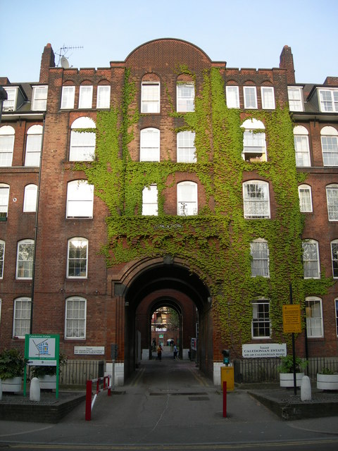
Caledonian Estate

The Caledonian Estate is a Grade II listed, early Edwardian estate towards the northern end of the Caledonian Road in Islington, London. It is situated...

HM Prison Pentonville

HM Prison Pentonville (informally "The Ville") is an English Category B men's prison, operated by His Majesty's Prison Service. Pentonville Prison is not...

Nearby Amenities

Located within 500m of 51.544262,-0.119469
Vale Royal
Bus: yes
Local Ref: P
Public Transport: stop_position
Lat/Long: 51.5418827/-0.1255191
Mini Roundabout
Direction: clockwise
Lat/Long: 51.543207/-0.1132609
Crossing
Crossing: uncontrolled
Crossing Island: yes
Crossing Markings: zebra
Crossing Ref: zebra
Proposed Crossing Ref: tiger
Surface: asphalt
Tactile Paving: yes
Lat/Long: 51.5451008/-0.1261051
Curve Geometry: yes
Lat/Long: 51.5413448/-0.1156945
Caledonian Road & Barnsbury
Public Transport: stop_position
Railway: stop
Ref: 2
Train: yes
Lat/Long: 51.5432606/-0.1159066
Ref GB Tflcid: RWG026422
Traffic Calming: hump
Lat/Long: 51.5485901/-0.1200994
Was Highway: mini_roundabout
Lat/Long: 51.5450605/-0.1263519
Railway: switch
Lat/Long: 51.5425814/-0.1223719
Created By: Merkaartor 0.12
Lat/Long: 51.5414127/-0.1154733
Created By: Merkaartor 0.12
Lat/Long: 51.5412329/-0.1158565
Created By: Merkaartor 0.12
Lat/Long: 51.5410789/-0.1145709
Ref GB Tflcid: RWG032636
Traffic Calming: table
Lat/Long: 51.5413387/-0.117699
Noexit: yes
Lat/Long: 51.5418352/-0.1176948
Barrier: bollard
Lat/Long: 51.5403509/-0.1175364
Check Date: 2021-05-02
Traffic Calming: hump
Lat/Long: 51.544273/-0.1221461
Crossing
Crossing: uncontrolled
Crossing Ref: zebra
Supervised: yes
Lat/Long: 51.5450252/-0.1216354
Traffic Signals
Traffic Signals Direction: forward
Lat/Long: 51.5435387/-0.1256781
Barrier: bollard
Lat/Long: 51.5416162/-0.1169477
Car Sharing
Capacity: 1
Operator: Streetcar
Source: WebSite
Lat/Long: 51.5406192/-0.1168908
Car Sharing
Capacity: 1
Operator: Streetcar
Source: WebSite
Lat/Long: 51.5426119/-0.119648
Crossing
Crossing: uncontrolled
Crossing Ref: zebra
Lat/Long: 51.5407386/-0.1170122
Curve Geometry: yes
Lat/Long: 51.5430685/-0.1183221
Pub
Doyles Tavern
Addr City: London
Addr Housenumber: 379
Addr Postcode: N7 9DQ
Addr Street: Caledonian Road
Fhrs Id: 416585
Source Addr: FHRS Open Data
Toilets: yes
Toilets Access: customers
Lat/Long: 51.5437242/-0.1177134
Crossing
Crossing: uncontrolled
Crossing Island: no
Crossing Ref: zebra
Traffic Calming: table
Lat/Long: 51.5479328/-0.1178945
Crossing
Crossing: uncontrolled
Crossing Ref: zebra
Lat/Long: 51.5423538/-0.1172905
Barrier: bollard
Lat/Long: 51.5457334/-0.1177707
Created By: Merkaartor 0.12
Lat/Long: 51.5442433/-0.1156997
Barrier: bollard
Lat/Long: 51.5440158/-0.117465
Pub
Hemingford Arms
Addr City: London
Addr Housenumber: 158
Addr Postcode: N1 1DF
Addr Street: Hemingford Road
Addr Suburb: Islington
Check Date: 2023-07-23
Opening Hours: Mo-Sa 11:00-23:00; Su 12:00-22:30
Phone: +44 20 7607 3303
Source Addr: FHRS Open Data
Website: https://www.hemingfordarms.com/
Lat/Long: 51.5430239/-0.1130904
Barrier: bollard
Lat/Long: 51.5441256/-0.1125399
Ref GB Tflcid: RWG007930
Traffic Calming: hump
Lat/Long: 51.5436968/-0.1168336
Turning Circle
Lat/Long: 51.5459938/-0.1143607
Created By: Merkaartor 0.11
Lat/Long: 51.5467284/-0.1139847
Created By: Merkaartor 0.11
Lat/Long: 51.5466817/-0.1140885
Created By: Merkaartor 0.11
Lat/Long: 51.5461777/-0.1134926
Pub
The Jolly Sisters
Created By: Merkaartor 0.11
Lat/Long: 51.5457466/-0.112832
Post Box
Brand: Royal Mail
Brand Wikidata: Q638098
Collection Times: Mo-Fr 17:30, Sa 12:00
Operator: Royal Mail
Operator Wikidata: Q638098
Post Box Apertures: 2
Post Box Design: type_c
Post Box Type: pillar
Ref: N7 15;N7 115
Royal Cypher: EIIR
Royal Cypher Wikidata: Q33102113
Lat/Long: 51.5439161/-0.1177354
Pub
Newmarket Ale House / Canecão
Addr City: London
Addr Housenumber: 17
Addr Postcode: N7 9QG
Addr Street: York Way
Alt Name: Canecão
Old Name: Newmarket Arms
Website: https://www.newmarkethotel.co.uk/
Lat/Long: 51.543225/-0.1260664
Created By: Merkaartor 0.12
Lat/Long: 51.5407066/-0.115174
Created By: Merkaartor 0.12
Lat/Long: 51.5407142/-0.1156192
Created By: Merkaartor 0.12
Lat/Long: 51.5406834/-0.1156755
Created By: Merkaartor 0.12
Lat/Long: 51.5406484/-0.115174
Created By: Merkaartor 0.12
Lat/Long: 51.5406284/-0.1152491
Created By: Merkaartor 0.12
Lat/Long: 51.5406551/-0.1152625
Created By: Merkaartor 0.12
Lat/Long: 51.5406734/-0.1153
Created By: Merkaartor 0.12
Lat/Long: 51.5406801/-0.115351
Created By: Merkaartor 0.12
Lat/Long: 51.5406784/-0.1154342
Created By: Merkaartor 0.12
Lat/Long: 51.5406618/-0.1154985
Created By: Merkaartor 0.12
Lat/Long: 51.5406301/-0.1155414
Created By: Merkaartor 0.12
Lat/Long: 51.5405833/-0.1155495
Created By: Merkaartor 0.12
Lat/Long: 51.5405366/-0.1155307
Created By: Merkaartor 0.12
Lat/Long: 51.5409159/-0.114657
Created By: Merkaartor 0.12
Lat/Long: 51.5409353/-0.1158472
Created By: Merkaartor 0.12
Lat/Long: 51.5410638/-0.1158418
Created By: Merkaartor 0.12
Lat/Long: 51.5412022/-0.1157775
Created By: Merkaartor 0.12
Lat/Long: 51.5412957/-0.1156595
Created By: Merkaartor 0.12
Lat/Long: 51.541359/-0.115469
Created By: Merkaartor 0.12
Lat/Long: 51.5413824/-0.1152141
Created By: Merkaartor 0.12
Lat/Long: 51.5412875/-0.1148326
Created By: Merkaartor 0.12
Lat/Long: 51.5411897/-0.1147218
Created By: Merkaartor 0.12
Lat/Long: 51.541062/-0.114655
Created By: Merkaartor 0.12
Lat/Long: 51.5411104/-0.1148387
Created By: Merkaartor 0.12
Lat/Long: 51.5411964/-0.1148892
Created By: Merkaartor 0.12
Lat/Long: 51.5412516/-0.1149745
Created By: Merkaartor 0.12
Lat/Long: 51.5412923/-0.1150892
Created By: Merkaartor 0.12
Lat/Long: 51.5413064/-0.1152404
Created By: Merkaartor 0.12
Lat/Long: 51.541298/-0.1153971
Created By: Merkaartor 0.12
Lat/Long: 51.5412646/-0.1155374
Created By: Merkaartor 0.12
Lat/Long: 51.5412077/-0.1156206
Created By: Merkaartor 0.12
Lat/Long: 51.5411176/-0.115674
Created By: Merkaartor 0.12
Lat/Long: 51.5409983/-0.1156766
Created By: Merkaartor 0.12
Lat/Long: 51.5409687/-0.1156192
Created By: Merkaartor 0.12
Lat/Long: 51.5409504/-0.1148897
Created By: Merkaartor 0.12
Lat/Long: 51.540977/-0.1148414
Created By: Merkaartor 0.12
Lat/Long: 51.541169/-0.1155428
Created By: Merkaartor 0.12
Lat/Long: 51.5411656/-0.1149608
Created By: Merkaartor 0.12
Lat/Long: 51.5409837/-0.1149634
Created By: Merkaartor 0.12
Lat/Long: 51.5409854/-0.1155428
Created By: Merkaartor 0.12
Lat/Long: 51.5407725/-0.1191848
Created By: Merkaartor 0.12
Lat/Long: 51.5407915/-0.1188786
Created By: Merkaartor 0.12
Lat/Long: 51.5404854/-0.1188194
Created By: Merkaartor 0.12
Lat/Long: 51.5404663/-0.1191256
Created By: Merkaartor 0.12
Lat/Long: 51.5417172/-0.1181225
Created By: Merkaartor 0.12
Lat/Long: 51.541629/-0.118988
Created By: Merkaartor 0.12
Lat/Long: 51.5416622/-0.1189934
Created By: Merkaartor 0.12
Lat/Long: 51.541619/-0.1191256
Created By: Merkaartor 0.12
Lat/Long: 51.5414537/-0.1190984
Created By: Merkaartor 0.12
Lat/Long: 51.5413643/-0.1190837
Created By: Merkaartor 0.12
Lat/Long: 51.5411739/-0.1190525
Created By: Merkaartor 0.12
Lat/Long: 51.541184/-0.1189164
Created By: Merkaartor 0.12
Lat/Long: 51.5414041/-0.1199483
Created By: Merkaartor 0.12
Lat/Long: 51.541315/-0.1198936
Created By: Merkaartor 0.12
Lat/Long: 51.5413085/-0.1200275
Created By: Merkaartor 0.12
Lat/Long: 51.5410232/-0.1199824
Created By: Merkaartor 0.12
Lat/Long: 51.5410295/-0.1198485
Created By: Merkaartor 0.12
Lat/Long: 51.5409998/-0.119349
Created By: Merkaartor 0.12
Lat/Long: 51.5409266/-0.1193363
Created By: Merkaartor 0.12
Lat/Long: 51.5408942/-0.1198181
Created By: Merkaartor 0.12
Lat/Long: 51.5409674/-0.1198308
Created By: Merkaartor 0.12
Lat/Long: 51.5405189/-0.1197726
Created By: Merkaartor 0.12
Lat/Long: 51.5405108/-0.1199057
Created By: Merkaartor 0.12
Lat/Long: 51.5408371/-0.1199571
Created By: Merkaartor 0.12
Lat/Long: 51.5408452/-0.119824
Created By: Merkaartor 0.12
Lat/Long: 51.5413507/-0.1180574
Created By: Merkaartor 0.12
Lat/Long: 51.5413609/-0.1179033
Created By: Merkaartor 0.12
Lat/Long: 51.5416681/-0.1179549
Created By: Merkaartor 0.12
Lat/Long: 51.5416579/-0.118111
Created By: Merkaartor 0.12
Lat/Long: 51.5413293/-0.1178576
Created By: Merkaartor 0.12
Lat/Long: 51.541314/-0.1180859
Created By: Merkaartor 0.12
Lat/Long: 51.5409367/-0.1178442
Created By: Merkaartor 0.12
Lat/Long: 51.5409402/-0.1177925
Created By: Merkaartor 0.12
Lat/Long: 51.5409829/-0.1188977
Created By: Merkaartor 0.12
Lat/Long: 51.5408832/-0.1188808
Created By: Merkaartor 0.12
Lat/Long: 51.5409339/-0.1181067
Created By: Merkaartor 0.12
Lat/Long: 51.5410336/-0.1181236
Created By: Merkaartor 0.12
Lat/Long: 51.5399896/-0.1178569
Created By: Merkaartor 0.12
Lat/Long: 51.5400044/-0.1176361
Created By: Merkaartor 0.12
Lat/Long: 51.5403799/-0.1176989
Created By: Merkaartor 0.12
Lat/Long: 51.5403767/-0.1177474
Created By: Merkaartor 0.12
Lat/Long: 51.540386/-0.1198731
Created By: Merkaartor 0.12
Lat/Long: 51.5403161/-0.1192939
Created By: Merkaartor 0.12
Lat/Long: 51.5404236/-0.1193125
Created By: Merkaartor 0.12
Lat/Long: 51.5401616/-0.1198905
Created By: Merkaartor 0.12
Lat/Long: 51.5397842/-0.1198243
Created By: Merkaartor 0.12
Lat/Long: 51.5397931/-0.1196936
Created By: Merkaartor 0.12
Lat/Long: 51.5401705/-0.1197598
Created By: Merkaartor 0.12
Lat/Long: 51.539819/-0.1190203
Created By: Merkaartor 0.12
Lat/Long: 51.5397778/-0.1196609
Created By: Merkaartor 0.12
Lat/Long: 51.5398658/-0.1192577
Created By: Merkaartor 0.12
Lat/Long: 51.5398827/-0.1190032
Created By: Merkaartor 0.12
Lat/Long: 51.5402549/-0.1190672
Created By: Merkaartor 0.12
Lat/Long: 51.540238/-0.1193216
Created By: Merkaartor 0.12
Lat/Long: 51.5403123/-0.1190141
Created By: Merkaartor 0.12
Lat/Long: 51.5401922/-0.1189951
Created By: Merkaartor 0.12
Lat/Long: 51.5402537/-0.1179871
Created By: Merkaartor 0.12
Lat/Long: 51.5403739/-0.1180061
Created By: Merkaartor 0.12
Lat/Long: 51.5399619/-0.1187129
Created By: Merkaartor 0.12
Lat/Long: 51.5398488/-0.1186941
Created By: Merkaartor 0.12
Lat/Long: 51.5399027/-0.1178564
Created By: Merkaartor 0.12
Lat/Long: 51.5400158/-0.1178752
Created By: Merkaartor 0.12
Lat/Long: 51.5415133/-0.1188139
Created By: Merkaartor 0.12
Lat/Long: 51.5412989/-0.1187745
Created By: Merkaartor 0.12
Lat/Long: 51.5413402/-0.1181933
Created By: Merkaartor 0.12
Lat/Long: 51.5415546/-0.1182327
Created By: Merkaartor 0.12
Lat/Long: 51.5407856/-0.1197273
Created By: Merkaartor 0.12
Lat/Long: 51.5404934/-0.1196803
Created By: Merkaartor 0.12
Lat/Long: 51.5405188/-0.1192726
Created By: Merkaartor 0.12
Lat/Long: 51.540811/-0.1193196
Created By: Merkaartor 0.12
Lat/Long: 51.5408078/-0.118674
Created By: Merkaartor 0.12
Lat/Long: 51.5408436/-0.1181381
Created By: Merkaartor 0.12
Lat/Long: 51.5404423/-0.1180688
Created By: Merkaartor 0.12
Lat/Long: 51.5404065/-0.1186047
Created By: Merkaartor 0.12
Lat/Long: 51.5402128/-0.1196678
Created By: Merkaartor 0.12
Lat/Long: 51.5398675/-0.1196098
Created By: Merkaartor 0.12
Lat/Long: 51.5398844/-0.1193488
Created By: Merkaartor 0.12
Lat/Long: 51.5402298/-0.1194068
Created By: Merkaartor 0.12
Lat/Long: 51.5401267/-0.1189172
Created By: Merkaartor 0.12
Lat/Long: 51.5400281/-0.1189016
Created By: Merkaartor 0.12
Lat/Long: 51.5400861/-0.117993
Created By: Merkaartor 0.12
Lat/Long: 51.5401847/-0.1180086
Created By: Merkaartor 0.12
Lat/Long: 51.5410761/-0.1206687
Created By: Merkaartor 0.12
Lat/Long: 51.5416683/-0.1191916
Created By: Merkaartor 0.12
Lat/Long: 51.5414942/-0.1191812
Created By: Merkaartor 0.12
Lat/Long: 51.5414524/-0.1199966
Created By: Merkaartor 0.12
Lat/Long: 51.5413243/-0.1203345
Created By: Merkaartor 0.12
Lat/Long: 51.5460525/-0.1154936
Created By: Merkaartor 0.12
Lat/Long: 51.5457845/-0.115292
Created By: Merkaartor 0.12
Lat/Long: 51.5442232/-0.1156192
Created By: Merkaartor 0.12
Lat/Long: 51.5458679/-0.1224267
Created By: Merkaartor 0.12
Lat/Long: 51.5454476/-0.1221048
Created By: Merkaartor 0.12
Lat/Long: 51.5457579/-0.1210266
Created By: Merkaartor 0.12
Lat/Long: 51.5461816/-0.1213592
Created By: Merkaartor 0.12
Lat/Long: 51.5461418/-0.1214943
Created By: Merkaartor 0.12
Lat/Long: 51.5459071/-0.1222932
Restaurant
Loman Cafe Bistro
Lat/Long: 51.5434687/-0.1131598
Crossing
Crossing: uncontrolled
Crossing Island: no
Crossing Markings: zebra
Crossing Ref: zebra
Kerb: lowered
Tactile Paving: yes
Traffic Calming: table
Lat/Long: 51.5433287/-0.1133199
Crossing
Check Date Crossing: 2021-02-20
Crossing: uncontrolled
Crossing Island: no
Crossing Markings: zebra
Crossing Ref: zebra
Tactile Paving: yes
Traffic Calming: table
Lat/Long: 51.5431106/-0.1135892
Ref GB Tflcid: RWG007966
Traffic Calming: hump
Lat/Long: 51.5404585/-0.1201379
Crossing
Crossing: unmarked
Crossing Island: no
Lat/Long: 51.540443/-0.1175485
Crossing
Crossing: unmarked
Crossing Island: no
Ref GB Tflcid: RWG007949
Traffic Calming: hump
Lat/Long: 51.5409237/-0.1176294
Post Box
Ref: N1 118
Lat/Long: 51.5400837/-0.116863
Cafe
Tocca
Lat/Long: 51.5409182/-0.116985
Fast Food
Golden Fried Chicken
Cuisine: chicken
Lat/Long: 51.54107/-0.1170046
Post Box
Ref: N1 116
Lat/Long: 51.5416306/-0.1170387
Restaurant
Tasty Spice
Cuisine: indian
Note: take away only?
Lat/Long: 51.5420814/-0.1174491
Restaurant
Best Taste
Cuisine: caribbean
Note: take away only?
Lat/Long: 51.5421274/-0.1174507
Cafe
La Primavera
Lat/Long: 51.5422743/-0.1174779
Restaurant
Didar
Addr City: London
Addr Housenumber: 347
Addr Postcode: N1 1DW
Addr Street: Caledonian Road
Cuisine: tandoori
Fhrs Id: 834057
Note: take away available
Source Addr: FHRS Open Data
Lat/Long: 51.5424207/-0.1175004
Bicycle Parking
Lat/Long: 51.5428311/-0.117197
Barrier: bollard
Lat/Long: 51.5432513/-0.1178849
Cafe
La Café Delight
Addr City: London
Addr Housenumber: 377
Addr Postcode: N7 9DQ
Addr Street: Caledonian Road
Fhrs Id: 1085602
Source Addr: FHRS Open Data
Lat/Long: 51.5436684/-0.1176996
Crossing
Crossing: uncontrolled
Crossing Island: yes
Crossing Markings: zebra
Crossing Ref: zebra
Tactile Paving: yes
Lat/Long: 51.543778/-0.1175398
Cafe
The Breakout
Lat/Long: 51.5449526/-0.117926
Crossing
Crossing: uncontrolled
Crossing Ref: zebra
Lat/Long: 51.5456697/-0.1180364
Crossing
Button Operated: yes
Crossing: traffic_signals
Traffic Signals Sound: yes
Lat/Long: 51.5458049/-0.1179098
Created By: Merkaartor 0.12
Lat/Long: 51.5468512/-0.1142812
Created By: Merkaartor 0.12
Lat/Long: 51.5469019/-0.1141856
Created By: Merkaartor 0.12
Lat/Long: 51.5469557/-0.1155006
Created By: Merkaartor 0.12
Lat/Long: 51.547149/-0.1151203
Pub
Two Brewers
Indoor Seating: yes
Outdoor Seating: yes
Lat/Long: 51.5462316/-0.1155259
Restaurant
Kokeb
Cuisine: ethiopian
Lat/Long: 51.5466884/-0.115721
Ref GB Tflcid: RWG006648
Traffic Calming: hump
Lat/Long: 51.5467986/-0.115969
Mini Roundabout
Direction: clockwise
Lat/Long: 51.5431321/-0.1134019
Offord Stores
Addr City: London
Addr Housenumber: 88
Addr Postcode: N1 1PF
Addr Street: Offord Road
Addr Suburb: Islington
Fhrs Id: 939862
Shop: convenience
Source Addr: FHRS Open Data
Lat/Long: 51.5431244/-0.11285
Perfect Stitch
Shop: dry_cleaning
Lat/Long: 51.543544/-0.1132038
William Hill
Brand: William Hill
Brand Wikidata: Q4053147
Shop: bookmaker
Lat/Long: 51.5436647/-0.1132708
The Tile Box
Shop: tiles
Lat/Long: 51.5425005/-0.1153458
The Cloudesley
Shop: hairdresser
Lat/Long: 51.5434695/-0.1176729
Allen Robyn & Associates
Office: accountant
Lat/Long: 51.5434205/-0.1176689
Caledonian
Shop: dry_cleaning
Lat/Long: 51.5433701/-0.1176608
Caledonian
Shop: convenience
Lat/Long: 51.54332/-0.1176531
Harmony
Shop: hairdresser
Lat/Long: 51.5432697/-0.1176482
D & B
Shop: newsagent
Lat/Long: 51.5432203/-0.1176369
Bar
Ideo's
Lat/Long: 51.543172/-0.1176255
Fast Food
Caledonian
Cuisine: kebab
Lat/Long: 51.5431206/-0.1176239
The Cast Iron Shop
Shop: iron_monger
Lat/Long: 51.5424828/-0.1175128
Fast Food
Peppercorn
Cuisine: sandwich
Lat/Long: 51.5424612/-0.1175104
Shop: furniture
Lat/Long: 51.542372/-0.1174977
Cally Locksmiths
Shop: locksmith
Lat/Long: 51.5422275/-0.1174711
Doctors
Caledonian Road Medical Practic
Healthcare: doctor
Lat/Long: 51.5421778/-0.1174653
Roma
Shop: convenience
Lat/Long: 51.5420304/-0.1174422
Caledonian Joinery
Shop: joinery
Lat/Long: 51.5419822/-0.1174318
Post Box
Collection Times: Mo-Fr 05:30, Sa 12:00
Operator: Royal Mail
Operator Wikidata: Q638098
Post Box Type: pillar
Ref: N7 1
Royal Cypher: EVIIR
Royal Cypher Wikidata: Q33102324
Source: survey
Lat/Long: 51.5468101/-0.1177192
Crossing
Crossing: uncontrolled
Crossing Island: yes
Crossing Ref: zebra
Proposed Crossing Ref: tiger
Tactile Paving: yes
Lat/Long: 51.5452098/-0.1263905
Bus Stop
Caledonian Road Station
Bench: yes
Bus: yes
Local Ref: A
Naptan AtcoCode: 490000035A
Naptan Bearing: S
Naptan CommonName: Caledonian Road
Naptan Indicator: Stop A
Naptan Street: CALEDONIAN ROAD
Public Transport: platform
Ref: 50796
Shelter: yes
Wheelchair: yes
Lat/Long: 51.5480867/-0.1179102
Bus Stop
Caledonian Road Station
Bench: yes
Bus: yes
Lit: yes
Local Ref: D
Naptan AtcoCode: 490000035D
Naptan Bearing: N
Naptan CommonName: Caledonian Road
Naptan Indicator: Stop D
Naptan Street: CALEDONIAN ROAD
Naptan Verified: yes
Public Transport: platform
Ref: 76785
Shelter: yes
Tactile Paving: no
Wheelchair: yes
Lat/Long: 51.5486636/-0.1180708
Bus Stop
Caledonian Road & Barnsbury Station
Bench: yes
Bus: yes
Lit: yes
Local Ref: K
Naptan AtcoCode: 490001043K
Naptan Bearing: N
Naptan CommonName: Caledonian Road & Barnsbury
Naptan Indicator: K
Naptan Street: CALEDONIAN ROAD
Public Transport: platform
Ref: 77488
Shelter: yes
Tactile Paving: no
Wheelchair: yes
Lat/Long: 51.5427426/-0.1174417
Bus Stop
Caledonian Road & Barnsbury Station
Bus: yes
Local Ref: L
Naptan AtcoCode: 490001043L
Naptan Bearing: N
Naptan CommonName: Caledonian Road & Barnsbury
Naptan Indicator: L
Naptan Street: CALEDONIAN ROAD
Naptan Verified: no
Public Transport: platform
Ref: 54517
Wheelchair: yes
Lat/Long: 51.5420431/-0.1171517
Bus Stop
Agar Grove / Maiden Lane
Bench: yes
Bin: no
Bus: yes
Lit: yes
Local Ref: Q
Naptan AtcoCode: 490003119N
Naptan Bearing: N
Naptan CommonName: Agar Grove York Way
Naptan Indicator: Stop Q
Naptan Street: YORK WAY
Naptan Verified: no
Public Transport: platform
Ref: 47115
Shelter: yes
Tactile Paving: yes
Lat/Long: 51.5427518/-0.1259048
Bus Stop
Brewery Road
Bench: yes
Bin: no
Bus: yes
Lit: yes
Local Ref: R
Naptan AtcoCode: 490004306N
Naptan Bearing: N
Naptan CommonName: Brewery Road (N7)
Naptan Indicator: Stop R
Naptan Street: YORK WAY
Naptan Verified: no
Public Transport: platform
Ref: 71455
Shelter: yes
Tactile Paving: yes
Lat/Long: 51.5442251/-0.1262451
Bus Stop
Brewery Road
Bench: yes
Bin: no
Bus: yes
Lit: yes
Local Ref: N
Naptan AtcoCode: 490004306S
Naptan Bearing: S
Naptan CommonName: Brewery Road York Way
Naptan Indicator: Stop N
Naptan Street: YORK WAY
Naptan Verified: no
Public Transport: platform
Ref: 75507
Shelter: yes
Tactile Paving: no
Lat/Long: 51.5443037/-0.1260425
Bus Stop
Story Street
Bench: yes
Bus: yes
Lit: yes
Local Ref: M
Naptan AtcoCode: 490007008N
Naptan Bearing: N
Naptan CommonName: Story Street Freeling Street
Naptan Indicator: Stop M
Naptan Street: CALEDONIAN ROAD
Naptan Verified: no
Public Transport: platform
Ref: 74029
Shelter: yes
Wheelchair: yes
Lat/Long: 51.5403444/-0.1170378
Bus Stop
H M Prison Pentonville
Bench: yes
Bus: yes
Lit: no
Local Ref: G
Naptan AtcoCode: 490007615G
Naptan Bearing: N
Naptan CommonName: H.M.Prison Pentonville
Naptan Indicator: Stop G
Naptan Verified: no
Public Transport: platform
Ref: 52034
Shelter: yes
Tactile Paving: no
Wheelchair: yes
Lat/Long: 51.546101/-0.1180573
Bus Stop
H M Prison Pentonville
Bench: yes
Bus: yes
Local Ref: H
Naptan AtcoCode: 490007615H
Naptan Bearing: N
Naptan CommonName: H.M.Prison Pentonville
Naptan Indicator: H
Naptan Street: CALEDONIAN ROAD
Naptan Verified: no
Public Transport: platform
Ref: 49635
Shelter: yes
Tactile Paving: no
Wheelchair: yes
Lat/Long: 51.5453314/-0.1177315
Bus Stop
Caledonian Road / Market Road Gardens
Bus: yes
Local Ref: E
Naptan AtcoCode: 490009661E
Naptan Bearing: N
Naptan CommonName: Market Road Caledonian Road
Naptan Indicator: E
Naptan Street: MARKET ROAD
Naptan Verified: no
Public Transport: platform
Wheelchair: yes
Lat/Long: 51.5468718/-0.1193155
Bus Stop
Market Road Gardens
Bus: yes
Local Ref: F
Naptan AtcoCode: 490009661F
Naptan Bearing: N
Naptan CommonName: Market Road Caledonian Road
Naptan Indicator: F
Naptan Street: MARKET ROAD
Naptan Verified: no
Public Transport: platform
Ref: 50568
Source Ref: naptan
Wheelchair: yes
Lat/Long: 51.5467731/-0.1193705
Bus Stop
Vale Royal
Bench: yes
Bin: yes
Bus: yes
Lit: yes
Local Ref: P
Naptan AtcoCode: 490013992S
Naptan Bearing: S
Naptan CommonName: Agar Grove York Way
Naptan Indicator: Stop P
Naptan Verified: no
Public Transport: platform
Ref: 77370
Shelter: yes
Tactile Paving: no
Lat/Long: 51.5418944/-0.1254205
Bus Stop
York Way Estate
Bus: yes
Local Ref: ZC
Naptan AtcoCode: 490015023E
Naptan Bearing: E
Naptan CommonName: York Way Estate
Naptan Indicator: Stop ZC
Naptan Street: MARKET ROAD
Naptan Verified: no
Public Transport: platform
Ref: 71034
Source Ref: naptan
Wheelchair: yes
Lat/Long: 51.5455608/-0.1247891
Bus Stop
York Way Estate
Bus: yes
Local Ref: ZD
Naptan AtcoCode: 490015023W
Naptan Bearing: W
Naptan CommonName: York Way Estate
Naptan Indicator: Stop ZD
Naptan Street: MARKET ROAD
Naptan Verified: no
Public Transport: platform
Ref: 58468
Source Ref: naptan
Wheelchair: yes
Lat/Long: 51.5453309/-0.1250788
Bus Stop
The Hemingford Arms
Bench: yes
Bin: yes
Bus: yes
Lit: yes
Local Ref: S
Naptan AtcoCode: 490013415N
Naptan Bearing: N
Naptan CommonName: The Hemingford Arms
Naptan Indicator: Stop S
Naptan Street: HEMINGFORD ROAD
Naptan Verified: no
Public Transport: platform
Ref: 77439
Shelter: yes
Tactile Paving: no
Lat/Long: 51.5428547/-0.1134398
Bus Stop
The Hemingford Arms
Bench: yes
Bin: no
Bus: yes
Lit: yes
Local Ref: T
Naptan AtcoCode: 490013415S
Naptan Bearing: S
Naptan CommonName: The Hemingford Arms
Naptan Indicator: Stop T
Naptan Street: HEMINGFORD ROAD
Naptan Verified: no
Public Transport: platform
Ref: 77054
Shelter: yes
Tactile Paving: no
Lat/Long: 51.5428088/-0.1132762
Ref GB Tflcid: RWG007980
Traffic Calming: hump
Lat/Long: 51.5443926/-0.1206733
R Proietti
Addr City: London
Addr Housenumber: 2
Addr Postcode: N7 9BH
Addr Street: Blundell Street
Contact Website: http://www.proietti.co.uk/
Source: survey;website
Lat/Long: 51.5449356/-0.1183489
Nailour Estate
Landuse: residential
Lat/Long: 51.5442708/-0.1196694
Traffic Calming: bump
Lat/Long: 51.5480293/-0.1209273
Caledonian Road & Barnsbury
Public Transport: stop_position
Railway: stop
Ref: 3
Train: yes
Lat/Long: 51.5437107/-0.1145267
Cafe
Sunday
Addr City: London
Addr Floor: 0
Addr Housenumber: 169
Addr Postcode: N1 1DA
Addr Street: Hemingford Road
Addr Suburb: Islington
Cuisine: coffee_shop
Fhrs Id: 669079
Phone: +44 20 7607 3868
Smoking: no
Source Addr: FHRS Open Data
Toilets Wheelchair: no
Wheelchair: no
Lat/Long: 51.5426381/-0.1136131
Post Box
Lat/Long: 51.5426971/-0.1134586
Railway: switch
Lat/Long: 51.5407935/-0.1234718
Railway: switch
Lat/Long: 51.5408169/-0.1232647
Railway: switch
Lat/Long: 51.5410248/-0.1229044
Barrier: lift_gate
Lat/Long: 51.542279/-0.1229745
Crossing
Lat/Long: 51.5443977/-0.1174419
Entrance: main
Lat/Long: 51.5448633/-0.1174466
Traffic Calming: table
Lat/Long: 51.5426491/-0.1153628
Traffic Calming: bump
Lat/Long: 51.5428986/-0.1144151
Crossing
Bicycle: yes
Crossing: uncontrolled
Crossing Island: no
Crossing Markings: zebra
Crossing Ref: tiger
Tactile Paving: yes
Traffic Calming: table
Lat/Long: 51.5430038/-0.1133306
Crossing
Check Date Crossing: 2021-02-20
Crossing: uncontrolled
Crossing Island: no
Crossing Markings: zebra
Crossing Ref: zebra
Kerb: lowered
Tactile Paving: yes
Traffic Calming: table
Lat/Long: 51.5432409/-0.1130939
Railway: switch
Lat/Long: 51.5423002/-0.122245
Elevator
Lat/Long: 51.5434049/-0.1148996
Elevator
Layer: 0;2
Lat/Long: 51.5435261/-0.1149675
Street Lamp
Lat/Long: 51.5434455/-0.115416
Crossing
Crossing: uncontrolled
Crossing Island: no
Crossing Markings: zebra
Crossing Ref: zebra
Supervised: yes
Tactile Paving: yes
Traffic Calming: table
Lat/Long: 51.5445371/-0.121207
Post Box
Post Box Type: pillar
Lat/Long: 51.5449839/-0.1220017
Railway: crossing
Lat/Long: 51.5424659/-0.1191469
Railway: crossing
Lat/Long: 51.5419264/-0.121405
Railway: crossing
Lat/Long: 51.5424947/-0.1191662
Railway: crossing
Lat/Long: 51.5418988/-0.1213859
Railway: crossing
Lat/Long: 51.5418699/-0.1213662
Railway: crossing
Lat/Long: 51.5424037/-0.1191273
Railway: crossing
Lat/Long: 51.5418413/-0.121346
Railway: crossing
Lat/Long: 51.5424297/-0.1191446
Give Way
Direction: forward
Lat/Long: 51.5478654/-0.1174804
Traffic Signals
Traffic Signals Direction: forward
Lat/Long: 51.5472117/-0.1167323
Give Way
Direction: forward
Lat/Long: 51.5479367/-0.1179545
Traffic Signals
Traffic Signals Direction: backward
Lat/Long: 51.547412/-0.1163167
Traffic Signals
Traffic Signals Direction: backward
Lat/Long: 51.5472197/-0.1164314
Crossing
Button Operated: yes
Crossing: traffic_signals
Crossing Island: yes
Tactile Paving: yes
Traffic Signals Sound: yes
Traffic Signals Vibration: yes
Lat/Long: 51.5433789/-0.1261399
Traffic Signals
Traffic Signals Direction: backward
Lat/Long: 51.543214/-0.1259098
Cycleway: asl
Direction: backward
Lat/Long: 51.543256/-0.1259168
Cycleway: asl
Direction: forward
Lat/Long: 51.5433722/-0.1262126
Traffic Signals
Traffic Signals Direction: forward
Lat/Long: 51.5436885/-0.1260177
Traffic Signals
Traffic Signals Direction: forward
Lat/Long: 51.5433689/-0.1262945
Cycleway: asl
Direction: forward
Lat/Long: 51.543643/-0.1260096
Cycleway: asl
Direction: forward
Lat/Long: 51.54352/-0.1257179
Give Way
Direction: backward
Lat/Long: 51.5431525/-0.1257866
Agar Grove / Maiden Lane
Bus: yes
Local Ref: Q
Public Transport: stop_position
Lat/Long: 51.5427738/-0.1258135
Crossing: uncontrolled
Crossing Island: no
Crossing Ref: zebra
Disused Highway: crossing
Kerb: lowered
Tactile Paving: yes
Lat/Long: 51.5421635/-0.1256533
Ref GB Tflcid: RWG007981
Traffic Calming: hump
Lat/Long: 51.5443617/-0.1208346
Ref GB Tflcid: RWG150926
Traffic Calming: hump
Lat/Long: 51.5440121/-0.1206159
Give Way
Direction: backward
Lat/Long: 51.5437473/-0.1185489
Ref GB Tflcid: RWG007976
Traffic Calming: hump
Lat/Long: 51.5437551/-0.1186926
Give Way
Direction: backward
Lat/Long: 51.5447438/-0.1186892
Give Way
Direction: backward
Lat/Long: 51.5438735/-0.1176313
Give Way
Direction: forward
Lat/Long: 51.5448497/-0.1178113
Give Way
Direction: backward
Lat/Long: 51.5438797/-0.1174784
Barrier: bollard
Lat/Long: 51.5456401/-0.1177539
Give Way
Direction: forward
Lat/Long: 51.5421481/-0.1171743
Give Way
Direction: backward
Lat/Long: 51.5418637/-0.1172824
Crossing
Button Operated: yes
Crossing: traffic_signals
Crossing Island: yes
Kerb: lowered
Tactile Paving: yes
Traffic Signals Sound: yes
Traffic Signals Vibration: yes
Lat/Long: 51.543599/-0.126001
Crossing
Button Operated: yes
Crossing: traffic_signals
Crossing Island: yes
Kerb: lowered
Tactile Paving: yes
Traffic Signals Sound: yes
Traffic Signals Vibration: yes
Lat/Long: 51.5435015/-0.1257586
Crossing
Button Operated: yes
Crossing: traffic_signals
Crossing Island: yes
Kerb: lowered
Tactile Paving: yes
Traffic Signals Sound: yes
Traffic Signals Vibration: yes
Lat/Long: 51.5432963/-0.1259262
Crossing
Button Operated: yes
Crossing: traffic_signals
Crossing Island: no
Kerb: lowered
Tactile Paving: yes
Traffic Signals Sound: no
Traffic Signals Vibration: yes
Lat/Long: 51.5472427/-0.1164598
Cycleway: asl
Direction: backward
Lat/Long: 51.5473912/-0.1163643
Crossing
Button Operated: yes
Crossing: traffic_signals
Kerb: lowered
Tactile Paving: yes
Traffic Signals Sound: no
Traffic Signals Vibration: yes
Lat/Long: 51.5473674/-0.1166379
Crossing
Button Operated: yes
Crossing: traffic_signals
Crossing Island: no
Kerb: lowered
Tactile Paving: yes
Traffic Signals Sound: no
Traffic Signals Vibration: yes
Lat/Long: 51.5473666/-0.1164138
Crossing
Button Operated: yes
Crossing: traffic_signals
Crossing Island: no
Kerb: lowered
Tactile Paving: yes
Traffic Signals Sound: no
Traffic Signals Vibration: yes
Lat/Long: 51.5472565/-0.1166447
Cycleway: asl
Direction: forward
Lat/Long: 51.5472324/-0.1166932
Cycleway: asl
Direction: forward
Lat/Long: 51.5467982/-0.1182696
Traffic Signals
Traffic Signals Direction: backward
Lat/Long: 51.5469773/-0.1180587
Traffic Signals
Traffic Signals Direction: backward
Lat/Long: 51.5468096/-0.1177941
Crossing
Button Operated: yes
Crossing: traffic_signals
Crossing Island: no
Crossing Ref: pelican
Tactile Paving: yes
Traffic Signals Sound: no
Traffic Signals Vibration: yes
Lat/Long: 51.5467985/-0.1182057
Crossing
Button Operated: yes
Crossing: traffic_signals
Crossing Island: yes
Crossing Ref: pelican
Tactile Paving: yes
Traffic Signals Sound: no
Traffic Signals Vibration: yes
Lat/Long: 51.546949/-0.1180586
Traffic Signals
Traffic Signals Direction: forward
Lat/Long: 51.5467991/-0.11834
Traffic Signals
Traffic Signals Direction: backward
Lat/Long: 51.5466636/-0.1180459
Crossing
Button Operated: yes
Crossing: traffic_signals
Crossing Island: yes
Crossing Ref: pelican
Tactile Paving: yes
Traffic Signals Sound: no
Traffic Signals Vibration: yes
Lat/Long: 51.5466963/-0.1180497
Crossing
Button Operated: yes
Crossing: traffic_signals
Crossing Island: no
Crossing Ref: pelican
Tactile Paving: yes
Traffic Signals Sound: no
Traffic Signals Vibration: yes
Lat/Long: 51.5468045/-0.1179125
Sainsbury's Local
Brand: Sainsbury's Local
Brand Wikidata: Q13218434
Note: opened 2013
Shop: convenience
Website: https://stores.sainsburys.co.uk/4205/caledonian-road-station-local
Lat/Long: 51.5482743/-0.1181733
Atm
Check Date: 2021-06-18
Fee: no
Operator: sainsburys
Lat/Long: 51.5480325/-0.118121
Give Way
Direction: forward
Lat/Long: 51.5457527/-0.1130145
Traffic Calming: hump
Lat/Long: 51.5442722/-0.113936
Traffic Calming: hump
Lat/Long: 51.5439661/-0.1167717
Give Way
Direction: forward
Lat/Long: 51.5453157/-0.1145486
Traffic Calming: cushion
Lat/Long: 51.5447264/-0.1142383
Traffic Calming: cushion
Lat/Long: 51.5456692/-0.1134539
Traffic Calming: hump
Lat/Long: 51.5444032/-0.1143676
Check Date: 2021-06-18
Traffic Calming: cushion
Lat/Long: 51.5469336/-0.1172805
Traffic Calming: cushion
Lat/Long: 51.5470838/-0.1162812
Give Way
Direction: forward
Lat/Long: 51.5455184/-0.1137564
Traffic Calming: hump
Lat/Long: 51.5454011/-0.114703
Check Date: 2021-08-14
Traffic Calming: table
Lat/Long: 51.5476616/-0.1158141
Traffic Calming: table
Lat/Long: 51.5453325/-0.1144932
Traffic Calming: cushion
Lat/Long: 51.5451365/-0.1145095
Traffic Calming: cushion
Lat/Long: 51.5454719/-0.1140606
Traffic Calming: hump
Lat/Long: 51.5462288/-0.1153282
Traffic Calming: hump
Lat/Long: 51.544215/-0.1153992
Ref GB Tflcid: RWG032325
Traffic Calming: hump
Lat/Long: 51.5459193/-0.1150993
Curve Geometry: yes
Lat/Long: 51.5411588/-0.1159036
Curve Geometry: yes
Lat/Long: 51.5411875/-0.1146221
Curve Geometry: yes
Lat/Long: 51.5413727/-0.1148864
Traffic Calming: hump
Lat/Long: 51.5485522/-0.1202315
Traffic Calming: hump
Lat/Long: 51.5484613/-0.120548
Traffic Calming: hump
Lat/Long: 51.5480309/-0.122039
Traffic Calming: hump
Lat/Long: 51.5483561/-0.1209147
Traffic Calming: hump
Lat/Long: 51.5481757/-0.1215354
Traffic Calming: hump
Lat/Long: 51.5481934/-0.121277
Rolling Stock Yard
Addr City: London
Addr Housenumber: 188
Addr Postcode: N7 9AD
Addr Street: York Way
Office: Office
Lat/Long: 51.5415206/-0.124754
Crossing
Crossing: uncontrolled
Crossing Ref: zebra
Lat/Long: 51.5460112/-0.1229107
Shelter
Shelter Type: public_transport
Lat/Long: 51.546752/-0.1195581
Waste Basket
Lat/Long: 51.5467503/-0.1194589
Entrance: yes
Lat/Long: 51.5460319/-0.1193651
Entrance: yes
Lat/Long: 51.5461129/-0.1191828
Give Way
Direction: backward
Lat/Long: 51.546598/-0.1211354
Green and Flavour
Addr City: London
Addr Housenumber: 453
Addr Postcode: N7 9BA
Addr Street: Caledonian Road
Addr Unit: Unit A
Fhrs Id: 1063047
Shop: deli
Source Addr: FHRS Open Data
Lat/Long: 51.546945/-0.1182086
Bicycle: dismount
Bicycle Conditional: no @ (Mo-Fr 07:30-09:30,16:00-19:00 AND folded=no)
Entrance: main
Wheelchair: yes
Lat/Long: 51.542726/-0.1171484
Bicycle: dismount
Bicycle Conditional: no @ (Mo-Fr 07:30-09:30,16:00-19:00 AND folded=no)
Railway: subway_entrance
Wheelchair: yes
Lat/Long: 51.5429933/-0.1157455
Street Lamp
Lat/Long: 51.5433236/-0.1158597
Street Lamp
Lat/Long: 51.5433632/-0.1157148
Street Lamp
Lat/Long: 51.5434026/-0.1155717
Phone
Check Date: 2021-09-09
Emergency: phone
Lat/Long: 51.5434618/-0.1153525
Vending Machine
Check Date: 2021-09-09
Operator: London Overground
Payment Coins: yes
Payment Credit Cards: yes
Payment Debit Cards: yes
Payment Electronic Purses: yes
Payment Notes: yes
Vending: public_transport_tickets
Lat/Long: 51.5431432/-0.1158583
Give Way
Direction: backward
Lat/Long: 51.5409277/-0.115947
Give Way
Direction: forward
Lat/Long: 51.5413659/-0.1172147
Give Way
Direction: forward
Lat/Long: 51.5414985/-0.1152109
Give Way
Direction: backward
Lat/Long: 51.5420134/-0.1152015
Give Way
Direction: forward
Lat/Long: 51.5424775/-0.1134533
Give Way
Lat/Long: 51.5438591/-0.1168683
Give Way
Direction: forward
Lat/Long: 51.5444424/-0.1141501
Give Way
Direction: backward
Lat/Long: 51.5456791/-0.1179452
Noexit: yes
Lat/Long: 51.5482441/-0.1175296
Cafe
Kafeteryam
Addr City: London
Addr Housenumber: 467
Addr Postcode: N7 9BA
Addr Street: Caledonian Road
Fhrs Id: 417804
Source Addr: FHRS Open Data
Lat/Long: 51.5484606/-0.1181778
Cafe
Costa
Brand: Costa
Brand Wikidata: Q608845
Cuisine: coffee_shop
Outdoor Seating: yes
Takeaway: yes
Lat/Long: 51.5479268/-0.1182129
Crossing
Lat/Long: 51.5455405/-0.1176389
Barrier: kissing_gate
Lat/Long: 51.5398861/-0.1211294
Barrier: kissing_gate
Lat/Long: 51.5401381/-0.1205547
Crossing
Crossing: unmarked
Lat/Long: 51.5401995/-0.1204139
Give Way
Direction: forward
Lat/Long: 51.5402159/-0.1201442
AGFA Image Center
Note: part of the chemist
Shop: photo
Lat/Long: 51.5402592/-0.1167322
Belle Isle Junction
Railway: junction
Lat/Long: 51.5412129/-0.1227915
Crossing
Crossing: unmarked
Tactile Paving: yes
Lat/Long: 51.542153/-0.1171278
Crossing
Crossing: unmarked
Tactile Paving: yes
Lat/Long: 51.5422388/-0.1171404
Traffic Calming: hump
Lat/Long: 51.5423129/-0.1165586
Traffic Calming: hump
Lat/Long: 51.5423586/-0.1165816
Crossing
Crossing: unmarked
Crossing Island: yes
Lat/Long: 51.5424783/-0.1134953
Noexit: yes
Lat/Long: 51.5424868/-0.1168318
Check Date: 2021-05-02
Traffic Calming: hump
Lat/Long: 51.5446855/-0.1199231
Traffic Calming: hump
Lat/Long: 51.5447806/-0.1188043
Railway: switch
Lat/Long: 51.5429791/-0.1221686
Railway: switch
Lat/Long: 51.543418/-0.1218825
Waste Basket
Lat/Long: 51.5475934/-0.1154734
Waste Basket
Lat/Long: 51.5468395/-0.1142053
Waste Basket
Lat/Long: 51.5467086/-0.1147259
Waste Basket
Lat/Long: 51.5470879/-0.1147915
Entrance: yes
Lat/Long: 51.5445818/-0.1229423
Railway: railway_crossing
Lat/Long: 51.541061/-0.1228516
Hotel Makedonia
Addr Housenumber: 427
Addr Street: Caledonian Road
Tourism: hotel
Lat/Long: 51.5457401/-0.1182029
Pub
The Cally
Addr City: London
Addr Housenumber: 427
Addr Postcode: N7 9BG
Addr Street: Caledonian Road
Fhrs Id: 682023
Source Addr: FHRS Open Data
Lat/Long: 51.5457513/-0.1180862
Ref GB Tflcid: RWG007739
Traffic Calming: hump
Lat/Long: 51.547264/-0.124547
The Hemingford Arms
Bus: yes
Local Ref: T
Public Transport: stop_position
Lat/Long: 51.5428265/-0.1133546
The Hemingford Arms
Bus: yes
Local Ref: S
Public Transport: stop_position
Lat/Long: 51.5428432/-0.1133541
Restaurant
CôBa
Addr Housenumber: 244
Addr Street: York Way
Cuisine: vietnamese;asian
Name En: CôBa
Lat/Long: 51.5433673/-0.126007
Atm
Lat/Long: 51.5401249/-0.1167396
Barnsbury Stores
Addr City: London
Addr Housename: Shop
Addr Housenumber: 171
Addr Postcode: N1 1DA
Addr Street: Hemingford Road
Addr Suburb: Islington
Fhrs Id: 417366
Shop: alcohol
Source Addr: FHRS Open Data
Lat/Long: 51.5426819/-0.1135955
Ref GB Tflcid: RWG032429
Traffic Calming: yes
Lat/Long: 51.5466142/-0.1251788
Cafe
Starbucks
Brand: Starbucks
Brand Wikidata: Q37158
Cuisine: coffee_shop
Official Name: Starbucks Coffee
Takeaway: yes
Website: https://www.starbucks.com/store-locator/store/1019204/caledonian-road-london-474-london-eng-n-7-8-tb-gb
Lat/Long: 51.5485436/-0.1177942
Designated
Barrier: bollard
Emergency: designated
Lat/Long: 51.540822/-0.1169428
Cafe
Primrose Cafe
Indoor Seating: yes
Lat/Long: 51.543023/-0.1260244
Cafe
Villa Cafe
Indoor Seating: yes
Lat/Long: 51.5432262/-0.1257432
Brewery Road
Bus: yes
Local Ref: R
Public Transport: stop_position
Lat/Long: 51.5442031/-0.1261287
Brewery Road
Bus: yes
Local Ref: N
Public Transport: stop_position
Lat/Long: 51.5443256/-0.126161
Caledonian Road
Operator: Transport for London
Public Transport: stop_position
Railway: stop
Subway: yes
Wheelchair: yes
Wheelchair Description: Step-free since 1906.
Lat/Long: 51.5484586/-0.118305
Caledonian Road
Fare Zone: 2
Line: Piccadilly
Naptan AtcoCode: 940GZZLUCAR
Network: London Underground
Operator: London Underground
Public Transport: station
Railway: station
Source Ref: http://en.wikipedia.org/wiki/List_of_London_Underground_stations
Station: subway
Subway: yes
Wheelchair: yes
Wheelchair Description: Step-free since 1906.
Wikidata: Q1026585
Wikipedia: en:Caledonian Road tube station
Lat/Long: 51.548482/-0.1183585
Barrier: yes
Lat/Long: 51.545612/-0.1176504
U.see.inn Continental Supermarket
Shop: supermarket
Lat/Long: 51.5450488/-0.1179354
Crystal Wash
Shop: dry_cleaning
Lat/Long: 51.5451189/-0.1179488
Railway: switch
Lat/Long: 51.5409886/-0.1228506
Railway: switch
Lat/Long: 51.5408627/-0.1232965
Railway: railway_crossing
Lat/Long: 51.5409359/-0.123044
Bicycle Parking
Bicycle Parking: stands
Capacity: 4
Covered: no
Lat/Long: 51.5449529/-0.1177778
Nightclub
Egg London Nightclub
Addr City: London
Addr Housenumber: 200
Addr Postcode: N7 9AX
Addr Street: York Way
Website: https://www.egglondon.co.uk/
Lat/Long: 51.5418275/-0.1247881
Caledonian Road & Barnsbury
Addr City: London
Addr Country: GB
Addr Postcode: N1 1DF
Addr Street: Caledonian Road
Line: Overground
Naptan AtcoCode: 9100CLDNNRB
Network: London Overground
Network Website: https://www.nationalrail.co.uk/stations/cir/
Network Wikidata: Q746021
Operator: London Overground
Public Transport: station
Railway: station
Ref Crs: CIR
Source Network: Sign
Source Ref: http://en.wikipedia.org/wiki/List_of_London_railway_stations;http://en.wikipedia.org/wiki/London_Overground#Stations
Wheelchair: yes
Wheelchair Description: Access from platform to train by manual boarding ramp
Wikidata: Q5019457
Wikipedia: en:Caledonian Road & Barnsbury railway station
Lat/Long: 51.5435462/-0.1148864
Copenhagen Junction
Railway: junction
Ref: KNGXFTJ
Ref Tiploc: KNGXFTJ
Lat/Long: 51.5425848/-0.1223919
Barrier: bollard
Lat/Long: 51.5404045/-0.1174792
Direction: SSE
Generator Method: photovoltaic
Generator Output Electricity: yes
Generator Solar Modules: 20
Generator Source: solar
Generator Type: solar_photovoltaic_panel
Location: roof
Power: generator
Lat/Long: 51.5432125/-0.1237177
Direction: SSE
Generator Method: photovoltaic
Generator Output Electricity: yes
Generator Solar Modules: 20
Generator Source: solar
Generator Type: solar_photovoltaic_panel
Location: roof
Power: generator
Lat/Long: 51.5432315/-0.1236364
Direction: SSE
Generator Method: photovoltaic
Generator Output Electricity: yes
Generator Solar Modules: 20
Generator Source: solar
Generator Type: solar_photovoltaic_panel
Location: roof
Power: generator
Lat/Long: 51.5432504/-0.1235558
Direction: SSE
Generator Method: photovoltaic
Generator Output Electricity: yes
Generator Solar Modules: 20
Generator Source: solar
Generator Type: solar_photovoltaic_panel
Location: roof
Power: generator
Lat/Long: 51.543288/-0.1233959
Direction: SSE
Generator Method: photovoltaic
Generator Output Electricity: yes
Generator Solar Modules: 20
Generator Source: solar
Generator Type: solar_photovoltaic_panel
Location: roof
Power: generator
Lat/Long: 51.5432692/-0.1234758
Direction: SSE
Generator Method: photovoltaic
Generator Output Electricity: yes
Generator Solar Modules: 20
Generator Source: solar
Generator Type: solar_photovoltaic_panel
Location: roof
Power: generator
Lat/Long: 51.5433073/-0.1233132
Bicycle Parking
Bicycle Parking: stands
Capacity: 9
Covered: no
Lat/Long: 51.5449901/-0.1219133
Bicycle Parking
Bicycle Parking: stands
Capacity: 6
Covered: no
Lat/Long: 51.54486/-0.1220608
Cafe
Vinyl Cafe - Tileyard Studios
Addr City: London
Addr Housenumber: 6A
Addr Postcode: N7 9AH
Addr Street: Tileyard Road
Cuisine: coffee
Lat/Long: 51.5425873/-0.123534
Sainsbury's Local
Addr City: London
Addr Housename: Maiden Lane Estate
Addr Postcode: NW1 9UJ
Brand: Sainsbury's Local
Brand Wikidata: Q13218434
Brand Wikipedia: en:Sainsbury's Local
Shop: convenience
Website: https://stores.sainsburys.co.uk/4383/camden-york-way-local
Lat/Long: 51.5424476/-0.125962
Atm
Check Date: 2023-06-06
Lat/Long: 51.5424276/-0.1259545
Crossing
Crossing: unmarked
Kerb: lowered
Tactile Paving: yes
Lat/Long: 51.5423115/-0.1257703
Crossing
Crossing: unmarked
Kerb: flush
Tactile Paving: no
Lat/Long: 51.5429741/-0.1259537
Addr City: London
Addr Housenumber: 9E
Addr Postcode: N7 9GY
Addr Street: York Way
Lat/Long: 51.54286/-0.1261905
Addr City: London
Addr Housenumber: 9D
Addr Postcode: N7 9GY
Addr Street: York Way
Lat/Long: 51.542518/-0.1261368
Addr City: London
Addr Housenumber: 9C
Addr Postcode: N7 9GY
Addr Street: York Way
Lat/Long: 51.5420793/-0.1257425
Railway: switch
Lat/Long: 51.5429415/-0.121968
Railway: switch
Lat/Long: 51.5433816/-0.1216856
Traffic Calming: hump
Lat/Long: 51.541414/-0.1201631
Traffic Calming: hump
Lat/Long: 51.5412916/-0.1203277
Traffic Calming: hump
Lat/Long: 51.5416721/-0.1191417
Atm
Brand: Barclays
Fee: no
Lat/Long: 51.5415514/-0.1169063
Bicycle Parking
Access: private
Bicycle Parking: shed
Capacity: 6
Covered: yes
Operator: cyclehoop
Lat/Long: 51.5416018/-0.1152344
Bicycle Parking
Access: private
Bicycle Parking: shed
Capacity: 6
Covered: yes
Operator: cyclehoop
Source: Survey
Lat/Long: 51.5456239/-0.1137265
Bicycle Parking
Access: private
Bicycle Parking: shed
Capacity: 6
Covered: yes
Operator: cyclehoop
Source: Survey
Lat/Long: 51.5439601/-0.1123524
Bicycle Parking
Access: private
Bicycle Parking: shed
Capacity: 6
Covered: yes
Operator: cyclehoop
Source: Survey
Lat/Long: 51.5469981/-0.1162389
Bicycle Parking
Access: private
Bicycle Parking: shed
Capacity: 6
Covered: yes
Operator: cyclehoop
Source: https://www.thegazette.co.uk/notice/3191169
Lat/Long: 51.541347/-0.1174258
Bicycle Parking
Access: private
Bicycle Parking: shed
Capacity: 6
Covered: yes
Operator: cyclehoop
Source: Survey
Lat/Long: 51.5410571/-0.1202937
Bar
Two Tribes Brewery
Addr City: London
Addr Postcode: N7 9AH
Addr Street: Tileyard Road
Craft: brewery
Website: https://twotribes.co.uk/
Lat/Long: 51.5430281/-0.1230423
Fast Food
York Way Fish Bar
Cuisine: fish_and_chips
Lat/Long: 51.5431196/-0.1260598
Direction: SSE
Generator Method: photovoltaic
Generator Output Electricity: yes
Generator Solar Modules: 12
Generator Source: solar
Generator Type: solar_photovoltaic_panel
Location: roof
Power: generator
Lat/Long: 51.548023/-0.1216037
Direction: SSE
Generator Method: photovoltaic
Generator Output Electricity: yes
Generator Solar Modules: 12
Generator Source: solar
Generator Type: solar_photovoltaic_panel
Location: roof
Power: generator
Lat/Long: 51.5480411/-0.1215353
Direction: SSE
Generator Method: photovoltaic
Generator Output Electricity: yes
Generator Solar Modules: 12
Generator Source: solar
Generator Type: solar_photovoltaic_panel
Location: roof
Power: generator
Lat/Long: 51.548067/-0.1214542
Direction: SSE
Generator Method: photovoltaic
Generator Output Electricity: yes
Generator Solar Modules: 12
Generator Source: solar
Generator Type: solar_photovoltaic_panel
Location: roof
Power: generator
Lat/Long: 51.5480811/-0.1213878
Parcel Locker
Amazon Hub Locker
Brand: Amazon Hub
Brand Wikidata: Q16974764
Brand Wikipedia: en:Amazon Locker
Parcel Mail In: yes
Ref: Owide
Lat/Long: 51.5428731/-0.1156816
Charging Station
Survey Date: 2022-05-17
Lat/Long: 51.5437929/-0.1182811
Traffic Calming: choker
Lat/Long: 51.5427993/-0.1147965
Traffic Calming: table
Lat/Long: 51.5424772/-0.1135426
Operator: UK Power Networks
Operator Wikidata: Q7864927
Power: substation
Ref: 45056
Lat/Long: 51.5412944/-0.120007
Veli's Grooming
Addr City: London
Addr Housenumber: 472
Addr Postcode: N7 8TB
Addr Street: Caledonian Road
Contact Instagram: velisgrooming
Opening Hours: Mo-Sa 09:00-19:30
Phone: +44 020 8062 4612
Shop: hairdresser
Lat/Long: 51.54836/-0.1177875
Restaurant
Rack and Bone Smokehouse and Grill
Addr City: London
Addr Housenumber: 466
Addr Postcode: N7 8TD
Addr Street: Caledonian Road
Cuisine: steak_house
Opening Hours: Mo-Sa 12:00-00:00; Su 12:00-23:00
Phone: +44 020 7607 4381
Website: https://rackandbone.co.uk/
Lat/Long: 51.5478199/-0.1178006
Bicycle Parking
Bicycle Parking: stands
Lat/Long: 51.5460168/-0.1187267
Bicycle Parking
Bicycle Parking: stands
Lat/Long: 51.5464815/-0.1188742
Juno Computers
Addr City: London
Addr Housenumber: 476
Addr Postcode: N7 8TB
Addr Street: Caledonian Road
Description: Online Business
Email: uk@junocomputers.com
Opening Hours: Mo-Fr 09:00-17:00
Operator: Juno Computers Ltd
Payment Credit Cards: yes
Payment Debit Cards: yes
Phone: +44 (0) 2034887596
Shop: computer
Website: https://junocomputers.com/uk/
Lat/Long: 51.548617/-0.1178012
Bicycle Parking
Bicycle Parking: stands
Capacity: 6
Ref GB Tflcid: RWG030858
Lat/Long: 51.5405264/-0.1170625
Bicycle Parking
Bicycle Parking: stands
Capacity: 6
Ref GB Tflcid: RWG003862
Lat/Long: 51.5425215/-0.1161186
Bicycle Parking
Bicycle Parking: stands
Capacity: 4
Ref GB Tflcid: RWG004388
Lat/Long: 51.5420714/-0.117151
Bicycle Parking
Bicycle Parking: stands
Capacity: 4
Ref GB Tflcid: RWG030850
Lat/Long: 51.5415008/-0.1170361
Bicycle Parking
Bicycle Parking: bollard
Capacity: 2
Ref GB Tflcid: RWG030852
Lat/Long: 51.5409154/-0.1169385
Bicycle Parking
Bicycle Parking: stands
Capacity: 4
Ref GB Tflcid: RWG030856
Lat/Long: 51.5409986/-0.1171518
Bicycle Parking
Bicycle Parking: bollard
Capacity: 2
Ref GB Tflcid: RWG030855
Lat/Long: 51.5411283/-0.1169713
Bicycle Parking
Bicycle Parking: stands
Capacity: 6
Ref GB Tflcid: RWG030853
Lat/Long: 51.5410344/-0.1172056
Bicycle Parking
Bicycle Parking: stands
Capacity: 2
Ref GB Tflcid: RWG030854
Lat/Long: 51.5410578/-0.1171612
Bicycle Parking
Bicycle Parking: bollard
Capacity: 2
Ref GB Tflcid: RWG030859
Lat/Long: 51.540423/-0.1168537
Bicycle Parking
Bicycle Parking: stands
Capacity: 4
Ref GB Tflcid: RWG004385
Lat/Long: 51.5421569/-0.1173477
Bicycle Parking
Bicycle Parking: stands
Capacity: 8
Ref GB Tflcid: RWG003857
Lat/Long: 51.5426779/-0.1153538
Bicycle Parking
Bicycle Parking: stands
Capacity: 6
Ref GB Tflcid: RWG030651
Lat/Long: 51.5424269/-0.1154152
Bicycle Parking
Bicycle Parking: stands
Capacity: 4
Ref GB Tflcid: RWG004389
Lat/Long: 51.5420355/-0.1171421
Bicycle Parking
Bicycle Parking: stands
Capacity: 4
Covered: no
Ref GB Tflcid: RWG003877
Lat/Long: 51.5426345/-0.1134457
Bicycle Parking
Bicycle Parking: stands
Capacity: 2
Covered: no
Ref GB Tflcid: RWG003875
Lat/Long: 51.5425756/-0.1134407
Bicycle Parking
Capacity: 4
Ref GB Tflcid: RWG030857
Lat/Long: 51.5408254/-0.1171259
Bicycle Parking
Bicycle Parking: bollard
Capacity: 2
Ref GB Tflcid: RWG030861
Lat/Long: 51.5401575/-0.1168112
Bicycle Parking
Bicycle Parking: bollard
Capacity: 2
Ref GB Tflcid: RWG030860
Lat/Long: 51.540296/-0.1168444
Bicycle Parking
Bicycle Parking: stands
Capacity: 4
Ref GB Tflcid: RWG004516
Lat/Long: 51.5408252/-0.1161337
Bicycle Parking
Bicycle Parking: stands
Capacity: 6
Ref GB Tflcid: RWG003859
Lat/Long: 51.5425387/-0.1159268
Ref GB Tflcid: RWG032319
Traffic Calming: cushion
Lat/Long: 51.5423305/-0.1133969
Ref GB Tflcid: RWG032635
Traffic Calming: hump
Lat/Long: 51.5402537/-0.1175237
Ref GB Tflcid: RWG007965
Traffic Calming: hump
Lat/Long: 51.5399759/-0.1200469
Direction: both
Ref GB Tflcid: RWG007991
Surface: asphalt
Traffic Calming: hump
Lat/Long: 51.5434913/-0.1248384
Ref GB Tflcid: RWG007983
Traffic Calming: hump
Lat/Long: 51.5437793/-0.1209726
Ref GB Tflcid: RWG007970
Traffic Calming: hump
Lat/Long: 51.5436174/-0.1206795
Ref GB Tflcid: RWG007932
Traffic Calming: hump
Lat/Long: 51.5434984/-0.116628
Ref GB Tflcid: RWG006774
Traffic Calming: hump
Lat/Long: 51.5425611/-0.1157097
Ref GB Tflcid: RWG007973
Traffic Calming: hump
Lat/Long: 51.5431979/-0.1206847
Ref GB Tflcid: RWG007982
Traffic Calming: hump
Lat/Long: 51.5440911/-0.1209583
Ref GB Tflcid: RWG007978
Traffic Calming: hump
Lat/Long: 51.5445265/-0.118796
Ref GB Tflcid: RWG007977
Traffic Calming: hump
Lat/Long: 51.5441389/-0.1187711
Ref GB Tflcid: RWG007971
Traffic Calming: hump
Lat/Long: 51.543438/-0.1208969
Ref GB Tflcid: RWG007737
Traffic Calming: hump
Lat/Long: 51.5473788/-0.1243078
Bicycle Parking
Bicycle Parking: stands
Capacity: 2
Ref GB Tflcid: RWG004219
Lat/Long: 51.5474026/-0.1181369
Bicycle Parking
Bicycle Parking: stands
Capacity: 2
Ref GB Tflcid: RWG004180
Lat/Long: 51.5468624/-0.1182854
Bicycle Parking
Bicycle Parking: stands
Capacity: 16
Ref GB Tflcid: RWG004252
Lat/Long: 51.5460974/-0.1222062
Bicycle Parking
Bicycle Parking: post_hoop
Capacity: 2
Ref GB Tflcid: RWG004395
Lat/Long: 51.5436911/-0.1184262
Bicycle Parking
Capacity: 17
Covered: yes
Ref GB Tflcid: RWG004354
Lat/Long: 51.5455111/-0.1200588
Bicycle Parking
Bicycle Parking: stands
Capacity: 4
Ref GB Tflcid: RWG004218
Lat/Long: 51.5474919/-0.1181313
Bicycle Parking
Bicycle Parking: stands
Capacity: 6
Ref GB Tflcid: RWG004364
Lat/Long: 51.5436621/-0.1176092
Bicycle Parking
Bicycle Parking: stands
Capacity: 10
Ref GB Tflcid: RWG004352
Lat/Long: 51.5449815/-0.1213363
Bicycle Parking
Bicycle Parking: stands
Capacity: 2
Ref GB Tflcid: RWG004394
Lat/Long: 51.5431903/-0.1175267
Bicycle Parking
Bicycle Parking: stands
Capacity: 4
Ref GB Tflcid: RWG003856
Lat/Long: 51.5428135/-0.1148434
Bicycle Parking
Bicycle Parking: stands
Capacity: 2
Ref GB Tflcid: RWG003849
Lat/Long: 51.5466881/-0.1157304
Bicycle Parking
Bicycle Parking: stands
Capacity: 4
Ref GB Tflcid: RWG003822
Lat/Long: 51.546782/-0.1158256
Bicycle Parking
Bicycle Parking: stands
Capacity: 8
Covered: yes
Ref GB Tflcid: RWG004381
Lat/Long: 51.5433823/-0.1150445
Bicycle Parking: stands
Bicycle Parking Stands: m_stand
Capacity: 4
Ref GB Tflcid: RWG004418
Removed Amenity: bicycle_parking
Lat/Long: 51.5424724/-0.1256545
Bicycle Parking: stands
Bicycle Parking Stands: m_stand
Capacity: 4
Ref GB Tflcid: RWG004410
Removed Amenity: bicycle_parking
Lat/Long: 51.5423508/-0.1255882
Ref GB Tflcid: RWG007710
Traffic Calming: hump
Lat/Long: 51.5476765/-0.123109
Ref GB Tflcid: RWG007712
Traffic Calming: hump
Lat/Long: 51.5476197/-0.1235041
Ref GB Tflcid: RWG007716
Traffic Calming: hump
Lat/Long: 51.5477646/-0.1239013
Ref GB Tflcid: RWG007480
Traffic Calming: hump
Lat/Long: 51.5476887/-0.117204
Bicycle Parking
Bicycle Parking: stands
Capacity: 10
Covered: yes
Ref GB Tflcid: RWG004275
Lat/Long: 51.5453826/-0.1245975
Bicycle Parking
Bicycle Parking: stands
Capacity: 4
Ref GB Tflcid: RWG004205
Lat/Long: 51.5478587/-0.1179442
Bicycle Parking
Bicycle Parking: stands
Capacity: 8
Ref GB Tflcid: RWG004217
Lat/Long: 51.5478928/-0.1181118
Cycleway: asl
Direction: backward
Lat/Long: 51.5468074/-0.11785
Restaurant
Agelgil
Cuisine: ethiopian
Fhrs Id: 1425768
Lat/Long: 51.5419323/-0.1174196
Leisure: playground
Lat/Long: 51.5480428/-0.1164749
Defibrillator
Check Date: 2023-04-15
Defibrillator Location: Attached to the front of the building
Emergency: defibrillator
Indoor: no
Lat/Long: 51.5431023/-0.1158724
Crossing
Crossing: unmarked
Crossing Island: no
Crossing Markings: no
Lat/Long: 51.5466191/-0.1211499
Crossing
Crossing: unmarked
Crossing Island: yes
Crossing Markings: no
Tactile Paving: yes
Lat/Long: 51.5465752/-0.1209348
Barrier: cycle_barrier
Cycle Barrier: double
Cycle Barrier Installation: fixed
Lat/Long: 51.5473113/-0.1217805
Bicycle Parking
Access: yes
Bicycle Parking: stands
Capacity: 8
Covered: no
Fee: no
Lat/Long: 51.5475262/-0.1237701
Caledonian Road & Barnsbury Station
Bus: yes
Local Ref: L
Public Transport: stop_position
Lat/Long: 51.5420213/-0.1172344
H M Prison Pentonville
Bus: yes
Local Ref: H
Public Transport: stop_position
Lat/Long: 51.5453242/-0.1178212
Caledonian Road / Market Road Gardens
Bus: yes
Local Ref: E
Public Transport: stop_position
Lat/Long: 51.5468218/-0.1193215
York Way Estate
Bus: yes
Local Ref: ZC
Public Transport: stop_position
Lat/Long: 51.5454873/-0.1247462
York Way Estate
Bus: yes
Local Ref: ZD
Public Transport: stop_position
Lat/Long: 51.5453823/-0.1251139
Market Road Gardens
Bus: yes
Local Ref: F
Public Transport: stop_position
Lat/Long: 51.546823/-0.1193713
H M Prison Pentonville
Bus: yes
Local Ref: G
Public Transport: stop_position
Lat/Long: 51.5461067/-0.1179636
Caledonian Road & Barnsbury Station
Bus: yes
Local Ref: K
Public Transport: stop_position
Lat/Long: 51.542748/-0.1173554
Story Street
Bus: yes
Local Ref: M
Public Transport: stop_position
Lat/Long: 51.5403489/-0.1169461
Dentist
Open Dental Care
Addr Housenumber: 455
Addr Street: Caledonian Road
Opening Hours: Mo-Fr 09:00-17:00; Tu 08:00-17:00 || "by appointment on Saturday"
Website: https://opendentalcare.co.uk/
Lat/Long: 51.5471244/-0.1181969
Give Way
Direction: forward
Lat/Long: 51.5408479/-0.1159395
Barrier: bollard
Lat/Long: 51.5404321/-0.1175471
Barrier: bollard
Lat/Long: 51.5409134/-0.1171825
Barrier: bollard
Lat/Long: 51.5408942/-0.1175233
Traffic Signals
Bicycle: yes
Traffic Signals Direction: backward
Lat/Long: 51.5474144/-0.1166925
The Gym
Brand: The Gym
Brand Wikidata: Q48815022
Leisure: fitness_centre
Lat/Long: 51.5465045/-0.1188076
Joint Council for the Welfare of Immigrants
Addr Housenumber: 441
Addr Street: Caledonian Road
Office: charity
Short Name: JCWI
Website: https://www.jcwi.org.uk/
Lat/Long: 51.5460258/-0.1181477
Bicycle: yes
Colour Arrow: white
Colour Back: blue
Colour Text: white
Destination: Hackney
Direction: 350
Guide Type: destination
Information: guidepost
Tourism: information
Lat/Long: 51.5432067/-0.1257532
Bicycle: yes
Colour Arrow: white
Colour Back: blue
Colour Text: white
Destination: Hackney
Direction: 350;170
Guide Type: destination
Information: guidepost
Tourism: information
Lat/Long: 51.5438616/-0.1184287
Bicycle: yes
Colour Arrow: white
Colour Back: blue
Colour Text: white
Destination: Hackney
Direction: 250
Guide Type: destination
Information: guidepost
Tourism: information
Lat/Long: 51.5444792/-0.1139608
Bicycle: yes
Colour Arrow: white
Colour Back: blue
Colour Text: white
Destination: Camden Town;Kings Cross;Caledonian Road
Direction: 80
Distance: ;1 mi;1 mi
Guide Type: destination
Information: guidepost
Tourism: information
Lat/Long: 51.5438475/-0.1173043
Crossing
Lat/Long: 51.5457655/-0.1130248
Crossing
Lat/Long: 51.5455298/-0.1137655
Community Centre
Jean Stokes Community Centre
Lat/Long: 51.5403485/-0.1177306
Crossing
Crossing: unmarked
Crossing Island: no
Traffic Calming: table
Lat/Long: 51.5479866/-0.117885
Kerb: flush
Tactile Paving: yes
Lat/Long: 51.5479964/-0.1178833
Kerb: flush
Tactile Paving: yes
Lat/Long: 51.5478955/-0.1179011
Kerb: flush
Tactile Paving: yes
Lat/Long: 51.5479806/-0.1178861
Kerb: flush
Tactile Paving: yes
Lat/Long: 51.5479628/-0.1178892
Kerb: lowered
Lat/Long: 51.5418926/-0.1255522
The data included in this document is from www.openstreetmap.org. The data is made available under ODbL.

Have you been to Barnsbury?

Leave your review of Barnsbury below (or comments, questions and feedback).