Coed Cwm

Hill, Mountain in Flintshire

Wales

Coed Cwm

Approaching the summit of Moel Hiraddug near Dyserth This path leads all the way to the summit from the south.
Approaching the summit of Moel Hiraddug near Dyserth Credit: Colin Park

Coed Cwm is a hill located in Flintshire, Wales. It is part of the Clwydian Range Area of Outstanding Natural Beauty, offering stunning views of the surrounding countryside. The hill is known for its diverse flora and fauna, with a variety of plant and animal species inhabiting the area.

Coed Cwm is a popular destination for hikers and nature enthusiasts, with a network of trails and paths crisscrossing the hillside. The summit of the hill offers panoramic views of the Welsh countryside, making it a popular spot for photography and relaxation.

The hill is also home to a number of archaeological sites, including ancient burial mounds and stone circles, providing a glimpse into the area's rich history. Visitors to Coed Cwm can explore these sites while taking in the natural beauty of the surroundings.

Overall, Coed Cwm is a peaceful and picturesque destination for outdoor enthusiasts looking to connect with nature and enjoy the beauty of the Welsh countryside.

If you have any feedback on the listing, please let us know in the comments section below.
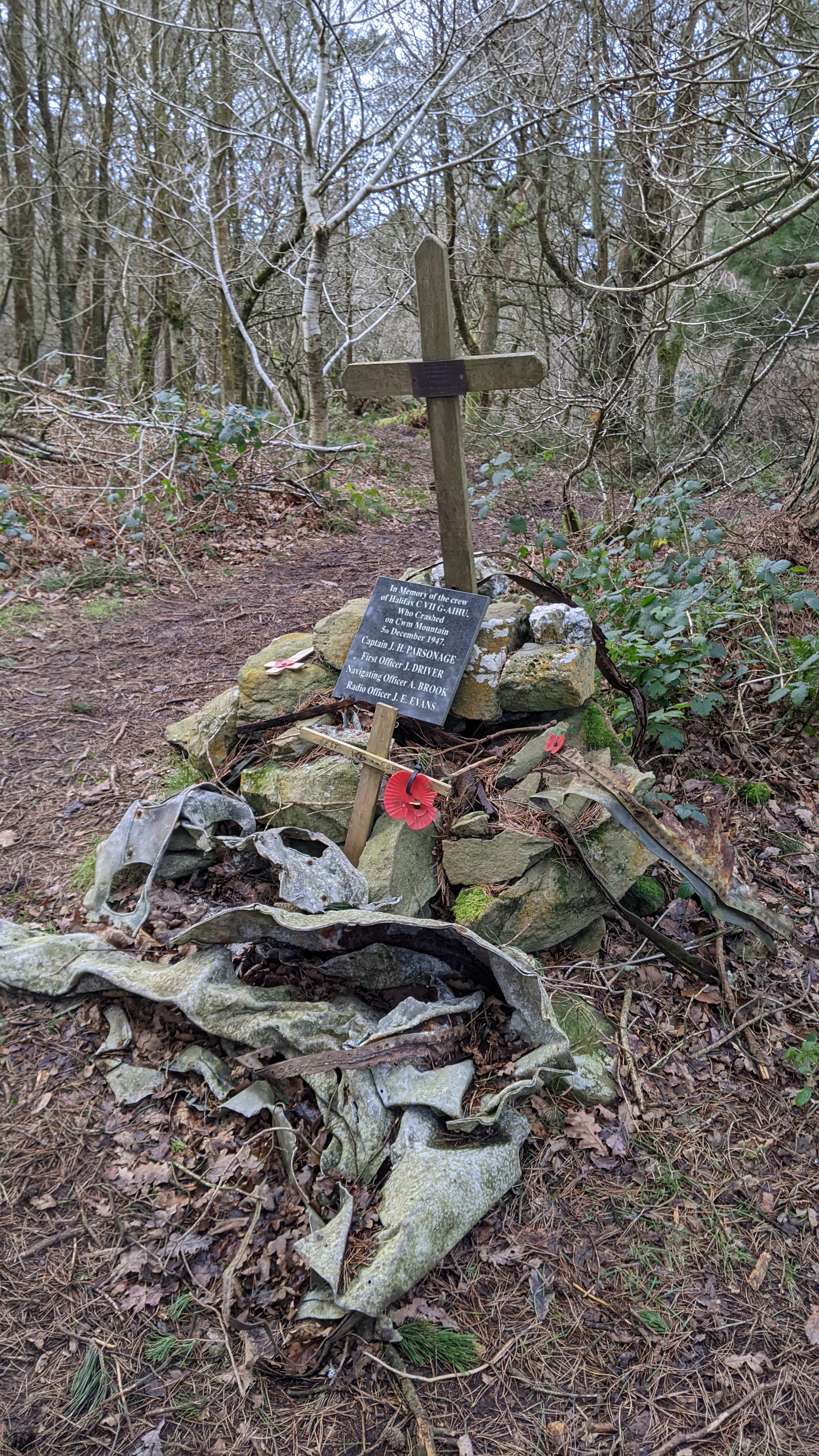
Coed Cwm Images

Images are sourced within 2km of 53.279369/-3.3917252 or Grid Reference SJ0776. Thanks to Geograph Open Source API. All images are credited.

Approaching the summit of Moel Hiraddug near Dyserth This path leads all the way to the summit from the south.
Approaching the summit of Moel Hiraddug near Dyserth
This path leads all the way to the summit from the south.
On the summit of  Moel Hiraddug with view towards Mynydd y Cwm
On the summit of Moel Hiraddug with view towards Mynydd y Cwm
Vale of Clwyd from Moel Hiraddug
The village church at Cwm near Dyserth
Plas yn Cwm near Rhuallt
On the Offa's Dyke Path north of Tyddyn-y-cyll with view to Gop Hill
A55 eastbound near Rhuallt
Cae indrawn / A maize field
Giat cae / A field gate The hill in the background is Moel Hiraddug.
Giat cae / A field gate
The hill in the background is Moel Hiraddug.
Blwch Post Sioraidd / A Georgian Postbox
Clytwaith o gaeau Dyffryn Clwyd / A patchwork of fields in the Vale of Clwyd
Tan-y-Bryn
Tan-y-Bryn
Ty Ucha
Ty Ucha
Tombstone of Grace Williams (d. 1642) An elaborate hooded tomb.
Tombstone of Grace Williams (d. 1642)
An elaborate hooded tomb.
Rock cutting, A55 The A55 is also known as the North Wales expressway. Originally it ran from Chester to Bangor, but was extended in 2001 across Anglesey to Holyhead. It is dual carriageway along its entire length.
Wikipedia: <span class="nowrap"><a title="http://en.wikipedia.org/wiki/A55_road" rel="nofollow ugc noopener" href="http://en.wikipedia.org/wiki/A55_road">Link</a><img style="margin-left:2px;" alt="External link" title="External link - shift click to open in new window" src="https://s1.geograph.org.uk/img/external.png" width="10" height="10"/></span>
Rock cutting, A55
The A55 is also known as the North Wales expressway. Originally it ran from Chester to Bangor, but was extended in 2001 across Anglesey to Holyhead. It is dual carriageway along its entire length. Wikipedia: LinkExternal link
A55, Junction 29 The A55 is also known as the North Wales expressway. Originally it ran from Chester to Bangor, but was extended in 2001 across Anglesey to Holyhead. It is dual carriageway along its entire length.
Wikipedia: <span class="nowrap"><a title="http://en.wikipedia.org/wiki/A55_road" rel="nofollow ugc noopener" href="http://en.wikipedia.org/wiki/A55_road">Link</a><img style="margin-left:2px;" alt="External link" title="External link - shift click to open in new window" src="https://s1.geograph.org.uk/img/external.png" width="10" height="10"/></span>
A55, Junction 29
The A55 is also known as the North Wales expressway. Originally it ran from Chester to Bangor, but was extended in 2001 across Anglesey to Holyhead. It is dual carriageway along its entire length. Wikipedia: LinkExternal link
A55, Rhuallt Hill The A55 is also known as the North Wales expressway. Originally it ran from Chester to Bangor, but was extended in 2001 across Anglesey to Holyhead. It is dual carriageway along its entire length.
Wikipedia: <span class="nowrap"><a title="http://en.wikipedia.org/wiki/A55_road" rel="nofollow ugc noopener" href="http://en.wikipedia.org/wiki/A55_road">Link</a><img style="margin-left:2px;" alt="External link" title="External link - shift click to open in new window" src="https://s1.geograph.org.uk/img/external.png" width="10" height="10"/></span>
A55, Rhuallt Hill
The A55 is also known as the North Wales expressway. Originally it ran from Chester to Bangor, but was extended in 2001 across Anglesey to Holyhead. It is dual carriageway along its entire length. Wikipedia: LinkExternal link
Footbridge crosses the A55 The A55 is also known as the North Wales expressway. Originally it ran from Chester to Bangor, but was extended in 2001 across Anglesey to Holyhead. It is dual carriageway along its entire length.
Wikipedia: <span class="nowrap"><a title="http://en.wikipedia.org/wiki/A55_road" rel="nofollow ugc noopener" href="http://en.wikipedia.org/wiki/A55_road">Link</a><img style="margin-left:2px;" alt="External link" title="External link - shift click to open in new window" src="https://s1.geograph.org.uk/img/external.png" width="10" height="10"/></span>
Footbridge crosses the A55
The A55 is also known as the North Wales expressway. Originally it ran from Chester to Bangor, but was extended in 2001 across Anglesey to Holyhead. It is dual carriageway along its entire length. Wikipedia: LinkExternal link
Show me another place!

Coed Cwm is located at Grid Ref: SJ0776 (Lat: 53.279369, Lng: -3.3917252)

Unitary Authority: Denbighshire

Police Authority: North Wales

Also known as: Mynydd y Cwm

What 3 Words

///surprise.brave.weeknight. Near Cwm, Denbighshire

Related Wikis

Mynydd y Cwm

Mynydd y Cwm is a hill in the Clwydian Range in Denbighshire, North Wales. It reaches a height of 304.8 metres (1,000 feet). It has recently been promoted...
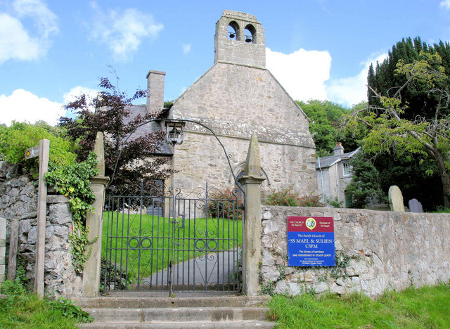
Cwm, Denbighshire

Cwm is a village and community in Denbighshire, below the hill Mynydd y Cwm. The church in Cwm is dedicated to two 6th-century saints, St Mael and St Sulien...

Rhuallt

Rhuallt is a village in Denbighshire, Wales. The village is situated approximately 5 mi (8.0 km) south of Prestatyn and 2 mi (3.2 km) east of St Asaph...

Moel Hiraddug

Moel Hiraddug, also known as Y Foel, is a hill fort and hill in the Clwydian Range of north-east Wales. The northern part of the hill has been eaten away...

Nearby Amenities

Located within 500m of 53.279369,-3.3917252
Mynydd Y Cwm
Ele: 302
Natural: peak
Wikidata: Q13130331
Lat/Long: 53.2795238/-3.3918941
Natural: spring
Lat/Long: 53.2834036/-3.3890536
Tumulus
Archaeological Site: tumulus
Historic: archaeological_site
Lat/Long: 53.2823963/-3.3863131
Natural: spring
Lat/Long: 53.2816863/-3.3950232
Power: pole
Lat/Long: 53.2832701/-3.3950512
The data included in this document is from www.openstreetmap.org. The data is made available under ODbL.

Have you been to Coed Cwm?

Leave your review of Coed Cwm below (or comments, questions and feedback).