Clogwyn Llech Lefn

Hill, Mountain in Caernarfonshire

Wales

Clogwyn Llech Lefn

Pony at the gateway One of the semi-wild Carneddau ponies, here standing (legitimately!) on the bridleway leading to Llyn Cowlyd
Pony at the gateway Credit: Richard Law

Clogwyn Llech Lefn is a prominent hill located in the county of Caernarfonshire, in northwestern Wales. It is situated in the Snowdonia National Park, around 5 miles southwest of the town of Caernarfon.

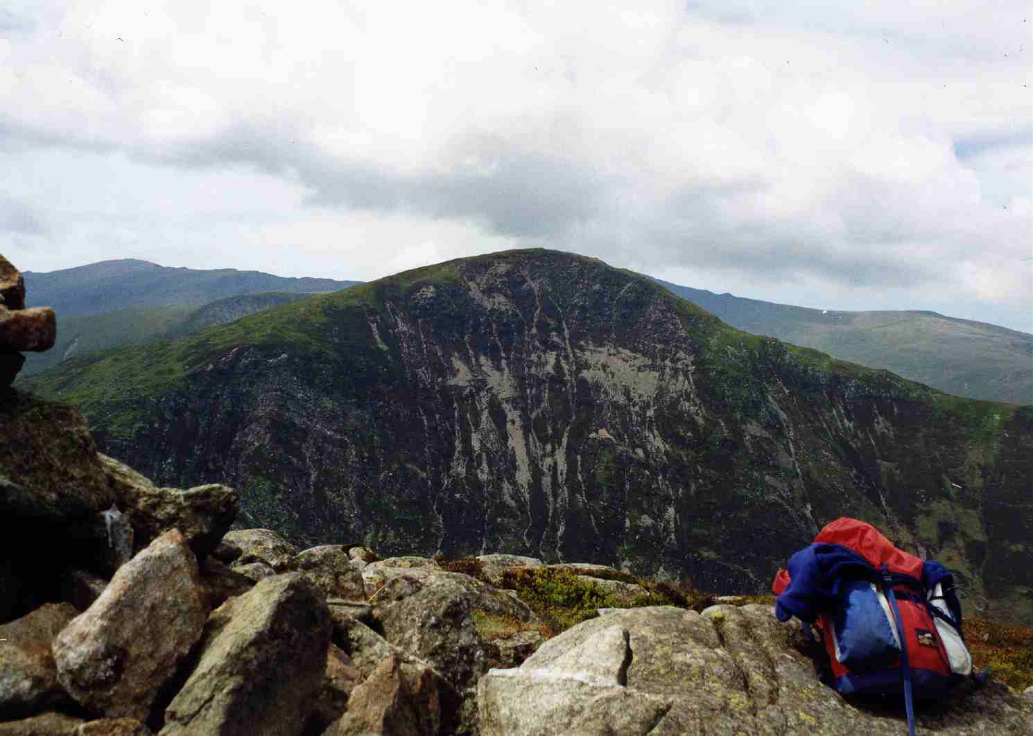
With an elevation of 396 meters (1,299 feet), Clogwyn Llech Lefn is not classified as a mountain, but rather a hill. However, it still offers breathtaking views of the surrounding landscape. The hill is characterized by steep, rocky slopes and is covered in heather and grass, adding to its natural beauty.

Clogwyn Llech Lefn is a popular destination for hikers and nature enthusiasts. Several walking trails, ranging in difficulty, allow visitors to explore the area and enjoy the stunning scenery. The summit provides panoramic views of the surrounding mountains, including the famous Snowdon, the highest peak in Wales.

The hill is also known for its rich historical and archaeological significance. It is home to ancient stone circles and standing stones, which are believed to date back to the Bronze Age. These remnants of the past add an extra layer of intrigue to the natural attraction.

Clogwyn Llech Lefn is easily accessible by road, with nearby parking available for visitors. The surrounding area offers a variety of amenities, including accommodation options and local eateries, making it a convenient and enjoyable destination for those looking to immerse themselves in the natural beauty and history of Caernarfonshire.

If you have any feedback on the listing, please let us know in the comments section below.

Clogwyn Llech Lefn Images

Images are sourced within 2km of 53.145959/-3.9317424 or Grid Reference SH7062. Thanks to Geograph Open Source API. All images are credited.

Pony at the gateway One of the semi-wild Carneddau ponies, here standing (legitimately!) on the bridleway leading to Llyn Cowlyd
Pony at the gateway
One of the semi-wild Carneddau ponies, here standing (legitimately!) on the bridleway leading to Llyn Cowlyd
Bwlch Cowlyd sheepfold Quite a substantial construction for a simple sheepfold, and quite clearly more rectangular than the normal circular affairs, which leads the Gwynedd Archaeological Trust to suspect it may have origins as a more formal building <span class="nowrap"><a title="https://coflein.gov.uk/en/site/533593/" rel="nofollow ugc noopener" href="https://coflein.gov.uk/en/site/533593/">Link</a><img style="margin-left:2px;" alt="External link" title="External link - shift click to open in new window" src="https://s1.geograph.org.uk/img/external.png" width="10" height="10"/></span>
Bwlch Cowlyd sheepfold
Quite a substantial construction for a simple sheepfold, and quite clearly more rectangular than the normal circular affairs, which leads the Gwynedd Archaeological Trust to suspect it may have origins as a more formal building LinkExternal link
Bwlch Cowlyd field wall Part of a much longer drystone wall, but here it forms the downhill revetment of what appears to be an agriculturally-improved field. Described by the Gwynedd Archaeological Trust at <span class="nowrap"><a title="https://coflein.gov.uk/en/site/533595/" rel="nofollow ugc noopener" href="https://coflein.gov.uk/en/site/533595/">Link</a><img style="margin-left:2px;" alt="External link" title="External link - shift click to open in new window" src="https://s1.geograph.org.uk/img/external.png" width="10" height="10"/></span>
Bwlch Cowlyd field wall
Part of a much longer drystone wall, but here it forms the downhill revetment of what appears to be an agriculturally-improved field. Described by the Gwynedd Archaeological Trust at LinkExternal link
A sheeptrack with a view Looking across the southern slopes of Pen Llithrig y Wrach to the hills on the other side of the Afon Llugwy. Visible are Gallt yr Ogof, Y Foel Goch, Glyder Fach (with Glyder Fawr just in the cloud), Tryfan, Y Garn with the high-hanging Cwm Clyd and lastly Pen Yr Ole Wen just peeping over the shoulder on the right.
A sheeptrack with a view
Looking across the southern slopes of Pen Llithrig y Wrach to the hills on the other side of the Afon Llugwy. Visible are Gallt yr Ogof, Y Foel Goch, Glyder Fach (with Glyder Fawr just in the cloud), Tryfan, Y Garn with the high-hanging Cwm Clyd and lastly Pen Yr Ole Wen just peeping over the shoulder on the right.
Fallen wall on the south ridge of Pen Llithrig y Wrach Presumably a post-medieval boundary wall that's now fallen (literally) into complete disuse, and hasn't been supplemented by a fence on the same alignment.
Fallen wall on the south ridge of Pen Llithrig y Wrach
Presumably a post-medieval boundary wall that's now fallen (literally) into complete disuse, and hasn't been supplemented by a fence on the same alignment.
View to the west-southwest Looking across the valley of the Afon Llugwy, to Gallt yr Ogof, the Glyder hills, Tryfan and Y Garn on the right.
View to the west-southwest
Looking across the valley of the Afon Llugwy, to Gallt yr Ogof, the Glyder hills, Tryfan and Y Garn on the right.
View to the west Slightly north of <a href="https://www.geograph.org.uk/photo/7624336">SH7162 : View to the west-southwest</a>, this time with the two Glyders (Fawr has a cap of cloud), then Tryfan, Y Garn and Pen yr Ole Wen on the right.
View to the west
Slightly north of SH7162 : View to the west-southwest, this time with the two Glyders (Fawr has a cap of cloud), then Tryfan, Y Garn and Pen yr Ole Wen on the right.
Path just south of the summit A hillwalkers' path across the short grass of the hillside just below the summit of Pen Llithrig y Wrach.
Path just south of the summit
A hillwalkers' path across the short grass of the hillside just below the summit of Pen Llithrig y Wrach.
Untidy summit cairn on Pen Llithrig y Wrach <a href="https://www.geograph.org.uk/photo/4866312">SH7162 : The summit cairn on Pen Llithrig y Wrach</a> suggests it was once a better-looking affair, but it's decidedly raggedy in late 2023. The Gwynedd Archaeological Trust, in their report <span class="nowrap"><a title="https://archwilio.org.uk/arch/query/page.php?watprn=GAT3779&dbname=gat&tbname=core" rel="nofollow ugc noopener" href="https://archwilio.org.uk/arch/query/page.php?watprn=GAT3779&dbname=gat&tbname=core">Link</a><img style="margin-left:2px;" alt="External link" title="External link - shift click to open in new window" src="https://s1.geograph.org.uk/img/external.png" width="10" height="10"/></span> describe the modern cairn as being situated on a low, well spread and grassed over, quite large cairn c. 9m diameter. This is slightly more evident from the north side <a href="https://www.geograph.org.uk/photo/7624359">SH7162 : Summit cairn on Pen Llithrig y Wrach</a> to be fair.
Untidy summit cairn on Pen Llithrig y Wrach
SH7162 : The summit cairn on Pen Llithrig y Wrach suggests it was once a better-looking affair, but it's decidedly raggedy in late 2023. The Gwynedd Archaeological Trust, in their report LinkExternal link describe the modern cairn as being situated on a low, well spread and grassed over, quite large cairn c. 9m diameter. This is slightly more evident from the north side SH7162 : Summit cairn on Pen Llithrig y Wrach to be fair.
Summit cairn on Pen Llithrig y Wrach From this side, the low edge of the older, flattened grassy cairn is more visible. It's described in <span class="nowrap"><a title="https://archwilio.org.uk/arch/query/page.php?watprn=GAT3779&dbname=gat&tbname=core" rel="nofollow ugc noopener" href="https://archwilio.org.uk/arch/query/page.php?watprn=GAT3779&dbname=gat&tbname=core">Link</a><img style="margin-left:2px;" alt="External link" title="External link - shift click to open in new window" src="https://s1.geograph.org.uk/img/external.png" width="10" height="10"/></span>
Summit cairn on Pen Llithrig y Wrach
From this side, the low edge of the older, flattened grassy cairn is more visible. It's described in LinkExternal link
Path across the NE shoulder of Pen Llithrig y Wrach This walkers' track makes for easy going across the rather boggy flat ground with some peat hags, heading for Moel Eilio in the distance.
Path across the NE shoulder of Pen Llithrig y Wrach
This walkers' track makes for easy going across the rather boggy flat ground with some peat hags, heading for Moel Eilio in the distance.
Peat hags high on Pen Llithrig y Wrach
Walkers' path heading across the NE shoulder of Pen Llithrig y Wrach
View uphill towards Pen Llithrig y Wrach A view back up the path to the upper part of the hill.
View uphill towards Pen Llithrig y Wrach
A view back up the path to the upper part of the hill.
An old boundary wall across the moorland Running roughly N - S, this post-medieval wall has seen better days.
An old boundary wall across the moorland
Running roughly N - S, this post-medieval wall has seen better days.
Down the hillside towards Llyn Eigiau A view from the moors on the northern side of Pen Llithrig y Wrach
Down the hillside towards Llyn Eigiau
A view from the moors on the northern side of Pen Llithrig y Wrach
Heading down the ridge above Clogwyn Du Clogwyn Du being the steep, craggy hillside offshot to the right, which drops down towards Llyn Cowlyd.
Heading down the ridge above Clogwyn Du
Clogwyn Du being the steep, craggy hillside offshot to the right, which drops down towards Llyn Cowlyd.
View to the west Across extensive moorland and the NE hillside of Pen Llithrig y Wrach, to the lumpy bulk of Pen yr Helgi Du, then Craig yr Ysfa (cliff in the sunshine) and Carnedd Llewelyn looming above that.
View to the west
Across extensive moorland and the NE hillside of Pen Llithrig y Wrach, to the lumpy bulk of Pen yr Helgi Du, then Craig yr Ysfa (cliff in the sunshine) and Carnedd Llewelyn looming above that.
Show me another place!

Clogwyn Llech Lefn is located at Grid Ref: SH7062 (Lat: 53.145959, Lng: -3.9317424)

Unitary Authority: Conwy

Police Authority: North Wales

Also known as: Bwlch y Tri Marchog Top

What 3 Words

///sensibly.locals.cobras. Near Bethesda, Gwynedd

Related Wikis

Pen Llithrig y Wrach

Pen Llithrig y Wrach is a mountain peak in Snowdonia, North Wales. It is one of the four Marilyns that make up the Carneddau range. To the east is Creigiau...

Pen yr Helgi Du

Pen yr Helgi Du (Head or Hill of the Black Hound) is a mountain peak in the eastern part of the Carneddau in Snowdonia, North Wales. It lies on the south...
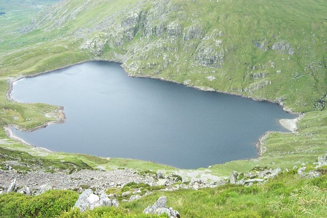
Ffynnon Llugwy

Ffynnon Llugwy (English: Llugwy spring) is a lake in the Carneddau range of mountains in Snowdonia, North Wales. It lies at a height of about 1,786 feet...

Llyn Cowlyd

Llyn Cowlyd is the deepest lake in northern Wales. It lies in the Snowdonia National Park at the upper end of Cwm Cowlyd on the south-eastern edge of...

Have you been to Clogwyn Llech Lefn?

Leave your review of Clogwyn Llech Lefn below (or comments, questions and feedback).