Edinburgh Hill
Hill, Mountain in Kent Dover
England
Edinburgh Hill
Edinburgh Hill is a prominent landmark located in the county of Kent, England. It is a picturesque hill/mountain that offers breathtaking views of the surrounding countryside. Standing at an elevation of approximately 450 meters, Edinburgh Hill is one of the highest points in the region, attracting both nature enthusiasts and hikers.
The hill is characterized by its distinctive rocky outcrops and lush greenery, creating a diverse and captivating landscape. The terrain is relatively steep, making it an ideal destination for those seeking a challenging climb. The summit of Edinburgh Hill provides an unparalleled panorama, offering vistas of rolling hills, dense forests, and meandering rivers.
Visitors to Edinburgh Hill can explore a network of well-maintained trails that wind through the hillside, catering to both experienced hikers and casual walkers. These paths meander through a variety of habitats, including woodlands, meadows, and heathlands, providing ample opportunities for wildlife spotting.
The hill's natural beauty is further enhanced by the presence of diverse flora and fauna. Rare plant species, including heather and gorse, flourish on the slopes, adding vibrant colors to the landscape. Birdwatchers can enjoy sightings of various avian species, such as buzzards, kestrels, and peregrine falcons, soaring above the hill.
Edinburgh Hill, with its scenic beauty and varied terrain, is a popular destination for outdoor activities and nature appreciation. Whether it is a challenging hike to the summit or a leisurely stroll through its captivating surroundings, Edinburgh Hill offers a memorable experience for visitors of all ages.
If you have any feedback on the listing, please let us know in the comments section below.
Edinburgh Hill Images
Images are sourced within 2km of 51.136951/1.3202384 or Grid Reference TR3242. Thanks to Geograph Open Source API. All images are credited.

Edinburgh Hill is located at Grid Ref: TR3242 (Lat: 51.136951, Lng: 1.3202384)
Administrative County: Kent
District: Dover
Police Authority: Kent
What 3 Words
///intent.veal.chops. Near Dover, Kent
Nearby Locations
Related Wikis

Fort Burgoyne
Fort Burgoyne, originally known as Castle Hill Fort, was built in the 1860s as one of the Palmerston forts around Dover in southeast England. It was built...
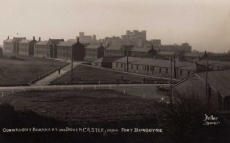
Connaught Barracks, Dover
Connaught Barracks, Dover was a military installation at Dover in Kent. == History == The barracks, which were built about half a mile south of Fort Burgoyne...

Dover Castle
Dover Castle is a medieval castle in Dover, Kent, England and is Grade I listed. It was founded in the 11th century and has been described as the "Key...
Duke of York's Royal Military School
The Duke of York's Royal Military School, more commonly known as the Duke of York's, is a co-educational academy (for students aged 11 to 18) with military...
Nearby Amenities
Located within 500m of 51.136951,1.3202384Have you been to Edinburgh Hill?
Leave your review of Edinburgh Hill below (or comments, questions and feedback).