St Ives Hill

Hill, Mountain in Essex Colchester

England

St Ives Hill

A nice view of Abberton Reservoir Well; wasn't it nice of the landowners to create a permissive path/bridleway that follows some sections of the reservoir; cos this really does make a good walk with plenty of superb views; like this one for instance. Reminds me of the beautiful river estuaries of the Colne & Stour in places. All that's needed is a path to connect Lodge Lane; Peldon to the B1026; so don't have to walk along a dangerous section of the Wigborough Road, like one has to do at the moment!
A nice view of Abberton Reservoir Credit: Mr James D

St Ives Hill is a prominent geographical feature located in Essex, England. Despite its name, it is not a true hill but rather a modest elevation in an otherwise flat landscape. Situated near the town of St Ives, the hill is approximately 50 meters high and offers commanding views of the surrounding countryside.

The hill is covered in lush grass and scattered with a variety of wildflowers, making it a popular spot for picnics and leisurely walks. It is accessible via a network of footpaths and trails that wind their way up the slope, providing visitors with an opportunity to explore the area's natural beauty.

The summit of St Ives Hill is crowned by a small copse of trees, providing shade and a peaceful atmosphere. From this vantage point, on a clear day, visitors can enjoy breathtaking vistas of the nearby villages, farmland, and the meandering River Stour.

The hill has historical significance as well, with evidence of human activity dating back to the Iron Age. Archaeological excavations have unearthed ancient artifacts, including pottery and tools, suggesting that the hill was once inhabited. Today, it is a protected site, and visitors are encouraged to respect its historical importance.

Overall, St Ives Hill is a charming destination for nature lovers and history enthusiasts alike. Its elevated position, combined with its picturesque surroundings, make it an ideal location for appreciating the beauty and tranquility of the Essex countryside.

If you have any feedback on the listing, please let us know in the comments section below.

St Ives Hill Images

Images are sourced within 2km of 51.814905/0.88341119 or Grid Reference TL9816. Thanks to Geograph Open Source API. All images are credited.

A nice view of Abberton Reservoir Well; wasn't it nice of the landowners to create a permissive path/bridleway that follows some sections of the reservoir; cos this really does make a good walk with plenty of superb views; like this one for instance. Reminds me of the beautiful river estuaries of the Colne & Stour in places. All that's needed is a path to connect Lodge Lane; Peldon to the B1026; so don't have to walk along a dangerous section of the Wigborough Road, like one has to do at the moment!
A nice view of Abberton Reservoir
Well; wasn't it nice of the landowners to create a permissive path/bridleway that follows some sections of the reservoir; cos this really does make a good walk with plenty of superb views; like this one for instance. Reminds me of the beautiful river estuaries of the Colne & Stour in places. All that's needed is a path to connect Lodge Lane; Peldon to the B1026; so don't have to walk along a dangerous section of the Wigborough Road, like one has to do at the moment!
Little Wigborough: Ploughed field
Little Wigborough: Wigborough Road
Peldon, St. Mary the Virgin's Church: Southern aspect
Peldon, St. Mary the Virgin's Church: South chancel wall with reused Roman tiles
Peldon, St. Mary the Virgin's Church: The font
Peldon, St. Mary the Virgin's Church: The nave
Peldon, St. Mary the Virgin's Church: Angel roof corbels
Peldon, St. Mary the Virgin's Church: One of two angel roof corbels
Peldon, St. Mary the Virgin's Church: Angel roof corbels
Peldon, St. Mary the Virgin's Church: Nativity scene
Peldon and Wigboroughs Community Hall
Peldon, St. Mary the Virgin's Church: Stained glass part of the Canon E.J. Lendon memorial window Canon Lendon was rector of the church from 1981-1989. The window is also a memorial to his wife, Mary.
Peldon, St. Mary the Virgin's Church: Stained glass part of the Canon E.J. Lendon memorial window
Canon Lendon was rector of the church from 1981-1989. The window is also a memorial to his wife, Mary.
Peldon, St. Mary the Virgin's Church: Stained glass window
Peldon, St. Mary the Virgin's Church: Six bay nave roof with hammerbeams 1
Peldon, St. Mary the Virgin's Church: Six bay nave roof with hammerbeams 2
Peldon, St. Mary the Virgin's Church: Six bay nave roof with hammerbeams 3
Show me another place!

St Ives Hill is located at Grid Ref: TL9816 (Lat: 51.814905, Lng: 0.88341119)

Administrative County: Essex

District: Colchester

Police Authority: Essex

What 3 Words

///ringside.unstable.blend. Near Layer de la Haye, Essex

Nearby Locations

St Ives Hill

Related Wikis

Peldon

Peldon is a village and civil parish in the Colchester borough of Essex, England. With Salcott, Virley, Great Wigborough and Little Wigborough, it forms...

1884 Colchester earthquake

The Colchester earthquake, also known as the Great English earthquake, occurred on the morning of 22 April 1884 at 09:18. It caused considerable damage...
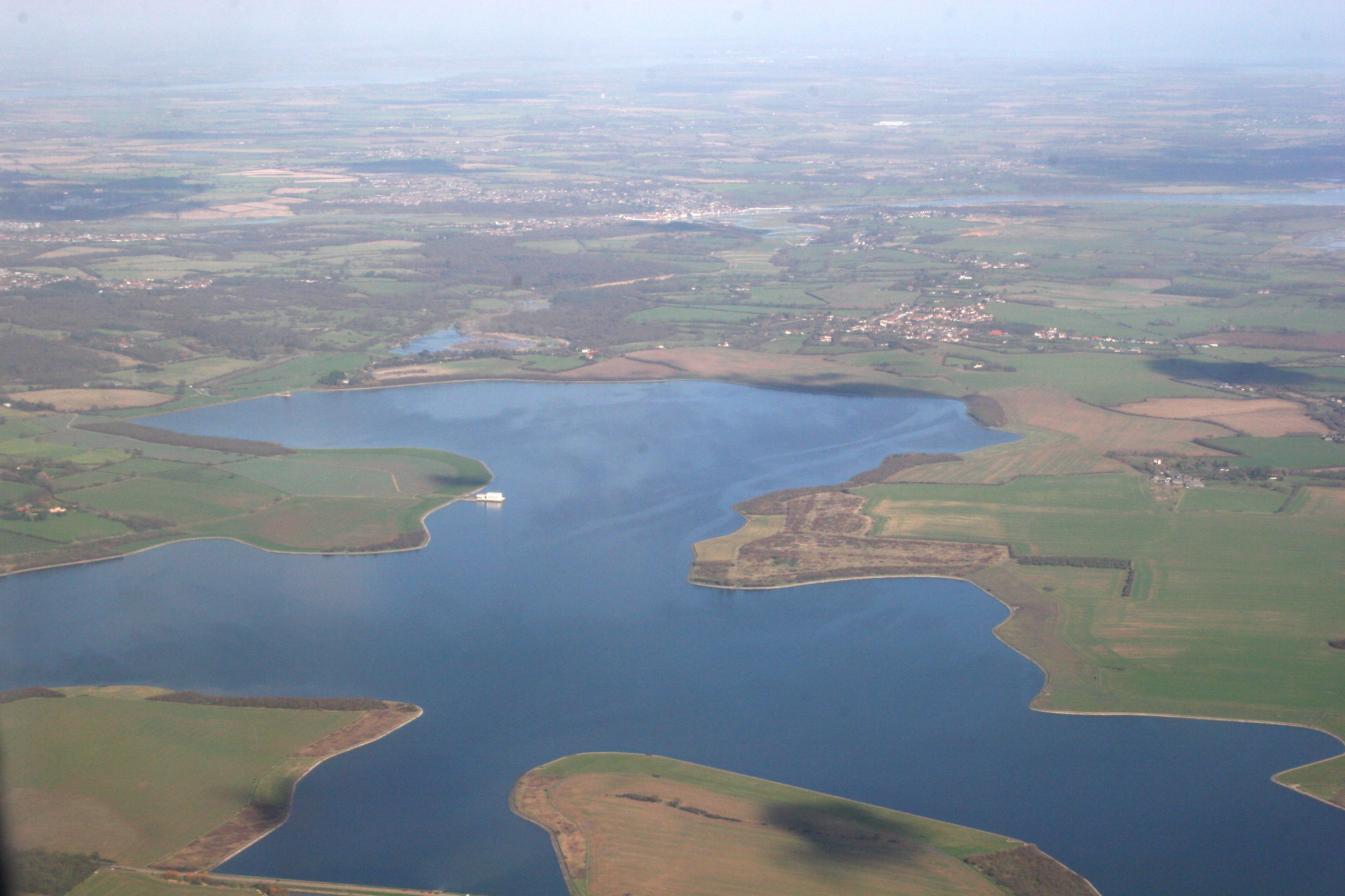
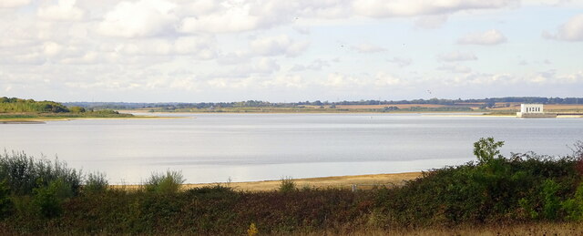
Abberton Reservoir

Abberton Reservoir is a pumped storage freshwater reservoir in eastern England near the Essex coast, with an area of 700 hectares (1,700 acres). Most of...

Little Wigborough

Little Wigborough is a village and former civil parish, now in the parish of Great and Little Wigborough, in the Colchester borough of Essex, England and...

Nearby Amenities

Located within 500m of 51.814905,0.88341119
Barrier: lift_gate
Bicycle: no
Foot: no
Lat/Long: 51.8152717/0.8846727
St. Ives Road
Naptan AtcoCode: 150014012003
Naptan Bearing: S
Naptan BusStopType: CUS
Naptan CommonName: St. Ives Road
Naptan Crossing: St. Ives Road
Naptan Indicator: Adj
Naptan Landmark: St. Ives Road
Naptan NaptanCode: esxdajwp
Naptan Street: Malting Road
Naptan Verified: no
Public Transport: platform
Source: naptan_import
Lat/Long: 51.815208/0.8866137
Lower Road
Naptan AtcoCode: 1500IM2489Y
Naptan Bearing: NW
Naptan BusStopType: CUS
Naptan CommonName: Lower Road
Naptan Crossing: Lower Road
Naptan Indicator: Adj
Naptan Landmark: Lower Road
Naptan NaptanCode: esxjdmjd
Naptan Street: St. Ives Road
Naptan Verified: no
Public Transport: platform
Source: naptan_import
Lat/Long: 51.8117709/0.8881352
St. Ives Road
Naptan AtcoCode: 1500TEMP0018
Naptan Bearing: NE
Naptan BusStopType: CUS
Naptan CommonName: St. Ives Road
Naptan Crossing: St. Ives Road
Naptan Indicator: Opp
Naptan Landmark: St. Ives Road
Naptan NaptanCode: esxgjdpj
Naptan Street: Church Road
Naptan Verified: no
Public Transport: platform
Source: naptan_import
Lat/Long: 51.8152554/0.8865152
Peldon
Place: village
Source: OS7
Lat/Long: 51.8122116/0.8850076
Post Box
Operator: Royal Mail
Operator Wikidata: Q638098
Post Box Mounting: pier
Post Box Type: lamp
Ref: CO5 204
Royal Cypher: EIIR
Royal Cypher Wikidata: Q33102113
Lat/Long: 51.8108692/0.8862308
Post Box
Collection Times: Mo-Fr 16:45; Sa 10:30
Fixme: is this is a D postbox? if so, check collection times,
Operator: Royal Mail
Operator Wikidata: Q638098
Ref: CO5 353D
Source: survey
Lat/Long: 51.8143395/0.8858039
Power: pole
Lat/Long: 51.8151765/0.8878192
Power: pole
Lat/Long: 51.8149245/0.8896941
Bench
Lat/Long: 51.8107516/0.8859265
Defibrillator
Access: yes
Defibrillator Location: to left side of front wall, facing car park
Emergency: defibrillator
Indoor: no
Ref GB The Circuit: 4F190DA8-05D7-4356-8524-ADEE00F24CAF
Lat/Long: 51.8143261/0.8853456
The data included in this document is from www.openstreetmap.org. The data is made available under ODbL.

Have you been to St Ives Hill?

Leave your review of St Ives Hill below (or comments, questions and feedback).