Springetts Hill

Hill, Mountain in Kent Tonbridge and Malling

England

Springetts Hill

Manningham House, Chapel St A small village in Tonbridge and Malling district of Kent.
Wikipedia: <span class="nowrap"><a title="https://en.wikipedia.org/wiki/East_Malling" rel="nofollow ugc noopener" href="https://en.wikipedia.org/wiki/East_Malling">Link</a><img style="margin-left:2px;" alt="External link" title="External link - shift click to open in new window" src="https://s1.geograph.org.uk/img/external.png" width="10" height="10"/></span>
Manningham House, Chapel St Credit: N Chadwick

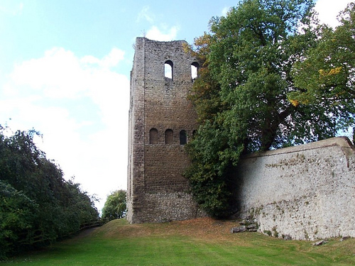
Springetts Hill is a scenic hill located in the county of Kent, England. Situated near the village of Wrotham, it is part of the North Downs, a range of chalk hills that stretches across southeast England. With an elevation of approximately 175 meters (574 feet), Springetts Hill offers breathtaking panoramic views of the surrounding countryside.

The hill is covered in lush greenery, with fields, woods, and meadows creating a picturesque landscape. It is home to a diverse range of flora and fauna, including wildflowers, butterflies, and various bird species. The area is a haven for nature enthusiasts and photographers, who flock to Springetts Hill to capture its natural beauty.

A network of footpaths and trails crisscross the hill, providing opportunities for hikers and walkers to explore the area. The paths lead visitors through rolling hills, offering glimpses of the neighboring countryside and charming villages in the distance. Springetts Hill is also a popular spot for picnics, with several designated areas offering stunning views for visitors to enjoy while they dine.

The hill is easily accessible by car, with parking available at designated spots nearby. It is also well-connected by public transport, with bus services running to the nearby village. Springetts Hill is a serene and tranquil destination, perfect for those seeking a peaceful retreat or a chance to reconnect with nature.

If you have any feedback on the listing, please let us know in the comments section below.

Springetts Hill Images

Images are sourced within 2km of 51.286035/0.42274172 or Grid Reference TQ6956. Thanks to Geograph Open Source API. All images are credited.

Manningham House, Chapel St A small village in Tonbridge and Malling district of Kent.
Wikipedia: <span class="nowrap"><a title="https://en.wikipedia.org/wiki/East_Malling" rel="nofollow ugc noopener" href="https://en.wikipedia.org/wiki/East_Malling">Link</a><img style="margin-left:2px;" alt="External link" title="External link - shift click to open in new window" src="https://s1.geograph.org.uk/img/external.png" width="10" height="10"/></span>
Manningham House, Chapel St
A small village in Tonbridge and Malling district of Kent. Wikipedia: LinkExternal link
Chapel St A small village in Tonbridge and Malling district of Kent.
Wikipedia: <span class="nowrap"><a title="https://en.wikipedia.org/wiki/East_Malling" rel="nofollow ugc noopener" href="https://en.wikipedia.org/wiki/East_Malling">Link</a><img style="margin-left:2px;" alt="External link" title="External link - shift click to open in new window" src="https://s1.geograph.org.uk/img/external.png" width="10" height="10"/></span>
Chapel St
A small village in Tonbridge and Malling district of Kent. Wikipedia: LinkExternal link
Holly Cottage A small village in Tonbridge and Malling district of Kent.
Wikipedia: <span class="nowrap"><a title="https://en.wikipedia.org/wiki/East_Malling" rel="nofollow ugc noopener" href="https://en.wikipedia.org/wiki/East_Malling">Link</a><img style="margin-left:2px;" alt="External link" title="External link - shift click to open in new window" src="https://s1.geograph.org.uk/img/external.png" width="10" height="10"/></span>
Holly Cottage
A small village in Tonbridge and Malling district of Kent. Wikipedia: LinkExternal link
Railway bridge, Chapel St A small village in Tonbridge and Malling district of Kent.
Wikipedia: <span class="nowrap"><a title="https://en.wikipedia.org/wiki/East_Malling" rel="nofollow ugc noopener" href="https://en.wikipedia.org/wiki/East_Malling">Link</a><img style="margin-left:2px;" alt="External link" title="External link - shift click to open in new window" src="https://s1.geograph.org.uk/img/external.png" width="10" height="10"/></span>
Railway bridge, Chapel St
A small village in Tonbridge and Malling district of Kent. Wikipedia: LinkExternal link
Boxtree House A small village in Tonbridge and Malling district of Kent.
Wikipedia: <span class="nowrap"><a title="https://en.wikipedia.org/wiki/East_Malling" rel="nofollow ugc noopener" href="https://en.wikipedia.org/wiki/East_Malling">Link</a><img style="margin-left:2px;" alt="External link" title="External link - shift click to open in new window" src="https://s1.geograph.org.uk/img/external.png" width="10" height="10"/></span>
Boxtree House
A small village in Tonbridge and Malling district of Kent. Wikipedia: LinkExternal link
East Malling Station A small village in Tonbridge and Malling district of Kent.
Wikipedia: <span class="nowrap"><a title="https://en.wikipedia.org/wiki/East_Malling" rel="nofollow ugc noopener" href="https://en.wikipedia.org/wiki/East_Malling">Link</a><img style="margin-left:2px;" alt="External link" title="External link - shift click to open in new window" src="https://s1.geograph.org.uk/img/external.png" width="10" height="10"/></span>
East Malling Station
A small village in Tonbridge and Malling district of Kent. Wikipedia: LinkExternal link
High st A small village in Tonbridge and Malling district of Kent.
Wikipedia: <span class="nowrap"><a title="https://en.wikipedia.org/wiki/East_Malling" rel="nofollow ugc noopener" href="https://en.wikipedia.org/wiki/East_Malling">Link</a><img style="margin-left:2px;" alt="External link" title="External link - shift click to open in new window" src="https://s1.geograph.org.uk/img/external.png" width="10" height="10"/></span>
High st
A small village in Tonbridge and Malling district of Kent. Wikipedia: LinkExternal link
Railway bridge, East Malling A small village in Tonbridge and Malling district of Kent.
Wikipedia: <span class="nowrap"><a title="https://en.wikipedia.org/wiki/East_Malling" rel="nofollow ugc noopener" href="https://en.wikipedia.org/wiki/East_Malling">Link</a><img style="margin-left:2px;" alt="External link" title="External link - shift click to open in new window" src="https://s1.geograph.org.uk/img/external.png" width="10" height="10"/></span>
Railway bridge, East Malling
A small village in Tonbridge and Malling district of Kent. Wikipedia: LinkExternal link
East Malling Station East Malling station is on the Maidstone East Line and is 59km from London Victoria. Services are run by Southeastern. The station opened in 1913.
Wikipedia: <span class="nowrap"><a title="https://en.wikipedia.org/wiki/East_Malling_railway_station" rel="nofollow ugc noopener" href="https://en.wikipedia.org/wiki/East_Malling_railway_station">Link</a><img style="margin-left:2px;" alt="External link" title="External link - shift click to open in new window" src="https://s1.geograph.org.uk/img/external.png" width="10" height="10"/></span>
East Malling Station
East Malling station is on the Maidstone East Line and is 59km from London Victoria. Services are run by Southeastern. The station opened in 1913. Wikipedia: LinkExternal link
Forge House A small village in Tonbridge and Malling district of Kent.
Wikipedia: <span class="nowrap"><a title="https://en.wikipedia.org/wiki/East_Malling" rel="nofollow ugc noopener" href="https://en.wikipedia.org/wiki/East_Malling">Link</a><img style="margin-left:2px;" alt="External link" title="External link - shift click to open in new window" src="https://s1.geograph.org.uk/img/external.png" width="10" height="10"/></span>
Forge House
A small village in Tonbridge and Malling district of Kent. Wikipedia: LinkExternal link
The Vicarage Grade II listed.
The Vicarage
Grade II listed.
Ingleside Grade II listed.
Ingleside
Grade II listed.
Ingleside Listed buildings and structures are officially designated as being of special architectural, historical or cultural significance. There are over half a million listed structures in the United Kingdom, covered by around 375,000 listings.
Listed status is more commonly associated with buildings or groups of buildings, however it can cover many other structures, including bridges, headstones, steps, ponds, monuments, walls, phone boxes, wrecks, parks, and heritage sites, and in more recent times a road crossing (Abbey Road) and graffiti art (Banksy 'Spy-booth') have been included.

In England and Wales there are three main listing designations;
Grade I (2.5%) - exceptional interest, sometimes considered to be internationally important.
Grade II* (5.5%) - particularly important buildings of more than special interest. 
Grade II (92%) - nationally important and of special interest. 

There are also locally listed structures (at the discretion of local authorities) using A, B and C designations.

In Scotland three classifications are also used but the criteria are different. There are around 47,500 Listed buildings.
Category A (8%)- generally equivalent to Grade I and II* in England and Wales
Category B (51%)- this appears generally to cover the ground of Grade II, recognising national importance.
Category C (41%)- buildings of local importance, probably with some overlap with English Grade II.

In Northern Ireland the criteria are similar to Scotland, but the classifications are:
Grade A (2.3%)
Grade B+ (4.7%)
Grade B (93%)

Read more at Wikipedia <span class="nowrap"><a title="http://en.wikipedia.org/wiki/Listed_building" rel="nofollow ugc noopener" href="http://en.wikipedia.org/wiki/Listed_building">Link</a><img style="margin-left:2px;" alt="External link" title="External link - shift click to open in new window" src="https://s1.geograph.org.uk/img/external.png" width="10" height="10"/></span>
Ingleside
Listed buildings and structures are officially designated as being of special architectural, historical or cultural significance. There are over half a million listed structures in the United Kingdom, covered by around 375,000 listings. Listed status is more commonly associated with buildings or groups of buildings, however it can cover many other structures, including bridges, headstones, steps, ponds, monuments, walls, phone boxes, wrecks, parks, and heritage sites, and in more recent times a road crossing (Abbey Road) and graffiti art (Banksy 'Spy-booth') have been included. In England and Wales there are three main listing designations; Grade I (2.5%) - exceptional interest, sometimes considered to be internationally important. Grade II* (5.5%) - particularly important buildings of more than special interest. Grade II (92%) - nationally important and of special interest. There are also locally listed structures (at the discretion of local authorities) using A, B and C designations. In Scotland three classifications are also used but the criteria are different. There are around 47,500 Listed buildings. Category A (8%)- generally equivalent to Grade I and II* in England and Wales Category B (51%)- this appears generally to cover the ground of Grade II, recognising national importance. Category C (41%)- buildings of local importance, probably with some overlap with English Grade II. In Northern Ireland the criteria are similar to Scotland, but the classifications are: Grade A (2.3%) Grade B+ (4.7%) Grade B (93%) Read more at Wikipedia LinkExternal link
King & Queen Grade II listed.
King & Queen
Grade II listed.
East Malling War Memorial Listed buildings and structures are officially designated as being of special architectural, historical or cultural significance. There are over half a million listed structures in the United Kingdom, covered by around 375,000 listings.
Listed status is more commonly associated with buildings or groups of buildings, however it can cover many other structures, including bridges, headstones, steps, ponds, monuments, walls, phone boxes, wrecks, parks, and heritage sites, and in more recent times a road crossing (Abbey Road) and graffiti art (Banksy 'Spy-booth') have been included.

In England and Wales there are three main listing designations;
Grade I (2.5%) - exceptional interest, sometimes considered to be internationally important.
Grade II* (5.5%) - particularly important buildings of more than special interest. 
Grade II (92%) - nationally important and of special interest. 

There are also locally listed structures (at the discretion of local authorities) using A, B and C designations.

In Scotland three classifications are also used but the criteria are different. There are around 47,500 Listed buildings.
Category A (8%)- generally equivalent to Grade I and II* in England and Wales
Category B (51%)- this appears generally to cover the ground of Grade II, recognising national importance.
Category C (41%)- buildings of local importance, probably with some overlap with English Grade II.

In Northern Ireland the criteria are similar to Scotland, but the classifications are:
Grade A (2.3%)
Grade B+ (4.7%)
Grade B (93%)

Read more at Wikipedia <span class="nowrap"><a title="http://en.wikipedia.org/wiki/Listed_building" rel="nofollow ugc noopener" href="http://en.wikipedia.org/wiki/Listed_building">Link</a><img style="margin-left:2px;" alt="External link" title="External link - shift click to open in new window" src="https://s1.geograph.org.uk/img/external.png" width="10" height="10"/></span>
East Malling War Memorial
Listed buildings and structures are officially designated as being of special architectural, historical or cultural significance. There are over half a million listed structures in the United Kingdom, covered by around 375,000 listings. Listed status is more commonly associated with buildings or groups of buildings, however it can cover many other structures, including bridges, headstones, steps, ponds, monuments, walls, phone boxes, wrecks, parks, and heritage sites, and in more recent times a road crossing (Abbey Road) and graffiti art (Banksy 'Spy-booth') have been included. In England and Wales there are three main listing designations; Grade I (2.5%) - exceptional interest, sometimes considered to be internationally important. Grade II* (5.5%) - particularly important buildings of more than special interest. Grade II (92%) - nationally important and of special interest. There are also locally listed structures (at the discretion of local authorities) using A, B and C designations. In Scotland three classifications are also used but the criteria are different. There are around 47,500 Listed buildings. Category A (8%)- generally equivalent to Grade I and II* in England and Wales Category B (51%)- this appears generally to cover the ground of Grade II, recognising national importance. Category C (41%)- buildings of local importance, probably with some overlap with English Grade II. In Northern Ireland the criteria are similar to Scotland, but the classifications are: Grade A (2.3%) Grade B+ (4.7%) Grade B (93%) Read more at Wikipedia LinkExternal link
4 - 6, Church Walk Grade II* listed.
4 - 6, Church Walk
Grade II* listed.
Church of St James Grade I listed, 12th century, ragstone built church. <span class="nowrap"><a title="https://historicengland.org.uk/listing/the-list/list-entry/1099148?section=official-listing" rel="nofollow ugc noopener" href="https://historicengland.org.uk/listing/the-list/list-entry/1099148?section=official-listing">Link</a><img style="margin-left:2px;" alt="External link" title="External link - shift click to open in new window" src="https://s1.geograph.org.uk/img/external.png" width="10" height="10"/></span>
Church of St James
Grade I listed, 12th century, ragstone built church. LinkExternal link
Show me another place!

Springetts Hill is located at Grid Ref: TQ6956 (Lat: 51.286035, Lng: 0.42274172)

Administrative County: Kent

District: Tonbridge and Malling

Police Authority: Kent

What 3 Words

///delusions.kneeled.rescuer. Near West Malling, Kent

Related Wikis

East Malling Stream

The East Malling Stream, known locally as "The Stream", rises at Well Street, East Malling, Kent, and flows in a generally easterly direction to join the...

West Malling railway station

West Malling railway station (sometimes shown as West Malling for Kings Hill) lies to the east of West Malling, Kent, England, and is close to Kings Hill...

West Malling

West Malling ( MAW-ling, historically Town Malling) is a market town in the Tonbridge and Malling district of Kent, England. It has a population of 2,590...

The Malling School

The Malling School is a mixed high school located in East Malling in the English county of Kent. == History == It opened as Clare Secondary School in 1957...

Related Videos

Walking West Malling 4K HD | Beautiful Kent Market Town | August 2022

A sunny afternoon walk in West Malling, Kent, UK. A short relaxing stroll, taking in the street cafes, pubs, shops and the beautiful ...

Is West Malling Kent's Most Beautiful Village? (Kent Travel Vlog)

We've heard good things about West Malling so we decided to head to this quiet Kent village to see what all the fuss is about.

Trouble Ahead - Nick Woods (Live at Beechsound Studio)

Thanks to Adam at Beechsound Studio for recording this song. Find us on Instagram, Facebook and TikTok. As always, thanks for ...

Nearby Amenities

Located within 500m of 51.286035,0.42274172
Crossing
Bicycle: yes
Button Operated: yes
Crossing: traffic_signals
Tactile Paving: yes
Traffic Signals Sound: no
Traffic Signals Vibration: no
Lat/Long: 51.289329/0.4182434
Broadwater Farm
Landuse: farm
Note Retag: CS #48756035
Source: OS7
Lat/Long: 51.2838603/0.4205198
Traffic Signals
Traffic Signals: pedestrian_crossing
Traffic Signals Direction: forward
Lat/Long: 51.2893812/0.4183139
Generator Method: photovoltaic
Generator Output Electricity: yes
Generator Source: solar
Generator Type: solar_photovoltaic_panel
Location: roof
Power: generator
Lat/Long: 51.2867111/0.420333
Colour: white
Marker: post
Material: concrete
Utility: oil
Lat/Long: 51.2816098/0.4222531
Colour: white
Inscription: TG OIL PIPELINE
Marker: post
Material: concrete
Utility: oil
Lat/Long: 51.2816567/0.4222461
Colour: white
Inscription: TG OIL PIPELINE
Marker: post
Material: concrete
Utility: oil
Lat/Long: 51.2817063/0.4222325
The data included in this document is from www.openstreetmap.org. The data is made available under ODbL.

Have you been to Springetts Hill?

Leave your review of Springetts Hill below (or comments, questions and feedback).