Mill Hill

Hill, Mountain in Huntingdonshire Huntingdonshire

England

Mill Hill

Mere Way crossing A14
Mere Way crossing A14 Credit: Dave Thompson

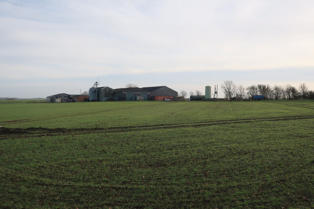
Mill Hill is a small hill located in the district of Huntingdonshire, Cambridgeshire, England. Situated near the market town of Huntingdon, it is a prominent geographical feature in the area. Despite its name, Mill Hill is not a mountain but rather a modest elevation that offers picturesque views of the surrounding countryside.

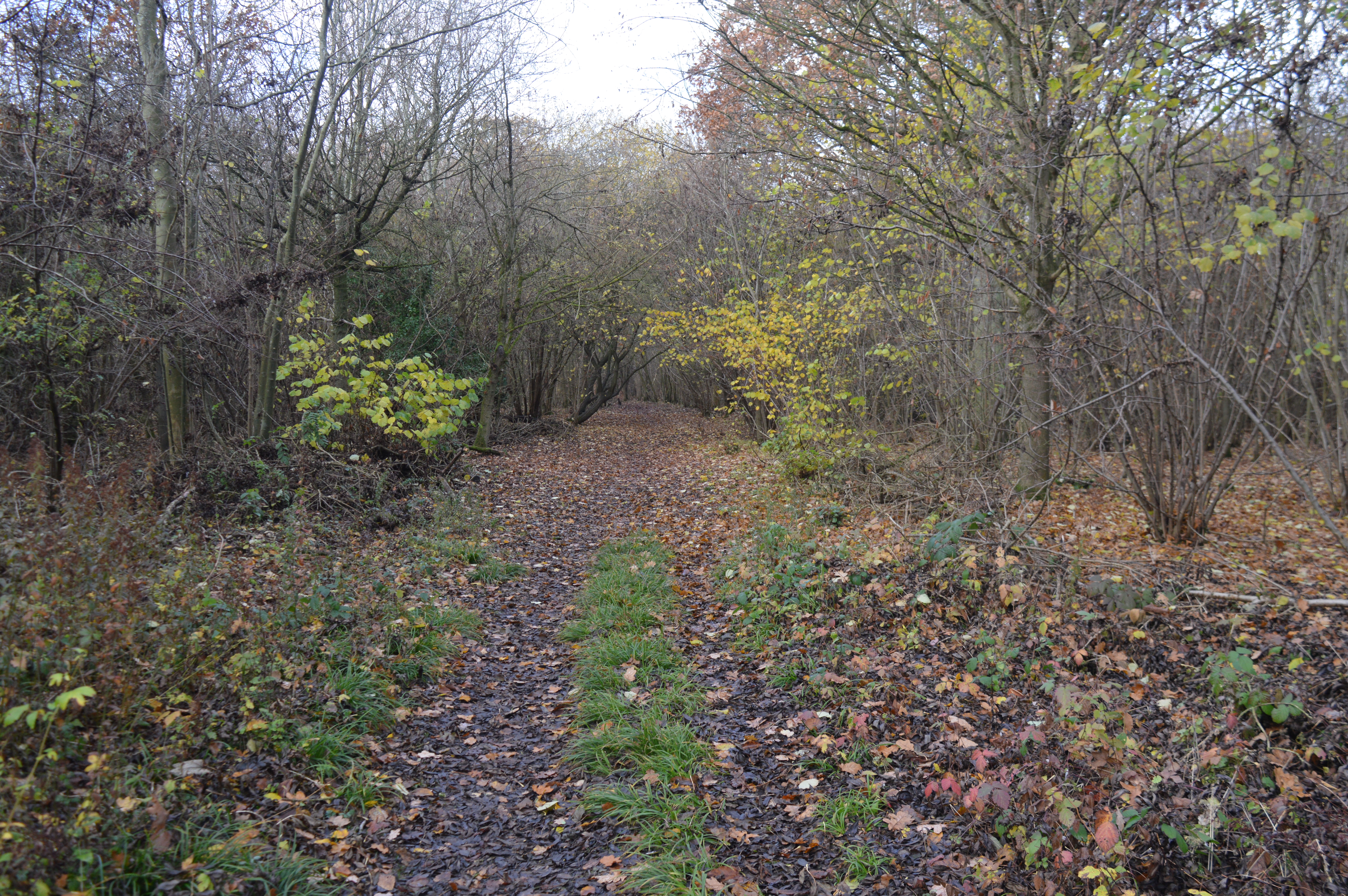
The hill is covered in lush greenery, with a mix of trees and shrubs adorning its slopes. It serves as a popular spot for locals and visitors alike, who often come here to enjoy walks, picnics, and outdoor activities. The terrain is gentle and suitable for all ages and fitness levels.

At the summit of Mill Hill, there is a small monument or marker that indicates the highest point. From this vantage point, one can admire the panoramic vistas of the rolling Huntingdonshire landscape, including nearby villages, farmland, and the River Great Ouse that meanders through the region.

The hill is easily accessible, with several footpaths and trails leading to its summit. It attracts hikers, nature enthusiasts, and families looking for a peaceful getaway. During the spring and summer months, the hillside is adorned with colorful wildflowers, adding to its natural beauty.

Mill Hill is steeped in history and folklore, with tales of ancient settlements and archaeological discoveries in the vicinity. The area is also home to a variety of wildlife, including birds, rabbits, and occasional deer sightings.

Overall, Mill Hill offers a tranquil and scenic retreat for those seeking a connection with nature and a break from the hustle and bustle of everyday life.

If you have any feedback on the listing, please let us know in the comments section below.

Mill Hill Images

Images are sourced within 2km of 52.277434/-0.11345644 or Grid Reference TL2866. Thanks to Geograph Open Source API. All images are credited.

Mere Way crossing A14
B1040 crossing the A14
Hilton Parish Church
The B1040 approaching Hilton
The B1040 leaving Hilton
Benchmark on St Mary Magdalene Church Hilton A cut mark at the west end of the church.  It is well defined and it appears as if it might be a modern reinstatement.
Benchmark on St Mary Magdalene Church Hilton
A cut mark at the west end of the church. It is well defined and it appears as if it might be a modern reinstatement.
Ducks with ducklings at the duckpond in Hilton
Ducklings at Hilton
Ducklings at Hilton
Graveley Way Graveley Way a country road passing through farmland near Hilton.  A very similar picture to this view five years ago <a href="https://www.geograph.org.uk/photo/5592492">TL2765 : Graveley Way</a>.
Graveley Way
Graveley Way a country road passing through farmland near Hilton. A very similar picture to this view five years ago TL2765 : Graveley Way.
Rogues Lane
Rogues Lane
Field by Rogues Cottage
Bridleway to Pitt Dene Farm
Bridleway to Hilton
Bridleway to Hilton
Field by Pitt Dene Farm
Permissive path around horse paddocks
Bridleway to Hilton
Bridleway to Hilton
Bridleway to Hilton
Bridleway to Hilton
Farmland south of Hilton
Show me another place!

Mill Hill is located at Grid Ref: TL2866 (Lat: 52.277434, Lng: -0.11345644)

Administrative County: Cambridgeshire

District: Huntingdonshire

Police Authority: Cambridgeshire

What 3 Words

///mixing.shared.groomed. Near Hilton, Cambridgeshire

Nearby Locations

Mill Hill Hilton

Related Wikis

Hilton, Cambridgeshire

Hilton is a village and civil parish in Cambridgeshire, England. Hilton lies approximately 11 miles (18 km) north-west of Cambridge. Hilton is situated...

Hilton Hall, Cambridgeshire

Hilton Hall is an early 17th-century English country house in the village of Hilton in Cambridgeshire. The hall is listed Grade II* on the National Heritage...

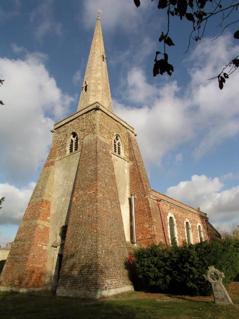
St John the Baptist's Church, Papworth St Agnes

St John the Baptist's Church is a redundant Anglican church in the village of Papworth St Agnes, Cambridgeshire, England. It is recorded in the National...

Papworth St Agnes

Papworth St Agnes is a village and civil parish in South Cambridgeshire, England. The population of the village is included in the civil parish of Graveley...

Papworth Everard

Papworth Everard is a village in Cambridgeshire, England. It lies ten miles west of Cambridge and six miles south of Huntingdon. Running through its centre...

Papworth Wood

Papworth Wood is an 8.7-hectare (21-acre) biological Site of Special Scientific Interest in Papworth Everard in Cambridgeshire.This is one of the oldest...

Hemingford Grey Meadow

Hemingford Grey Meadow is a 0.7-hectare (1.7-acre) biological Site of Special Scientific Interest south of Hemingford Grey in Cambridgeshire. It is managed...

Conington, South Cambridgeshire

Conington (Conington St Mary, or Coningtom-juxta-Cantab) is a small village in the South Cambridgeshire district of Cambridgeshire with about 50 houses...

Nearby Amenities

Located within 500m of 52.277434,-0.11345644
Hilton
Is In: Cambridgeshire, England, UK
Place: village
Wikidata: Q2713484
Lat/Long: 52.2799974/-0.1093715
Post Box
Ref: PE28 223
Lat/Long: 52.2791025/-0.1074183
Mill Hill
Created By: Potlatch 0.10b
Natural: hill
Place: locality
Source: npe
Lat/Long: 52.2787127/-0.1172338
Bus Stop
Scotts Crescent
Naptan AtcoCode: 0500HHILT003
Naptan Bearing: N
Naptan CommonName: Scotts Crescent
Naptan Indicator: opp
Naptan Landmark: Scotts Crescent
Naptan NaptanCode: cmbdpdwt
Naptan ShortCommonName: Scotts Crescent
Naptan Street: Potton Road
Naptan Verified: no
Source: naptan_import
Lat/Long: 52.2802247/-0.1118781
Bus Stop
Scotts Crescent
Naptan AtcoCode: 0500HHILT004
Naptan Bearing: N
Naptan BusStopType: CUS
Naptan CommonName: Scotts Crescent
Naptan Indicator: near
Naptan Landmark: Scotts Crescent
Naptan NaptanCode: cmbdpgad
Naptan ShortCommonName: Scotts Crescent
Naptan Street: Potton Road
Naptan Verified: no
Source: naptan_import
Lat/Long: 52.2802136/-0.1117466
Power: pole
Lat/Long: 52.2756969/-0.1116181
Power: pole
Lat/Long: 52.2734982/-0.1120627
Power: pole
Lat/Long: 52.2764424/-0.1114404
Access: yes
Depth: 0.3
Ford: yes
Motor Vehicle: yes
Seasonal: no
Lat/Long: 52.2781644/-0.1080211
Power: pole
Source: esri
Lat/Long: 52.2745976/-0.1118404
Shop: convenience
Lat/Long: 52.2782886/-0.1123229
Post Box
Ref: PE28 96
Lat/Long: 52.2783445/-0.112359
Historic: milestone
Inscription: Potton 12 miles. St Ives 4 miles.
Wikidata: Q26456795
Lat/Long: 52.2784798/-0.1125844
Sparrow's Monument
HE Ref: 1163202
Listed Status: Grade II
Man Made: obelisk
Wikidata: Q26456775
Lat/Long: 52.2789657/-0.1069278
Board Title: Welcome to Hilton
Board Type: history
Information: board
Tourism: information
Lat/Long: 52.2788357/-0.1070233
Bench
Backrest: yes
Inscription: Original bench presented by Hilton WI to commemorate The Silver Jubilee 1977 & Diamond Jubilee 2012 The original WI bench has been kindly replaced by Hilton Town Trust 2021
Material: wood
Lat/Long: 52.2789915/-0.1067016
Bench
Backrest: yes
Material: wood
Lat/Long: 52.2790648/-0.1068795
Bench
Backrest: yes
Material: wood
Lat/Long: 52.2790007/-0.1070911
Leisure: picnic_table
Lat/Long: 52.2790592/-0.1066477
Ford: yes
Lat/Long: 52.2780044/-0.1088499
The data included in this document is from www.openstreetmap.org. The data is made available under ODbL.

Have you been to Mill Hill?

Leave your review of Mill Hill below (or comments, questions and feedback).