Chesterton Hill

Hill, Mountain in Huntingdonshire Huntingdonshire

England

Chesterton Hill

Stubble field by the A605 The A605 is hidden by the trees on the left.
Stubble field by the A605 Credit: Jonathan Thacker

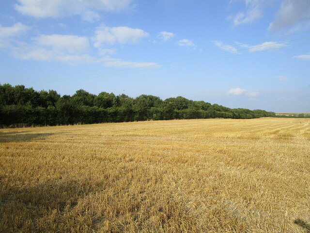
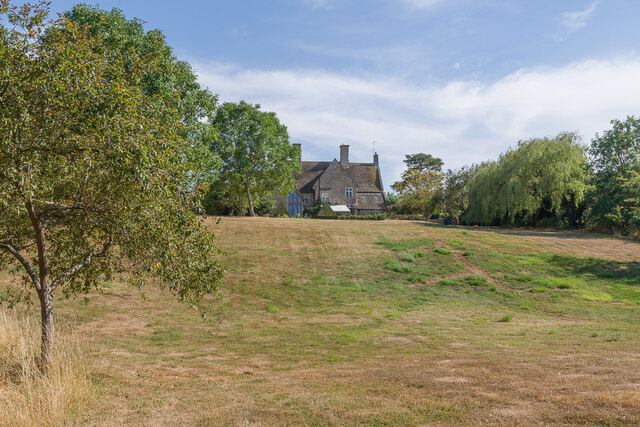
Chesterton Hill, located in Huntingdonshire, is a prominent geographical feature that stands tall amidst the idyllic English countryside. Rising to an elevation of approximately 98 meters, it is categorized as a hill rather than a mountain due to its moderate height. Situated near the village of Chesterton, this natural landmark offers breathtaking panoramic views of the surrounding area.

Covered in lush greenery, Chesterton Hill boasts a diverse range of flora and fauna, making it a haven for nature enthusiasts. The hill is home to various species of trees, including oak, beech, and ash, while the woodland areas provide shelter to an array of wildlife, such as deer, foxes, and rabbits.

The hill is accessible via a network of footpaths and trails that wind their way through the picturesque countryside. These paths attract hikers, walkers, and joggers who seek to explore the natural beauty of the area. Additionally, the hill offers a challenging terrain for those interested in outdoor activities such as hill running and orienteering.

Chesterton Hill has a rich historical significance, with evidence of human occupation dating back thousands of years. Archaeological finds suggest that the hill was utilized as a settlement during the Iron Age, and remnants of ancient earthworks can still be seen today. These historical features contribute to the overall charm and intrigue of Chesterton Hill.

Overall, Chesterton Hill is a remarkable natural landmark in Huntingdonshire, offering a combination of stunning scenery, diverse wildlife, and historical significance. It serves as a cherished destination for both locals and visitors, providing an opportunity to connect with nature and immerse oneself in the beauty of the English countryside.

If you have any feedback on the listing, please let us know in the comments section below.

Chesterton Hill Images

Images are sourced within 2km of 52.536793/-0.33865962 or Grid Reference TL1294. Thanks to Geograph Open Source API. All images are credited.

Stubble field by the A605 The A605 is hidden by the trees on the left.
Stubble field by the A605
The A605 is hidden by the trees on the left.
Alwalton Lock A common lock type on the Nene: a steel guillotine lock gate on the downstream side, and 'conventional' double 'V door', wooden gates upstream.
Alwalton Lock
A common lock type on the Nene: a steel guillotine lock gate on the downstream side, and 'conventional' double 'V door', wooden gates upstream.
Alwalton, St Andrew
Alwalton, St Andrew
Chesterton, St Michael
Peterborough Services At the A1/A1(M)/A605/A1139 interchange. Looking west, from the entrance to the Extra concourse.
Peterborough Services
At the A1/A1(M)/A605/A1139 interchange. Looking west, from the entrance to the Extra concourse.
Peterborough Services At the A1/A1(M)/A605/A1139 interchange. Looking northwest, from the entrance to the Extra concourse.
Peterborough Services
At the A1/A1(M)/A605/A1139 interchange. Looking northwest, from the entrance to the Extra concourse.
Peterborough Services At the A1/A1(M)/A605/A1139 interchange. Looking south to the entrance to the Extra concourse.
Peterborough Services
At the A1/A1(M)/A605/A1139 interchange. Looking south to the entrance to the Extra concourse.
Peterborough Services At the A1/A1(M)/A605/A1139 interchange. Looking northeast, from the entrance to the Extra concourse.
Peterborough Services
At the A1/A1(M)/A605/A1139 interchange. Looking northeast, from the entrance to the Extra concourse.
Arbroath Gardens Cul-de-sac off Loch Lomond Way, completed in 2005.
Arbroath Gardens
Cul-de-sac off Loch Lomond Way, completed in 2005.
Loch Fyne Close Cul-de-sac off Loch Lomond Way, completed in 2004.
Loch Fyne Close
Cul-de-sac off Loch Lomond Way, completed in 2004.
Loch Lomond Way Entrance to Loch Lomond Way serving an early 2000s estate.  Behind the fence on the right is the East of England Showground.
Loch Lomond Way
Entrance to Loch Lomond Way serving an early 2000s estate. Behind the fence on the right is the East of England Showground.
64 Innovation Way Office block near the entrance to the Peterborough Business Park, occupied by AB Agri, part of the Associated British Foods.
64 Innovation Way
Office block near the entrance to the Peterborough Business Park, occupied by AB Agri, part of the Associated British Foods.
Back Dike Side stream of the River Nene, seen here as it rejoins the main river.
Back Dike
Side stream of the River Nene, seen here as it rejoins the main river.
The Manor House 17th Century manor house with subsequent additions, set at the top of a lawn leading down to the River Nene.  Grade II* listed - see <span class="nowrap"><a title="https://historicengland.org.uk/listing/the-list/list-entry/1164628?section=official-list-entry" rel="nofollow ugc noopener" href="https://historicengland.org.uk/listing/the-list/list-entry/1164628?section=official-list-entry">Link</a><img style="margin-left:2px;" alt="External link" title="External link - shift click to open in new window" src="https://s1.geograph.org.uk/img/external.png" width="10" height="10"/></span>.
The Manor House
17th Century manor house with subsequent additions, set at the top of a lawn leading down to the River Nene. Grade II* listed - see LinkExternal link.
River Nene The River Nene as it flows past Alwalton.
River Nene
The River Nene as it flows past Alwalton.
Alwalton Lodge Early 19th Century lodge, reusing the 17th Century porch from the poet John Dryden's House in nearby Chesterton, since demolished.  It is now in the care of the Landmark Trust.  Grade II* listed - see <span class="nowrap"><a title="https://historicengland.org.uk/listing/the-list/list-entry/1130085?section=official-list-entry" rel="nofollow ugc noopener" href="https://historicengland.org.uk/listing/the-list/list-entry/1130085?section=official-list-entry">Link</a><img style="margin-left:2px;" alt="External link" title="External link - shift click to open in new window" src="https://s1.geograph.org.uk/img/external.png" width="10" height="10"/></span>.
Alwalton Lodge
Early 19th Century lodge, reusing the 17th Century porch from the poet John Dryden's House in nearby Chesterton, since demolished. It is now in the care of the Landmark Trust. Grade II* listed - see LinkExternal link.
Mill Lane Looking along Mill Lane to its junction with Church Street.  On the left is the former coach house and stables to the Old Rectory, built originally in c.1853.  Grade II listed - see <span class="nowrap"><a title="https://historicengland.org.uk/listing/the-list/list-entry/1317707?section=official-list-entry" rel="nofollow ugc noopener" href="https://historicengland.org.uk/listing/the-list/list-entry/1317707?section=official-list-entry">Link</a><img style="margin-left:2px;" alt="External link" title="External link - shift click to open in new window" src="https://s1.geograph.org.uk/img/external.png" width="10" height="10"/></span>.
Mill Lane
Looking along Mill Lane to its junction with Church Street. On the left is the former coach house and stables to the Old Rectory, built originally in c.1853. Grade II listed - see LinkExternal link.
River Nene The River Nene as it flows past Alwalton.  In the left background is the A1 Great North Road.
River Nene
The River Nene as it flows past Alwalton. In the left background is the A1 Great North Road.
Show me another place!

Chesterton Hill is located at Grid Ref: TL1294 (Lat: 52.536793, Lng: -0.33865962)

Administrative County: Cambridgeshire

District: Huntingdonshire

Police Authority: Cambridgeshire

What 3 Words

///dairies.thinkers.slurping. Near Castor, Cambridgeshire

Nearby Locations

Chesterton Hill

Related Wikis

Chesterton, Huntingdonshire

Chesterton is a small village and civil parish of exactly 56 households in Cambridgeshire, England. The village lies approximately 5 miles (8 km) west...

A605 road

The A605 road is a main road in the English counties of Northamptonshire and Cambridgeshire. == Route (west to east) == The A605 strikes north from junction...

Alwalton

Alwalton is a village and civil parish in Cambridgeshire, England. Alwalton lies approximately 5 miles (8 km) west of Peterborough city centre. Alwalton...

East of England Showground

The East of England Showground is a large showground area (667,731sqm) located on East of England Way near Peterborough, Cambridgeshire, England. The Showground...

Nearby Amenities

Located within 500m of 52.536793,-0.33865962
Hill Farm Shop
Shop: greengrocer
Lat/Long: 52.5349612/-0.3369609
Tourism: caravan_site
Lat/Long: 52.5363685/-0.3382623
The data included in this document is from www.openstreetmap.org. The data is made available under ODbL.

Have you been to Chesterton Hill?

Leave your review of Chesterton Hill below (or comments, questions and feedback).