Balfe Hill
Hill, Mountain in Yorkshire Harrogate
England
Balfe Hill

Balfe Hill is a prominent natural landmark situated in Yorkshire, England. It is classified as a hill, rather than a mountain, due to its moderate elevation and relatively gentle slopes. Located within the picturesque countryside of Yorkshire, Balfe Hill offers breathtaking panoramic views of the surrounding landscape.
Standing at an approximate height of 350 meters, Balfe Hill is composed mainly of sedimentary rocks, which give it a distinctive appearance and provide a glimpse into the geological history of the region. The hill is covered with lush green vegetation, including grasses, shrubs, and scattered trees, which give it a vibrant and serene ambiance.
The ascent to the summit of Balfe Hill is relatively easy, making it accessible to both casual strollers and more serious hikers. Several well-maintained trails and footpaths crisscross the hill, allowing visitors to explore its diverse flora and fauna while enjoying the fresh, clean air.
At the summit, visitors are rewarded with stunning panoramic views of the surrounding Yorkshire Dales, including rolling hills, meandering rivers, and quaint villages nestled in the valleys. On clear days, it is even possible to catch a glimpse of the distant Pennine Mountains to the east.
Due to its natural beauty and accessibility, Balfe Hill attracts a steady stream of tourists and locals alike throughout the year. It provides an ideal setting for outdoor activities such as picnicking, birdwatching, and photography. Balfe Hill truly epitomizes the charm and beauty of the Yorkshire countryside, offering a peaceful retreat for those seeking a connection with nature.
If you have any feedback on the listing, please let us know in the comments section below.
Balfe Hill Images
Images are sourced within 2km of 54.012276/-1.4086486 or Grid Reference SE3857. Thanks to Geograph Open Source API. All images are credited.
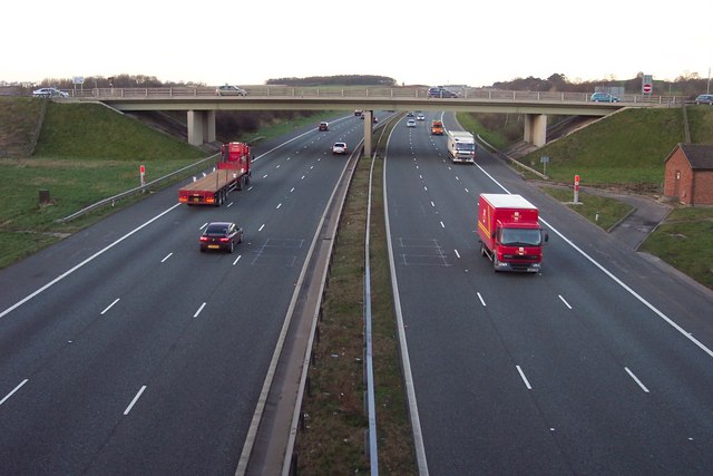
![A168 at Allerton Park The A168 runs parallel with the A1[M] at this point, using the south bound carriageway of the old A1. The wall to the right is the boundary of Allerton Park.](https://s2.geograph.org.uk/geophotos/01/06/31/1063142_0f4233fc.jpg)


Balfe Hill is located at Grid Ref: SE3857 (Lat: 54.012276, Lng: -1.4086486)
Division: West Riding
Administrative County: North Yorkshire
District: Harrogate
Police Authority: North Yorkshire
What 3 Words
///manhole.node.alien. Near Knaresborough, North Yorkshire
Nearby Locations
Related Wikis
Goldsborough railway station
Goldsborough railway station served the village of Goldsborough, North Yorkshire, England from 1850 to 1965 on the Harrogate line. The station was over...

Coneythorpe
Coneythorpe is a village in the civil parish of Coneythorpe and Clareton, in North Yorkshire, England. It is situated less than 1 mile (1.6 km) west from...

Flaxby
Flaxby is a village and civil parish in the Harrogate district of North Yorkshire, England. It is close to the A1(M) motorway and 2 miles (3.2 km) east...

Goldsborough, Harrogate
Goldsborough is a village and civil parish in North Yorkshire, England. It is situated near the River Nidd and one mile (1.6 km) east of Knaresborough...
Related Videos

Allerton Castle Virtual Viewing
Come and explore your dream wedding venue from the comfort of your own home. Congratulations on your engagement!

DJ Kev Williams For Something Amazing
There's weddings & there's DJ Kev Williams Weddings. Want more than a party? Want something extra special for your venue?

4k incredible cinematic wedding at a British Castle
GB Olympian, award winning venue @allertoncastle9051 award winning photographer @sansomphotography3431 suits by ...
Nearby Amenities
Located within 500m of 54.012276,-1.4086486Have you been to Balfe Hill?
Leave your review of Balfe Hill below (or comments, questions and feedback).