Barlings

Settlement in Lincolnshire West Lindsey

England

Barlings

St. Edward's church Grade II* listed parish church at Barlings
St. Edward's church Credit: Richard Croft

Barlings is a small village located in the county of Lincolnshire, England. Nestled in the East Midlands region, it is situated about 8 miles east of the city of Lincoln. With a population of around 400 residents, Barlings is known for its picturesque countryside and tranquil environment.

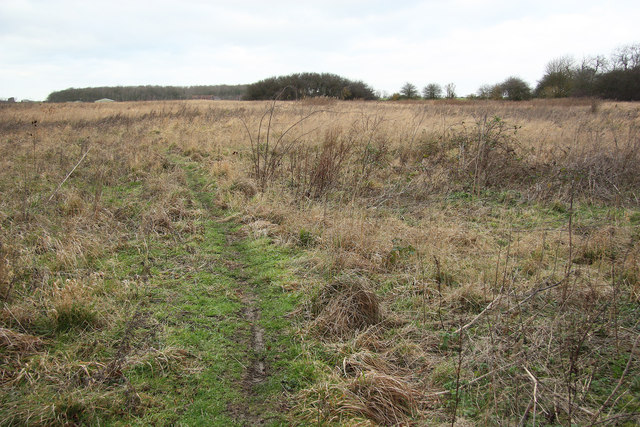
The village is surrounded by rolling hills, lush green meadows, and charming farmlands. It is bordered by the River Witham, which adds to the scenic beauty of the area. Barlings is a popular destination for nature enthusiasts, offering plenty of opportunities for hiking, cycling, and birdwatching.

The history of Barlings dates back to the Roman times, with several archaeological findings suggesting its ancient origins. The village boasts a rich heritage, including the ruins of the 12th-century St. Edward's Church, which adds a touch of historical charm to the area.

Despite its small size, Barlings has a strong community spirit and is home to a local pub, the Barlings Eau. The pub serves as a social hub for residents and visitors alike, offering a warm and friendly atmosphere.

While Barlings may be a quiet village, it benefits from its proximity to Lincoln, a vibrant city that offers a wide range of amenities and attractions. Residents of Barlings can easily access the city's shopping centers, restaurants, and cultural landmarks.

Overall, Barlings is a peaceful and idyllic village that provides a perfect escape from the hustle and bustle of city life, offering a serene and charming countryside setting.

If you have any feedback on the listing, please let us know in the comments section below.

Barlings Images

Images are sourced within 2km of 53.258639/-0.38999145 or Grid Reference TF0774. Thanks to Geograph Open Source API. All images are credited.

St. Edward's church Grade II* listed parish church at Barlings
St. Edward's church
Grade II* listed parish church at Barlings
St. Edward's church Grade II* listed parish church at Barlings
St. Edward's church
Grade II* listed parish church at Barlings
St. Edward's church nave View east towards the chancel
St. Edward's church nave
View east towards the chancel
St. Edward's church nave View west in St. Edward's church nave
St. Edward's church nave
View west in St. Edward's church nave
Barlings Abbey ruins The last remaining fragment of the Praemonstratensian Abbey founded 1154, surrounded by extensive earthworks, fishponds and smaller stone fragments. Grade I listed scheduled monument.
Barlings Abbey ruins
The last remaining fragment of the Praemonstratensian Abbey founded 1154, surrounded by extensive earthworks, fishponds and smaller stone fragments. Grade I listed scheduled monument.
Barlings grotesque A 14th century label stop for a vault springer in the ruins of Barlings Abbey <a title="https://www.geograph.org.uk/photo/7001830" href="https://www.geograph.org.uk/photo/7001830">Link</a>
Barlings grotesque
A 14th century label stop for a vault springer in the ruins of Barlings Abbey Link
Barlings Priory Site: aerial 2021 (2) See: <span class="nowrap"><a title="https://www.heritagegateway.org.uk/Gateway/Results_Single.aspx?uid=MLI54215&resourceID=1006" rel="nofollow ugc noopener" href="https://www.heritagegateway.org.uk/Gateway/Results_Single.aspx?uid=MLI54215&resourceID=1006">Link</a><img style="margin-left:2px;" alt="External link" title="External link - shift click to open in new window" src="https://s1.geograph.org.uk/img/external.png" width="10" height="10"/></span> and (upstanding remains): <span class="nowrap"><a title="https://www.heritagegateway.org.uk/Gateway/Results_Single.aspx?uid=MLI96528&resourceID=1006" rel="nofollow ugc noopener" href="https://www.heritagegateway.org.uk/Gateway/Results_Single.aspx?uid=MLI96528&resourceID=1006">Link</a><img style="margin-left:2px;" alt="External link" title="External link - shift click to open in new window" src="https://s1.geograph.org.uk/img/external.png" width="10" height="10"/></span>

Premonstratensian house founded 1154. Only part standing above ground is the NW pier of the crossing with a short length of wall between the nave and the N transept. This has nice c13 detail. The remainder of the site is unencumbered, being rough pasture, and it is possible that the whole ground could be recovered. No record can be found of any excavation.

Large area of earthworks and the NW pier and a short length of wall still standing; decoration on the wall is very similar to that in Southwell Minster chapter house. Other pieces of medieval masonry can be seen reused in the walls of the nearby cottage and its out-buildings.
Barlings Priory Site: aerial 2021 (2)
See: LinkExternal link and (upstanding remains): LinkExternal link Premonstratensian house founded 1154. Only part standing above ground is the NW pier of the crossing with a short length of wall between the nave and the N transept. This has nice c13 detail. The remainder of the site is unencumbered, being rough pasture, and it is possible that the whole ground could be recovered. No record can be found of any excavation. Large area of earthworks and the NW pier and a short length of wall still standing; decoration on the wall is very similar to that in Southwell Minster chapter house. Other pieces of medieval masonry can be seen reused in the walls of the nearby cottage and its out-buildings.
Barlings Priory Site: aerial 2021 (4) See: <span class="nowrap"><a title="https://www.heritagegateway.org.uk/Gateway/Results_Single.aspx?uid=MLI54215&resourceID=1006" rel="nofollow ugc noopener" href="https://www.heritagegateway.org.uk/Gateway/Results_Single.aspx?uid=MLI54215&resourceID=1006">Link</a><img style="margin-left:2px;" alt="External link" title="External link - shift click to open in new window" src="https://s1.geograph.org.uk/img/external.png" width="10" height="10"/></span> and (upstanding remains): <span class="nowrap"><a title="https://www.heritagegateway.org.uk/Gateway/Results_Single.aspx?uid=MLI96528&resourceID=1006" rel="nofollow ugc noopener" href="https://www.heritagegateway.org.uk/Gateway/Results_Single.aspx?uid=MLI96528&resourceID=1006">Link</a><img style="margin-left:2px;" alt="External link" title="External link - shift click to open in new window" src="https://s1.geograph.org.uk/img/external.png" width="10" height="10"/></span>

Premonstratensian house founded 1154. Only part standing above ground is the NW pier of the crossing with a short length of wall between the nave and the N transept. This has nice c13 detail. The remainder of the site is unencumbered, being rough pasture, and it is possible that the whole ground could be recovered. No record can be found of any excavation.

Large area of earthworks and the NW pier and a short length of wall still standing; decoration on the wall is very similar to that in Southwell Minster chapter house. Other pieces of medieval masonry can be seen reused in the walls of the nearby cottage and its out-buildings.
Barlings Priory Site: aerial 2021 (4)
See: LinkExternal link and (upstanding remains): LinkExternal link Premonstratensian house founded 1154. Only part standing above ground is the NW pier of the crossing with a short length of wall between the nave and the N transept. This has nice c13 detail. The remainder of the site is unencumbered, being rough pasture, and it is possible that the whole ground could be recovered. No record can be found of any excavation. Large area of earthworks and the NW pier and a short length of wall still standing; decoration on the wall is very similar to that in Southwell Minster chapter house. Other pieces of medieval masonry can be seen reused in the walls of the nearby cottage and its out-buildings.
Barlings Priory Site: aerial 2021 (4) with Barlings village Barlings village in <a href="https://www.geograph.org.uk/gridref/TF0774">TF0774</a>.

See: <span class="nowrap"><a title="https://www.heritagegateway.org.uk/Gateway/Results_Single.aspx?uid=MLI54215&resourceID=1006" rel="nofollow ugc noopener" href="https://www.heritagegateway.org.uk/Gateway/Results_Single.aspx?uid=MLI54215&resourceID=1006">Link</a><img style="margin-left:2px;" alt="External link" title="External link - shift click to open in new window" src="https://s1.geograph.org.uk/img/external.png" width="10" height="10"/></span> and (upstanding remains): <span class="nowrap"><a title="https://www.heritagegateway.org.uk/Gateway/Results_Single.aspx?uid=MLI96528&resourceID=1006" rel="nofollow ugc noopener" href="https://www.heritagegateway.org.uk/Gateway/Results_Single.aspx?uid=MLI96528&resourceID=1006">Link</a><img style="margin-left:2px;" alt="External link" title="External link - shift click to open in new window" src="https://s1.geograph.org.uk/img/external.png" width="10" height="10"/></span>

Premonstratensian house founded 1154. Only part standing above ground is the NW pier of the crossing with a short length of wall between the nave and the N transept. This has nice c13 detail. The remainder of the site is unencumbered, being rough pasture, and it is possible that the whole ground could be recovered. No record can be found of any excavation.

Large area of earthworks and the NW pier and a short length of wall still standing; decoration on the wall is very similar to that in Southwell Minster chapter house. Other pieces of medieval masonry can be seen reused in the walls of the nearby cottage and its out-buildings.

Cropmark in foreground could be part of the original foortprint of the Priory.
Barlings Priory Site: aerial 2021 (4) with Barlings village
Barlings village in TF0774. See: LinkExternal link and (upstanding remains): LinkExternal link Premonstratensian house founded 1154. Only part standing above ground is the NW pier of the crossing with a short length of wall between the nave and the N transept. This has nice c13 detail. The remainder of the site is unencumbered, being rough pasture, and it is possible that the whole ground could be recovered. No record can be found of any excavation. Large area of earthworks and the NW pier and a short length of wall still standing; decoration on the wall is very similar to that in Southwell Minster chapter house. Other pieces of medieval masonry can be seen reused in the walls of the nearby cottage and its out-buildings. Cropmark in foreground could be part of the original foortprint of the Priory.
Endeavour tropical house Tropical house at Woodside Wildlife Park. Formerly the Sir Joseph Banks Conservatory at The Lawn <a title="https://www.geograph.org.uk/photo/4372317" href="https://www.geograph.org.uk/photo/4372317">Link</a> <a title="https://www.geograph.org.uk/photo/5083761" href="https://www.geograph.org.uk/photo/5083761">Link</a> dismantled and relocated here in 2016-17.
Endeavour tropical house
Tropical house at Woodside Wildlife Park. Formerly the Sir Joseph Banks Conservatory at The Lawn Link Link dismantled and relocated here in 2016-17.
Tropical butterfly Exotic butterfly in the Endeavour tropical house at Woodside Wildlife Park
Tropical butterfly
Exotic butterfly in the Endeavour tropical house at Woodside Wildlife Park
Ring Tailed Lemur Friendly Lemur at Woodside Wildlife Park
Ring Tailed Lemur
Friendly Lemur at Woodside Wildlife Park
Asian Short-Clawed Otter Otter eating a shellfish at Woodside Wildlife Park
Asian Short-Clawed Otter
Otter eating a shellfish at Woodside Wildlife Park
St.Edward's church, Barlings, Lincs. A curious little church with a small Norman nave and Early English bellcote, then an odd chancel of 1876 in two parts, one higher than the other, giving this unusual appearance.
St.Edward's church, Barlings, Lincs.
A curious little church with a small Norman nave and Early English bellcote, then an odd chancel of 1876 in two parts, one higher than the other, giving this unusual appearance.
Barlings Abbey The last remaining fragment of the Praemonstratensian Abbey founded 1154, surrounded by extensive earthworks, fishponds and smaller stone fragments. many of the local houses have obviously been built with stone robbed from the ruins.
Barlings Abbey
The last remaining fragment of the Praemonstratensian Abbey founded 1154, surrounded by extensive earthworks, fishponds and smaller stone fragments. many of the local houses have obviously been built with stone robbed from the ruins.
Hardy Gang Wood There are two conflicting stories about the Hardy Gang. Either they were a group of 18th century vigilantes who captured and killed the 'wild man of Bardney' in this wood or a gang of outlaws whose hideout was here. Interestingly, the heraldic symbol of the Tyrwhitts of nearby Stainfield is a wild man !
Hardy Gang Wood
There are two conflicting stories about the Hardy Gang. Either they were a group of 18th century vigilantes who captured and killed the 'wild man of Bardney' in this wood or a gang of outlaws whose hideout was here. Interestingly, the heraldic symbol of the Tyrwhitts of nearby Stainfield is a wild man !
Footpath from Barlings Towards Hardy Gang Wood and Court House Farm
Footpath from Barlings
Towards Hardy Gang Wood and Court House Farm
Show me another place!

Barlings is located at Grid Ref: TF0774 (Lat: 53.258639, Lng: -0.38999145)

Division: Parts of Lindsey

Administrative County: Lincolnshire

District: West Lindsey

Police Authority: Lincolnshire

What 3 Words

///stops.tortoises.velocity. Near Sudbrooke, Lincolnshire

Nearby Locations

Barlings

Related Wikis

Barlings

Barlings and Low Barlings are two small hamlets lying south off the A158 road at Langworth, about 7 miles (11 km) east of Lincoln in the West Lindsey district...

Newball

Newball is a settlement and civil parish about 7 miles from Lincoln, in the West Lindsey district, in the county of Lincolnshire, England. In 2001 the...
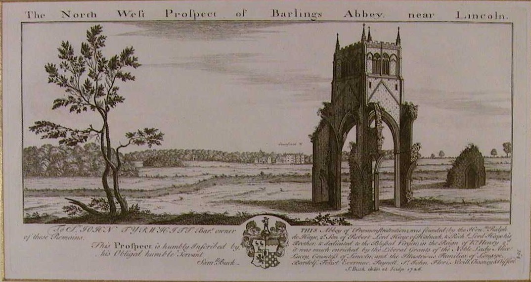
Barlings Abbey

Barlings Abbey was a one of nine Premonstratensian monasteries in the historical county of Lincolnshire, England. It was founded in 1154, as a daughter...

Langworth

Langworth is a small village in the West Lindsey district of Lincolnshire, England. It is situated 6 miles (10 km) north-east from the city and county...

Langworth railway station

Langworth railway station was a railway station in Langworth, Lincolnshire, opened in 1848 and closed in 1965. On 30 June 2015, a freight train was derailed...

RAF Fiskerton

Royal Air Force Fiskerton or more simply RAF Fiskerton was a Royal Air Force station located north of the Lincolnshire village of Fiskerton, 5.0 miles...

Bullington Priory

Bullington Priory was a priory in Bullington, Lincolnshire, England. The priory was a house of the Gilbertine Order and dedicated to Saint Mary. It was...

Stainton by Langworth

Stainton by Langworth is a hamlet and civil parish in the West Lindsey district of Lincolnshire, England. It is situated less than 1 mile (1.6 km) north...

Nearby Amenities

Located within 500m of 53.258639,-0.38999145
Barlings
Is In: Lincolnshire, England, UK
Place: hamlet
Source: Bing
Lat/Long: 53.2589977/-0.3896461
Barlings Abbey
Alt Name: Abbey of Barlings
Historic: monastery
Historic Amenity: place_of_worship
Note: Origional site of the abbey before moving just south to present site
Source: Bing
Lat/Long: 53.2591896/-0.3895624
Abbey House Farm
Place: farm
Source: Bing
Lat/Long: 53.2587042/-0.385516
Grange Farm
Place: farm
Source: Bing
Lat/Long: 53.260316/-0.3906156
Power: pole
Lat/Long: 53.2565899/-0.3946759
Power: pole
Lat/Long: 53.2567398/-0.3923696
Power: pole
Lat/Long: 53.2568532/-0.3904744
Power: pole
Lat/Long: 53.2569109/-0.3890642
Power: pole
Lat/Long: 53.2569896/-0.3877087
Power: pole
Lat/Long: 53.2570587/-0.3860753
Power: pole
Lat/Long: 53.2571667/-0.384303
Power: pole
Lat/Long: 53.2546076/-0.3925922
Power: pole
Lat/Long: 53.2552284/-0.3910256
Power: pole
Lat/Long: 53.2559817/-0.3891427
Power: pole
Lat/Long: 53.2561726/-0.3879038
Power: pole
Lat/Long: 53.2563273/-0.3868747
Power: pole
Lat/Long: 53.256543/-0.3854885
Power: pole
Lat/Long: 53.2581211/-0.3849433
Power: pole
Lat/Long: 53.2586868/-0.3832128
The data included in this document is from www.openstreetmap.org. The data is made available under ODbL.

Have you been to Barlings?

Leave your review of Barlings below (or comments, questions and feedback).