Carr Head

Hill, Mountain in Derbyshire Derbyshire Dales

England

Carr Head

Stanage Edge Stanage Edge above the path to Hook's Car parking
Stanage Edge Credit: Shaun Ferguson

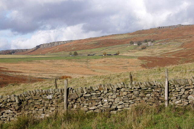
Carr Head is a prominent hill located in the county of Derbyshire, England. Situated in the Peak District National Park, it forms part of the Pennine range and offers stunning panoramic views of the surrounding countryside. Although referred to as a hill, Carr Head is often classified as a mountain due to its height and challenging terrain.

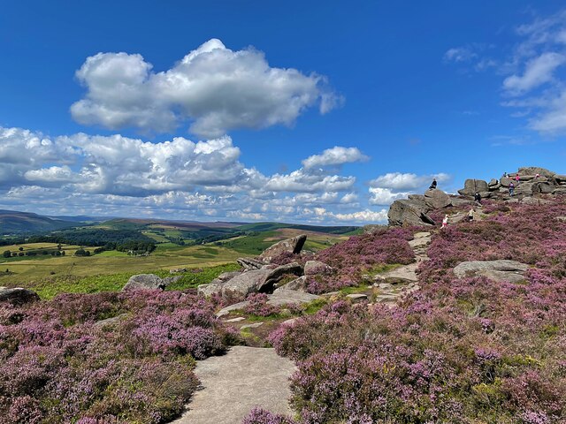
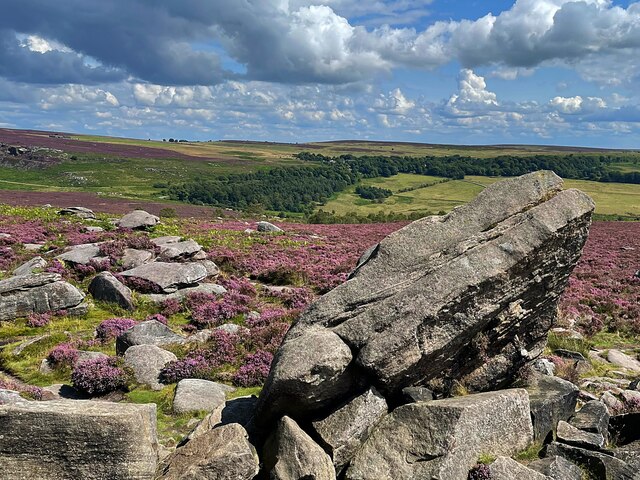
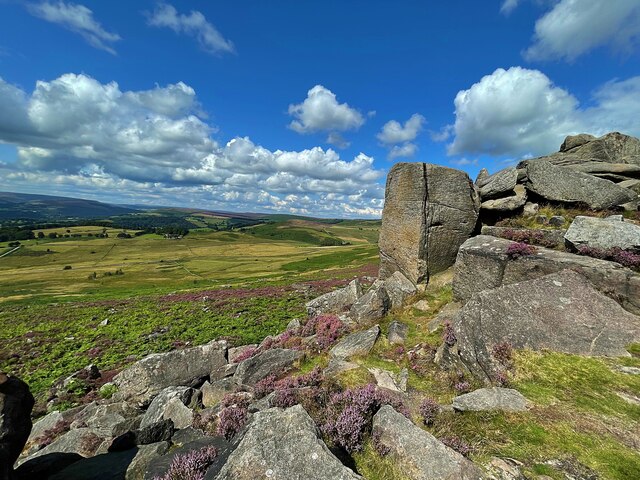
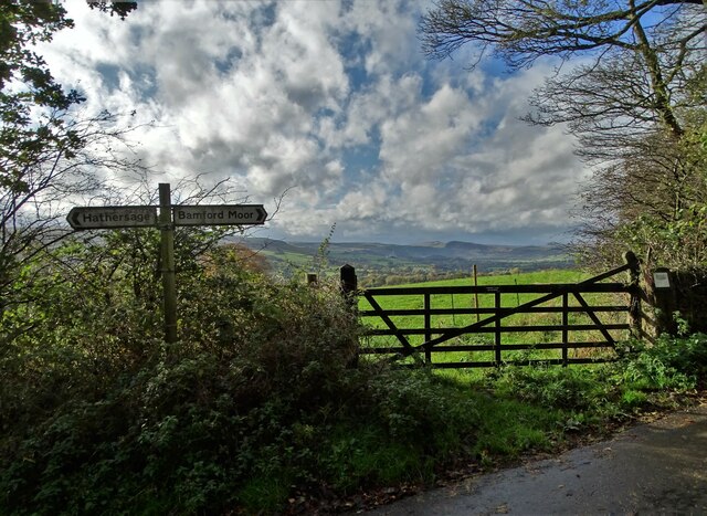
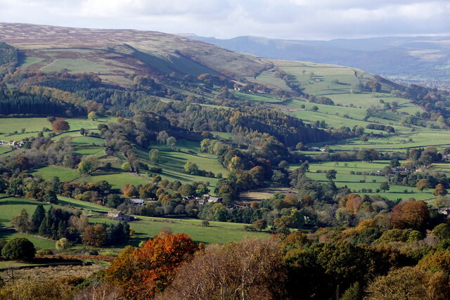
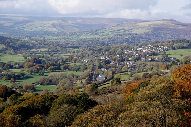
Standing at an elevation of approximately 472 meters (1,549 feet), Carr Head is a popular destination for hikers, climbers, and nature enthusiasts. It is accessible via several footpaths and trails, allowing visitors to explore its diverse landscapes, including moorland, woodland, and rocky outcrops. The hill's slopes are adorned with a variety of flora and fauna, making it a haven for wildlife.

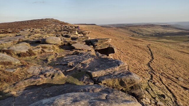
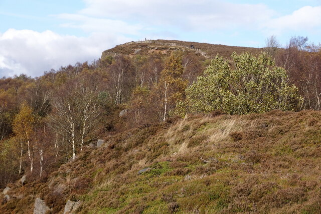
One of the notable features of Carr Head is its distinctive gritstone outcrops, which provide excellent opportunities for rock climbing and bouldering. The hill's rugged terrain and steep ascents present a challenge for climbers, attracting experienced adventurers seeking an adrenaline-fueled experience.

The summit of Carr Head offers breathtaking vistas, with views extending across the surrounding countryside, including the neighboring Edale Valley and Kinder Scout. On clear days, it is possible to see as far as the city of Manchester and the Cheshire Plain.

Carr Head is a place of natural beauty and tranquility, offering visitors the chance to immerse themselves in the stunning landscapes and rugged wilderness of the Peak District. Whether it's a leisurely hike, an adrenaline-filled climb, or simply enjoying the peace and serenity of nature, Carr Head has something to offer for everyone.

If you have any feedback on the listing, please let us know in the comments section below.

Carr Head Images

Images are sourced within 2km of 53.336604/-1.6368682 or Grid Reference SK2482. Thanks to Geograph Open Source API. All images are credited.

Stanage Edge Stanage Edge above the path to Hook's Car parking
Stanage Edge
Stanage Edge above the path to Hook's Car parking
On Hathersage Moor Looking north west from the footpath below Over Owler Tor
On Hathersage Moor
Looking north west from the footpath below Over Owler Tor
On Hathersage Moor Looking south east from Over Owler Tor
On Hathersage Moor
Looking south east from Over Owler Tor
On Hathersage Moor Looking north west from Over Owler Tor
On Hathersage Moor
Looking north west from Over Owler Tor
At the junction of Birley Lane and Coggers Lane Looking towards Hope Cement Works in The Hope Valley.
At the junction of Birley Lane and Coggers Lane
Looking towards Hope Cement Works in The Hope Valley.
Derwent Valley from Surprise View, Millstone Edge
Hathersage, from Surprise View, Millstone Edge
Millstone Edge, near Hathersage
Over Owler Tor, Millstone Edge
Mother Cap, Millstone Edge
Over Owler Tor from the north
Mitchell Field and Callow, near Hathersage
Higger Tor
Higger Tor
Burbage Rocks from Fiddler's Elbow
View to Friar's Ridge from Upper Burbage Bridge
Hathersage, Cloggers Lane This map reference, according to the OS benchmark database, is the location of a gatepost with a cutmark. Today the field wall has been rebuilt and a new bench seat positioned with a splendid view down the valley. The seat is built on 2 stone supporting blocks. Is this horizontal cut to the rear of the block the remnants of the cutmark?
Hathersage, Cloggers Lane
This map reference, according to the OS benchmark database, is the location of a gatepost with a cutmark. Today the field wall has been rebuilt and a new bench seat positioned with a splendid view down the valley. The seat is built on 2 stone supporting blocks. Is this horizontal cut to the rear of the block the remnants of the cutmark?
Hathersage, Coggers Lane This map reference, according to the OS benchmark database, is the location of a gatepost with a cutmark. Today the field wall has been rebuilt and a new bench seat positioned with a splendid view down the valley. The seat is built on 2 stone supporting blocks. Are the blocks the remnants of the old gateposts?
Hathersage, Coggers Lane
This map reference, according to the OS benchmark database, is the location of a gatepost with a cutmark. Today the field wall has been rebuilt and a new bench seat positioned with a splendid view down the valley. The seat is built on 2 stone supporting blocks. Are the blocks the remnants of the old gateposts?
A view of Over Owler Tor From the path to Winyard's Nick
A view of Over Owler Tor
From the path to Winyard's Nick
Show me another place!

Carr Head is located at Grid Ref: SK2482 (Lat: 53.336604, Lng: -1.6368682)

Administrative County: Derbyshire

District: Derbyshire Dales

Police Authority: Derbyshire

What 3 Words

///heap.gossip.worked. Near Hathersage, Derbyshire

Nearby Locations

Carr Head Carhead Rocks

Related Wikis

St Michael and All Angels' Church, Hathersage

St Michael and All Angels’ Church, Hathersage, is a Grade I listed parish church in the Church of England in Hathersage, Derbyshire. == History == The...

Stanage Edge

Stanage Edge, or simply Stanage (from "stone edge") is a gritstone escarpment in the Peak District, England, famous as a location for climbing. It lies...

Hood Brook

Hood Brook is a stream in the Derbyshire Peak District, originating near Stanage Edge, close to Robin Hoods Cave. == Background == Hood Brook flows south...

Higger Tor

Higger Tor or Higgar Tor is a gritstone tor in the Dark Peak, in the north of the Peak District National Park in England. It overlooks the Burbage Valley...

Hathersage railway station

Hathersage railway station serves the village of Hathersage in the Derbyshire Peak District, in England. == History == The station was opened on 25 June...

Hathersage

Hathersage ( HATHə-sidge) is a village and civil parish in the Peak District in Derbyshire, England. It lies slightly to the north of the River Derwent...

Carl Wark

Carl Wark (sometimes Carl's Wark) is a rocky promontory on Hathersage Moor in the Peak District National Park, just inside the boundary of Sheffield, England...

Master's Edge

Master's Edge is an 18-metre (59 ft) gritstone arête that is a rock climbing route in the "Corners Area" of Millstone Edge quarry, in the Peak District...

Nearby Amenities

Located within 500m of 53.336604,-1.6368682
Barrier: stile
Material: wood
Step Count: 1
Stile: stepover
Lat/Long: 53.3345414/-1.6432836
Barrier: stile
Material: stone
Source: survey;gps
Stile: stepover
Lat/Long: 53.3368461/-1.6417713
Barrier: stile
Source: survey;gps
Stile: stepover
Lat/Long: 53.3376382/-1.6436838
Barrier: stile
Source: survey;gps
Stile: squeezer
Lat/Long: 53.3381542/-1.6437116
Marker: aerial
Lat/Long: 53.3368713/-1.6417399
Marker: aerial
Lat/Long: 53.3369786/-1.6381283
Barrier: stile
Lat/Long: 53.3379716/-1.6382071
Barrier: stile
Stile: squeezer
Lat/Long: 53.3385377/-1.6435184
Barrier: cattle_grid
Lat/Long: 53.3375199/-1.6337236
The data included in this document is from www.openstreetmap.org. The data is made available under ODbL.

Have you been to Carr Head?

Leave your review of Carr Head below (or comments, questions and feedback).