Crow Hill

Hill, Mountain in Hampshire New Forest

England

Crow Hill

Crow Arch This bridge, known as 'Crow Arch' on the old LSWR 'Castleman's Corkscrew' line near Ringwood is approached by a steeply sloping road on either side - not for the faint-hearted when riding a bike!  Immediately past the bridge, the railway entered Ringwood Goods Yard before reaching the station.
Crow Arch Credit: Bob Walters

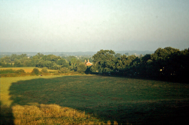
Crow Hill is a prominent hill located in the county of Hampshire, England. Situated near the village of Lyndhurst, it is part of the picturesque New Forest National Park. The hill is known for its distinctive crow-like shape, which has earned it the name "Crow Hill."

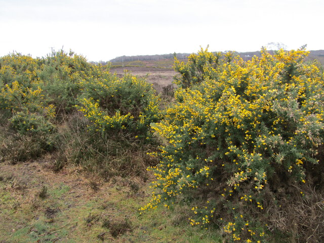
Standing at an elevation of approximately 151 meters (495 feet), Crow Hill offers breathtaking panoramic views of the surrounding countryside. Its location within the New Forest provides visitors with a unique blend of natural beauty and rich history. The hill is covered in a dense mix of heather, gorse, and grass, which adds to its scenic appeal.

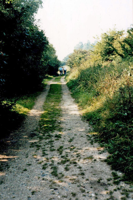
Crow Hill has become a popular destination for outdoor enthusiasts and nature lovers alike. Its well-maintained footpaths and trails attract hikers, walkers, and cyclists who wish to explore the rolling landscapes and enjoy the fresh air. The hill also offers opportunities for wildlife spotting, with various bird species, deer, and other small animals inhabiting the area.

Additionally, Crow Hill is steeped in history. It is said to have been the site of a pagan burial ground, and ancient artifacts have been discovered in the vicinity. The hill's connection to local folklore and legends adds an element of intrigue for those interested in the area's cultural heritage.

Overall, Crow Hill in Hampshire is a natural landmark that combines stunning views, outdoor activities, and a touch of history. Whether visitors are seeking a peaceful stroll or a challenging hike, this hill provides a serene escape in the heart of the New Forest National Park.

If you have any feedback on the listing, please let us know in the comments section below.

Crow Hill Images

Images are sourced within 2km of 50.832089/-1.7540115 or Grid Reference SU1703. Thanks to Geograph Open Source API. All images are credited.

Crow Arch This bridge, known as 'Crow Arch' on the old LSWR 'Castleman's Corkscrew' line near Ringwood is approached by a steeply sloping road on either side - not for the faint-hearted when riding a bike!  Immediately past the bridge, the railway entered Ringwood Goods Yard before reaching the station.
Crow Arch
This bridge, known as 'Crow Arch' on the old LSWR 'Castleman's Corkscrew' line near Ringwood is approached by a steeply sloping road on either side - not for the faint-hearted when riding a bike! Immediately past the bridge, the railway entered Ringwood Goods Yard before reaching the station.
View from Charles Copse over Crow The house in the centre of the picture is the photographer's boyhood home, in Barrack Lane.  The bushes in the left centre are where the railway line from Brockenhurst to Ringwood passed.  Behind the trees in the centre is the site of No. 14 Crossing, the keeper's cottage now a pleasant bungalow.
View from Charles Copse over Crow
The house in the centre of the picture is the photographer's boyhood home, in Barrack Lane. The bushes in the left centre are where the railway line from Brockenhurst to Ringwood passed. Behind the trees in the centre is the site of No. 14 Crossing, the keeper's cottage now a pleasant bungalow.
Old railway bridge at Bagnum The abutments of the old railway underbridge at Bagnum still exist but the steel deck was removed when the track was dismantled in the 1960's.  Charles Lane passes through on its way to Charles Farm at the top of the hill and onwards towards Burley.
Old railway bridge at Bagnum
The abutments of the old railway underbridge at Bagnum still exist but the steel deck was removed when the track was dismantled in the 1960's. Charles Lane passes through on its way to Charles Farm at the top of the hill and onwards towards Burley.
Houses on Hightown Road
Hightown Road
Hightown Road
Edward VII postbox on Eastfield Lane Postbox No. BH24 23.
Edward VII postbox on Eastfield Lane
Postbox No. BH24 23.
Old railway line Walking along the old 'Castleman's Corkscrew' railway line between level crossing No's 15 and 16.  This used to be the main line between Southampton and Weymouth before the Brockenhurst to Bournemouth diversion was built.  It became a backwater and was closed and dismantled in 1964.
Old railway line
Walking along the old 'Castleman's Corkscrew' railway line between level crossing No's 15 and 16. This used to be the main line between Southampton and Weymouth before the Brockenhurst to Bournemouth diversion was built. It became a backwater and was closed and dismantled in 1964.
Vales Moor - Heathland Gorse and heather abound in the New Forest by the Smugglers Road car park.
<span class="nowrap"><a title="www.newforesrnpa.gov.uk" rel="nofollow ugc noopener" href="http://www.newforesrnpa.gov.uk">Link</a><img style="margin-left:2px;" alt="External link" title="External link - shift click to open in new window" src="https://s1.geograph.org.uk/img/external.png" width="10" height="10"/></span>
Vales Moor - Heathland
Gorse and heather abound in the New Forest by the Smugglers Road car park. LinkExternal link
Track on Hightown Common
Path at Foulford
Path at Foulford
Path around properties at Foulford
The Elm Tree public house
Bend in Hightown Hill
Sandford Ford This is the first of two fords at Sandford.
Sandford Ford
This is the first of two fords at Sandford.
Ford at Sandford This is the second ford at Sandford.
Ford at Sandford
This is the second ford at Sandford.
Former level crossing in Barrack Lane Complete with some lengths of railway track.
Former level crossing in Barrack Lane
Complete with some lengths of railway track.
Former level crossing in Barrack Lane The railway track crossed immediately in front of the white house.
Former level crossing in Barrack Lane
The railway track crossed immediately in front of the white house.
Path on former railway trackbed south of Crow
Show me another place!

Crow Hill is located at Grid Ref: SU1703 (Lat: 50.832089, Lng: -1.7540115)

Administrative County: Hampshire

District: New Forest

Police Authority: Hampshire

What 3 Words

///driveways.ambitions.clearcut. Near Ringwood, Hampshire

Related Wikis

Crow, Hampshire

Crow is a small village situated in the New Forest National Park in Hampshire, England. Its nearest town is Ringwood, which lies approximately 1 mile...

Bagnum

Bagnum is a hamlet in the English county of Hampshire. The settlement is within the civil parish of Ringwood (where the 2011 Census was included), and...

Hightown, Hampshire

Hightown is a village in the New Forest district of Hampshire, England. Its nearest town is Ringwood, which lies approximately 0.8 miles (1.3 km) north...

Ringwood Town F.C.

Ringwood Town F.C. is a football club based in Ringwood, Hampshire, England. The club is affiliated to the Hampshire Football Association, and is a FA...

Poulner

Poulner (/'paʊnə/) is a small village in the civil parish of Ringwood in the New Forest district, in Hampshire, England, although its northern fringe lies...

Sandford, Hampshire

Sandford is a small hamlet in the New Forest National Park of Hampshire, England. The nearest town to Sandford is Ringwood, which is approximately 2.6...

Picket Hill

Picket Hill is a hamlet next to Picket Post in the New Forest National Park of Hampshire, England. It lies on the outskirts of Ringwood.

Forest Corner

Forest Corner is a village in the New Forest National Park of Hampshire, England. It is on the A31 road travelling between Southampton and Bournemouth...

Nearby Amenities

Located within 500m of 50.832089,-1.7540115
Power: pole
Source: bing
Lat/Long: 50.8345057/-1.7580043
Power: pole
Source: bing
Lat/Long: 50.8330582/-1.7604102
Power: pole
Source: bing
Lat/Long: 50.8336308/-1.7585702
Power: pole
Source: bing
Lat/Long: 50.833757/-1.7574665
Power: pole
Source: bing
Lat/Long: 50.8338798/-1.7563641
Power: pole
Source: bing
Lat/Long: 50.8303392/-1.7535076
Power: pole
Source: bing
Lat/Long: 50.831088/-1.7530087
Power: pole
Source: bing
Lat/Long: 50.831841/-1.7524843
Power: pole
Source: bing
Lat/Long: 50.8324932/-1.7520203
Power: pole
Source: bing
Lat/Long: 50.8331268/-1.751575
Power: pole
Source: bing
Lat/Long: 50.8338578/-1.7530368
Power: pole
Source: bing
Lat/Long: 50.8339831/-1.755259
Power: pole
Source: bing
Lat/Long: 50.8341212/-1.7541929
Power: pole
Source: bing
Lat/Long: 50.8342491/-1.7530905
Power: pole
Source: bing
Lat/Long: 50.8347708/-1.7521745
Power: pole
Source: bing
Lat/Long: 50.8357779/-1.750364
Power: pole
Source: bing
Lat/Long: 50.8352629/-1.7512599
The data included in this document is from www.openstreetmap.org. The data is made available under ODbL.

Have you been to Crow Hill?

Leave your review of Crow Hill below (or comments, questions and feedback).