Bell's Hill

Hill, Mountain in Northumberland

England

Bell's Hill

Road to Longhorsley
Road to Longhorsley Credit: David Dixon

Bell's Hill is a prominent hill located in the county of Northumberland, England. Situated in the northern part of the county, it forms part of the scenic landscape of the North Pennines Area of Outstanding Natural Beauty. The hill is known for its distinctive shape and commanding views, making it a popular destination for outdoor enthusiasts and nature lovers.

Rising to an elevation of approximately 400 meters (1,312 feet), Bell's Hill stands tall amidst the undulating countryside. Its summit provides breathtaking panoramic vistas of the surrounding area, including the picturesque valleys, rolling hills, and charming villages that dot the landscape. On a clear day, it is said that one can even catch a glimpse of the distant North Sea.

The hill itself is characterized by its rugged terrain, with steep slopes covered in heather and grasses. It is home to a variety of flora and fauna, including wildflowers, birds, and insects. The area is also rich in archaeological remains, with traces of ancient settlements and stone circles found in its vicinity.

Access to Bell's Hill is relatively easy, with several footpaths and trails leading to its summit. Hikers, walkers, and cyclists can explore the hill's natural beauty while enjoying the peace and tranquility of the Northumberland countryside. Its location also makes it a perfect spot for stargazing, with minimal light pollution offering clear views of the night sky.

Overall, Bell's Hill is a cherished natural landmark in Northumberland, providing locals and visitors alike with a chance to immerse themselves in the region's stunning scenery and rich history.

If you have any feedback on the listing, please let us know in the comments section below.

Bell's Hill Images

Images are sourced within 2km of 55.261593/-1.746956 or Grid Reference NZ1696. Thanks to Geograph Open Source API. All images are credited.

Road to Longhorsley
Road to Longhorsley
East Road, Longhorsley
South Linden A motorhome stop off site.
South Linden
A motorhome stop off site.
Wheat, East Linden
Wheat, East Linden
Striowood, Burgham Park 16 years on from <a href="https://www.geograph.org.uk/photo/438533">NZ1696 : Shelter belt</a>. Surrounds a golf course.
Striowood, Burgham Park
16 years on from NZ1696 : Shelter belt. Surrounds a golf course.
Ungrazed corner Near East Linden
Greenkeepers' Burgham A big housing development is being advertised near the golf course.
Greenkeepers' Burgham
A big housing development is being advertised near the golf course.
Road passing Burgham Golf course on the left.
Road passing Burgham
Golf course on the left.
Paxton Dene Auxiliary Unit Operational Base This is the almost closed escape tunnel exit from the subterranean Nissen hut that would have become the secret base for a local resistance unit in the event of a German invasion.  Listed on Keys To The Past

<span class="nowrap"><a title="https://keystothepast.info/search-records/results-of-search/results-of-search-2/site-details/?PRN=N24071" rel="nofollow ugc noopener" href="https://keystothepast.info/search-records/results-of-search/results-of-search-2/site-details/?PRN=N24071">Link</a><img style="margin-left:2px;" alt="External link" title="External link - shift click to open in new window" src="https://s1.geograph.org.uk/img/external.png" width="10" height="10"/></span>

<span class="nowrap"><a title="https://www.staybehinds.com/patrol/paxtondene-patrol" rel="nofollow ugc noopener" href="https://www.staybehinds.com/patrol/paxtondene-patrol">Link</a><img style="margin-left:2px;" alt="External link" title="External link - shift click to open in new window" src="https://s1.geograph.org.uk/img/external.png" width="10" height="10"/></span>
Paxton Dene Auxiliary Unit Operational Base
This is the almost closed escape tunnel exit from the subterranean Nissen hut that would have become the secret base for a local resistance unit in the event of a German invasion. Listed on Keys To The Past LinkExternal link LinkExternal link
Paxton Dene Auxiliary Unit Operational Base The rubbish strewn interior of the subterranean Nissen hut that would have become the secret base for a local resistance unit in the event of a German invasion.  Listed on Keys To The Past

<span class="nowrap"><a title="https://keystothepast.info/search-records/results-of-search/results-of-search-2/site-details/?PRN=N24071" rel="nofollow ugc noopener" href="https://keystothepast.info/search-records/results-of-search/results-of-search-2/site-details/?PRN=N24071">Link</a><img style="margin-left:2px;" alt="External link" title="External link - shift click to open in new window" src="https://s1.geograph.org.uk/img/external.png" width="10" height="10"/></span>

<span class="nowrap"><a title="https://www.staybehinds.com/patrol/paxtondene-patrol" rel="nofollow ugc noopener" href="https://www.staybehinds.com/patrol/paxtondene-patrol">Link</a><img style="margin-left:2px;" alt="External link" title="External link - shift click to open in new window" src="https://s1.geograph.org.uk/img/external.png" width="10" height="10"/></span>
Paxton Dene Auxiliary Unit Operational Base
The rubbish strewn interior of the subterranean Nissen hut that would have become the secret base for a local resistance unit in the event of a German invasion. Listed on Keys To The Past LinkExternal link LinkExternal link
Paxton Dene Auxiliary Unit Operational Base 15 years on from <a href="https://www.geograph.org.uk/photo/7651574">NZ1694 : Paxton Dene Auxiliary Unit Operational Base</a> the rear section of this WWII structure has collapsed, with what remains of the interior flooded.  The subterranean Nissen hut would have become the secret base for a local resistance unit in the event of a German invasion. Listed on Keys To The Past

<span class="nowrap"><a title="https://keystothepast.info/search-records/results-of-search/results-of-search-2/site-details/?PRN=N24071" rel="nofollow ugc noopener" href="https://keystothepast.info/search-records/results-of-search/results-of-search-2/site-details/?PRN=N24071">Link</a><img style="margin-left:2px;" alt="External link" title="External link - shift click to open in new window" src="https://s1.geograph.org.uk/img/external.png" width="10" height="10"/></span>

<span class="nowrap"><a title="https://www.staybehinds.com/patrol/paxtondene-patrol" rel="nofollow ugc noopener" href="https://www.staybehinds.com/patrol/paxtondene-patrol">Link</a><img style="margin-left:2px;" alt="External link" title="External link - shift click to open in new window" src="https://s1.geograph.org.uk/img/external.png" width="10" height="10"/></span>
Paxton Dene Auxiliary Unit Operational Base
15 years on from NZ1694 : Paxton Dene Auxiliary Unit Operational Base the rear section of this WWII structure has collapsed, with what remains of the interior flooded. The subterranean Nissen hut would have become the secret base for a local resistance unit in the event of a German invasion. Listed on Keys To The Past LinkExternal link LinkExternal link
Paxton Dene Auxiliary Unit Operational Base 15 years on from <a href="https://www.geograph.org.uk/photo/7651574">NZ1694 : Paxton Dene Auxiliary Unit Operational Base</a> the rear section of this WWII structure has collapsed, with what remains of the interior flooded.  80 years ago the subterranean Nissen hut would have become the secret base for a local resistance unit in the event of a German invasion. Listed on Keys To The Past

<span class="nowrap"><a title="https://keystothepast.info/search-records/results-of-search/results-of-search-2/site-details/?PRN=N24071" rel="nofollow ugc noopener" href="https://keystothepast.info/search-records/results-of-search/results-of-search-2/site-details/?PRN=N24071">Link</a><img style="margin-left:2px;" alt="External link" title="External link - shift click to open in new window" src="https://s1.geograph.org.uk/img/external.png" width="10" height="10"/></span>

<span class="nowrap"><a title="https://www.staybehinds.com/patrol/paxtondene-patrol" rel="nofollow ugc noopener" href="https://www.staybehinds.com/patrol/paxtondene-patrol">Link</a><img style="margin-left:2px;" alt="External link" title="External link - shift click to open in new window" src="https://s1.geograph.org.uk/img/external.png" width="10" height="10"/></span>
Paxton Dene Auxiliary Unit Operational Base
15 years on from NZ1694 : Paxton Dene Auxiliary Unit Operational Base the rear section of this WWII structure has collapsed, with what remains of the interior flooded. 80 years ago the subterranean Nissen hut would have become the secret base for a local resistance unit in the event of a German invasion. Listed on Keys To The Past LinkExternal link LinkExternal link
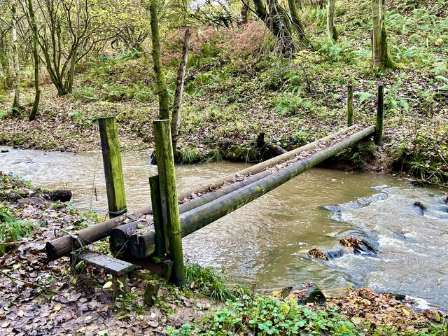
Bridge for the bold Across the Paxtondean Burn.  Wet and slippery; no handrail.
Bridge for the bold
Across the Paxtondean Burn. Wet and slippery; no handrail.
Linden Hall Hotel
Linden Hall Hotel
Strawberry picking
Strawberry picking
Ford and footbridge, Paxtondean Burn
Paxton Dene Farm
Paxton Dene Farm
Field at Highmoor From the entrance to South Highmoor farm beside the lane to Felton. The land gently slopes northeast towards the lower part of Coquet valley.
Field at Highmoor
From the entrance to South Highmoor farm beside the lane to Felton. The land gently slopes northeast towards the lower part of Coquet valley.
Show me another place!

Bell's Hill is located at Grid Ref: NZ1696 (Lat: 55.261593, Lng: -1.746956)

Unitary Authority: Northumberland

Police Authority: Northumbria

What 3 Words

///sobs.renamed.triangles. Near Longhorsley, Northumberland

Nearby Locations

Bell's Hill

Related Wikis

Linden Hall, Northumberland

Linden Hall is a former mansion house in the civil parish of Longhorsley, Northumberland, England which is now operated as a hotel and country club. This...

Causey Park House

Causey Park House is a 16th-century former manor house with Grade II listed building status situated at Causey Park, Northumberland, England. The Manors...

Longhorsley

Longhorsley is a village in Northumberland, England about 7 miles (11 km) northwest of Morpeth, and about 14 miles (23 km) south of Alnwick. The A697 road...

Eshott Airfield

Eshott Airfield is a former Royal Air Force (RAF) World War II airfield in the civil parish of Thirston, in the county of Northumberland, England, 20 miles...

Nearby Amenities

Located within 500m of 55.261593,-1.746956
Bell's Hill
Place: locality
Lat/Long: 55.2615529/-1.7476914
The data included in this document is from www.openstreetmap.org. The data is made available under ODbL.

Have you been to Bell's Hill?

Leave your review of Bell's Hill below (or comments, questions and feedback).