Sourmoor Hill

Hill, Mountain in Yorkshire Richmondshire

England

Sourmoor Hill

Stile near Downholme Bridge The stile gives walkers access to the footpath that takes them initially beside the River Swale before heading west towards Cat Bank and Marske.
Stile near Downholme Bridge Credit: Maigheach-gheal

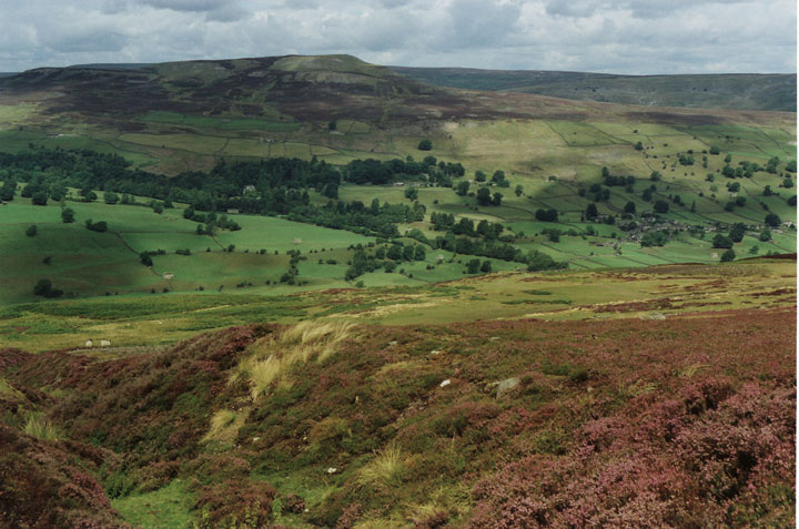
Sourmoor Hill is a prominent hill located in the county of Yorkshire, England. With an elevation of approximately 400 meters (1,312 feet), it is considered one of the higher peaks in the Yorkshire Dales National Park. Sourmoor Hill is situated near the village of Hawes, within the North Yorkshire district.

The hill is characterized by its rugged and undulating terrain, covered in a mixture of grasses, heather, and sparse vegetation. Its slopes are relatively steep, offering hikers and outdoor enthusiasts a challenging ascent. From the summit, visitors can enjoy breathtaking panoramic views of the surrounding countryside, including the vast expanse of the Yorkshire Dales.

Sourmoor Hill is a haven for wildlife, with various species of birds, mammals, and insects calling it home. The hillside vegetation supports a diverse range of flora, including wildflowers and mosses. It is not uncommon to spot grazing sheep or other livestock on the lower slopes, as farming is an integral part of the local economy.

The hill is a popular destination for outdoor activities such as hiking, hillwalking, and birdwatching. Its remote location and natural beauty make it an ideal spot for those seeking solitude and tranquility. However, it is important to note that appropriate clothing, footwear, and navigational skills are essential when exploring Sourmoor Hill, as the terrain can be challenging and weather conditions unpredictable.

Overall, Sourmoor Hill offers visitors a chance to immerse themselves in the stunning landscape of the Yorkshire Dales, providing both a physical challenge and a chance to appreciate the natural beauty of the region.

If you have any feedback on the listing, please let us know in the comments section below.

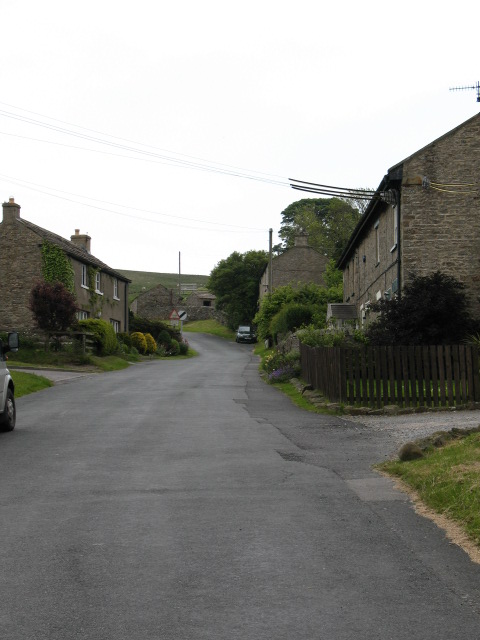
Sourmoor Hill Images

Images are sourced within 2km of 54.371203/-1.8206441 or Grid Reference SE1197. Thanks to Geograph Open Source API. All images are credited.

Stile near Downholme Bridge The stile gives walkers access to the footpath that takes them initially beside the River Swale before heading west towards Cat Bank and Marske.
Stile near Downholme Bridge
The stile gives walkers access to the footpath that takes them initially beside the River Swale before heading west towards Cat Bank and Marske.
Downholme Bridge Late 17th century, Grade II listed bridge.  It is built of rubble with ashlar dressings.
Downholme Bridge
Late 17th century, Grade II listed bridge. It is built of rubble with ashlar dressings.
River Swale, Downholme Looking upstream from Downholme Bridge.

The River Swale is the northernmost tributary of the Yorkshire Ouse with its headwaters located in the eastern Yorkshire Dales, from where it flows in an easterly direction towards Richmond.
River Swale, Downholme
Looking upstream from Downholme Bridge. The River Swale is the northernmost tributary of the Yorkshire Ouse with its headwaters located in the eastern Yorkshire Dales, from where it flows in an easterly direction towards Richmond.
River Swale, Downholme Looking downstream from Downholme Bridge.
 
The River Swale is the northernmost tributary of the Yorkshire Ouse with its headwaters located in the eastern Yorkshire Dales, from where it flows in an easterly direction towards Richmond.
River Swale, Downholme
Looking downstream from Downholme Bridge. The River Swale is the northernmost tributary of the Yorkshire Ouse with its headwaters located in the eastern Yorkshire Dales, from where it flows in an easterly direction towards Richmond.
A6108 near Downholme Church
View of Lower Swaledale The picture was taken close to a newly constructed viewing point on the road which crosses Ministry of Defence land on Downholme Moor.
View of Lower Swaledale
The picture was taken close to a newly constructed viewing point on the road which crosses Ministry of Defence land on Downholme Moor.
Downholme Village Minor roads entering the village from the A6108
Downholme Village
Minor roads entering the village from the A6108
A6108, Downholme village
Cattle Grid, Coldstorms Farm Track leading from A6108 Walburnhead to the farm.
Cattle Grid, Coldstorms Farm
Track leading from A6108 Walburnhead to the farm.
Walburnhead, A6108 Near track to Coldstorms Farm.
Walburnhead, A6108
Near track to Coldstorms Farm.
Boston Bridge Carries the A6108 over Black Beck. View from Boston Farm track. Notice the crows gathering.
Boston Bridge
Carries the A6108 over Black Beck. View from Boston Farm track. Notice the crows gathering.
Boston Beck A6108 crossing the beck near Boston Farm.
Boston Beck
A6108 crossing the beck near Boston Farm.
Walburn Hall Viewed from the junction of A6108 and minor road to Wathgill Camp.
Walburn Hall
Viewed from the junction of A6108 and minor road to Wathgill Camp.
Fields near Downholme View across sheep grazing land with Gill Beck on the immediate left leading to Swaledale.
Fields near Downholme
View across sheep grazing land with Gill Beck on the immediate left leading to Swaledale.
St. Michael and All Angels Church Near Downholme.
St. Michael and All Angels Church
Near Downholme.
Mole Hills near Downholme Side Bank Wood in the sun.
Mole Hills near Downholme
Side Bank Wood in the sun.
Approaching Downholme Bridge junction
Downholme church from A6108
Show me another place!

Sourmoor Hill is located at Grid Ref: SE1197 (Lat: 54.371203, Lng: -1.8206441)

Division: North Riding

Administrative County: North Yorkshire

District: Richmondshire

Police Authority: North Yorkshire

What 3 Words

///leaflet.regrowth.hidden. Near Catterick Garrison, North Yorkshire

Nearby Locations

Sourmoor Hill Downholme

Related Wikis

Downholme

Downholme is a village and civil parish in North Yorkshire, England. It is situated approximately 4 miles (6 km) west from the market town of Richmond...

Stainton, west North Yorkshire

Stainton is a hamlet and civil parish in the North Yorkshire district of North Yorkshire, England. It is located just outside the Yorkshire Dales National...

Walburn, North Yorkshire

Walburn is a hamlet and civil parish in North Yorkshire, England. It is located in lower Swaledale, 5 miles (8 km) south-west of Richmond. The population...

Swaledale

Swaledale is a valley in North Yorkshire, England. It is one of the Yorkshire Dales, which are part of the Pennines, and within the Yorkshire Dales National...

Nearby Amenities

Located within 500m of 54.371203,-1.8206441
Seat How
Ele: 311.2
Is In County: North Yorkshire
Is In Historic County: Yorkshire
Man Made: survey_point
Natural: peak
Source: NPE
Lat/Long: 54.373507/-1.8142309
Sourmoor Hill
Natural: peak
Source: OS 1:25k
Lat/Long: 54.3710976/-1.8207844
The data included in this document is from www.openstreetmap.org. The data is made available under ODbL.

Have you been to Sourmoor Hill?

Leave your review of Sourmoor Hill below (or comments, questions and feedback).