Cronkston Low

Hill, Mountain in Derbyshire Derbyshire Dales

England

Cronkston Low

Following the Lane to Earl Sterndale The lane in the deep shadows between the heights of High Wheeldon and Aldery Cliff.
Following the Lane to Earl Sterndale Credit: Chris Heaton

Cronkston Low, located in Derbyshire, England, is a prominent hill that offers breathtaking views and a tranquil escape for nature enthusiasts. With an elevation of approximately 225 meters (738 feet), it is not considered a mountain but rather a notable hill in the area. It is part of the Peak District National Park, which is renowned for its stunning landscapes and outdoor recreational activities.

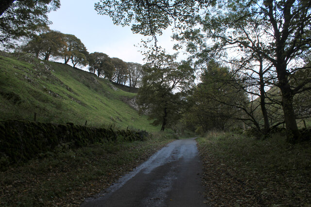
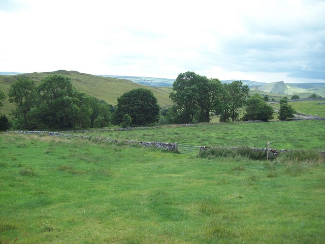
The hill is covered in lush greenery, including grasses, heather, and scattered trees, providing a picturesque backdrop for visitors. The terrain is relatively gentle, making it accessible for hikers of varying abilities. Numerous walking trails crisscross the area, allowing visitors to explore and appreciate the natural beauty from different vantage points.

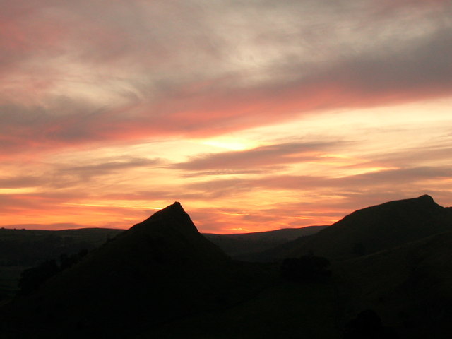
Reaching the summit of Cronkston Low rewards visitors with panoramic views of the surrounding countryside. On clear days, one can see the rolling hills, valleys, and picturesque villages that dot the landscape. The hill is particularly popular during sunrise and sunset, when the sky is bathed in vibrant hues, enhancing the overall experience.

Cronkston Low is also home to a diverse range of wildlife, including various bird species, small mammals, and insects. Birdwatchers can spot species such as buzzards, kestrels, and meadow pipits soaring through the skies above. The hill's natural habitat provides a sanctuary for these creatures and contributes to the overall biodiversity of the region.

Overall, Cronkston Low offers a peaceful retreat for those seeking to immerse themselves in nature and enjoy the stunning vistas that Derbyshire has to offer.

If you have any feedback on the listing, please let us know in the comments section below.

Cronkston Low Images

Images are sourced within 2km of 53.193829/-1.8260823 or Grid Reference SK1166. Thanks to Geograph Open Source API. All images are credited.

Following the Lane to Earl Sterndale The lane in the deep shadows between the heights of High Wheeldon and Aldery Cliff.
Following the Lane to Earl Sterndale
The lane in the deep shadows between the heights of High Wheeldon and Aldery Cliff.
Path around the foot of High Wheeldon
Fields below High Wheeldon
High Wheeldon from Green Lane
Lane below High Wheeldon
Start of a footpath above Earl Sterndale Climbing up to the lane that runs along the perimeter of Hindlow and Dowlow Quarries.
Start of a footpath above Earl Sterndale
Climbing up to the lane that runs along the perimeter of Hindlow and Dowlow Quarries.
Fox Hole Cave, Higher Wheeldon Cave situated on the steep north slope of High Wheeldon Hill consisting of a passage opening out into several chambers (Entrance, First and Main), and a second deeper series including the Bear Chamber. The entrance passage and upper chamber are the main areas of archaeological interest. The cave was excavated in 1928-29, and again between 1961 and 1981 revealing Palaeolithic, Mesolithic, Neolithic, Beaker, Bronze Age and Roman material. The cave was designated as a Scheduled Monument in 1991.

<span class="nowrap"><a title="https://heritagerecords.nationaltrust.org.uk/HBSMR/MonRecord.aspx?uid=MNA113195" rel="nofollow ugc noopener" href="https://heritagerecords.nationaltrust.org.uk/HBSMR/MonRecord.aspx?uid=MNA113195">Link</a><img style="margin-left:2px;" alt="External link" title="External link - shift click to open in new window" src="https://s1.geograph.org.uk/img/external.png" width="10" height="10"/></span>
Fox Hole Cave, Higher Wheeldon
Cave situated on the steep north slope of High Wheeldon Hill consisting of a passage opening out into several chambers (Entrance, First and Main), and a second deeper series including the Bear Chamber. The entrance passage and upper chamber are the main areas of archaeological interest. The cave was excavated in 1928-29, and again between 1961 and 1981 revealing Palaeolithic, Mesolithic, Neolithic, Beaker, Bronze Age and Roman material. The cave was designated as a Scheduled Monument in 1991. LinkExternal link
Footpath round side of High Wheeldon, near Earl Sterndale Access land owned by National Trust
Footpath round side of High Wheeldon, near Earl Sterndale
Access land owned by National Trust
Cattle grazing in the shadow of High Wheeldon View from lane between Earl Sterndale and Crowdecote.
Cattle grazing in the shadow of High Wheeldon
View from lane between Earl Sterndale and Crowdecote.
Trough and track to Braemar House A fan of Royal Deeside ?
Trough and track to Braemar House
A fan of Royal Deeside ?
Footpath near Alderley Cliff The spine of Chrome Hill (SK0767) is visible on the right horizon.
Footpath near Alderley Cliff
The spine of Chrome Hill (SK0767) is visible on the right horizon.
Fox Hole Cave High up on the west side of High Wheeldon, the cave was first occupied around 4000BC.
Fox Hole Cave
High up on the west side of High Wheeldon, the cave was first occupied around 4000BC.
Entry to Fox Hole Cave on Wheeldon Hill Sealed off by the National Trust to deter unauthorised entry. Archaeologists have excavated within the cave which may have been occupied by man as long ago as 4,000 BC. See; <span class="nowrap"><a title="http://capra.group.shef.ac.uk/3/foxholedates.html" rel="nofollow ugc noopener" href="http://capra.group.shef.ac.uk/3/foxholedates.html">Link</a><img style="margin-left:2px;" alt="External link" title="External link - shift click to open in new window" src="https://s1.geograph.org.uk/img/external.png" width="10" height="10"/></span>
Entry to Fox Hole Cave on Wheeldon Hill
Sealed off by the National Trust to deter unauthorised entry. Archaeologists have excavated within the cave which may have been occupied by man as long ago as 4,000 BC. See; LinkExternal link
High Wheeldon on a fiery backdrop The tip of High Wheeldon Looking across the trig point, south west from Wheeldon Trees.
High Wheeldon on a fiery backdrop
The tip of High Wheeldon Looking across the trig point, south west from Wheeldon Trees.
Old limestone barn on the slopes of Dowlow Above Braemar House
Old limestone barn on the slopes of Dowlow
Above Braemar House
Uphill past Green Lane Cottages
Morning fog on Aldery Cliff at Earl Sterndale & Brocken Spectre
Footpath up High Wheeldon
Show me another place!

Cronkston Low is located at Grid Ref: SK1166 (Lat: 53.193829, Lng: -1.8260823)

Administrative County: Derbyshire

District: Derbyshire Dales

Police Authority: Derbyshire

What 3 Words

///received.dwarves.brotherly. Near Newhaven, Derbyshire

Nearby Locations

Cronkston Low

Related Wikis

Hartington Middle Quarter

Hartington Middle Quarter is a civil parish within the Derbyshire Dales district, which is in the county of Derbyshire, England. Formerly a part of Hartington...

Hurdlow railway station

Hurdlow railway station was near to the hamlet of Hurdlow within Hartington Middle Quarter civil parish, to the south east of Buxton, Derbyshire on the...

High Wheeldon

High Wheeldon is a distinctive dome-shaped hill near the Staffordshire border in Hartington Middle Quarter civil parish, Derbyshire, in the Peak District...

Cromford and High Peak Railway

The Cromford and High Peak Railway (C&HPR) was a standard-gauge line between the Cromford Canal wharf at High Peak Junction and the Peak Forest Canal at...

Nearby Amenities

Located within 500m of 53.193829,-1.8260823
Barrier: stile
Material: stone
Source: survey;gps
Stile: stepover
Lat/Long: 53.1978439/-1.8261079
Barrier: stile
Material: stone
Source: survey;gps
Steps: 3
Stile: stepover
Lat/Long: 53.1971908/-1.8263696
Power: pole
Lat/Long: 53.1943771/-1.8229087
Power: pole
Lat/Long: 53.1957401/-1.8243205
Power: pole
Lat/Long: 53.193699/-1.8221791
Power: pole
Lat/Long: 53.1933326/-1.8210177
Power: pole
Lat/Long: 53.1950697/-1.823657
Power: pole
Lat/Long: 53.1928606/-1.8190472
Power: pole
Lat/Long: 53.1930293/-1.8200236
Power: pole
Lat/Long: 53.1964901/-1.8251403
Barrier: stile
Material: stone
Source: survey;gps
Stile: stepover
Lat/Long: 53.1911461/-1.8319317
Barrier: stile
Material: stone
Source: survey;gps
Stile: stepover
Lat/Long: 53.194167/-1.8310859
Barrier: entrance
Source: survey;gps
Lat/Long: 53.1953404/-1.8307428
Barrier: stile
Material: stone
Source: survey;gps
Stile: stepover
Lat/Long: 53.1957102/-1.8277958
Barrier: stile
Material: stone
Source: survey;gps
Stile: stepover
Lat/Long: 53.1971092/-1.826732
Tourism: picnic_site
Lat/Long: 53.1969869/-1.8263598
Leisure: picnic_table
Lat/Long: 53.196816/-1.8261786
Leisure: picnic_table
Lat/Long: 53.1968205/-1.826037
Cronkston Low Bowl Barrow
Archaeological Site: tumulus
Heritage: yes
Historic: archaeological_site
Wikidata: Q17670335
Lat/Long: 53.1937637/-1.8265575
Cronkston Low
Ele: 415
Natural: peak
Lat/Long: 53.1937624/-1.8267268
The data included in this document is from www.openstreetmap.org. The data is made available under ODbL.

Have you been to Cronkston Low?

Leave your review of Cronkston Low below (or comments, questions and feedback).