Cabin Hill

Hill, Mountain in Durham

England

Cabin Hill

The Lodge of St. John's Hall South of the Weardale village of Wolsingham a 'dead end' road gives an approach to several isolated buildings. The grandest of them is St. John's Hall, presently (April 2011) unoccupied and deteriorating <a title="https://www.geograph.org.uk/photo/1781360" href="https://www.geograph.org.uk/photo/1781360">Link</a>. This bungalow is the lodge for the hall; it's also unoccupied and is deteriorating as well.
The Lodge of St. John's Hall Credit: Trevor Littlewood

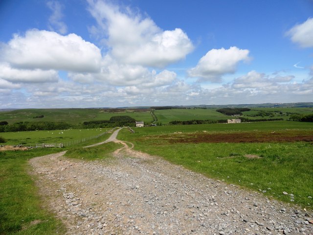
Cabin Hill, located in Durham, is a picturesque hill that stands as a prominent natural landmark in the region. Situated amidst lush greenery, it is a popular spot for locals and tourists alike, offering breathtaking views of the surrounding countryside.

Rising to an elevation of approximately 500 feet, Cabin Hill is classified as a hill rather than a mountain due to its moderate height. The hill is characterized by its gentle slopes and a rounded summit, making it easily accessible for hikers and nature enthusiasts of all levels of experience.

The name "Cabin Hill" is believed to have originated from the presence of a small log cabin that once stood at the top of the hill, serving as a shelter for shepherds and farmers in the area. Though the cabin no longer exists, the name has persisted and become synonymous with the hill itself.

The area surrounding Cabin Hill is abundant in diverse flora and fauna, making it a haven for wildlife enthusiasts. Visitors can expect to encounter various species of birds, butterflies, and small mammals while exploring the hill's trails and pathways.

The hill is also a popular destination for outdoor activities such as hiking, picnicking, and photography. Its serene ambiance and panoramic views make it an ideal spot for nature lovers seeking tranquility and a break from the hustle and bustle of city life.

Overall, Cabin Hill is a scenic and accessible natural landmark in Durham, offering visitors an opportunity to immerse themselves in the beauty of nature while enjoying outdoor activities and stunning vistas.

If you have any feedback on the listing, please let us know in the comments section below.

Cabin Hill Images

Images are sourced within 2km of 54.686839/-1.8869035 or Grid Reference NZ0732. Thanks to Geograph Open Source API. All images are credited.

The Lodge of St. John's Hall South of the Weardale village of Wolsingham a 'dead end' road gives an approach to several isolated buildings. The grandest of them is St. John's Hall, presently (April 2011) unoccupied and deteriorating <a title="https://www.geograph.org.uk/photo/1781360" href="https://www.geograph.org.uk/photo/1781360">Link</a>. This bungalow is the lodge for the hall; it's also unoccupied and is deteriorating as well.
The Lodge of St. John's Hall
South of the Weardale village of Wolsingham a 'dead end' road gives an approach to several isolated buildings. The grandest of them is St. John's Hall, presently (April 2011) unoccupied and deteriorating Link. This bungalow is the lodge for the hall; it's also unoccupied and is deteriorating as well.
West Moor Plantation West Moor Plantation lies adjacent to moorland and to the north-east of Hamsterley Forest.
West Moor Plantation
West Moor Plantation lies adjacent to moorland and to the north-east of Hamsterley Forest.
Wildflower Meadow, Hamsterley Forest
Ruddy Carr Ruddy Carr seen from near Harthope.
Ruddy Carr
Ruddy Carr seen from near Harthope.
Valley of the Harthope Beck Looking across the little valley from the Hmasterley road.
Valley of the Harthope Beck
Looking across the little valley from the Hmasterley road.
Dryderdale Plantation There has evidently been a lot of clear felling going on recently.
Dryderdale Plantation
There has evidently been a lot of clear felling going on recently.
View South from Stanhope Lane A lot of forestry plantations visible from here.
View South from Stanhope Lane
A lot of forestry plantations visible from here.
Looking along Stanhope Lane This track runs along the South side of West Moor Plantation. At its Western end it leads out onto open moorland.
Looking along Stanhope Lane
This track runs along the South side of West Moor Plantation. At its Western end it leads out onto open moorland.
View East from Cabin Hill Looking over the open moor towards Dryderdale.
View East from Cabin Hill
Looking over the open moor towards Dryderdale.
Looking towards Doctor's Gate View across the open moor from Cabin Hill.
Looking towards Doctor's Gate
View across the open moor from Cabin Hill.
Looking West from near Blackburn Lodge View from the road North of the Lodge. St John's Hall in the distance.
Looking West from near Blackburn Lodge
View from the road North of the Lodge. St John's Hall in the distance.
Distant view of Blackburn Lodge Viewed from the South across the moorland.
Distant view of Blackburn Lodge
Viewed from the South across the moorland.
Ford at Hamsterley Forest This ford is found on the Ayhope Beck in the North Plantation of Hamsterley Forest.
Ford at Hamsterley Forest
This ford is found on the Ayhope Beck in the North Plantation of Hamsterley Forest.
View west across the moors Looking west on the moors south of Wolsingham, near Doctor's Gate. The hills on the north side of Weardale on the horizon.
View west across the moors
Looking west on the moors south of Wolsingham, near Doctor's Gate. The hills on the north side of Weardale on the horizon.
Looking north near Doctor's Gate View looking north towards Weardale from the moors just NW of Doctor's Gate.
Looking north near Doctor's Gate
View looking north towards Weardale from the moors just NW of Doctor's Gate.
St John's Hall Old hall on the edge of the moors south of Wolsingham.
St John's Hall
Old hall on the edge of the moors south of Wolsingham.
Track leading to Blackburn Lodge Looking north along the track, with Blackburn Cottage on the right. These farms are on the edge of the moors south of Wolsingham.
Track leading to Blackburn Lodge
Looking north along the track, with Blackburn Cottage on the right. These farms are on the edge of the moors south of Wolsingham.
Tree with crag The tree is perched at a rock outcrop across which falls a minor stream feeding into Ayhope Beck.
Tree with crag
The tree is perched at a rock outcrop across which falls a minor stream feeding into Ayhope Beck.
Show me another place!

Cabin Hill is located at Grid Ref: NZ0732 (Lat: 54.686839, Lng: -1.8869035)

Unitary Authority: County Durham

Police Authority: Durham

What 3 Words

///royal.ballooned.ants. Near Hamsterley, Co. Durham

Nearby Locations

Cabin Hill

Related Wikis

Low Redford Meadows

Low Redford Meadows is a Site of Special Scientific Interest in the Teesdale district of County Durham, England. It consists of two separate areas of meadows...

Frog Wood Bog

Frog Wood Bog is a Site of Special Scientific Interest in the Teesdale district of County Durham, England. It lies alongside Bedburn Beck, approximately...

Hamsterley Forest

Hamsterley Forest is a commercial forest in County Durham owned and managed by Forestry England. It is the largest forest in County Durham and covers...

Bedburn

Bedburn is a village in County Durham, in England. It is in the civil parish of South Bedburn, near Hamsterley, and Hamsterley Forest. The Bedburn Beck...

South Bedburn

South Bedburn is a civil parish in County Durham, England. The population of the civil parish at the 2011 census was 171. == References == == External... ==

Weardale

Weardale is a dale, or valley, on the east side of the Pennines in County Durham, England. Large parts of Weardale fall within the North Pennines Area...

Wear Valley

Wear Valley was, from 1974 to 2009, a local government district in County Durham, England. Its council and district capital was Crook. The district covered...

County Durham

County Durham, officially simply Durham (/ˈdʌrəm/), is a ceremonial county in North East England. The county borders Northumberland and Tyne and Wear to...

Have you been to Cabin Hill?

Leave your review of Cabin Hill below (or comments, questions and feedback).