Chrome Hill

Hill, Mountain in Derbyshire Derbyshire Dales

England

Chrome Hill

Parkhouse Hill as seen from Axe Edge Trig Point One of the few hills visible during this cold air inversion. Chrome Hill is on the right.
Parkhouse Hill as seen from Axe Edge Trig Point Credit: Colin Park

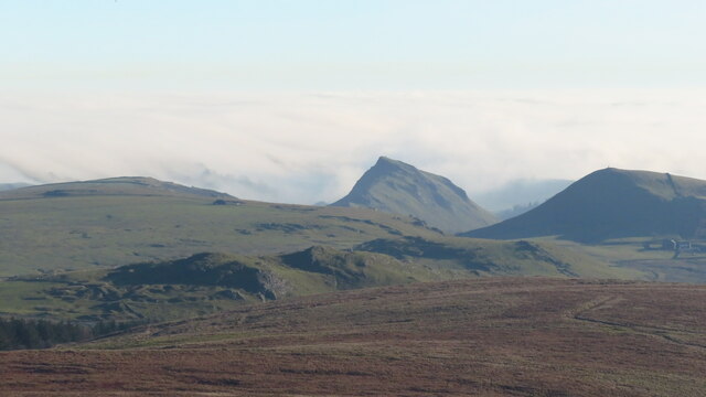
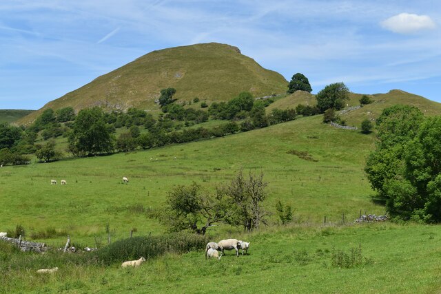
Chrome Hill is a distinctive limestone hill located in the Peak District National Park in Derbyshire, England. It is known for its unique shape, which resembles a giant wedge of cheese, and is a popular destination for hikers and nature enthusiasts.

Standing at a height of 1,385 feet (422 meters) above sea level, Chrome Hill offers stunning panoramic views of the surrounding countryside, including the neighboring Peak District hills and valleys. The hill is made up of layers of limestone rock, which have been shaped by centuries of erosion to create its steep, angular slopes.

The area surrounding Chrome Hill is rich in wildlife, with rare plants and flowers thriving in the limestone grassland. The hill is also home to a variety of bird species, including peregrine falcons and red grouse.

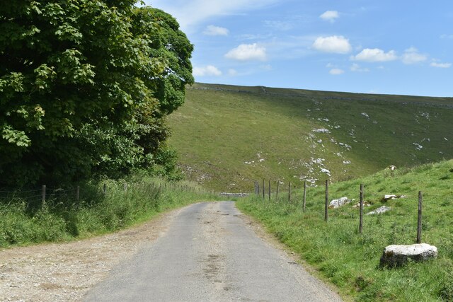
Visitors to Chrome Hill can enjoy a challenging hike to the summit, where they can take in the breathtaking views and explore the unique rock formations. The hill is easily accessible from the nearby village of Longnor, and is a must-visit destination for anyone looking to experience the natural beauty of the Peak District.

If you have any feedback on the listing, please let us know in the comments section below.

Chrome Hill Images

Images are sourced within 2km of 53.203079/-1.8956738 or Grid Reference SK0767. Thanks to Geograph Open Source API. All images are credited.

Parkhouse Hill as seen from Axe Edge Trig Point One of the few hills visible during this cold air inversion. Chrome Hill is on the right.
Parkhouse Hill as seen from Axe Edge Trig Point
One of the few hills visible during this cold air inversion. Chrome Hill is on the right.
Parkhouse and Chrome Hills Looking southwest through the Parkhouse and Chrome Hills, near Earl Sterndale in the Derbyshire Peak District.

- image by Phil Brandon Hunter - philbhu.com - P1060685A
Parkhouse and Chrome Hills
Looking southwest through the Parkhouse and Chrome Hills, near Earl Sterndale in the Derbyshire Peak District. - image by Phil Brandon Hunter - philbhu.com - P1060685A
Hollinsclough Derbyshire Peaks The view northeast from south of Hollinsclough village, Derbyshire Peak District

- image by Phil Brandon Hunter - philbhu.com - P7230099A
Hollinsclough Derbyshire Peaks
The view northeast from south of Hollinsclough village, Derbyshire Peak District - image by Phil Brandon Hunter - philbhu.com - P7230099A
Hollinsclough Derbyshire Peaks Chrome Hill and Parkhouse Hill from the southwest, viewed from  southeast of Hollinsclough village

- image by Phil Brandon Hunter - philbhu.com - P7230106A
Hollinsclough Derbyshire Peaks
Chrome Hill and Parkhouse Hill from the southwest, viewed from southeast of Hollinsclough village - image by Phil Brandon Hunter - philbhu.com - P7230106A
Underhill Farm
Underhill Farm
Parkhouse Hill, seen from Glutton Bridge The tree and building are beside the track from Crowdicote.
Parkhouse Hill, seen from Glutton Bridge
The tree and building are beside the track from Crowdicote.
Parkhouse Hill
Parkhouse Hill
Chrome Hill
Chrome Hill
Cattle grid south of Dowall Hall In the pass between Chrome Hill and Parkhouse Hill.
Cattle grid south of Dowall Hall
In the pass between Chrome Hill and Parkhouse Hill.
Parkhouse Hill
Parkhouse Hill
Dowall Hall
Dowall Hall
View along the ridge of Chrome Hill to Parkhouse Hill Along the “dragon’s back” of these two limestone reef knolls.
View along the ridge of Chrome Hill to Parkhouse Hill
Along the “dragon’s back” of these two limestone reef knolls.
The Dove Valley from the summit of Chrome Hill Parkhouse Hill on the left.
The Dove Valley from the summit of Chrome Hill
Parkhouse Hill on the left.
Dowel Dale, shortly above Dowell Hall Both spellings as per Ordnance Survey. This section of the valley is a miniature limestone gorge.
Dowel Dale, shortly above Dowell Hall
Both spellings as per Ordnance Survey. This section of the valley is a miniature limestone gorge.
Dowel Dale Limestone valley complete with crags and caves.
Dowel Dale
Limestone valley complete with crags and caves.
Looking down Dowel Dale
Greensides
Greensides
Lane into Dowel Dale at Owl Hole The lane descends from this point to Dowall Hall through a miniature limestone valley, with crags and caves and a short gorge section at the lower end.
Lane into Dowel Dale at Owl Hole
The lane descends from this point to Dowall Hall through a miniature limestone valley, with crags and caves and a short gorge section at the lower end.
Show me another place!

Chrome Hill is located at Grid Ref: SK0767 (Lat: 53.203079, Lng: -1.8956738)

Administrative County: Derbyshire

District: Derbyshire Dales

Police Authority: Derbyshire

What 3 Words

///whispers.feuds.subsystem. Near Buxton, Derbyshire

Nearby Locations

Dowel Cave Chrome Hill

Related Wikis

Chrome Hill

Chrome Hill is a limestone reef knoll in Derbyshire, England, in the upper Dove valley beside the border with Staffordshire, within the civil parish...

Hollinsclough

Hollinsclough is a small rural village in the county of Staffordshire in the English Midlands. It is within the Peak District National Park. == Location... ==

Parkhouse Hill

Parkhouse Hill is a small but distinctive hill in the Peak District National Park of the Hartington Middle Quarter civil parish, in the English county...

Hollins Hill

Hollins Hill is a gritstone hill in the Derbyshire Peak District near the village of Hollinsclough. The summit is 450 metres (1,480 ft) above sea level...

Nearby Amenities

Located within 500m of 53.203079,-1.8956738
Chrome Hill
Ele: 443
Natural: peak
Source: https://www.hill-bagging.co.uk/mountaindetails.php?qu=S&rf=16510
Wikidata: Q5113772
Wikipedia: en:Chrome Hill
Lat/Long: 53.2030883/-1.895713
Barrier: cattle_grid
Lat/Long: 53.1997758/-1.8960657
Barrier: cattle_grid
Lat/Long: 53.2009133/-1.900034
Inscription: In memory of Bill Etches, Dowall Hall, 1920-2006
Memorial: plaque
Lat/Long: 53.2016738/-1.8907182
The data included in this document is from www.openstreetmap.org. The data is made available under ODbL.

Have you been to Chrome Hill?

Leave your review of Chrome Hill below (or comments, questions and feedback).