Bale Hill

Hill, Mountain in Durham

England

Bale Hill

Waskerley Way
Waskerley Way Credit: Clive Nicholson

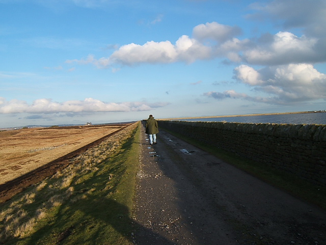
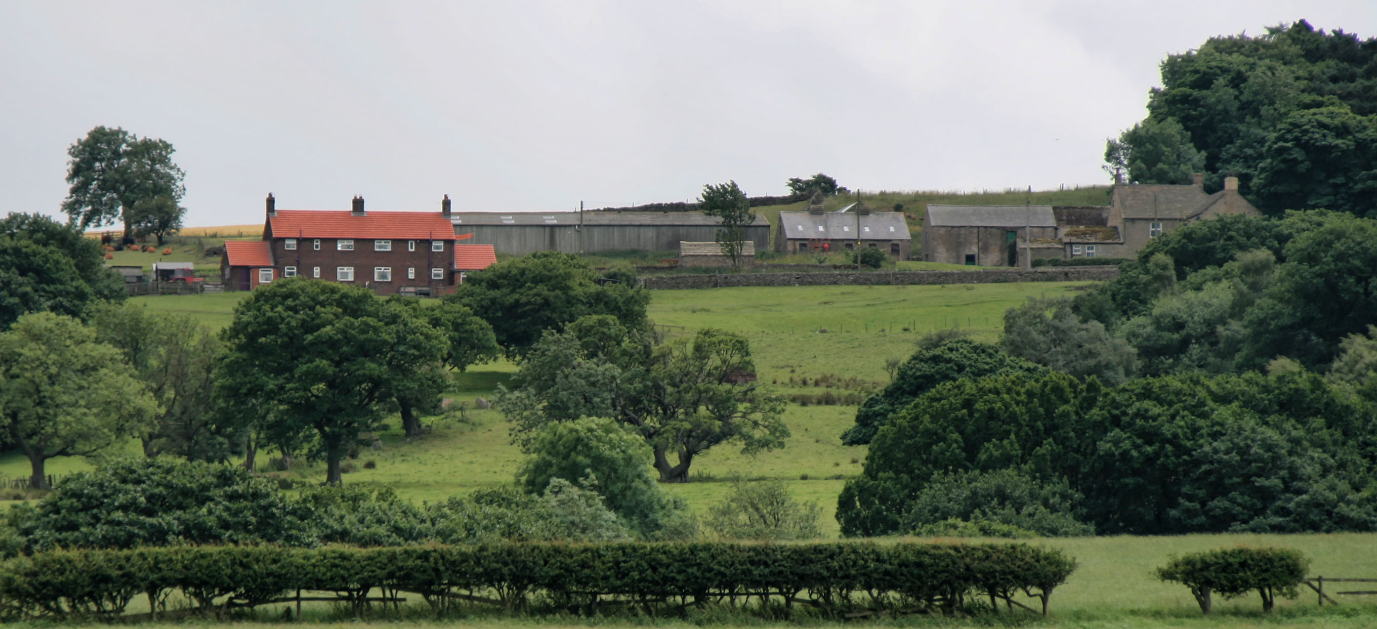
Bale Hill, located in County Durham, England, is a prominent hill that offers breathtaking views of the surrounding countryside. Standing at approximately 270 meters above sea level, it is considered one of the highest points in the region. Although not officially classified as a mountain, it provides a remarkable vantage point for visitors to appreciate the beauty of the Durham landscape.

The hill is covered in lush greenery, with a variety of trees and plants adorning its slopes. It is home to a diverse range of wildlife, including birds, rabbits, and other small mammals. This makes it a popular spot for nature enthusiasts and birdwatchers.

Bale Hill is easily accessible, with a network of footpaths and trails leading to its summit. These paths are well-maintained, allowing visitors to enjoy a leisurely stroll or a more challenging hike to reach the top. The ascent is rewarded with panoramic views of the Durham Dales, rolling hills, and picturesque villages nestled in the valleys below.

At the summit, there is a designated viewpoint area where visitors can pause and take in the stunning vistas. On clear days, it is possible to see as far as the North Pennines and even glimpse the distant North Sea coastline.

Whether it is for a peaceful walk, a picnic, or simply to admire the stunning scenery, Bale Hill is a must-visit destination for nature lovers and those seeking a tranquil escape in the heart of Durham.

If you have any feedback on the listing, please let us know in the comments section below.

Bale Hill Images

Images are sourced within 2km of 54.821818/-1.9241441 or Grid Reference NZ0447. Thanks to Geograph Open Source API. All images are credited.

Waskerley Way
Waskerley Way
Horseshoe Bridge On the original railway to Waskerley, before the deviation was built.
Horseshoe Bridge
On the original railway to Waskerley, before the deviation was built.
Smiddy Shaw Reservoir On horizon near right Pontop Pike TV mast can be seen.
Smiddy Shaw Reservoir
On horizon near right Pontop Pike TV mast can be seen.
The Moorcock Inn Near to Smiddyshaw reservoir
The Moorcock Inn
Near to Smiddyshaw reservoir
Winter sunshine over Waskerley Way
Dene Howl Farm Built around 1700 by a Mr Shirley. Legend says that Mr Shirley and others brought the body of the Earl of Derwentwater back after losing his head in the Jacobite Rebellion of 1715, to be buried in nearby Dilston.
Dene Howl Farm
Built around 1700 by a Mr Shirley. Legend says that Mr Shirley and others brought the body of the Earl of Derwentwater back after losing his head in the Jacobite Rebellion of 1715, to be buried in nearby Dilston.
Fell Close Close to medieval lead mines the derelict house in the background was built in 1760. It was once thatched in heather and the old beams known as cruck trusses (usually wood from the same tree) can still be seen.
Fell Close
Close to medieval lead mines the derelict house in the background was built in 1760. It was once thatched in heather and the old beams known as cruck trusses (usually wood from the same tree) can still be seen.
Ancient Door The original oak studded door of Fell Close House
Ancient Door
The original oak studded door of Fell Close House
Engine House Once this derelict building housed the engine that moved the cage up and down the mine shaft.  It used to have a large chimney which has now been lost to time as sadly, has the engine.
Engine House
Once this derelict building housed the engine that moved the cage up and down the mine shaft. It used to have a large chimney which has now been lost to time as sadly, has the engine.
Fell Close How sad that this ancient building be left to fall into dereliction. The crucks can clearly be seen which would have supported a heather thatch. An ancient oak door is around the corner to the left of the building.
Fell Close
How sad that this ancient building be left to fall into dereliction. The crucks can clearly be seen which would have supported a heather thatch. An ancient oak door is around the corner to the left of the building.
Fell Close On a clear day you can see forever.
Fell Close
On a clear day you can see forever.
Ancient Larch Tree Under this tree, John Wesley preached to the lead miners in 1772. Struck by lightning but still flourishing after more than 200 years.
Ancient Larch Tree
Under this tree, John Wesley preached to the lead miners in 1772. Struck by lightning but still flourishing after more than 200 years.
View from Fell Close A rather dull and cloudy day spoilt an otherwise magnificent view.
View from Fell Close
A rather dull and cloudy day spoilt an otherwise magnificent view.
Catchwater Channel Catchwater Channel leading form Smiddy Shaw Reservoir to Hisehope Reservoir.  In the background one of several footbridges that cross the channel.  These were constructed by about 1872.
Catchwater Channel
Catchwater Channel leading form Smiddy Shaw Reservoir to Hisehope Reservoir. In the background one of several footbridges that cross the channel. These were constructed by about 1872.
Footpath on Muggleswick Common Footpath leading from Smiddy Shaw reservoir to Lamb Shield Farm
Footpath on Muggleswick Common
Footpath leading from Smiddy Shaw reservoir to Lamb Shield Farm
Farmland and the remains of a house? On 1:25000 map Hisefield House is marked.  Cannot find any other reference than Hisefield House, although on old maps area called Harefield or Horsefield.  These piles of stones aren't consistent with piles of stones one normally finds where houses once stood.
Farmland and the remains of a house?
On 1:25000 map Hisefield House is marked. Cannot find any other reference than Hisefield House, although on old maps area called Harefield or Horsefield. These piles of stones aren't consistent with piles of stones one normally finds where houses once stood.
A secure building Adjoining the reservoir one can only guess at the use of this building. It once had a large opening in the side, now blocked up, so must be awfully dark inside.
A secure building
Adjoining the reservoir one can only guess at the use of this building. It once had a large opening in the side, now blocked up, so must be awfully dark inside.
Along the dam Smiddy Shaw Reservoir is unusual in that its earthen dam turns back at right angles when at the highest point of the dam.
Along the dam
Smiddy Shaw Reservoir is unusual in that its earthen dam turns back at right angles when at the highest point of the dam.
Show me another place!

Bale Hill is located at Grid Ref: NZ0447 (Lat: 54.821818, Lng: -1.9241441)

Unitary Authority: County Durham

Police Authority: Durham

What 3 Words

///spoil.bathtubs.proudest. Near Muggleswick, Co. Durham

Related Wikis

Hisehope Burn Valley

Hisehope Burn Valley is a Site of Special Scientific Interest in the Derwentside district of Durham, England. It consists of two separate parcels of land...

Derwent Gorge and Horsleyhope Ravine

Derwent Gorge and Horsleyhope Ravine is a Site of Special Scientific Interest in the Derwentside district of north County Durham and the Tynedale district...

River Browney

The River Browney is a river in County Durham, England, and the largest tributary of the River Wear. The River Browney rises from a spring in Head Plantation...

Healeyfield

Healeyfield is a village and civil parish in County Durham, England. The population of the civil parish taken from the 2011 census was 1,544. It is situated...

Related Videos

Camping with Luke and Keane

Today I will be camping overnight with my good friends Keane & Luke. We will be building fire and cooking food on said fire.

Wild Rabbit Catch and Cook

Today I am going to show you how to prepare a wild rabbit for cooking over the campfire. I am using a technique by frying the ...

50K WASKERLEY WAY BIKE RIDE GONE WRONG!? Biking Talk | Future Biking Plans

Hi Guys, welcome back to the channel. In today's video I go for a 50K bike ride up to Waskerley Way after work & have a small ...

Nearby Amenities

Located within 500m of 54.821818,-1.9241441
Barrier: cattle_grid
Bicycle: yes
Foot: yes
Motorcar: yes
Motorcycle: yes
Lat/Long: 54.8225068/-1.9185276
Bus Stop
Gold Hill
Naptan AtcoCode: 13001825A
Naptan Bearing: N
Naptan CommonName: Gold Hill
Naptan Indicator: north bound
Naptan Landmark: Landmark not known
Naptan NaptanCode: durajpwm
Naptan Notes: South of Goldhill Farm- Goldhill Lane- Muggleswick.
Naptan Street: Goldhill Lane
Naptan Verified: no
Source: naptan_import
Lat/Long: 54.8224312/-1.9186469
Bus Stop
Gold Hill
Naptan AtcoCode: 13001825E
Naptan Bearing: S
Naptan CommonName: Gold Hill
Naptan Indicator: south bound
Naptan Landmark: Landmark not known
Naptan NaptanCode: durajpwp
Naptan Notes: South of Goldhill Farm- Goldhill Lane- Muggleswick.
Naptan Street: Goldhill Lane
Naptan Verified: no
Source: naptan_import
Lat/Long: 54.8224042/-1.9185536
Ford: yes
Lat/Long: 54.8248813/-1.9285187
Power: pole
Lat/Long: 54.8198/-1.9207956
Power: pole
Lat/Long: 54.819858/-1.9198635
Power: pole
Lat/Long: 54.8199198/-1.9189382
Power: pole
Lat/Long: 54.8199746/-1.917994
Power: pole
Lat/Long: 54.8200395/-1.9170579
Power: pole
Lat/Long: 54.8232437/-1.9242141
Power: pole
Lat/Long: 54.8235365/-1.9253553
Power: pole
Lat/Long: 54.823674/-1.9259213
Power: pole
Lat/Long: 54.8239491/-1.9269995
Power: pole
Lat/Long: 54.8243014/-1.9284211
Barrier: stile
Stile: stepover
Lat/Long: 54.8221517/-1.9182409
Barrier: stile
Material: wood
Source: survey
Stile: stepover
Lat/Long: 54.8221591/-1.9182785
Information: guidepost
Tourism: information
Lat/Long: 54.8222789/-1.9187492
Information: guidepost
Tourism: information
Lat/Long: 54.8222888/-1.9185935
Power: pole
Lat/Long: 54.8228587/-1.9225745
Power: pole
Lat/Long: 54.8224942/-1.9211852
Power: pole
Lat/Long: 54.8222191/-1.9200761
Power: pole
Lat/Long: 54.8219058/-1.9188308
The data included in this document is from www.openstreetmap.org. The data is made available under ODbL.

Have you been to Bale Hill?

Leave your review of Bale Hill below (or comments, questions and feedback).