Gravel Hill

Hill, Mountain in Dorset

England

Gravel Hill

Footpath across golf course fairway A public right-of-way across one of the fairways at Broadstone Golf Course, at Corfe Hills.
Footpath across golf course fairway Credit: Peter Kazmierczak

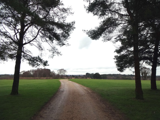
Gravel Hill is a prominent hill located in the county of Dorset, England. It lies approximately 14 kilometers northwest of the town of Dorchester and is a part of the Dorset Area of Outstanding Natural Beauty. Rising to a height of 185 meters, Gravel Hill offers breathtaking views of the surrounding countryside and is a popular destination for nature enthusiasts and hikers.

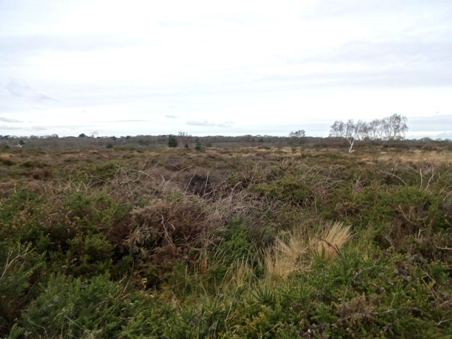
Covered in a lush blanket of greenery, Gravel Hill is known for its diverse flora and fauna. The hill is predominantly covered with grassland, but scattered patches of woodland can also be found. Its slopes are home to a variety of wildflowers, including bluebells, primroses, and orchids, which create a vibrant and colorful display during the spring and summer months.

The hill also boasts an array of wildlife, attracting birdwatchers and nature lovers. Visitors may spot various bird species, such as skylarks, kestrels, and buzzards soaring overhead. The surrounding countryside provides a habitat for mammals like rabbits, foxes, and deer.

Gravel Hill is accessible via well-maintained footpaths and offers several walking routes, allowing visitors to explore its natural beauty. The hill's location near the picturesque village of Martinstown and the famous Jurassic Coastline adds to its charm, making it a popular destination for both locals and tourists alike.

Overall, Gravel Hill is a tranquil and scenic spot in Dorset, offering a peaceful retreat for nature enthusiasts and a chance to immerse oneself in the stunning landscapes and wildlife of the region.

If you have any feedback on the listing, please let us know in the comments section below.

Gravel Hill Images

Images are sourced within 2km of 50.777347/-1.9788154 or Grid Reference SZ0197. Thanks to Geograph Open Source API. All images are credited.

Footpath across golf course fairway A public right-of-way across one of the fairways at Broadstone Golf Course, at Corfe Hills.
Footpath across golf course fairway
A public right-of-way across one of the fairways at Broadstone Golf Course, at Corfe Hills.
Corfe and Barrow Hills Nature Reserve Looking towards Rushcombe Bottom, from the footpath across the Corfe and Barrow Hills Nature Reserve.
Corfe and Barrow Hills Nature Reserve
Looking towards Rushcombe Bottom, from the footpath across the Corfe and Barrow Hills Nature Reserve.
Houses on Ashington Lane
Track off Ashington Lane
Path on disused railway
The Old Church, Happy Bottom
House, Happy Bottom
House, Happy Bottom
Merley Park Road
Merley Park Road
Elizabeth II postbox, Happy Bottom Postbox No. BH21 133.
Elizabeth II postbox, Happy Bottom
Postbox No. BH21 133.
The Old Church, Happy Bottom Showing position of Postbox No. BH21 133.
The Old Church, Happy Bottom
Showing position of Postbox No. BH21 133.
Corfe Hills, footpath From Higher Blandford Road across Broadstone Golf Club to the dismantled railway line.
Corfe Hills, footpath
From Higher Blandford Road across Broadstone Golf Club to the dismantled railway line.
Corfe Hills, heathland Part of Corfe Hills Nature Reserve, with Broadstone Golf Club to the right in the distance: <span class="nowrap"><a title="http://www.boroughofpoole.com/facilities/ref:F465e9bc762de2/" rel="nofollow ugc noopener" href="http://www.boroughofpoole.com/facilities/ref:F465e9bc762de2/">Link</a><img style="margin-left:2px;" alt="External link" title="External link - shift click to open in new window" src="https://s1.geograph.org.uk/img/external.png" width="10" height="10"/></span>
Corfe Hills, heathland
Part of Corfe Hills Nature Reserve, with Broadstone Golf Club to the right in the distance: LinkExternal link
Corfe Hills, heathland On Corfe Hills Nature Reserve, looking towards Rushcombe Bottom. <span class="nowrap"><a title="http://www.boroughofpoole.com/facilities/ref:F465e9bc762de2/" rel="nofollow ugc noopener" href="http://www.boroughofpoole.com/facilities/ref:F465e9bc762de2/">Link</a><img style="margin-left:2px;" alt="External link" title="External link - shift click to open in new window" src="https://s1.geograph.org.uk/img/external.png" width="10" height="10"/></span>
Corfe Hills, heathland
On Corfe Hills Nature Reserve, looking towards Rushcombe Bottom. LinkExternal link
Corfe Hills, footpath From Higher Blandford Road towards Rushcombe Bottom, where public access finishes. Broadstone Golf Club doesn't seem to encourage visitors.
Corfe Hills, footpath
From Higher Blandford Road towards Rushcombe Bottom, where public access finishes. Broadstone Golf Club doesn't seem to encourage visitors.
Broadstone, Rushcombe Bottom Looking across the bottom, which is used by Broadstone Golf Club.
Broadstone, Rushcombe Bottom
Looking across the bottom, which is used by Broadstone Golf Club.
The Old Church, Ashington
Track, Barrow Hill
Track, Barrow Hill
Tumulus, Barrow Hill
Show me another place!

Gravel Hill is located at Grid Ref: SZ0197 (Lat: 50.777347, Lng: -1.9788154)

Unitary Authority: Bournemouth, Christchurch and Poole

Police Authority: Dorset

What 3 Words

///soils.shack.powder. Near Wimborne Minster, Dorset

Nearby Locations

Gravel Hill

Related Wikis

Oakley, Dorset

Oakley is a village community in Dorset, England. Sitting just south of the River Stour it borders the suburb of Merley and the village of Canford Magna...

Merley

Merley is a large housing estate in Poole, a mile (2 km) south of Wimborne Minster. Originally called Myrle, Merley was a manor in the tithing of Great...

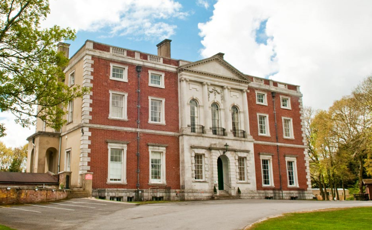
Merley House, Wimborne

Merley House in Wimborne, Dorset, England, is a building of historical significance and is Grade I listed on the English Heritage Register. It was built...

Corfe & Barrow Hills

Corfe & Barrow Hills is a 102.8 hectare biological Site of Special Scientific Interest in Dorset, notified in 1986. One part of it is a Local Nature Reserve...

Nearby Amenities

Located within 500m of 50.777347,-1.9788154
Turning Circle
Lat/Long: 50.778524/-1.9733809
Note: moved onto Rempstone Road round the corner in 2015
Old Ref: BH21 54
Post Box Type: pillar
Removed Amenity: post_box
Lat/Long: 50.777721/-1.975136
Turning Circle
Lat/Long: 50.7778917/-1.9737335
Turning Circle
Lat/Long: 50.778256/-1.9765432
Crossing
Crossing: unmarked
Crossing Island: no
Kerb: lowered
Tactile Paving: no
Lat/Long: 50.7777049/-1.974556
Crossing
Button Operated: yes
Crossing: traffic_signals
Crossing Island: yes
Kerb: lowered
Tactile Paving: yes
Traffic Signals Sound: no
Traffic Signals Vibration: yes
Lat/Long: 50.7780928/-1.9778293
Crossing
Crossing: unmarked
Crossing Island: no
Kerb: lowered
Tactile Paving: no
Lat/Long: 50.7773578/-1.9725965
Passing Place
Lat/Long: 50.7745366/-1.9839157
Passing Place
Lat/Long: 50.7748134/-1.9827287
Passing Place
Lat/Long: 50.7753495/-1.9812649
Passing Place
Lat/Long: 50.7757437/-1.9805092
Passing Place
Lat/Long: 50.7757897/-1.9799393
Passing Place
Lat/Long: 50.7757484/-1.978953
Kerb: raised
Lat/Long: 50.7799723/-1.9733698
Kerb: raised
Lat/Long: 50.7800409/-1.9751002
Kerb: raised
Tactile Paving: no
Lat/Long: 50.7805078/-1.9748759
Kerb: raised
Tactile Paving: no
Lat/Long: 50.780574/-1.9751164
Crossing
Crossing: unmarked
Crossing Island: no
Kerb: lowered
Tactile Paving: no
Lat/Long: 50.7806682/-1.9754159
Crossing
Crossing: unmarked
Crossing Island: no
Kerb: lowered
Tactile Paving: no
Lat/Long: 50.7812647/-1.9757753
Covered: no
Leisure: picnic_table
Lat/Long: 50.774625/-1.98393
Generator Method: photovoltaic
Generator Output Electricity: yes
Generator Source: solar
Generator Type: solar_photovoltaic_panel
Location: roof
Power: generator
Lat/Long: 50.7801283/-1.9790782
Generator Method: photovoltaic
Generator Output Electricity: yes
Generator Source: solar
Generator Type: solar_photovoltaic_panel
Location: roof
Power: generator
Lat/Long: 50.7807287/-1.9794403
Generator Method: photovoltaic
Generator Output Electricity: yes
Generator Source: solar
Generator Type: solar_photovoltaic_panel
Location: roof
Power: generator
Lat/Long: 50.7815883/-1.9767439
Generator Method: photovoltaic
Generator Output Electricity: yes
Generator Source: solar
Generator Type: solar_photovoltaic_panel
Location: roof
Power: generator
Lat/Long: 50.7815968/-1.9766943
Generator Method: photovoltaic
Generator Output Electricity: yes
Generator Source: solar
Generator Type: solar_photovoltaic_panel
Location: roof
Power: generator
Lat/Long: 50.781233/-1.9768526
Generator Method: photovoltaic
Generator Output Electricity: yes
Generator Source: solar
Generator Type: solar_photovoltaic_panel
Location: roof
Power: generator
Lat/Long: 50.7799246/-1.9798285
Generator Method: photovoltaic
Generator Output Electricity: yes
Generator Source: solar
Generator Type: solar_photovoltaic_panel
Location: roof
Power: generator
Lat/Long: 50.7795668/-1.9800323
Generator Method: photovoltaic
Generator Output Electricity: yes
Generator Source: solar
Generator Type: solar_photovoltaic_panel
Location: roof
Power: generator
Lat/Long: 50.7794065/-1.9794396
Generator Method: photovoltaic
Generator Output Electricity: yes
Generator Source: solar
Generator Type: solar_photovoltaic_panel
Location: roof
Power: generator
Lat/Long: 50.7787569/-1.9794034
Generator Method: photovoltaic
Generator Output Electricity: yes
Generator Source: solar
Generator Type: solar_photovoltaic_panel
Location: roof
Power: generator
Lat/Long: 50.7788417/-1.9763658
Generator Method: photovoltaic
Generator Output Electricity: yes
Generator Source: solar
Generator Type: solar_photovoltaic_panel
Location: roof
Power: generator
Lat/Long: 50.7787434/-1.9768271
Generator Method: photovoltaic
Generator Output Electricity: yes
Generator Source: solar
Generator Type: solar_photovoltaic_panel
Location: roof
Power: generator
Lat/Long: 50.7788375/-1.9768526
Generator Method: photovoltaic
Generator Output Electricity: yes
Generator Source: solar
Generator Type: solar_photovoltaic_panel
Location: roof
Power: generator
Lat/Long: 50.7781947/-1.9767761
Generator Method: photovoltaic
Generator Output Electricity: yes
Generator Source: solar
Generator Type: solar_photovoltaic_panel
Location: roof
Power: generator
Lat/Long: 50.7790283/-1.9769089
Generator Method: photovoltaic
Generator Output Electricity: yes
Generator Source: solar
Generator Type: solar_photovoltaic_panel
Location: roof
Power: generator
Lat/Long: 50.7785102/-1.9750515
Generator Method: photovoltaic
Generator Output Electricity: yes
Generator Source: solar
Generator Type: solar_photovoltaic_panel
Location: roof
Power: generator
Lat/Long: 50.7785924/-1.9747323
Generator Method: photovoltaic
Generator Output Electricity: yes
Generator Source: solar
Generator Type: solar_photovoltaic_panel
Location: roof
Power: generator
Lat/Long: 50.7788809/-1.9750381
Generator Method: photovoltaic
Generator Output Electricity: yes
Generator Source: solar
Generator Type: solar_photovoltaic_panel
Location: roof
Power: generator
Lat/Long: 50.777982/-1.9752024
Generator Method: photovoltaic
Generator Output Electricity: yes
Generator Source: solar
Generator Type: solar_photovoltaic_panel
Location: roof
Power: generator
Lat/Long: 50.7792998/-1.9724692
Golf: pin
Lat/Long: 50.7775559/-1.983613
Post Box
Collection Times: Mo-Fr 05:45, Sa 11:30
Note: was on Queen Annes Drive till 2015
Operator: Royal Mail
Operator Wikidata: Q638098
Post Box Type: pillar
Ref: BH21 54
Royal Cypher: EIIR
Royal Cypher Wikidata: Q33102113
Lat/Long: 50.77805/-1.9743101
Bicycle Rental
Rempstone Road
Bicycle Rental: dropoff_point
Capacity: 5
Email: support@beryl.cc
Fee: yes
Name Signed: no
Network: Beryl - Bournemouth Poole Christchurch
Official Name: Rempstone Road
Operator: Beryl
Operator Wikidata: Q106575369
Payment App: yes
Payment App Android: cc.beryl.basis
Payment App Ios: 1386768364
Payment Cash: no
Payment Credit Cards: no
Payment Cryptocurrencies: no
Payment Debit Cards: no
Payment Electronic Purses: no
Phone: +44 20 3003 5044
Ref Gbfs: beryl_bcp:379
Rental: city_bike
Website: https://beryl.cc/scheme/bournemouth-christchurch-and-poole
Lat/Long: 50.7777328/-1.974665
Bus Stop
Mimosa Avenue
Bench: no
Bin: no
Bus: yes
Naptan AtcoCode: 1280POA11356
Naptan Bearing: N
Naptan CommonName: Mimosa Avenue
Naptan Indicator: opp
Naptan NaptanCode: pleawam
Naptan PlusbusZoneRef: BOMO
Naptan Street: Rempstone Road
Naptan Verified: no
Public Transport: platform
Shelter: no
Tactile Paving: yes
Lat/Long: 50.7812063/-1.9755194
Bus Stop
Mimosa Avenue
Bench: no
Bin: no
Bus: yes
Naptan AtcoCode: 1280POA11355
Naptan Bearing: S
Naptan CommonName: Mimosa Avenue
Naptan Indicator: S-bound
Naptan NaptanCode: pleawdg
Naptan PlusbusZoneRef: BOMO
Naptan Street: Rempstone Road
Naptan Verified: no
Public Transport: platform
Shelter: no
Tactile Paving: yes
Lat/Long: 50.7807306/-1.9751345
Bus Stop
Merley, Rempstone Road
Bench: yes
Bin: no
Bus: yes
Lit: yes
Naptan AtcoCode: 1280POA11353
Naptan Bearing: S
Naptan CommonName: Rempstone Road
Naptan Indicator: S-bound
Naptan NaptanCode: pleawdp
Naptan PlusbusZoneRef: BOMO
Naptan Street: Rempstone Road
Naptan Verified: no
Public Transport: platform
Shelter: yes
Tactile Paving: yes
Lat/Long: 50.7794485/-1.974476
Bus Stop
Merley, Rempstone Road
Bench: yes
Bin: no
Bus: yes
Naptan AtcoCode: 1280POA11354
Naptan Bearing: N
Naptan CommonName: Rempstone Road
Naptan Indicator: N-bound
Naptan NaptanCode: pleawdm
Naptan PlusbusZoneRef: BOMO
Naptan Street: Rempstone Road
Naptan Verified: no
Public Transport: platform
Shelter: yes
Tactile Paving: yes
Lat/Long: 50.7794383/-1.974602
Bus Stop
Queen Anne Drive
Bench: no
Bin: no
Bus: yes
Lit: yes
Naptan AtcoCode: 1280POA11352
Naptan Bearing: N
Naptan CommonName: Queen Anne Drive
Naptan Indicator: o/s 308
Naptan NaptanCode: pleawdt
Naptan PlusbusZoneRef: BOMO
Naptan Street: Rempstone Road
Naptan Verified: no
Public Transport: platform
Shelter: no
Tactile Paving: no
Lat/Long: 50.7780416/-1.9744599
Bus Stop
Queen Anne Drive
Bench: no
Bin: no
Bus: yes
Lit: yes
Naptan AtcoCode: 1280POA11383
Naptan Bearing: W
Naptan CommonName: Queen Anne Drive
Naptan Indicator: W-bound
Naptan NaptanCode: pleatwp
Naptan PlusbusZoneRef: BOMO
Naptan Street: Queen Anne Drive
Naptan Verified: no
Public Transport: platform
Shelter: no
Tactile Paving: yes
Lat/Long: 50.7778161/-1.9758117
Bus Stop
Blackwater Drive
Bench: no
Bin: no
Bus: yes
Lit: yes
Naptan AtcoCode: 1280POA11384
Naptan Bearing: S
Naptan CommonName: Blackwater Drive
Naptan Indicator: S-bound
Naptan NaptanCode: pleatgj
Naptan PlusbusZoneRef: BOMO
Naptan Street: Gravel Hill
Naptan Verified: no
Public Transport: platform
Shelter: no
Tactile Paving: no
Lat/Long: 50.7757859/-1.977995
Bus Stop
Blackwater Drive
Bench: no
Bin: no
Bus: yes
Lit: yes
Naptan AtcoCode: 1280POA31678
Naptan Bearing: N
Naptan BusStopType: CUS
Naptan CommonName: Blackwater Drive
Naptan Indicator: N-bound
Naptan NaptanCode: plejmpd
Naptan PlusbusZoneRef: BOMO
Naptan Street: Gravel Hill
Naptan Verified: no
Public Transport: platform
Shelter: no
Tactile Paving: no
Lat/Long: 50.7757757/-1.9781426
Crossing
Crossing: unmarked
Tactile Paving: no
Lat/Long: 50.7758186/-1.9781093
Bench
Lat/Long: 50.7761455/-1.9841636
The data included in this document is from www.openstreetmap.org. The data is made available under ODbL.

Have you been to Gravel Hill?

Leave your review of Gravel Hill below (or comments, questions and feedback).