Bride Stones Moor

Hill, Mountain in Yorkshire

England

Bride Stones Moor

Orchan Rocks Rocky outcrop.
Orchan Rocks Credit: Stephen Shaw

Bride Stones Moor is a picturesque hill located in the county of Yorkshire, England. Situated in the South Pennines, it is part of the larger Peak District National Park. With an elevation of approximately 472 meters (1,549 feet), it offers stunning panoramic views of the surrounding countryside.

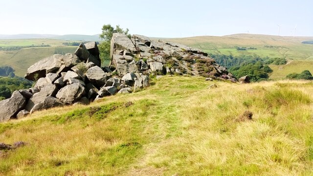
The moorland is characterized by its rugged terrain, covered in heather and grasses, interspersed with rocky outcrops and boulders. The name "Bride Stones" is derived from the large, weathered stones that dot the landscape, said to resemble a wedding party. These stones are believed to have been formed by natural erosion over millions of years.

The hill is a popular destination for hikers, nature enthusiasts, and outdoor adventurers. There are several well-marked footpaths and trails that lead visitors to the summit, providing an opportunity to witness the breathtaking scenery along the way. On clear days, it is possible to see as far as the Yorkshire Dales and the Manchester skyline.

Bride Stones Moor is also known for its rich biodiversity. The moorland supports a variety of plant and animal species, including heather, bilberry, golden plover, and curlew. It is a designated Site of Special Scientific Interest (SSSI) due to its importance for conservation.

Overall, Bride Stones Moor offers a tranquil and scenic escape for those seeking to explore the natural beauty of Yorkshire. Its unique geological features, stunning vistas, and abundant wildlife make it an ideal destination for outdoor enthusiasts and those looking to immerse themselves in nature.

If you have any feedback on the listing, please let us know in the comments section below.

Bride Stones Moor Images

Images are sourced within 2km of 53.736975/-2.1040801 or Grid Reference SD9326. Thanks to Geograph Open Source API. All images are credited.

Orchan Rocks Rocky outcrop.
Orchan Rocks
Rocky outcrop.
OS Bench Mark OS cut bench mark from the first, 19th century, levelling, on flat rock close to the trig point. There is no sign of a pivot or rivet. The BM is shown on the 1853 6" OS map but not on subsequent editions, nor on any 25" maps. Marked as 1434.7 feet above old datum
OS Bench Mark
OS cut bench mark from the first, 19th century, levelling, on flat rock close to the trig point. There is no sign of a pivot or rivet. The BM is shown on the 1853 6" OS map but not on subsequent editions, nor on any 25" maps. Marked as 1434.7 feet above old datum
Lydgate Railway Viaduct in 1994 The railway arch on the far left has since had strengthening work done to counter movement which had caused it to buckle. Knotts Naze towers above
Lydgate Railway Viaduct in 1994
The railway arch on the far left has since had strengthening work done to counter movement which had caused it to buckle. Knotts Naze towers above
Garages at Willow Bank An eclectic collection probably erected by individual householders at different times.
Garages at Willow Bank
An eclectic collection probably erected by individual householders at different times.
Hole Bottom Road, Todmorden The buildings in the photo are what remains of a larger complex shown on the 1907 map as 'Todmorden Laundry'. Is the circular structure the base of its chimney, and if so, when and why was a door inserted into it?
Hole Bottom Road, Todmorden
The buildings in the photo are what remains of a larger complex shown on the 1907 map as 'Todmorden Laundry'. Is the circular structure the base of its chimney, and if so, when and why was a door inserted into it?
Stansfield Cottages, Hole Bottom Road There is a lantern advertising Duvel beer above the door but I see no evidence that this was ever a pub so it's probably just someone's souvenir.
Stansfield Cottages, Hole Bottom Road
There is a lantern advertising Duvel beer above the door but I see no evidence that this was ever a pub so it's probably just someone's souvenir.
Bridleway at Hole Bottom
Cascade on Oak Hill Clough Not much water during a dry spring, but I expect this becomes a torrent after a downpour on the moors above.
Cascade on Oak Hill Clough
Not much water during a dry spring, but I expect this becomes a torrent after a downpour on the moors above.
Orange poppies by a footpath These look like Welsh poppies (Meconopsis cambrica), which are more commonly yellow.
Orange poppies by a footpath
These look like Welsh poppies (Meconopsis cambrica), which are more commonly yellow.
Bents Clough A narrow wooded clough above Todmorden, one of many draining the moors around the Bridestones.
Bents Clough
A narrow wooded clough above Todmorden, one of many draining the moors around the Bridestones.
Footpath junction in Bents Wood With a profusion of bluebells.
Footpath junction in Bents Wood
With a profusion of bluebells.
Footbridge below Latchford cottage This is a private bridge linking a house on one side of this stream to a garden on the other.  The track is a public footpath.
Footbridge below Latchford cottage
This is a private bridge linking a house on one side of this stream to a garden on the other. The track is a public footpath.
Track to Greenhurst Hey Most of the length of this track to the farm and beyond is surfaced with these upside-down concrete railway sleepers, a good choice as they will neither rot nor rut and are probably not very susceptible to frost damage. The track is a public footpath.
Track to Greenhurst Hey
Most of the length of this track to the farm and beyond is surfaced with these upside-down concrete railway sleepers, a good choice as they will neither rot nor rut and are probably not very susceptible to frost damage. The track is a public footpath.
Higher Wickenberry This pair of cottages with their stone mullioned windows looks as old as any in the area (probably 17th century) but is not listed. It was being renovated at the time of the photograph.
Higher Wickenberry
This pair of cottages with their stone mullioned windows looks as old as any in the area (probably 17th century) but is not listed. It was being renovated at the time of the photograph.
Black and white lambs Below Greenhurst Hey Farm.
Black and white lambs
Below Greenhurst Hey Farm.
Above Greenhurst Hey The farm commands a fine view over the upper Calder Valley although this was a dull day. Most of the length of this track to the farm and beyond is surfaced with these upside-down concrete railway sleepers, a good choice as they will neither rot nor rut and are probably not very susceptible to frost damage. The track is a public footpath.
Above Greenhurst Hey
The farm commands a fine view over the upper Calder Valley although this was a dull day. Most of the length of this track to the farm and beyond is surfaced with these upside-down concrete railway sleepers, a good choice as they will neither rot nor rut and are probably not very susceptible to frost damage. The track is a public footpath.
Bridleway below Windy Harbour Farm The track forms part of the Todmorden Centenary Way.
Bridleway below Windy Harbour Farm
The track forms part of the Todmorden Centenary Way.
The Wizard of Whirlaw An odd carving in the style of the Easter Island sculptures, by a stile alongside the Todmorden Centenary Way. At one time there was a 'junior' version alongside <a href="https://www.geograph.org.uk/photo/2878250">SD9326 : Scary face at Windy Harbour</a> that is no longer present.

Thanks to a local blogger Paul Knights, I found this is titled 'the Wizard of Whirlaw', carved by Mike Williams and inspired by the 1959 book of the same name by local author Billy Holt.
The Wizard of Whirlaw
An odd carving in the style of the Easter Island sculptures, by a stile alongside the Todmorden Centenary Way. At one time there was a 'junior' version alongside SD9326 : Scary face at Windy Harbour that is no longer present. Thanks to a local blogger Paul Knights, I found this is titled 'the Wizard of Whirlaw', carved by Mike Williams and inspired by the 1959 book of the same name by local author Billy Holt.
Show me another place!

Bride Stones Moor is located at Grid Ref: SD9326 (Lat: 53.736975, Lng: -2.1040801)

Division: West Riding

Unitary Authority: Calderdale

Police Authority: West Yorkshire

What 3 Words

///goodness.stud.barstool. Near Cornholme, West Yorkshire

Related Wikis

Mons Mill, Todmorden

Mons Mill, Todmorden, is a former cotton spinning mill in Todmorden, Calderdale, West Yorkshire, England built for the Hare Spinning Company Limited. It...

Blackshaw

Blackshaw is a civil parish in the Calderdale metropolitan borough of West Yorkshire, England. It contains the village of Blackshaw Head. According to...

Todmorden High School

Todmorden High School is a comprehensive school in the town of Todmorden, Calderdale LEA, West Yorkshire, England. == Admissions == Todmorden High School...

Cornholme railway station

Cornholme railway station served the village of Cornholme in West Yorkshire, England on the Copy Pit line. The station was opened by the Lancashire and...

Nearby Amenities

Located within 500m of 53.736975,-2.1040801
Bridestones
Ele: 438
Man Made: survey_point
Survey Point Structure: pillar
Lat/Long: 53.7369776/-2.1040062
The Bridestone (Bottleneck)
Natural: rock
Lat/Long: 53.7370204/-2.1026535
Barrier: stile
Lat/Long: 53.7363073/-2.1063251
Barrier: stile
Lat/Long: 53.7357221/-2.0981526
Barrier: stile
Foot: yes
Lat/Long: 53.7344193/-2.1101689
Golden Stones
Natural: rock
Lat/Long: 53.7351905/-2.1087359
Little Bride Stones
Natural: rock
Lat/Long: 53.7362338/-2.1009933
The data included in this document is from www.openstreetmap.org. The data is made available under ODbL.

Have you been to Bride Stones Moor?

Leave your review of Bride Stones Moor below (or comments, questions and feedback).