Tenter Hill
Hill, Mountain in Northumberland
England
Tenter Hill

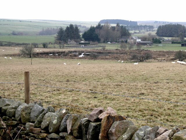
Tenter Hill is a prominent hill located in the county of Northumberland, England. Situated in the northern part of the county, it stands at an elevation of approximately 328 feet (100 meters) above sea level. The hill is part of the beautiful Northumberland National Park, renowned for its stunning landscapes and rich biodiversity.
Tenter Hill is characterized by its gently sloping terrain and its grassy, open summit. From the top, visitors are treated to breathtaking panoramic views of the surrounding countryside, including vast stretches of farmland and rolling hills. On clear days, it is even possible to catch a glimpse of the distant North Sea coastline.
The hill is a popular destination for outdoor enthusiasts, offering various recreational activities such as hiking and birdwatching. Several well-marked trails traverse the area, providing opportunities for both leisurely walks and more challenging hikes. The diverse flora and fauna found on Tenter Hill make it a haven for nature lovers, with an abundance of wildflowers, butterflies, and bird species to be observed.
Tenter Hill also holds historical significance, with evidence of ancient settlements and archaeological remains scattered throughout the surrounding landscape. It is not uncommon to stumble upon remnants of prehistoric structures or artifacts, testament to the area's rich history.
Overall, Tenter Hill is a captivating natural landmark that showcases the beauty of Northumberland. Its picturesque views, recreational opportunities, and historical significance make it a must-visit destination for locals and tourists alike.
If you have any feedback on the listing, please let us know in the comments section below.
Tenter Hill Images
Images are sourced within 2km of 54.916541/-2.1313201 or Grid Reference NY9157. Thanks to Geograph Open Source API. All images are credited.


Tenter Hill is located at Grid Ref: NY9157 (Lat: 54.916541, Lng: -2.1313201)
Unitary Authority: Northumberland
Police Authority: Northumbria
What 3 Words
///glares.disposal.chuckling. Near Hexham, Northumberland
Nearby Locations
Related Wikis

Whitley Chapel
Whitley Chapel is a village in Northumberland, England about 4 miles (6 km) south of Hexham, and in the parish of Hexhamshire. == Governance == Whitley...

Hexhamshire
Hexhamshire is a civil parish in Northern England. It was incorporated into Northumberland in 1572. == History == Hexhamshire was originally a single parish...

Juniper, Northumberland
Juniper is a hamlet in the English county of Northumberland. It is about 5 miles (8 km) due south of Hexham in the area known as Hexhamshire. There is...
Hexhamshire Low Quarter
Hexhamshire Low Quarter is a former civil parish, now in the parish of Hexhamshire, in Northumberland, England. It was situated to the south of Hexham...

Rowley Burn (Northumberland)
Rowley Burn (also known as Rowley Brook and Ham Burn, NY 9358) is a stream in Northumberland, running around three miles south of Hexham before joining...
St Joseph's Roman Catholic Middle School
St Joseph's Roman Catholic Middle School is one of the two middle schools in Hexham, Northumberland, England, the other being Hexham Middle School. The...
Queen Elizabeth High School, Hexham
Queen Elizabeth High School (QEHS) is a coeducational high school and sixth form located in Hexham, Northumberland, England. == History == The school was...

Slaley, Northumberland
Slaley is a village in Northumberland, England. It is situated to the southeast of Hexham. It is surrounded by the following villages: Ruffside, Whitley...
Nearby Amenities
Located within 500m of 54.916541,-2.1313201Have you been to Tenter Hill?
Leave your review of Tenter Hill below (or comments, questions and feedback).