How Top

Hill, Mountain in Yorkshire

England

How Top

Wall and fence east of Green Fell A fence has run along the ridge line east-south-east from Green Fell to this point where a wall continues in the same direction. Unusually, from the same point there's a parallel fence close to the wall, some two or three metres from it. The fence was clearly put in place long after the wall and the wall is in good condition.  The fence has been erected for some reason; it's hard to fathom what.
Wall and fence east of Green Fell Credit: Trevor Littlewood

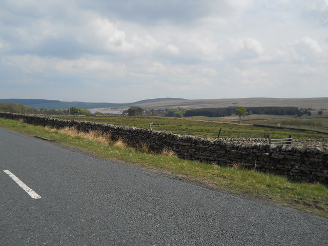
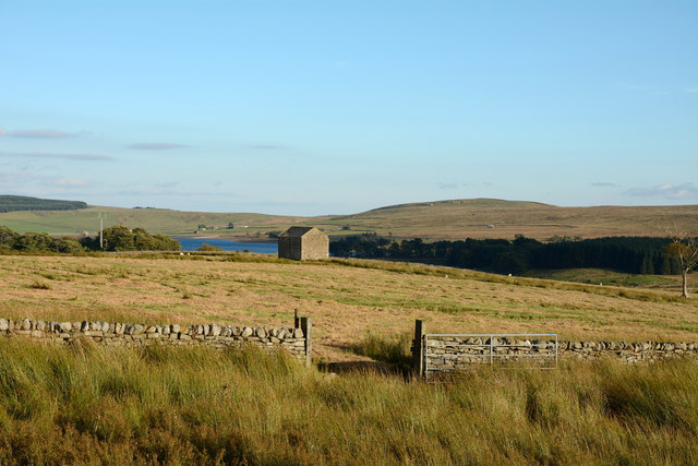
Top, Yorkshire is a prominent hill located in the county of Yorkshire, England. Rising to an elevation of approximately 1,000 feet (300 meters), it is considered one of the highest points in the region. Situated in the picturesque countryside, the hill offers breathtaking views of the surrounding landscape.

Top, Yorkshire is characterized by its distinctive shape, with a gradual slope leading up to a rounded summit. The hill is covered in lush green vegetation, including grasses, shrubs, and occasional patches of woodland. The terrain is relatively gentle, making it accessible for hikers and nature enthusiasts of all ages.

The summit of Top, Yorkshire provides an ideal vantage point for observing the surrounding countryside. On clear days, visitors can enjoy panoramic views of the rolling hills, valleys, and distant villages that dot the landscape. The hill is particularly popular during sunrise and sunset, as the changing colors in the sky add to the beauty of the scenery.

Wildlife is abundant in the area surrounding Top, Yorkshire. Birdwatchers can spot various species of birds, including kestrels, buzzards, and pheasants. Additionally, the hill is home to small mammals like rabbits, hares, and foxes.

Visitors to Top, Yorkshire can explore the hill through a network of footpaths and trails that crisscross the area. These paths provide opportunities for leisurely walks, challenging hikes, or even mountain biking. The hill is well-maintained, with signage and maps available to ensure safe navigation.

Overall, Top, Yorkshire is a stunning natural landmark that offers a serene and scenic experience for those who venture to its heights.

If you have any feedback on the listing, please let us know in the comments section below.

How Top Images

Images are sourced within 2km of 54.602746/-2.1498725 or Grid Reference NY9023. Thanks to Geograph Open Source API. All images are credited.

Wall and fence east of Green Fell A fence has run along the ridge line east-south-east from Green Fell to this point where a wall continues in the same direction. Unusually, from the same point there's a parallel fence close to the wall, some two or three metres from it. The fence was clearly put in place long after the wall and the wall is in good condition.  The fence has been erected for some reason; it's hard to fathom what.
Wall and fence east of Green Fell
A fence has run along the ridge line east-south-east from Green Fell to this point where a wall continues in the same direction. Unusually, from the same point there's a parallel fence close to the wall, some two or three metres from it. The fence was clearly put in place long after the wall and the wall is in good condition. The fence has been erected for some reason; it's hard to fathom what.
A view of Selset Reservoir
Tarn on Green Fell
Tarn on Green Fell
Grouse Butts on Cocklake
Upper Wemmergill Beck Sheepfolds by the beck
Upper Wemmergill Beck
Sheepfolds by the beck
Barn, wall and rough grazing north of Selset Reservoir Selset Reservoir which is seen distantly in the image extends unseen below the enclosures seen in this image. The wall with a gateway seems not to be shown on OS mapping but it does exist and can be seen clearly on Google Earth imaging.
Barn, wall and rough grazing north of Selset Reservoir
Selset Reservoir which is seen distantly in the image extends unseen below the enclosures seen in this image. The wall with a gateway seems not to be shown on OS mapping but it does exist and can be seen clearly on Google Earth imaging.
Valley of Wemmergill Beck Wemmergill Beck and its tributaries drain Lune Moor, a name given more prominence on OS maps at 1:50 000 than at larger scales. White tubes such as the one among rocks in the foreground are used by gamekeepers to mark positions where they lay trays of grit for grouse.
Valley of Wemmergill Beck
Wemmergill Beck and its tributaries drain Lune Moor, a name given more prominence on OS maps at 1:50 000 than at larger scales. White tubes such as the one among rocks in the foreground are used by gamekeepers to mark positions where they lay trays of grit for grouse.
Valley of Wemmergill Beck Wemmergill Beck and its tributaries drain the ground east of Bink Moss.
Valley of Wemmergill Beck
Wemmergill Beck and its tributaries drain the ground east of Bink Moss.
Gate The track to the barn was very indistinct making you wonder if the barn was still used
Gate
The track to the barn was very indistinct making you wonder if the barn was still used
Cock Lake
Cock Lake
Wemmergill Beck Looking down to where it enters High Plantation.
Wemmergill Beck
Looking down to where it enters High Plantation.
Wemmergill Beck Looking up the valley of the burn as it descends from Lune Moor.
Wemmergill Beck
Looking up the valley of the burn as it descends from Lune Moor.
Wemmergill Beck The beck as it enters High Plantation.
Wemmergill Beck
The beck as it enters High Plantation.
Wemmergill Beck An old sheepfold and mine building either side of the beck which can be seen cascading behind.
Wemmergill Beck
An old sheepfold and mine building either side of the beck which can be seen cascading behind.
Wemmergill Beck Looking downstream beside the two old sheepfolds.
Wemmergill Beck
Looking downstream beside the two old sheepfolds.
Lune Moor Looking across the valley of Wemmergill Beck to Scarset Rigg and How Top.
Lune Moor
Looking across the valley of Wemmergill Beck to Scarset Rigg and How Top.
Cairn on Lune Moor Bink Moss rises in the background.
Cairn on Lune Moor
Bink Moss rises in the background.
Lune Moor Vegetation is a mixture of heather, burnt and unburnt, and grass. An old sheepfold is just about visible in the middle distance.
Lune Moor
Vegetation is a mixture of heather, burnt and unburnt, and grass. An old sheepfold is just about visible in the middle distance.
Show me another place!

How Top is located at Grid Ref: NY9023 (Lat: 54.602746, Lng: -2.1498725)

Division: North Riding

Unitary Authority: County Durham

Police Authority: Durham

What 3 Words

///spectacle.gullible.convey. Near Holwick, Co. Durham

Related Wikis

Selset Reservoir

Selset Reservoir is a reservoir in County Durham, England. It is situated in Lunedale which is a side valley of the River Tees, about 5 miles (8 km) west...

Harter Fell, Lunedale

Harter Fell is an area of upland heath in west County Durham, England. It lies on the watershed between the River Tees to the north-east and the River...

Grassholme

Grassholme is a village in County Durham, England.For centuries it lay within the historic county boundaries of the North Riding of Yorkshire, but, along...

Thringarth

Thringarth is a hamlet in Lunedale, in the Pennines of England. It is traditionally located in the North Riding of Yorkshire but along with the rest of...

Rigg Farm and Stake Hill Meadows

Rigg Farm and Stake Hill Meadows is a Site of Special Scientific Interest in the Teesdale district of County Durham, England. It is situated in Lunedale...

Grassholme Reservoir

Grassholme Reservoir is a large reservoir in County Durham, England. It is situated in Lunedale, which is a side valley of the River Tees, about 2 miles...

Kirkcarrion

Kirkcarrion is a copse of pine trees, surrounded by a stone wall, on a hilltop near Middleton-in-Teesdale, County Durham, England. The trees, which were...

Park End Wood

Park End Wood is a Site of Special Scientific Interest in the Teesdale district of west County Durham, England. The site occupies a low hill of Whin Sill...

Nearby Amenities

Located within 500m of 54.602746,-2.1498725
How Top
Natural: peak
Source: npe
Source Name: OS_OpenData_StreetView
Lat/Long: 54.6029102/-2.1499245
Lune Moor
Natural: heath
Lat/Long: 54.6061718/-2.1530295
Black Hill
Natural: peak
Source: OS OpenData StreetView
Lat/Long: 54.598565/-2.1521712
Archaeological Site: mineral_extraction
Historic: mine_shaft
Note: OS map annotation not clear - appears to be 1 of 3
Source: NLS-OS-NatGrid-110k-1940-60
Lat/Long: 54.6038401/-2.1508776
How Side
Natural: fell
Source: NLS-OS-NatGrid-110k-1940-60
Lat/Long: 54.5998875/-2.154137
Archaeological Site: mineral_extraction
Historic: mine_shaft
Note: OS map annotation not clear - appears to be 1 of 3
Source: NLS-OS-NatGrid-110k-1940-60
Lat/Long: 54.6041148/-2.1543087
Natural: spring
Source: NLS-OS-NatGrid-110k-1940-60
Lat/Long: 54.6031584/-2.1446302
Archaeological Site: mineral_extraction
Historic: mine_shaft
Note: OS map annotation not clear - appears to be 1 of 3
Source: NLS-OS-NatGrid-110k-1940-60
Lat/Long: 54.6035418/-2.1488176
Man Made: cairn
Lat/Long: 54.602906/-2.149984
The data included in this document is from www.openstreetmap.org. The data is made available under ODbL.

Have you been to How Top?

Leave your review of How Top below (or comments, questions and feedback).