Riffington Hill

Hill, Mountain in Northumberland

England

Riffington Hill

Stubble field near Shellacres Farm
Stubble field near Shellacres Farm Credit: Walter Baxter

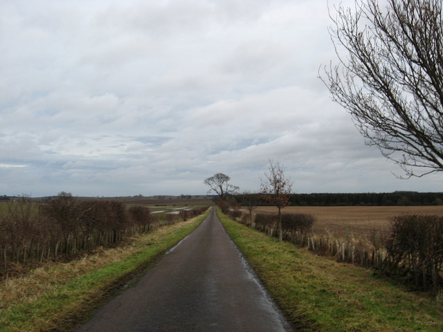
Riffington Hill is a prominent hill located in the county of Northumberland, England. It is part of the larger Cheviot Hills range, which stretches across the border between England and Scotland. Riffington Hill stands at an elevation of approximately 500 meters (1,640 feet) above sea level, making it one of the highest points in the area.

The hill is primarily composed of sedimentary rocks, such as sandstone and limestone, which were formed over millions of years. Its slopes are covered in lush green vegetation, including heather, grasses, and scattered trees, providing a picturesque view of the surrounding countryside.

Riffington Hill offers breathtaking panoramic views of the Northumberland National Park and the nearby Scottish Borders. On a clear day, it is possible to see as far as the North Sea to the east and the Cheviot Hills to the west. The hill is a popular destination for hikers and nature enthusiasts, who are drawn to its natural beauty and tranquility.

The area surrounding Riffington Hill is rich in wildlife, with various species of birds, mammals, and plants calling it home. It is not uncommon to spot red deer, foxes, and various bird species, including buzzards and ravens, while exploring the hill.

Access to Riffington Hill is relatively easy, with several footpaths and trails leading to its summit. The hill offers a challenging but rewarding climb, with stunning views awaiting those who reach the top. Whether it is to enjoy a peaceful walk, admire the beautiful landscape, or engage in outdoor activities, Riffington Hill is a must-visit destination for nature lovers in Northumberland.

If you have any feedback on the listing, please let us know in the comments section below.

Riffington Hill Images

Images are sourced within 2km of 55.692681/-2.1812709 or Grid Reference NT8844. Thanks to Geograph Open Source API. All images are credited.

Stubble field near Shellacres Farm
The A698 heading to Cornhill Near Wideopen Plantation.
The A698 heading to Cornhill
Near Wideopen Plantation.
Country road heading for Westmoor Plantation In north Northumberland.
Country road heading for Westmoor Plantation
In north Northumberland.
Two Little Egrets in the Tweed Two of a total of three Little Egrets in the River Tweed near Upsettlington.  All three birds were originally encountered feeding in shallows by Bendibus Island; they later relocated to the Scottish side of the river where I captured this shot.

This photograph was taken during the Coronavirus (COVID-19) pandemic of 2020/21.
Two Little Egrets in the Tweed
Two of a total of three Little Egrets in the River Tweed near Upsettlington. All three birds were originally encountered feeding in shallows by Bendibus Island; they later relocated to the Scottish side of the river where I captured this shot. This photograph was taken during the Coronavirus (COVID-19) pandemic of 2020/21.
Three Little Egrets in the Tweed All three birds were originally encountered feeding in shallows by Bendibus Island; they later relocated to the Scottish side of the river where I captured this shot.

Little Egrets are now encountered occasionally on the River Tweed and adjacent areas.  I have had two birds near this location in the past, and a solitary individual further downstream opposite the mouth of the Horndean Burn.  In January 2021, an individual was recorded on the Leet Water upstream of Leitholm.

This photograph was taken during the Coronavirus (COVID-19) pandemic of 2020/21.
Three Little Egrets in the Tweed
All three birds were originally encountered feeding in shallows by Bendibus Island; they later relocated to the Scottish side of the river where I captured this shot. Little Egrets are now encountered occasionally on the River Tweed and adjacent areas. I have had two birds near this location in the past, and a solitary individual further downstream opposite the mouth of the Horndean Burn. In January 2021, an individual was recorded on the Leet Water upstream of Leitholm. This photograph was taken during the Coronavirus (COVID-19) pandemic of 2020/21.
Cleared forestry by the River Tweed This section of forestry was badly damaged in Storm Arwen (26/27 November 2021) and is in the process of being felled.  

This photograph was taken during the Coronavirus (COVID-19) pandemic of 2020/21/22.
Cleared forestry by the River Tweed
This section of forestry was badly damaged in Storm Arwen (26/27 November 2021) and is in the process of being felled. This photograph was taken during the Coronavirus (COVID-19) pandemic of 2020/21/22.
Late afternoon by the Tweed Having negotiated casualties of Storm Arwen (26/27 November 2021) the walk along the southern bank of the River Tweed continues.  A wrecked fishing shiel, again another casualty of Storm Arwen, can be seen on the opposite bank and the silos of West Newbiggin Farm can be noted in the distance.

This photograph was taken during the Coronavirus (COVID-19) pandemic of 2020/21/22.
Late afternoon by the Tweed
Having negotiated casualties of Storm Arwen (26/27 November 2021) the walk along the southern bank of the River Tweed continues. A wrecked fishing shiel, again another casualty of Storm Arwen, can be seen on the opposite bank and the silos of West Newbiggin Farm can be noted in the distance. This photograph was taken during the Coronavirus (COVID-19) pandemic of 2020/21/22.
By the breakwater at sunset The River Tweed is a little higher than normal, swollen by recent rains.  The breakwater is clearly seen directing the current away from the narrow passage outside the boundary wall of Ladykirk Estate.  For an alternative view of the breakwater during a lower water level, see <a href="https://www.geograph.org.uk/photo/5253306">NT8845 : A Breakwater In The River Tweed</a>

This photograph was taken during the Coronavirus (COVID-19) pandemic of 2020/21/22.
By the breakwater at sunset
The River Tweed is a little higher than normal, swollen by recent rains. The breakwater is clearly seen directing the current away from the narrow passage outside the boundary wall of Ladykirk Estate. For an alternative view of the breakwater during a lower water level, see NT8845 : A Breakwater In The River Tweed This photograph was taken during the Coronavirus (COVID-19) pandemic of 2020/21/22.
A late afternoon shower is imminent Darkening skies are the prelude to a rain shower over the River Tweed by Ladykirk Estate.

This photograph was taken during the Coronavirus (COVID-19) pandemic of 2020/21/22.
A late afternoon shower is imminent
Darkening skies are the prelude to a rain shower over the River Tweed by Ladykirk Estate. This photograph was taken during the Coronavirus (COVID-19) pandemic of 2020/21/22.
A fishing shiel destroyed by Storm Arwen Downstream from Bendibus Shiel, this corrugated metal shiel which sat on wood and concrete, has been destroyed by Storm Arwen (26/27 November 2021).

This photograph was taken during the Coronavirus (COVID-19) pandemic of 2020/21/22.
A fishing shiel destroyed by Storm Arwen
Downstream from Bendibus Shiel, this corrugated metal shiel which sat on wood and concrete, has been destroyed by Storm Arwen (26/27 November 2021). This photograph was taken during the Coronavirus (COVID-19) pandemic of 2020/21/22.
Between the log piles The Tweedside track with evidence of recent timber extraction, hastened by the effects of Storm Arwen  (26/27 November 2021).

This photograph was taken during the Coronavirus (COVID-19) pandemic of 2020/21/22.
Between the log piles
The Tweedside track with evidence of recent timber extraction, hastened by the effects of Storm Arwen (26/27 November 2021). This photograph was taken during the Coronavirus (COVID-19) pandemic of 2020/21/22.
A glorious July morning by the River Tweed Beautiful conditions by the River Tweed opposite Bendibus Island.

This photograph was taken during the Coronavirus (COVID-19) pandemic of 2020/21/22.
A glorious July morning by the River Tweed
Beautiful conditions by the River Tweed opposite Bendibus Island. This photograph was taken during the Coronavirus (COVID-19) pandemic of 2020/21/22.
Completed tree harvesting operations by the Tweed Further to devastation caused by Storm Arwen on 26/27 November 2021, this small plantation has been felled in the first half of 2022.  Some lumber is stacked awaiting collection.

This photograph was taken during the Coronavirus (COVID-19) pandemic of 2020/21/22.
Completed tree harvesting operations by the Tweed
Further to devastation caused by Storm Arwen on 26/27 November 2021, this small plantation has been felled in the first half of 2022. Some lumber is stacked awaiting collection. This photograph was taken during the Coronavirus (COVID-19) pandemic of 2020/21/22.
View  from  our  holiday  cottage  on  the  Milne  Graden  Estate Early morning over the River Tweed. If you wished, the riverside footpath takes you left to Norham Bridge or right to Coldstream. The south bank bathed in sunlight is in Northumberland, The border is the middle of the river.
View from our holiday cottage on the Milne Graden Estate
Early morning over the River Tweed. If you wished, the riverside footpath takes you left to Norham Bridge or right to Coldstream. The south bank bathed in sunlight is in Northumberland, The border is the middle of the river.
Track  up  from  River  Tweed  toward  Sunnyside The track goes from the riverbank through the wood and joins the estate road which takes you out onto the B6437 at North Lodge. The buildings in the trees (centre) are shown on the map as Sunnyside, former estate workers homes and school they are now four holiday lets, beloved of salmon/trout fishermen.
Track up from River Tweed toward Sunnyside
The track goes from the riverbank through the wood and joins the estate road which takes you out onto the B6437 at North Lodge. The buildings in the trees (centre) are shown on the map as Sunnyside, former estate workers homes and school they are now four holiday lets, beloved of salmon/trout fishermen.
Damford  Shiel.  River  Tweed  Milne  Graden  Estate The salmon fishermen park their vehicles here, and boats are moored on the river, equipment is housed in the shiel.
Damford Shiel. River Tweed Milne Graden Estate
The salmon fishermen park their vehicles here, and boats are moored on the river, equipment is housed in the shiel.
Tweedside  walk,  footbridge  over  Bannock  Burn A walk before breakfast alongside the Tweed
Tweedside walk, footbridge over Bannock Burn
A walk before breakfast alongside the Tweed
Swan  family  on  the  River  Tweed Heading upstream, the river discoloured due to heavy rain
Swan family on the River Tweed
Heading upstream, the river discoloured due to heavy rain
Show me another place!

Riffington Hill is located at Grid Ref: NT8844 (Lat: 55.692681, Lng: -2.1812709)

Unitary Authority: Northumberland

Police Authority: Northumbria

What 3 Words

///trapdoor.snows.described. Near Coldstream, Scottish Borders

Related Wikis

Twizell Castle

Twizell Castle (also spelt Twizel) is a Grade II* listed building and a Scheduled Ancient Monument which stands on a bend of the River Till at Tillmouth...

Twizell railway station

Twizell railway station served the historic village of Twizell, Northumberland, England, from 1861 to 1955 on the Kelso Branch. == History == The station...

River Till, Northumberland

The River Till is a river of north-eastern Northumberland. It is a tributary of the River Tweed, of which it is the only major tributary to flow wholly...

Ladykirk, Scottish Borders

Ladykirk is a village on the B6470 in the Scottish Borders area of Scotland, and the former Berwickshire, just north of the River Tweed and the Anglo...

Related Videos

Parish Church And Graveyard On Visit To Ladykirk In The Borders Of Scotland

Tour Scotland travel video clip, with Scottish music, of the parish church and graveyard on visit to Ladykirk in the Scottish Borders.

Interior Of Parish Church With Music On History Visit To Ladykirk Borders Scotland

Tour Scotland short 4K travel video clip, with Scottish music, of the interior of the Parish Church on ancestry, genealogy, family ...

Nearby Amenities

Located within 500m of 55.692681,-2.1812709
Riffington
Place: hamlet
Lat/Long: 55.6929372/-2.1771291
Riffington Hill
Place: locality
Lat/Long: 55.6929263/-2.1825636
Power: pole
Lat/Long: 55.6921178/-2.1883392
Power: pole
Lat/Long: 55.6928109/-2.1870987
Power: pole
Lat/Long: 55.6937059/-2.1852238
Power: pole
Lat/Long: 55.6941428/-2.1842998
Power: pole
Lat/Long: 55.6946613/-2.1832135
Power: pole
Lat/Long: 55.6951692/-2.1821567
Power: pole
Lat/Long: 55.6956817/-2.1810624
Power: pole
Lat/Long: 55.696173/-2.1800244
Power: pole
Lat/Long: 55.6967141/-2.1788979
The data included in this document is from www.openstreetmap.org. The data is made available under ODbL.

Have you been to Riffington Hill?

Leave your review of Riffington Hill below (or comments, questions and feedback).