Race Head

Hill, Mountain in Durham

England

Race Head

Grazing pasture at Newhouse Pastures This is an area of level pasture adjacent to the Weardale Way.
Grazing pasture at Newhouse Pastures Credit: Clive Nicholson

Race Head is a prominent hill located in Durham, England. Situated in the eastern part of the county, it forms part of the North Pennines Area of Outstanding Natural Beauty. The hill stands at an elevation of approximately 427 meters (1,401 feet) above sea level, making it one of the highest points in the region.

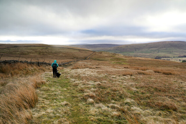
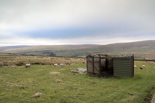
Race Head is characterized by its distinctive conical shape, offering breathtaking panoramic views of the surrounding landscape. From its summit, visitors can admire the rolling hills, valleys, and moorland that stretch out in every direction. On clear days, it is even possible to catch a glimpse of the distant North Sea.

The site is a popular destination for hikers, nature enthusiasts, and outdoor adventurers alike. Several footpaths and trails crisscross the hill, allowing visitors to explore its diverse flora and fauna. The hill is home to a variety of bird species, including curlews, lapwings, and red grouse.

Race Head is also steeped in history, with evidence of human activity dating back thousands of years. Archaeological remains, such as Bronze Age burial mounds and Iron Age hillforts, can be found in the vicinity, adding to the hill's cultural significance.

Overall, Race Head offers a unique and picturesque experience for those seeking natural beauty and a glimpse into the region's rich history. Whether it be for a leisurely walk, a challenging hike, or simply to appreciate the stunning views, Race Head is a must-visit destination in Durham.

If you have any feedback on the listing, please let us know in the comments section below.

Race Head Images

Images are sourced within 2km of 54.759435/-2.1896422 or Grid Reference NY8740. Thanks to Geograph Open Source API. All images are credited.

Grazing pasture at Newhouse Pastures This is an area of level pasture adjacent to the Weardale Way.
Grazing pasture at Newhouse Pastures
This is an area of level pasture adjacent to the Weardale Way.
Bridleway over Carr Brow Moor From Middlehope Bank (the minor road from Rookhope to Ireshopeburn) the bridleway gives good walking down towards Levelgate Sike and up over the shoulder of Bleak Laws on Carr Brow Moor. Just beyond the horizon, it passes through a gate and becomes a more substantial track, rather cut up by big tractor tyres, making the descent into Weardale a bit more wearing than the pleasant going on the moor.
Bridleway over Carr Brow Moor
From Middlehope Bank (the minor road from Rookhope to Ireshopeburn) the bridleway gives good walking down towards Levelgate Sike and up over the shoulder of Bleak Laws on Carr Brow Moor. Just beyond the horizon, it passes through a gate and becomes a more substantial track, rather cut up by big tractor tyres, making the descent into Weardale a bit more wearing than the pleasant going on the moor.
Not much shelter left This disused railway goods van shell has been here long enough to be mapped by the OS, but in that time, the weather has done it no good at all. With parts of the roof falling in, and part blown off, it may provide shelter from the wind for a few sheep, but certainly won't keep the rain or snow off. One panel seems to have been replaced by corrugated iron, but it looks as though the owner has decided that further repair is pointless. One hopes that on its final demise, it is removed and metal parts suitably recycled, not left here to rust and rot away completely.
Not much shelter left
This disused railway goods van shell has been here long enough to be mapped by the OS, but in that time, the weather has done it no good at all. With parts of the roof falling in, and part blown off, it may provide shelter from the wind for a few sheep, but certainly won't keep the rain or snow off. One panel seems to have been replaced by corrugated iron, but it looks as though the owner has decided that further repair is pointless. One hopes that on its final demise, it is removed and metal parts suitably recycled, not left here to rust and rot away completely.
River Wear near Waterside Farm
Newfield The property at Newfield seen along its access road high on the northern side of Weardale.
Newfield
The property at Newfield seen along its access road high on the northern side of Weardale.
Trees on grazing land at West Blackdene Several deciduous trees in the field which has rough grazing; it's south of a minor road in Weardale.
Chapel Fell is the moorland hill in the distance.
Trees on grazing land at West Blackdene
Several deciduous trees in the field which has rough grazing; it's south of a minor road in Weardale. Chapel Fell is the moorland hill in the distance.
Trees in valley of Elmford Cleugh Elmford Cleugh is a tributary of the River Wear descending on the north side of the valley.
Trees in valley of Elmford Cleugh
Elmford Cleugh is a tributary of the River Wear descending on the north side of the valley.
West Blackdene Small community near Ireshopeburn in Weardale
West Blackdene
Small community near Ireshopeburn in Weardale
River Wear at West Blackdene The Weardale Way crosses the river at this point, to reach West Blackdene
River Wear at West Blackdene
The Weardale Way crosses the river at this point, to reach West Blackdene
On the Weardale Way opposite Iresburnhope The long distance footpath on the banks of the Wear, opposite the small village of Iresburnhope
On the Weardale Way opposite Iresburnhope
The long distance footpath on the banks of the Wear, opposite the small village of Iresburnhope
Newhouse Pasture Green pasture on the valley floor of Weardale
Newhouse Pasture
Green pasture on the valley floor of Weardale
Footbridge across the River Wear A 77 mile route following the River Wear from the sea at the Lindesfarne Memorial, Sunderland to the headwaters in the east Pennines, keeping as close as is possible to the river. It visits Lumley Castle, Durham (where the Castle and Cathedral forms a World Heritage Site), Bishop Auckland and Stanhope. After Stanhope the Way makes a northward loop to Rookhope to take in part of a tributary, Rookhope Burn.
Footbridge across the River Wear
A 77 mile route following the River Wear from the sea at the Lindesfarne Memorial, Sunderland to the headwaters in the east Pennines, keeping as close as is possible to the river. It visits Lumley Castle, Durham (where the Castle and Cathedral forms a World Heritage Site), Bishop Auckland and Stanhope. After Stanhope the Way makes a northward loop to Rookhope to take in part of a tributary, Rookhope Burn.
The Weardale Way crossing the Wear to West Blackdene A 77 mile route following the River Wear from the sea at the Lindesfarne Memorial, Sunderland to the headwaters in the east Pennines, keeping as close as is possible to the river. It visits Lumley Castle, Durham (where the Castle and Cathedral forms a World Heritage Site), Bishop Auckland and Stanhope. After Stanhope the Way makes a northward loop to Rookhope to take in part of a tributary, Rookhope Burn.
The Weardale Way crossing the Wear to West Blackdene
A 77 mile route following the River Wear from the sea at the Lindesfarne Memorial, Sunderland to the headwaters in the east Pennines, keeping as close as is possible to the river. It visits Lumley Castle, Durham (where the Castle and Cathedral forms a World Heritage Site), Bishop Auckland and Stanhope. After Stanhope the Way makes a northward loop to Rookhope to take in part of a tributary, Rookhope Burn.
Anita's Way crossing the River Wear A relatively modern bridge. Why was it built?
Anita's Way crossing the River Wear
A relatively modern bridge. Why was it built?
The Weardale Way by the Wear at Ireshopeburn A 77 mile route following the River Wear from the sea at the Lindesfarne Memorial, Sunderland to the headwaters in the east Pennines, keeping as close as is possible to the river. It visits Lumley Castle, Durham (where the Castle and Cathedral forms a World Heritage Site), Bishop Auckland and Stanhope. After Stanhope the Way makes a northward loop to Rookhope to take in part of a tributary, Rookhope Burn.
The Weardale Way by the Wear at Ireshopeburn
A 77 mile route following the River Wear from the sea at the Lindesfarne Memorial, Sunderland to the headwaters in the east Pennines, keeping as close as is possible to the river. It visits Lumley Castle, Durham (where the Castle and Cathedral forms a World Heritage Site), Bishop Auckland and Stanhope. After Stanhope the Way makes a northward loop to Rookhope to take in part of a tributary, Rookhope Burn.
The River Wear at Pennine Lodge The flat bed of Carboniferous limestone (Alston Formation) which extends behind the waterfall acts as a ford
The River Wear at Pennine Lodge
The flat bed of Carboniferous limestone (Alston Formation) which extends behind the waterfall acts as a ford
Lime kiln north of New House
Lime kiln north of New House - arch See <a href="https://www.geograph.org.uk/photo/7239353">NY8739 : Lime kiln north of New House</a>.
Lime kiln north of New House - arch
Show me another place!

Race Head is located at Grid Ref: NY8740 (Lat: 54.759435, Lng: -2.1896422)

Unitary Authority: County Durham

Police Authority: Durham

What 3 Words

///shin.blemishes.entire. Near Stanhope, Co. Durham

Related Wikis

West Blackdene

West Blackdene is a village in the civil parish of Stanhope, in County Durham, England. It is situated to the north of the River Wear, opposite Ireshopeburn...

East Blackdene

East Blackdene is a hamlet in the civil parish of Stanhope, in County Durham, England. It is situated to the north of the River Wear, on the opposite side...

Wearhead railway station

Wearhead railway station served the village of Wearhead, County Durham, England, from 1895 to 1961 on the Weardale Railway. == History == The station opened...

Ireshopeburn

Ireshopeburn ( EYE-sup-burn ) is a village in the civil parish of Stanhope, in County Durham, England. It is situated on the south side of Weardale, between...

Nearby Amenities

Located within 500m of 54.759435,-2.1896422
Barrier: entrance
Lat/Long: 54.7609604/-2.1927554
The data included in this document is from www.openstreetmap.org. The data is made available under ODbL.

Have you been to Race Head?

Leave your review of Race Head below (or comments, questions and feedback).