Hill of Mahuncar

Hill, Mountain in Aberdeenshire

Scotland

Hill of Mahuncar

Minor road near Corthie Moss
Minor road near Corthie Moss Credit: Steven Brown

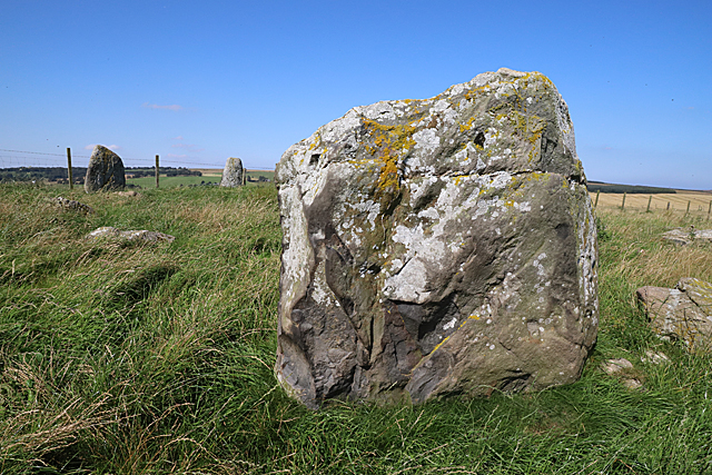
The Hill of Mahuncar is a prominent landmark located in Aberdeenshire, Scotland. Rising to an elevation of approximately 377 meters (1,237 feet), it is a notable hill in the region. Situated in the eastern part of Aberdeenshire, near the village of Strachan, the Hill of Mahuncar offers breathtaking panoramic views of the surrounding countryside.

Covered in lush green vegetation, the hill is characterized by its gently sloping sides and a distinctive rocky summit. It is part of the Grampian Mountains, which stretch across the eastern part of Scotland. The hill is formed from granite and quartzite rocks, adding to its rugged beauty.

The area surrounding the Hill of Mahuncar is rich in biodiversity, with a variety of plant and animal species thriving in its diverse habitats. Hikers and nature enthusiasts often explore its slopes, taking in the sights and sounds of the Scottish countryside. The hill is also a popular spot for birdwatching, with various species of birds, including peregrine falcons and golden eagles, often spotted soaring above.

Access to the Hill of Mahuncar is relatively easy, with several well-marked trails leading to its summit. A visit to the hill provides an opportunity to experience the tranquility of the Scottish Highlands and immerse oneself in its natural beauty.

Overall, the Hill of Mahuncar in Aberdeenshire is a remarkable geological formation, offering visitors a chance to appreciate Scotland's stunning landscapes and enjoy outdoor activities in a picturesque setting.

If you have any feedback on the listing, please let us know in the comments section below.

Hill of Mahuncar Images

Images are sourced within 2km of 57.589121/-2.2523507 or Grid Reference NJ8555. Thanks to Geograph Open Source API. All images are credited.

Minor road near Corthie Moss
Minor road near Hillock O'Leys
Farm track near New Pitsligo
Minor road near Cowbog
Farm road to March Farm
Moorland, Todholes An expanse of low altitude heather.
Moorland, Todholes
An expanse of low altitude heather.
Lovie Limited This company makes concrete and quarry products. In the office car park are displays of samples of their products.
Lovie Limited
This company makes concrete and quarry products. In the office car park are displays of samples of their products.
Upper Auchnagorth Stone Circle (1) There are ten stones in this circle, three of which are still erect. A fence runs close to two of these, which rather spoils the effect. See <span class="nowrap"><a title="https://canmore.org.uk/site/19926/upper-auchnagorth" rel="nofollow ugc noopener" href="https://canmore.org.uk/site/19926/upper-auchnagorth">Link</a><img style="margin-left:2px;" alt="External link" title="External link - shift click to open in new window" src="https://s1.geograph.org.uk/img/external.png" width="10" height="10"/></span> for more details. <a href="https://www.geograph.org.uk/photo/6251863">NJ8356 : Upper Auchnagorth Stone Circle (2)</a>
Upper Auchnagorth Stone Circle (1)
There are ten stones in this circle, three of which are still erect. A fence runs close to two of these, which rather spoils the effect. See LinkExternal link for more details. NJ8356 : Upper Auchnagorth Stone Circle (2)
Upper Auchnagorth Stone Circle (2) There are ten stones in this circle, three of which are still erect. In this view the largest stone is closest to the camera. See <span class="nowrap"><a title="https://canmore.org.uk/site/19926/upper-auchnagorth" rel="nofollow ugc noopener" href="https://canmore.org.uk/site/19926/upper-auchnagorth">Link</a><img style="margin-left:2px;" alt="External link" title="External link - shift click to open in new window" src="https://s1.geograph.org.uk/img/external.png" width="10" height="10"/></span> for more details. <a href="https://www.geograph.org.uk/photo/6251864">NJ8356 : Upper Auchnagorth Stone Circle (3)</a>
Upper Auchnagorth Stone Circle (2)
There are ten stones in this circle, three of which are still erect. In this view the largest stone is closest to the camera. See LinkExternal link for more details. NJ8356 : Upper Auchnagorth Stone Circle (3)
Upper Auchnagorth Stone Circle (3) There are ten stones in this circle, three of which are still erect. This is largest stone, which fortunately is large enough to hide a rather unappealing concrete building in the background! See <span class="nowrap"><a title="https://canmore.org.uk/site/19926/upper-auchnagorth" rel="nofollow ugc noopener" href="https://canmore.org.uk/site/19926/upper-auchnagorth">Link</a><img style="margin-left:2px;" alt="External link" title="External link - shift click to open in new window" src="https://s1.geograph.org.uk/img/external.png" width="10" height="10"/></span> for more details. <a href="https://www.geograph.org.uk/photo/6251867">NJ8356 : Upper Auchnagorth Stone Circle (4)</a>
Upper Auchnagorth Stone Circle (3)
There are ten stones in this circle, three of which are still erect. This is largest stone, which fortunately is large enough to hide a rather unappealing concrete building in the background! See LinkExternal link for more details. NJ8356 : Upper Auchnagorth Stone Circle (4)
Upper Auchnagorth Stone Circle (4) There are ten stones in this circle, three of which are still erect. These are some of the fallen stones, with two of the erect ones in the background. See <span class="nowrap"><a title="https://canmore.org.uk/site/19926/upper-auchnagorth" rel="nofollow ugc noopener" href="https://canmore.org.uk/site/19926/upper-auchnagorth">Link</a><img style="margin-left:2px;" alt="External link" title="External link - shift click to open in new window" src="https://s1.geograph.org.uk/img/external.png" width="10" height="10"/></span> for more details. <a href="https://www.geograph.org.uk/photo/6251869">NJ8356 : Upper Auchnagorth Stone Circle (5)</a>
Upper Auchnagorth Stone Circle (4)
There are ten stones in this circle, three of which are still erect. These are some of the fallen stones, with two of the erect ones in the background. See LinkExternal link for more details. NJ8356 : Upper Auchnagorth Stone Circle (5)
Upper Auchnagorth Stone Circle (5) There are ten stones in this circle, three of which are still erect. This view is across some of the fallen stones towards the largest stone. See <span class="nowrap"><a title="https://canmore.org.uk/site/19926/upper-auchnagorth" rel="nofollow ugc noopener" href="https://canmore.org.uk/site/19926/upper-auchnagorth">Link</a><img style="margin-left:2px;" alt="External link" title="External link - shift click to open in new window" src="https://s1.geograph.org.uk/img/external.png" width="10" height="10"/></span> for more details. <a href="https://www.geograph.org.uk/photo/6251871">NJ8356 : Upper Auchnagorth Stone Circle (6)</a>
Upper Auchnagorth Stone Circle (5)
There are ten stones in this circle, three of which are still erect. This view is across some of the fallen stones towards the largest stone. See LinkExternal link for more details. NJ8356 : Upper Auchnagorth Stone Circle (6)
Upper Auchnagorth Stone Circle (6) There are ten stones in this circle, three of which are still erect. These are the two smaller stones, with a fallen stone in front. See <span class="nowrap"><a title="https://canmore.org.uk/site/19926/upper-auchnagorth" rel="nofollow ugc noopener" href="https://canmore.org.uk/site/19926/upper-auchnagorth">Link</a><img style="margin-left:2px;" alt="External link" title="External link - shift click to open in new window" src="https://s1.geograph.org.uk/img/external.png" width="10" height="10"/></span> for more details. <a href="https://www.geograph.org.uk/photo/6251873">NJ8356 : Upper Auchnagorth Stone Circle (7)</a>
Upper Auchnagorth Stone Circle (6)
There are ten stones in this circle, three of which are still erect. These are the two smaller stones, with a fallen stone in front. See LinkExternal link for more details. NJ8356 : Upper Auchnagorth Stone Circle (7)
Upper Auchnagorth Stone Circle (7) There are ten stones in this circle, three of which are still erect.See <span class="nowrap"><a title="https://canmore.org.uk/site/19926/upper-auchnagorth" rel="nofollow ugc noopener" href="https://canmore.org.uk/site/19926/upper-auchnagorth">Link</a><img style="margin-left:2px;" alt="External link" title="External link - shift click to open in new window" src="https://s1.geograph.org.uk/img/external.png" width="10" height="10"/></span> for more details. These fallen stones make up part of the circumference of the circel. <a href="https://www.geograph.org.uk/photo/6251874">NJ8356 : Upper Auchnagorth Stone Circle (8)</a>
Upper Auchnagorth Stone Circle (7)
There are ten stones in this circle, three of which are still erect.See LinkExternal link for more details. These fallen stones make up part of the circumference of the circel. NJ8356 : Upper Auchnagorth Stone Circle (8)
Upper Auchnagorth Stone Circle (8) There are ten stones in this circle, three of which are still erect. These are two of the fallen ones, with a view across Corthie Moss in the background. See <span class="nowrap"><a title="https://canmore.org.uk/site/19926/upper-auchnagorth" rel="nofollow ugc noopener" href="https://canmore.org.uk/site/19926/upper-auchnagorth">Link</a><img style="margin-left:2px;" alt="External link" title="External link - shift click to open in new window" src="https://s1.geograph.org.uk/img/external.png" width="10" height="10"/></span> for more details. <a href="https://www.geograph.org.uk/photo/6251861">NJ8356 : Upper Auchnagorth Stone Circle (1)</a>
Upper Auchnagorth Stone Circle (8)
There are ten stones in this circle, three of which are still erect. These are two of the fallen ones, with a view across Corthie Moss in the background. See LinkExternal link for more details. NJ8356 : Upper Auchnagorth Stone Circle (1)
Upper Auchnagorth The farm steading and a selection of machinery and cattle at Upper Auchnagorth. The house is hidden by the trees.
Upper Auchnagorth
The farm steading and a selection of machinery and cattle at Upper Auchnagorth. The house is hidden by the trees.
Looking towards Upper Auchnamoon Upper Auchnamoon is in the next square, but all the land in the foreground is in this square. The lower part of it looks wet, rushy and difficult to cultivate.
Looking towards Upper Auchnamoon
Upper Auchnamoon is in the next square, but all the land in the foreground is in this square. The lower part of it looks wet, rushy and difficult to cultivate.
Upper Auchnagorth A solid traditional stone farm house, well screened by trees for the worst of the weather.
Upper Auchnagorth
A solid traditional stone farm house, well screened by trees for the worst of the weather.
Show me another place!

Hill of Mahuncar is located at Grid Ref: NJ8555 (Lat: 57.589121, Lng: -2.2523507)

Unitary Authority: Aberdeenshire

Police Authority: North East

What 3 Words

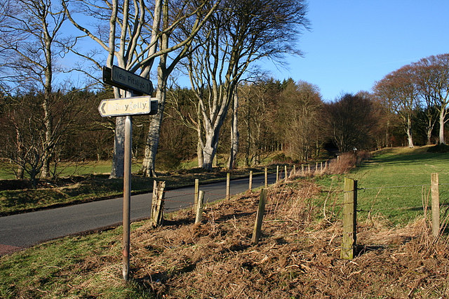
///deeper.octopus.pave. Near New Pitsligo, Aberdeenshire

Nearby Locations

Hill of Mahuncar

Related Wikis

Bonnykelly

Bonnykelly is a rural area to the west of the village of New Pitsligo in Aberdeenshire, Scotland. == References ==

New Byth

New Byth is a small inland planned village in the Banff and Buchan committee area of Aberdeenshire, Scotland, that lies a few miles northeast of Cuminestown...

New Pitsligo

New Pitsligo (Scots: Pitsligae), also known as Cavoch (locally Cyaak), is a village in Aberdeenshire, Scotland, quite near Fraserburgh. == Overview... ==

Garmond, Aberdeenshire

Garmond (Scottish Gaelic: Garbh Mhon(adh)) is a linear village in Monquhitter Parish which is located in Aberdeenshire, Scotland. It was founded c.1760...

Willows Animal Sanctuary

Willows Animal Sanctuary is an animal sanctuary in Fraserburgh, Aberdeenshire, Scotland. == History == Willows Animal Sanctuary was founded, on a 54-acre...

Crudie

Crudie is a settlement in Aberdeenshire, Scotland. It is situated on the A98. It has a primary school and a war memorial. == References ==

Netherbrae

Netherbrae is an area of farmland and small crofts in Aberdeenshire, Scotland. It is approximately 8 miles (13 km) north of Turriff and 9 miles (14 km...

Cuminestown

Cuminestown is a village in the Formartine area of Aberdeenshire, Scotland, and sits at the centre of the parish of Monquhitter. It is approximately 6...

Nearby Amenities

Located within 500m of 57.589121,-2.2523507
Power: pole
Lat/Long: 57.5856445/-2.2521624
Power: pole
Lat/Long: 57.5859205/-2.2512639
Power: pole
Lat/Long: 57.5862871/-2.2500408
Power: pole
Lat/Long: 57.5865632/-2.2491047
Power: pole
Lat/Long: 57.5876558/-2.2454837
Power: pole
Lat/Long: 57.5870678/-2.2474095
Power: pole
Lat/Long: 57.5868047/-2.2482625
Power: pole
Lat/Long: 57.5865876/-2.2466397
Power: pole
Lat/Long: 57.590557/-2.2559845
Power: pole
Lat/Long: 57.5903153/-2.2568128
Power: pole
Lat/Long: 57.5900838/-2.257606
Power: pole
Lat/Long: 57.5901363/-2.2586629
Power: pole
Lat/Long: 57.5932411/-2.251516
Power: pole
Lat/Long: 57.5925703/-2.2516495
Power: pole
Lat/Long: 57.5918722/-2.2517532
Power: pole
Lat/Long: 57.5911401/-2.2518739
Power: pole
Lat/Long: 57.5903954/-2.2519841
Power: pole
Lat/Long: 57.5898006/-2.2520942
Power: pole
Lat/Long: 57.5892932/-2.251228
Power: pole
Lat/Long: 57.5887847/-2.2503702
Power: pole
Lat/Long: 57.5883295/-2.2495866
Power: pole
Lat/Long: 57.5878095/-2.2486929
Power: pole
Lat/Long: 57.5874565/-2.2480639
Power: pole
Lat/Long: 57.5879333/-2.2445249
Power: pole
Lat/Long: 57.5873691/-2.2464649
Power: pole
Lat/Long: 57.5853438/-2.2531722
Power: pole
Lat/Long: 57.5854562/-2.2543688
Power: pole
Lat/Long: 57.585555/-2.2555612
Power: pole
Lat/Long: 57.5856639/-2.2567218
Power: pole
Lat/Long: 57.5857718/-2.257893
Power: pole
Lat/Long: 57.590187/-2.2596858
Power: pole
Lat/Long: 57.5905061/-2.2547384
Power: pole
Lat/Long: 57.5904425/-2.2534062
Power: pole
Lat/Long: 57.5871779/-2.2595174
The data included in this document is from www.openstreetmap.org. The data is made available under ODbL.

Have you been to Hill of Mahuncar?

Leave your review of Hill of Mahuncar below (or comments, questions and feedback).