Green Hill

Hill, Mountain in Yorkshire Ribble Valley

England

Green Hill

Ordnance Survey Cut Mark This mark can be found on the wall of St Mary's Church, Gisburn
The benchmark has a recorded height of 138.3304 metres above sea level.
For more detail see : <span class="nowrap"><a title="https://www.bench-marks.org.uk/bm36317" rel="nofollow ugc noopener" href="https://www.bench-marks.org.uk/bm36317">Link</a><img style="margin-left:2px;" alt="External link" title="External link - shift click to open in new window" src="https://s1.geograph.org.uk/img/external.png" width="10" height="10"/></span>
Ordnance Survey Cut Mark Credit: Peter Wood

Green Hill is a prominent geographical feature located in the county of Yorkshire, England. Situated in the heart of the Yorkshire Dales National Park, Green Hill is a notable hill/mountain that attracts hikers, nature enthusiasts, and tourists alike.

Rising to an elevation of approximately 500 meters (1,640 feet), Green Hill offers breathtaking panoramic views of the surrounding countryside. Its distinctively green slopes, covered in lush grass and dotted with wildflowers during the summer months, contribute to its name. The hill is characterized by its gentle incline, making it accessible to both experienced and novice hikers.

The area surrounding Green Hill is rich in flora and fauna, with a variety of habitats supporting a diverse range of wildlife. Rare and endangered species such as red grouse, curlews, and brown hares can often be spotted in the vicinity. Additionally, the hill is home to several species of wildflowers, including heather and bluebells, which create a vibrant and colorful landscape during the warmer seasons.

Green Hill offers numerous walking trails and footpaths, providing visitors with ample opportunities to explore its natural beauty. The most popular route to the summit begins at the village of Grassington, where walkers can follow well-marked trails that wind their way through picturesque valleys and ancient woodlands. From the summit of Green Hill, one can enjoy breathtaking views of Wharfedale and the surrounding Yorkshire Dales.

Overall, Green Hill stands as a prominent landmark in Yorkshire, offering a peaceful sanctuary for those seeking to immerse themselves in the natural beauty and tranquility of the region.

If you have any feedback on the listing, please let us know in the comments section below.

Green Hill Images

Images are sourced within 2km of 53.924007/-2.252816 or Grid Reference SD8347. Thanks to Geograph Open Source API. All images are credited.

Ordnance Survey Cut Mark This mark can be found on the wall of St Mary's Church, Gisburn
The benchmark has a recorded height of 138.3304 metres above sea level.
For more detail see : <span class="nowrap"><a title="https://www.bench-marks.org.uk/bm36317" rel="nofollow ugc noopener" href="https://www.bench-marks.org.uk/bm36317">Link</a><img style="margin-left:2px;" alt="External link" title="External link - shift click to open in new window" src="https://s1.geograph.org.uk/img/external.png" width="10" height="10"/></span>
Ordnance Survey Cut Mark
This mark can be found on the wall of St Mary's Church, Gisburn The benchmark has a recorded height of 138.3304 metres above sea level. For more detail see : LinkExternal link
Delicious Deli and Café - Gisburn
Fields East of Gisburn
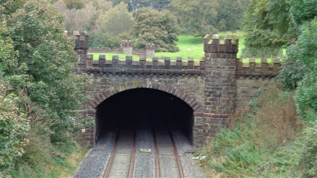
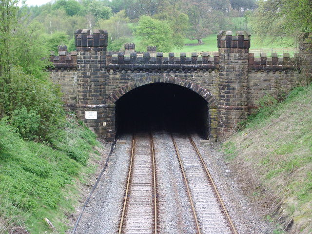
West Portal Gisburne Park  Railway Tunnel A cut and cover short tunnel required by the landowner and decorated appropriately. The turrets of the east portal can be seen as well across this part of Gisburne Park
West Portal Gisburne Park Railway Tunnel
A cut and cover short tunnel required by the landowner and decorated appropriately. The turrets of the east portal can be seen as well across this part of Gisburne Park
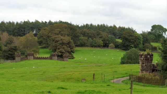
Gisburne Park Railway Tunnel Turrets A curious view of mock castle turrets in parkland, disguising a railway line
Gisburne Park Railway Tunnel Turrets
A curious view of mock castle turrets in parkland, disguising a railway line
Old Guide Stone by A682, Rimington Lane junction with Hardacre Lane (East face) The Guide Stone is located in angle of minor roads, next to grey metal junction box on the West side of the road.  Parish of Rimington (Ribble Valley District). Carved stone post, erected in the 18th Century, old edge chips. An earlier photograph can be found here: <a title="https://www.geograph.org.uk/photo/6076649" href="https://www.geograph.org.uk/photo/6076649">Link</a> 

Inscription reads:- 
TO / {hand to left}  / BurnLey /(1) 2 m : : TO / {hand to right} / (?) /5 ms / TO E {hand to left} / Gisbern / 1m 

Grade II listed. 
List Entry Number: 1165264 <span class="nowrap"><a title="https://historicengland.org.uk/listing/the-list/list-entry/1165264" rel="nofollow ugc noopener" href="https://historicengland.org.uk/listing/the-list/list-entry/1165264">Link</a><img style="margin-left:2px;" alt="External link" title="External link - shift click to open in new window" src="https://s1.geograph.org.uk/img/external.png" width="10" height="10"/></span> 

Milestone Society National ID: YW_XGIS
Old Guide Stone by A682, Rimington Lane junction with Hardacre Lane (East face)
The Guide Stone is located in angle of minor roads, next to grey metal junction box on the West side of the road.  Parish of Rimington (Ribble Valley District). Carved stone post, erected in the 18th Century, old edge chips. An earlier photograph can be found here: Link  Inscription reads:- TO / {hand to left} / BurnLey /(1) 2 m : : TO / {hand to right} / (?) /5 ms / TO E {hand to left} / Gisbern / 1m Grade II listed. List Entry Number: 1165264 LinkExternal link Milestone Society National ID: YW_XGIS
Old Guide Stone by A682, Rimington Lane junction with Hardacre Lane (West Face) The Guide Stone is located in angle of minor roads, next to grey metal junction box on the West side of the road.  Parish of Rimington (Ribble Valley District). Carved stone post, erected in the 18th Century, old edge chips. East face photograph can be found here: <a title="https://www.geograph.org.uk/photo/7383066" href="https://www.geograph.org.uk/photo/7383066">Link</a> 

Inscription reads:- 
TO / {hand to left}  / BurnLey /(1) 2 m : : TO / {hand to right} / (?) / 5 ms / TO E {hand to left} / Gisbern / 1m 

Grade II listed. 
List Entry Number: 1165264 <span class="nowrap"><a title="https://historicengland.org.uk/listing/the-list/list-entry/1165264" rel="nofollow ugc noopener" href="https://historicengland.org.uk/listing/the-list/list-entry/1165264">Link</a><img style="margin-left:2px;" alt="External link" title="External link - shift click to open in new window" src="https://s1.geograph.org.uk/img/external.png" width="10" height="10"/></span> 

Milestone Society National ID: YW_XGIS
Old Guide Stone by A682, Rimington Lane junction with Hardacre Lane (West Face)
The Guide Stone is located in angle of minor roads, next to grey metal junction box on the West side of the road.  Parish of Rimington (Ribble Valley District). Carved stone post, erected in the 18th Century, old edge chips. East face photograph can be found here: Link Inscription reads:- TO / {hand to left} / BurnLey /(1) 2 m : : TO / {hand to right} / (?) / 5 ms / TO E {hand to left} / Gisbern / 1m Grade II listed. List Entry Number: 1165264 LinkExternal link Milestone Society National ID: YW_XGIS
Old milestone This milestone which would have stood at the southeast corner of the A59/B6265 Bracewll Lane is now built into steps at the back of the White Bull PH in Gisburn.  This face is engraved with a hand pointing left/To/SKipton/9 Miles/hand pointing right/Gisbor(n)/2 Ms.  The other visible face is engraved with a hand pointing left To/Settle 11 ms/hand to right/Colne 7 ms.
Old milestone
This milestone which would have stood at the southeast corner of the A59/B6265 Bracewll Lane is now built into steps at the back of the White Bull PH in Gisburn. This face is engraved with a hand pointing left/To/SKipton/9 Miles/hand pointing right/Gisbor(n)/2 Ms. The other visible face is engraved with a hand pointing left To/Settle 11 ms/hand to right/Colne 7 ms.
Gisburne Park Entrance Lodges At the south entrance at the end of Park Road from the centre of Gisburn
Gisburne Park Entrance Lodges
At the south entrance at the end of Park Road from the centre of Gisburn
St Mary The Virgin, Gisburn
Bentlea Road, Gisburn
The Parish Church of St Mary the Virgin, Gisburn It is assumed (<span class="nowrap"><a title="http://www.gisburn.org.uk/gisburnvillage/church_history.htm" rel="nofollow ugc noopener" href="http://www.gisburn.org.uk/gisburnvillage/church_history.htm">Link</a><img style="margin-left:2px;" alt="External link" title="External link - shift click to open in new window" src="https://s1.geograph.org.uk/img/external.png" width="10" height="10"/></span> ) that the foundations of the present church could have been about 1135 although it is possible that there was a church on this site before this There is evidence ’the Rector of Gisburne Church was present at the laying of the foundation stone at Salley (Sawley) Abbey in 1147’. Large cylindrical pillars at the front of the church have been dated as being of 12th century origin

.

The Church has been restored on more than one occasion. The upper part of the tower is 14th century, the porch is 15th century and leads to the south doorway which is 13th century. It is thought that a major restoration was carried out in the late 16th century, Part of the archways originated from the Sawley Abbey after the Dissolution. A further restoration took place in 1872.

<span class="nowrap"><a title="http://www.gisburn.org.uk/gisburnvillage/church_history.htm" rel="nofollow ugc noopener" href="http://www.gisburn.org.uk/gisburnvillage/church_history.htm">Link</a><img style="margin-left:2px;" alt="External link" title="External link - shift click to open in new window" src="https://s1.geograph.org.uk/img/external.png" width="10" height="10"/></span>  Gisburn Village web site
The Parish Church of St Mary the Virgin, Gisburn
It is assumed (LinkExternal link ) that the foundations of the present church could have been about 1135 although it is possible that there was a church on this site before this There is evidence ’the Rector of Gisburne Church was present at the laying of the foundation stone at Salley (Sawley) Abbey in 1147’. Large cylindrical pillars at the front of the church have been dated as being of 12th century origin . The Church has been restored on more than one occasion. The upper part of the tower is 14th century, the porch is 15th century and leads to the south doorway which is 13th century. It is thought that a major restoration was carried out in the late 16th century, Part of the archways originated from the Sawley Abbey after the Dissolution. A further restoration took place in 1872. LinkExternal link Gisburn Village web site
Gisburn Main Street, The White Bull
Gisburn War Memorial and garden In the centre of the village.
Gisburn War Memorial and garden
In the centre of the village.
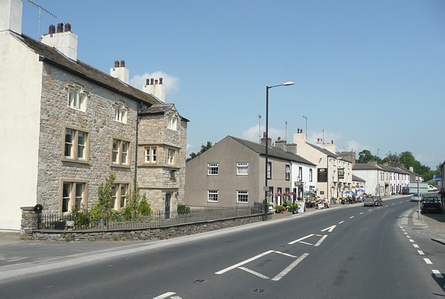
Main Street, Gisburn The A59 becomes Main Street in the village. This is looking east from the western edge of Gisburn.
Main Street, Gisburn
The A59 becomes Main Street in the village. This is looking east from the western edge of Gisburn.
St. Mary the Virgin, Gisburn Church of England parish church, occupying a central position in the village, alongside the A59.
St. Mary the Virgin, Gisburn
Church of England parish church, occupying a central position in the village, alongside the A59.
Rough grazing at Gisburn Close to the centre of the village, looking west from the A682.
Rough grazing at Gisburn
Close to the centre of the village, looking west from the A682.
Walter Hill Approaching the summit of Walter Hill near Gisburn - one of many drumlins that abound in this area
Walter Hill
Approaching the summit of Walter Hill near Gisburn - one of many drumlins that abound in this area
Show me another place!

Green Hill is located at Grid Ref: SD8347 (Lat: 53.924007, Lng: -2.252816)

Division: West Riding

Administrative County: Lancashire

District: Ribble Valley

Police Authority: Lancashire

What 3 Words

///zaps.clan.adults. Near Barnoldswick, Lancashire

Related Wikis

Gisburn

Gisburn (formerly Gisburne) is a village and civil parish within the Ribble Valley borough of Lancashire, England. Historically within the West Riding...

Gisburn Tunnel

Gisburn Tunnel is a short railway tunnel on the Ribble Valley line in Lancashire, England. The tunnel is 157 yards (144 m) long, just to the east of Gisburn...

Gisburn railway station

Gisburn railway station served the small village of Gisburn, which is now in Lancashire, England, but was in the West Riding of Yorkshire at the time....

Gisburne Park

Gisburne Park is an 18th-century country house and associated park in Gisburn, Lancashire, England, in the Ribble Valley some 6 miles (10 km) north-east...

Middop

Middop is a rural hamlet and civil parish in Lancashire, England. It is in Ribble Valley district. Middop is near the villages of Rimington and Gisburn...

Stock Beck

Stock Beck is a minor river in the West Craven area of Pendle, Lancashire (formerly in Yorkshire). It is 8.25 miles (13.27 km) long and has a catchment...

Bracewell and Brogden

Bracewell and Brogden is a civil parish in the West Craven area of the Borough of Pendle in Lancashire, England. According to the 2001 census it had a...

A59 road

The A59 is a major road in England which is around 109 miles (175 km) long and runs from Wallasey, Merseyside to York, North Yorkshire. The alignment formed...

Related Videos

Todber Valley Holiday Park, Lancashire

Get a preview of what you can expect at our Todber Valley Holiday Park in Lancashire. Todber Valley Holiday Park Borders rural ...

Todber Valley Holiday Park | Weekends Holidays

todbervalleyholidaypark #caravanholiday #parkdeanresorts #weekendsholidays At Todber Valley Holiday Park, located in ...

Holiday Lodge Hire at Holgates Ribble Valley

Take a look around our brand-new holiday lodges, available to book for weekend breaks, week long breaks and also mid-week ...

Caravans For Sale at Todber Valley Holiday Park, Lancashire

Join us to experience what it is like to own a holiday home at Todber Valley Holiday Park in Lancashire. Todber Valley Holiday ...

Nearby Amenities

Located within 500m of 53.924007,-2.252816
Barrier: yes
Lat/Long: 53.9204627/-2.2566267
The data included in this document is from www.openstreetmap.org. The data is made available under ODbL.

Have you been to Green Hill?

Leave your review of Green Hill below (or comments, questions and feedback).